Salient (geography)
A salient is an elongated protrusion of a geopolitical entity, such as a subnational entity or a sovereign state.
While similar to a peninsula in shape, a salient is not surrounded by water on three sides. Instead, it has a land border on at least two sides and extends out from the larger geographical body of the administrative unit.
In American English the term panhandle is often used to describe a relatively long and narrow salient, such as the westernmost extension of Oklahoma. Less common descriptors include chimney, or stovepipe (if protruding northward, as a chimney does from a roof, as with the northernmost extremity of West Virginia) and bootheel (if protruding southward, as the heel underneath a boot, such as the Missouri Bootheel).
Origin
The term salient is derived from military salients. The term "panhandle" derives from the analogous part of a cooking pan, and its use is generally confined to the United States.
The salient shape can be the result of arbitrarily drawn international or subnational boundaries, though the location of administrative borders can also take into account other considerations such as economic ties or topography.
Country-level salients
Africa

- Cibitoke Province, Burundi
- Far North Region, Cameroon
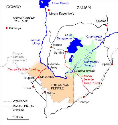
- Congo Pedicle, Democratic Republic of the Congo
- Kongo Central, Democratic Republic of the Congo
- Southern Red Sea Region, Eritrea
- Gambela Region, Ethiopia
- Nimba County, Liberia
- Nsanje District, Malawi
- Kayes Region, Mali
- Azawad, Mali
- Tete Province, Mozambique
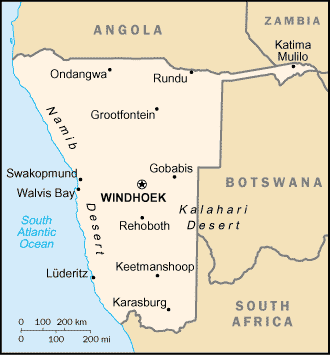
- Caprivi Strip, Namibia
- Casamance, Senegal
- Kalahari Gemsbok National Park, South Africa
- Blue Nile, Sudan
- Wadi Halfa Salient, Sudan
- Kagera Region, Tanzania
Americas

- Misiones, Argentina
- Roraima, Brazil
- Southern Ontario, Canada (particularly Ontario Peninsula)
- Tatshenshini-Alsek Park, British Columbia, Canada
- Amazon Trapezium, Amazonas, Colombia
- Southeast Guainía Department, Colombia
- Yavarate, Vaupés Department, Colombia
- Petén, Guatemala
- Tumbes Region, Peru
- Southeast Alaska, Alaska, United States (see also Panhandles in the United States)
- Amazonas, Venezuela
Asia

- Wakhan Corridor, Afghanistan
- Chittagong, Bangladesh
- Rangpur, Bangladesh
- Tanintharyi Region, Burma (Myanmar)
- Parrot's Beak, Cambodia
- Louroujina Salient, Cyprus
- Seven Sister States, India (largest in the world)
- Sikkim, India
- Jerusalem corridor, Israel
- Galilee Panhandle, Israel
- Mafraq Governorate, Jordan
- Mangystau Region, Kazakhstan
- Batken, Kyrgyzstan
- Phongsaly Province, Laos
- North Hamgyŏng, South Hamgyŏng, and Ryanggang, together comprise the "panhandle" of North Korea
- Primorsky Krai, Russia
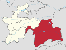
- Sughd, Tajikistan
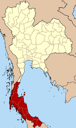
- Southern Thailand, Thailand
- Hatay Province, Turkey
- Surxondaryo Region, Uzbekistan
- Tây Ninh Province, Vietnam

Europe

- Syunik, Armenia
- Tyrol and Vorarlberg together comprise the western "panhandle" of Austria
- West-Flanders, Belgium
- Neum, Bosnia and Herzegovina
- Vidin Province, Bulgaria
- Dubrovnik-Neretva County, Croatia
- Cheb District, Czech Republic
- Šluknov Hook, Czech Republic
- Laatre, Viljandi County, Estonia
- Enontekiö, Finland
- Charleville-Mézières, France
- Kakheti, Georgia
- Western Thrace, Greece
- Donegal, Ireland
- Monaghan, Ireland
- Province of Trieste, Italy
- Dieveniškės Appendix, Lithuania
- Briceni District, Moldova
- Castelré, Noord-Brabant, the Netherlands
- Limburg, the Netherlands
- Pasvikdalen valley, Norway
- Bogatynia, Poland
- Melgaço and north of Monção and Arcos de Valdevez (Viana do Castelo District), Portugal
- Tourém in north of Montalegre (Vila Real District), Portugal
- Couto Misto in north of Montalegre (Vila Real District), Portugal
- Miranda do Douro, Mogadouro and Vimioso (Bragança District), Portugal
- Moura and eastern Barrancos (Beja District) and Mourão (Évora District), Portugal
- Olivenza claim of Portugal in Spain
- Bryansk Oblast, Russia
- Galicia, Spain
- Canton of Geneva, Switzerland
- Canton of Schaffhausen, Switzerland
- Bernina, Inn, Lugano, Mendrisio and Porrentruy Districts, Switzerland
- Budjak, Ukraine
Subnational salients
The following locations are salients in First-level administrative subdivisions of nations.
Subnational salients in Africa

- Tafraoui, Oran Province, Algeria
- Southwestern Saïda Province, Algeria
- Northeastern Bié Province, Angola
- Eastern Kgalagadi District, Botswana
- Balé Province, Boucle du Mouhoun Region, Burkina Faso
- Kouritenga Province, Centre-Est Region, Burkina Faso
- Northwest Bujumbura Rural Province, Burundi
- Northern Muyinga Province, Burundi
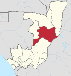
- Okoyo District, Cuvette Department, Republic of the Congo
- Kimongo District, Niari Department, Republic of the Congo
- Northwestern Wele-Nzas Province, Equatorial Guinea
- Sitti Zone, Somali Region, Ethiopia
- Haut-Komo Department, Woleu-Ntem Province, Gabon
- Upper Denkyira West District, Central Region, Ghana
- Télimélé Prefecture, Kindia Region, Guinea
- Northeast Mamou Prefecture, Mamou Region, Guinea
- Western Isiolo County, Kenya
- Eastern Al Wahat District, Libya
- Southern Mzimba District, Northern Region, Malawi
- Eastern Dakhlet Nouadhibou Region, Mauritania
- Boumdeid Department, Assaba Region, Mauritania
- Southeastern Tete Province, Mozambique
- Gossas Department, Fatick Region, Senegal
- Southern Uvinza District, Kigoma Region, Tanzania
- Babati, Hanang, and Mbulu Districts, Manyara Region, Tanzania
- Gokwe North and Gokwe South Districts, Midlands Province, Zimbabwe
Subnational salients in the Americas

- Southern Buenos Aires Province, Argentina
- Luis Calvo, Chuquisaca Department, Bolivia
- Sud Cinti, Chuquisaca Department, Bolivia
- Whale Coast, Bahia, Brazil
- Northern Mato Grosso, Brazil
- Triângulo Mineiro, Minas Gerais, Brazil
- Northwestern British Columbia, Canada
- Arauco Province, Bío Bío Region, Chile
- San Antonio Province, Valparaíso Region, Chile
- Santander Department northern tip, Colombia
- Southeastern Cauca Department, Colombia
- Urabá region, Antioquia Department, Colombia
- Western Puntarenas Province, Costa Rica
- Guamá, Santiago de Cuba Province, Cuba
- Southern Hato Mayor Province, Dominican Republic
- Southern Samaná Province, Dominican Republic
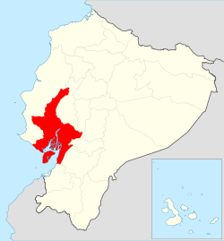
- Cotacachi Canton, Imbabura Province, Ecuador
- Southeastern Napo Province, Ecuador
- Balzar and El Empalme Cantons, Guayas Province, Ecuador
- Southern San Miguel Department, El Salvador
- Northern East Berbice-Corentyne, Guyana
- Norte, Jalisco, Mexico
- Eastern Tabasco, Mexico
- Southeastern Zacatecas, Mexico
- Southern Zacatecas, Mexico
- Chiriquí Grande District, Bocas del Toro Province, Panama
- Southern Chimán District, Panamá Province, Panama
- Mariato District, Veraguas Province, Panama
- Northern Tapanahony, Sipaliwini District, Suriname
- Páez, Apure, Venezuela
- Western Andrés Eloy Blanco Municipality, Barinas, Venezuela
- Arismendi Municipality, Barinas, Venezuela
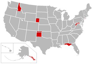
Panhandles in the United States
| State | Largest city | Population | Area (sq mi) | Area (km2) | Population density (per sq mi) | Population density (/km2) |
|---|---|---|---|---|---|---|
| Alaska | Juneau | 71,616 | 35,138 | 91,010 | 2 | 0.77 |
| Connecticut | Stamford | 224,284 | 96 | 250 | 2,336 | 902 |
| Florida* | Tallahassee | 1,407,925 | 11,304 | 29,280 | 125 | 48 |
| Idaho | Coeur d'Alene | 317,751 | 21,013 | 54,420 | 15 | 5.8 |
| Maryland† | Frederick | 492,950 | 2,194 | 5,680 | 225 | 87 |
| Nebraska | Scottsbluff | 87,789 | 14,258 | 36,930 | 6 | 2.3 |
| Oklahoma | Guymon | 28,751 | 5,687 | 14,730 | 5 | 1.9 |
| Texas | Amarillo | 427,927 | 25,887 | 67,050 | 17 | 6.6 |
| Eastern West Virginia | Martinsburg | 261,041 | 3,499 | 9,060 | 75 | 29 |
| Northern West Virginia | Wheeling | 132,295 | 601 | 1,560 | 220 | 85 |
* This definition includes the following counties: Bay, Calhoun, Escambia, Franklin, Gadsden, Gulf, Holmes, Jackson, Jefferson, Leon, Liberty, Madison, Okaloosa, Santa Rosa, Taylor, Wakulla, Walton, and Washington.
† This definition includes the following counties: Allegany, Frederick, Garrett, and Washington
Many people in the Pacific Northwest refer to the extreme northern section of Idaho's panhandle as "The Chimney", due to its resemblance to a chimney when viewed on maps.
Although Utah, like Nebraska, has a protrusion from its otherwise straight border, it is not usually considered a panhandle, as half of the Salt Lake City metropolitan area, the most populous region in the state and the home of the state's capital, is located in the region. Likewise, though New York has a southern protrusion that is more conspicuous than e.g. the Connecticut, Texas and Nebraska Panhandles, this is never considered a panhandle since it accommodates the most densely populated parts of the state. (In New York's case, its irregular shape leaves certain regions up for debate. From a different perspective, that region is part of the New York mainland while a western salient juts out.) Thus, the concept of a panhandle may not be purely geographic but may also have a demographic component.
- The six northwest Cook County, Illinois townships, outside of Chicago.[1]
- The Pittsburgh, Cincinnati, Chicago and St. Louis Railway was often called the Panhandle, as it crossed the Northern Panhandle of West Virginia.
- The San Francisco Panhandle, California, a small park which is an extension of the much larger Golden Gate Park
- Northern part of Lancaster County, South Carolina
- Harbor Gateway, Los Angeles, California
- Northwestern four townships of Montcalm County, Michigan
Subnational salients in Asia


- Wakhan District, Badakhshan Province, Afghanistan
- Nawa District, Ghazni Province, Afghanistan
- Chishti Sharif District, Herat Province, Afghanistan
- Eastern Sarpang District, Bhutan
- Northern Mandalay Division, Burma
- Eastern Chuzhou, Anhui, China PR
- Western Gannan Tibetan Autonomous Prefecture, Gansu, China PR
- Jiuquan, Pingliang and Qingyang, Gansu, China PR
- Daxing'anling Prefecture, Heilongjiang, China PR
- Zhaotong, Yunnan, China PR
- Koraput and Malkangiri districts, Odisha, India
- Kota division, Rajasthan, India
- Southern Jhansi division, Uttar Pradesh, India
- Eastern salient of Java, East Java, Indonesia
- Tabalong Regency, South Kalimantan, Indonesia
- East Luwu Regency, South Sulawesi, Indonesia
- Pasaman Regency, West Sumatra, Indonesia
- Semirom County, Isfahan Province, Iran
- Southwest Razavi Khorasan Province, Iran
- Southern Yazd Province, Iran
- Wadi Araba Department, Aqaba Governorate, Jordan
- Russeifa Department, Zarqa Governorate, Jordan
- Southwest Panfilov District, Chuy Region, Kyrgyzstan
- Chong-Alay District, Osh Region, Kyrgyzstan
- Nabatieh District, Nabatieh Governorate, Lebanon
- Eastern Achham District, Far-Western Region, Nepal
- Western Surkhet District, Mid-Western Region, Nepal
- Bannu, Karak, and Kohat Divisions, Khyber Pakhtunkhwa, Pakistan
- Eastern Maguindanao, Philippines
- Cainta, Rizal[2]
- Makati City, Philippines
- Trincomalee District, Eastern Province, Sri Lanka
- Al-Suqaylabiyah District, Hama Governorate, Syria
- Darvoz District, Gorno-Badakhshan Autonomous Region, Tajikistan
- Western Dhamar Governorate, Yemen
- South Jakarta, Jakarta Special Capital Region, and Depok, West Java, Indonesia.
Subnational salients in Europe

- Southern Gmunden, Upper Austria, Austria
- Viken, Norway
- Parikkala, South Karelia, Finland
- Ruokolahti, South Karelia, Finland
- Varkaus, Pohjois-Savo, Finland
- Lower Franconia, Bavaria, Germany
- Osnabrück District and City, Lower Saxony, Germany
- Altenburger Land, Thuringia, Germany
- Southeastern Győr-Moson-Sopron County, Hungary
- Northern Pest County, Hungary
- Clonlisk, County Offaly, Leinster, Ireland
- Province of Rieti, Lazio, Italy
- Raseiniai District Municipality, Kaunas County, Lithuania
- Rivierenland, Gelderland, the Netherlands
- Steenwijkerland, Overijssel, the Netherlands
- Mourão, Évora District, Portugal
- Vorkuta District, Komi Republic, Russia
- Negueira de Muñiz, Galicia (Spain), Spain
- A Mezquita, Galicia, Spain
- Diessenhofen, Schlatt bei Diessenhofen, and Basadingen-Schlattingen, Frauenfeld District, Thurgau, Switzerland
- Monthey District, Valais, Switzerland
- Buckfastleigh, Teignbridge, United Kingdom
- Ceiriog Valley, Wrexham County Borough, Wales, United Kingdom
- Western New Forest District, Hampshire, United Kingdom
- Newmarket, Suffolk, United Kingdom
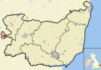
- North Cornwall, Cornwall, United Kingdom
- South Staffordshire, Staffordshire, United Kingdom
- The area around Tring, Hertfordshire, United Kingdom
Subnational salients in Oceania


- Northeastern Nadroga-Navosa Province, Western Division, Fiji
- Southern Anetan District, Nauru
- Rangitaiki River Valley, Bay of Plenty Region, New Zealand
- Hunter River Valley, Otago region, New Zealand
- Upper Rangitata Valley, Timaru District, New Zealand
- Upper Waitaki Valley, Waitaki District, New Zealand
- Northeastern West New Britain Province, Papua New Guinea
See also
- Bootheel
- Border irregularities of the United States
- Border
- Chicken's Neck (disambiguation)
- Corridor (disambiguation)
- Enclave and exclave
- Fergana Valley (triple junction of Uzbekistan, Kyrgyzstan and Tajikistan)
- Gerrymandering
- Political geography
- Salients, re-entrants and pockets
- The Thumb
References
- "Cook County Forest Preserve District Recreational Facilities". Users.rcn.com. Retrieved 2012-11-15.
- "San Isidro". Google Maps. Google LLC. Retrieved 14 January 2020.
Further reading
- Robert Reid. "America's Panhandles, Ranked From 1 to 10". National Geographic. Retrieved 2019-05-16.