Chittagong Division
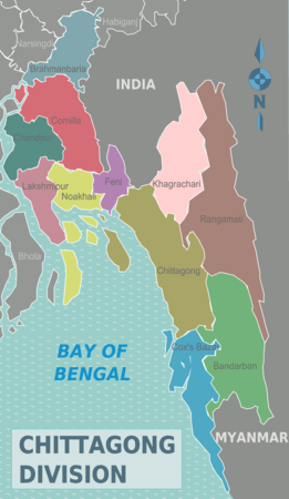
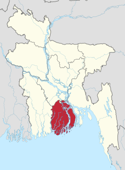
Chittagong Division is geographically the largest of the eight administrative divisions of Bangladesh. It covers the south-easternmost areas of the country, with a total area of 33,771.18 km2 (13,039.13 sq mi)[2] and a population at the 2011 census of 28,423,019. The administrative division includes mainland Chittagong District, neighbouring districts and the Chittagong Hill Tracts.
Chittagong Division চট্টগ্রাম বিভাগ | |
|---|---|
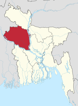
 Location of Chittagong in Bangladesh | |
 Districts of Chittagong Division | |
| Coordinates: 22°55′N 91°30′E | |
| Country | |
| Capital | Chittagong |
| Area | |
| • Total | 33,771.18 km2 (13,039.13 sq mi) |
| Population (2011 census) | |
| • Total | 28,423,019 |
| • Density | 840/km2 (2,200/sq mi) |
| Language | |
| • Native | Chittagonian |
| Time zone | UTC+6 (BST) |
| ISO 3166 code | BD-B |
| HDI (2017) | 0.610[1] medium |
| Notable sport teams | Chattogram Challengers, Chittagong Division, Chittagong Abahani |
| Website | www |
Chittagong Division is home to Cox's Bazar, the longest natural sea beach in the world.;[3][4] as well as St. Martin's Island, Bangladesh's sole coral reef.
Administration
Chittagong Division is subdivided into eleven districts (zilas) and thence into 99 sub-districts (upazilas). The first six districts listed below comprise the north-western portion (37.6%) of the division, while the remaining five comprise the south-eastern portion (62.4%), the two portions being separated by the lower (or Bangladeshi) stretch of the Feni River; the upland districts of Khagrachhari, Rangamati and Bandarban together comprise that area previously known as the Chittagong Hill Tracts. Before 1995, the four districts of Sylhet Division were also a part of Chittagong Division.
| Name | Capital | Area (km²) | Population 1991 Census | Population 2001 Census | Population 2011 Census |
|---|---|---|---|---|---|
| Brahmanbaria District | Brahmanbaria | 1,881.20 | 2,141,745 | 2,398,254 | 2,840,498 |
| Comilla District | Comilla | 3,146.30 | 4,032,666 | 4,595,539 | 5,387,288 |
| Chandpur District | Chandpur | 1,645.32 | 2,032,449 | 2,271,229 | 2,416,018 |
| Lakshmipur District | Lakshmipur | 1,440.39 | 1,312,337 | 1,489,901 | 1,729,188 |
| Noakhali District | Noakhali | 3,685.87 | 2,217,134 | 2,577,244 | 3,108,083 |
| Feni District | Feni | 990.36 | 1,096,745 | 1,240,384 | 1,437,371 |
| North of the Feni River (proposed new Comilla Division) | 12,789.50 | 12,863,076 | 14,572,569 | 16,918,446 | |
| Khagrachhari District | Khagrachhari | 2,749.16 | 342,488 | 525,664 | 613,917 |
| Rangamati District | Rangamati | 6,116.11 | 401,388 | 508,182 | 595,979 |
| Bandarban District | Bandarban | 4,479.01 | 230,569 | 298,120 | 388,335 |
| Chittagong District | Chittagong | 5,282.92 | 5,296,127 | 6,612,140 | 7,616,352 |
| Cox's Bazar District | Cox's Bazar | 2,491.85 | 1,419,260 | 1,773,709 | 2,289,990 |
| South of the Feni River (proposed reduced Chittagong Division) | 21,119.05 | 7,689,832 | 9,717,815 | 11,504,546 | |
| Total Districts | 11 | 33,908.55 | 20,552,908 | 24,290,384 | 28,423,019 |
See also
Sources
Census figures for 1991, 2001 and 2011 are from Bangladesh Bureau of Statistics, Population Census Wing. The 2011 Census figures are based on preliminary results.
References
- "Sub-national HDI - Area Database - Global Data Lab". hdi.globaldatalab.org. Retrieved 13 September 2018.
- Sajahan Miah (2012). "Chittagong Division". In Sirajul Islam and Ahmed A. Jamal (ed.). Banglapedia: National Encyclopedia of Bangladesh (Second ed.). Asiatic Society of Bangladesh.
- Ethirajan, Anbarasan (26 December 2012). "Bangladesh's Cox's Bazar: A paradise being lost?". BBC World. Retrieved 29 January 2015.
- The Europa World Year Book 2003. Taylor & Francis. 2003. p. 679. ISBN 978-1-85743-227-5.
External links
| Wikivoyage has a travel guide for Chittagong Division. |
Places adjacent to Chittagong Division | ||||||||||
|---|---|---|---|---|---|---|---|---|---|---|
| ||||||||||

| Barisal Division |
|  |
|---|---|---|
| Chittagong Division | ||
| Dhaka Division | ||
| Khulna Division | ||
| Mymensingh Division | ||
| Rajshahi Division | ||
| Rangpur Division | ||
| Sylhet Division | ||