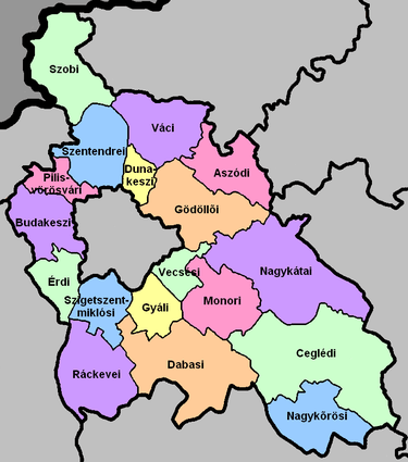
Pest County
Pest (Hungarian: Pest megye, pronounced [ˈpɛʃt]; German: Komitat Pest) is a county (megye) in central Hungary. It covers an area of 6,393.14 square kilometres (2,468.41 sq mi), and has a population of 1,213,090 (2009). It surrounds the national capital Budapest and the majority of the county's population (65.2%/790,995 in 2009) live in the suburbs of Budapest. It shares borders with Slovakia and the Hungarian counties Nógrád, Heves, Jász-Nagykun-Szolnok, Bács-Kiskun, Fejér, and Komárom-Esztergom. The River Danube flows through the county. The capital of Pest County is Budapest (administratively separate), but it is planned to completely separate the capital from the county at least until 2020, as it loses catch-up aids from the European Union because of the high development of Budapest.
Pest County Pest megye | |
|---|---|
.jpg)  .jpg) Descending, from top: the Börzsöny Mountain in Nagybörzsöny village, landscapes of Vác, and landscapes of Kemence | |
 Flag  Coat of arms | |
 Pest County within Hungary | |
| Country | |
| Region | Central Hungary |
| County seat | Budapest |
| Districts | 18 districts
|
| Government | |
| • President of the General Assembly | István Szabó (Fidesz-KDNP) |
| Area | |
| • Total | 6,393.14 km2 (2,468.41 sq mi) |
| Area rank | 3rd in Hungary |
| Population (2015) | |
| • Total | 1,226,115[1] |
| • Rank | 1st in Hungary |
| • Density | 191.8/km2 (497/sq mi) |
| Postal code | 20xx – 23xx, 2440, 2461, 260x – 263x, 2680 – 2683, 27xx |
| Area code(s) | (+36) 23, 24, 26, 27, 28, 29, 53 |
| ISO 3166 code | HU-PE |
| Website | www |
History
The present county Pest was formed after World War II, when the former county Pest-Pilis-Solt-Kiskun was split in two parts (the other part is within present-day Bács-Kiskun). Pest County also existed in the early days of the medieval Kingdom of Hungary (11th century). Its territory comprised approximately the north-eastern part of present Pest County. It was combined with adjacent Pilis county before the 15th century. More information can be found at the entry of former Pest-Pilis-Solt-Kiskun county.
Demographics
Religion in Pest County (2011 census)
In 2015, it had a population of 1,226,115 and the population density was 192/km².
| Year | County population[2] | Change |
|---|---|---|
| 1949 | 686,953 | n/a |
| 1960 | 13.76% | |
| 1970 | 12.43% | |
| 1980 | 10.83% | |
| 1990 | -2.46% | |
| 2001 | 14.11% | |
| 2011 | 12.37% | |
| 2015 | 0.71% |
Ethnicity
Besides the Hungarian majority, the main minorities are the Germans (approx. 25,000), Roma (20,000), Slovaks (6,000), Romanians (4,000) and Serbs (1,500).
Total population (2011 census): 1,217,476
Ethnic groups (2011 census):[3]
Identified themselves: 1,090,882 persons:
- Hungarians: 1,024,768 (93.94%)
- Germans: 24,994 (2.29%)
- Gypsies: 20,065 (1.84%)
- Others and indefinable: 21,055 (1.93%)
Approx. 178,000 persons in Pest County did not declare their ethnic group at the 2011 census.
Religion
Religious adherence in the county according to 2011 census:[4]
- Catholic – 445,106 (Roman Catholic – 435,717; Greek Catholic – 9,235);
- Reformed – 134,848;
- Evangelical – 32,564;
- Orthodox – 1,796;
- Judaism – 947;
- Other religions – 26,485;
- Non-religious – 200,430;
- Atheism – 19,869;
- Undeclared – 355,431.
Economy
The Gross domestic product (GDP) of the county was 13.8 billion euros in 2018, accounting for 10.3% of Hungary's economic output. GDP per capita adjusted for purchasing power was 17,000 euros or 56% of the EU27 average in the same year. The GDP per employee was 69% of the EU average.[5]
Regional structure
| № | English and Hungarian names |
Area (km²) |
Population (2011) |
Density (pop./km²) |
Seat | № of municipalities |
| 1 | Aszód District Aszódi járás |
298.37 | 37,472 | 126 | Aszód | 11 |
| 2 | Budakeszi District Budakeszi járás |
288.95 | 83,670 | 290 | Budakeszi | 12 |
| 3 | Cegléd District Ceglédi járás |
886.30 | 88,952 | 100 | Cegléd | 12 |
| 4 | Dabas District Dabasi járás |
614.23 | 48,289 | 79 | Dabas | 11 |
| 5 | Dunakeszi District Dunakeszi járás |
103.08 | 78,634 | 763 | Dunakeszi | 4 |
| 6 | Érd District Érdi járás |
184.29 | 116,510 | 632 | Érd | 7 |
| 7 | Gödöllő District Gödöllői járás |
449.66 | 139,826 | 311 | Gödöllő | 15 |
| 8 | Gyál District Gyáli járás |
170.99 | 40,853 | 239 | Gyál | 4 |
| 9 | Monor District Monori járás |
329.81 | 64,016 | 194 | Monor | 12 |
| 10 | Nagykáta District Nagykátai járás |
710.12 | 73,959 | 104 | Nagykáta | 15 |
| 11 | Nagykőrös District Nagykőrösi járás |
349.25 | 27,977 | 80 | Nagykőrös | 3 |
| 12 | Pilisvörösvár District Pilisvörösvári járás |
130.81 | 53,201 | 407 | Pilisvörösvár | 9 |
| 13 | Ráckeve District Ráckevei járás |
417.05 | 35,732 | 86 | Ráckeve | 11 |
| 14 | Szentendre District Szentendrei járás |
326.58 | 77,802 | 238 | Szentendre | 13 |
| 15 | Szigetszentmiklós District Szigetszentmiklósi járás |
211.28 | 110,448 | 523 | Szigetszentmiklós | 9 |
| 16 | Szob District Szobi járás |
438.32 | 24,875 | 57 | Szob | 17 |
| 17 | Vác District Váci járás |
362.19 | 68,234 | 188 | Vác | 18 |
| 18 | Vecsés District Vecsési járás |
119.74 | 47,026 | 393 | Vecsés | 4 |
| Pest County | 6,393.14 | 1,217,476 | 192 | Budapest | 187 | |
|---|---|---|---|---|---|---|
Politics
The Pest County Council, elected at the 2019 local government elections, is made up of 44 counselors,[6] with the following party composition:
| Party | Seats | Current County Assembly | ||||||||||||||||||||||||
|---|---|---|---|---|---|---|---|---|---|---|---|---|---|---|---|---|---|---|---|---|---|---|---|---|---|---|
| Fidesz-KDNP | 24 | |||||||||||||||||||||||||
| Momentum Movement | 9 | |||||||||||||||||||||||||
| Democratic Coalition | 7 | |||||||||||||||||||||||||
| Jobbik | 4 | |||||||||||||||||||||||||
Municipalities
Pest County has 1+(Budapest) urban county, 47 towns, 17 large villages and 122 villages.
- City with county rights
(ordered by population, as of 2011 census)
- Érd (63,631)
- Towns
- Dunakeszi (40,545)
- Cegléd (36,645)
- Szigetszentmiklós (34,708)
- Vác (33,831)
- Gödöllő (32,522)
- Budaörs (26,757)
- Szentendre (25,310)
- Nagykőrös (24,134)
- Gyál (23,338)
- Dunaharaszti (20,473)
- Vecsés (20,088)
- Fót (19,068)
- Százhalombatta (17,952)
- Monor (17,626)
- Göd (17,476)
- Szigethalom (16,886)
- Pomáz (16,622)
- Dabas (16,386)
- Gyömrő (16,250)
- Veresegyház (15,998)
- Pécel (15,168)
- Abony (14,916)
- Pilisvörösvár (13,667)
- Budakeszi (13,502)
- Törökbálint (12,841)
- Biatorbágy (12,484)
- Nagykáta (12,467)
- Albertirsa (12,016)
- Kistarcsa (11,953)
- Maglód (11,738)
- Pilis (11,568)
- Üllő (11,425)
- Isaszeg (11,152)
- Tököl (10,851)
- Budakalász (10,619)
- Kerepes (10,068)
- Ráckeve (9,755)
- Halásztelek (9,200)
- Diósd (9,056)
- Ócsa (8,985)
- Piliscsaba (8,472)
- Sülysáp (8,195)
- Tura (7,774)
- Dunavarsány (7,363)
- Őrbottyán (7,102)
- Aszód (6,258)
- Tápiószele (5,914)
- Zsámbék (5,174)
- Örkény (4,730)
- Nagymaros (4,679)
- Szob (2,794)
- Újhartyán (2,685)
- Visegrád (1,718)
- Villages
- Acsa
- Alsónémedi

- Apaj
- Áporka
- Bag
- Bénye
- Bernecebaráti
- Budajenő
- Bugyi
- Ceglédbercel
- Csemő
- Csévharaszt
- Csobánka
- Csomád
- Csömör
- Csörög
- Csővár
- Dánszentmiklós
- Dány
- Délegyháza
- Domony
- Dömsöd
- Dunabogdány
- Ecser
- Erdőkertes
- Farmos
- Felsőpakony
- Galgagyörk
- Galgahévíz
- Galgamácsa
- Gomba
- Herceghalom
- Hernád
- Hévízgyörk
- Iklad
- Inárcs
- Ipolydamásd
- Ipolytölgyes
- Jászkarajenő
- Kakucs
- Kartal
- Káva
- Kemence
- Kiskunlacháza
- Kismaros
- Kisnémedi
- Kisoroszi
- Kocsér
- Kosd
- Kóka
- Kőröstetétlen
- Kóspallag
- Leányfalu
- Letkés
- Lórév
- Majosháza
- Makád
- Márianosztra
- Mende
- Mikebuda
- Mogyoród
- Monorierdő
- Nagybörzsöny
- Nagykovácsi
- Nagytarcsa
- Nyáregyháza
- Nyársapát
- Pánd
- Páty
- Penc
- Perbál
- Perőcsény
- Péteri
- Pilisborosjenő
- Pilisjászfalu
- Pilisszántó
- Pilisszentiván
- Pilisszentkereszt
- Pilisszentlászló
- Pócsmegyer
- Pusztavacs
- Pusztazámor
- Püspökhatvan
- Püspökszilágy
- Rád
- Remeteszőlős
- Solymár
- Sóskút
- Szada
- Szentlőrinckáta
- Szentmártonkáta
- Szigetbecse
- Szigetcsép
- Szigetmonostor
- Szigetszentmárton
- Szigetújfalu
- Szokolya
- Sződ
- Sződliget
- Tahitótfalu
- Taksony
- Tatárszentgyörgy
- Táborfalva
- Tápióbicske
- Tápiógyörgye
- Tápióság
- Tápiószecső
- Tápiószentmárton
- Tápiószőlős
- Tárnok
- Telki
- Tésa
- Tinnye
- Tóalmás
- Tök
- Törtel
- Újlengyel
- Újszilvás
- Úri
- Üröm
- Valkó
- Vasad
- Vácduka
- Vácegres
- Váchartyán
- Váckisújfalu
- Vácrátót
- Vácszentlászló
- Vámosmikola
- Verőce
- Verseg
- Zebegény
- Zsámbok
![]()
Gallery
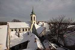 View of Szentendre
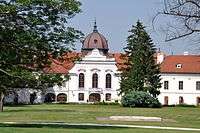 Grassalkovich Palace in Gödöllő
_3.jpg) Citadel of Visegrád
Citadel of Visegrád_2.jpg) Cathedral in Vác
Cathedral in Vác_5.jpg) Zsámbék Premontre monastery church
Zsámbék Premontre monastery church.jpg) Károlyi Mansion, Fót
Károlyi Mansion, Fót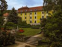 Mailáth Mansion in Törökbálint
 Choral Castle, Pomáz
International relations
Pest County has a partnership relationship with:[8]
|
|
References
- nepesseg.com, population data of Hungarian settlements
- népesség.com, "Pest megye népessége 1870-2015"
- 1.1.6. A népesség anyanyelv, nemzetiség és nemek szerint – Frissítve: 2013.04.17.; Hungarian Central Statistical Office (in Hungarian)
- 2011. ÉVI NÉPSZÁMLÁLÁS, 3. Területi adatok, 3.14 Pest megye, (in Hungarian)
- "Regional GDP per capita ranged from 30% to 263% of the EU average in 2018". Eurostat.
- "Megyei közgyűlés tagjai 2019-2024 (Pest megye)". valasztas.hu. Retrieved 2019-10-29.
- Önkormányzati választások eredményei (in Hungarian)
- Külkapcsolatok (Pest megye)
External links
- Official website

| Authority control |
|
|---|