Vaupés Department
Vaupés (Spanish pronunciation: [bawˈpes]) is a department of Colombia in the jungle covered Amazonas Region. It is located in the southeast part of the country, bordering Brazil to the east, the department of Amazonas to the south, Caquetá to the west, and Guaviare, and Guainía to the north; covering a total area of 54,135 km². Its capital is the town of Mitú.
Department of Vaupés Departamento del Vaupés | |
|---|---|
 Flag  Coat of arms | |
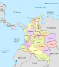
.svg.png) Vaupés shown in red | |
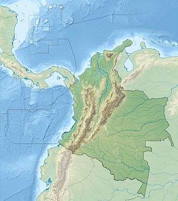
 Topography of the department | |
| Coordinates: 1°12′N 70°10′W | |
| Country | |
| Region | Amazonía Region |
| Established | July 4, 1991 |
| Capital | Mitú |
| Government | |
| • Governor | Jesús Maria Vásquez Caicedo (2016-2019) |
| Area | |
| • Total | 54,135 km2 (20,902 sq mi) |
| Area rank | 7th |
| Population (2018)[3] | |
| • Total | 40,797 |
| • Rank | 32nd |
| • Density | 0.75/km2 (2.0/sq mi) |
| Time zone | UTC-05 |
| ISO 3166 code | CO-VAU |
| Municipalities | 6 |
| HDI (2017) | 0.611[4] medium · 33rd |
| Website | www.vaupes.gov.co |
History
During the colonization by the Spanish and first days of the first republic, the territory of Vaupes was part of the Province of Popayán, during the Greater Colombia. After the independence from Spain between 1821 and 1830 became part of the first version of the Boyacá Department. Between 1831 and 1857 the territory became part of the National Territory of Caquetá to later be part of the Sovereign State of Cauca. In 1886 became part of the then recently created Cauca Department.[5]
With the expansion of the rubber industry and the industrial revolution, exploration for rubber reached the area bringing colonizers that altered and in some cases extinguished the majority of the indigenous population.
The territory was first made into a territorial division in 1910 and functioned as Commissaries (Comisarias) with the town of Calamar as capital (located in present-day Guaviare) but later moved to the town of Mitú to make an "act of presence" near the border with Brasil. In 1963 Guainía segregated from the Vaupes and became a commissary. In 1977, Guaviare followed the same path.
The Department was created after the Colombian Constitution of 1991 which established it as a Department of Colombia on July 4, 1991.[6]
Economy
The department's main economic activities feature logging and fishing, with much exportation to neighboring Brazil.
Demographics
The vast majority of the population consists of indigenous inhabitants.
| Historical population | ||
|---|---|---|
| Year | Pop. | ±% |
| 1973 | 23,250 | — |
| 1985 | 26,178 | +12.6% |
| 1993 | 24,671 | −5.8% |
| 2005 | 39,279 | +59.2% |
| 2018 | 40,797 | +3.9% |
| Source:[7] | ||
Transportation
Because of its location in the Amazon jungle, it has no roads connecting it with the rest of the country or internally from settlement to settlement, and commerce and contact with the outside world is achieved through travel along the main rivers and by means of air travel. Several of the small settlements have airstrips with service to the department's capital, Mitú, and from there with the rest of the country.[8]
Administrative divisions
Because of its small population and vast extension of land, Vaupés only has 3 municipalities. Other sections of the Department were classified as an especial type of Corregimiento, which has certain hybrid functions from a municipality and corregimiento.
Municipal Corregimientos
See also
- Barasana language
- Cubeo language
Notes
- "Nuestro Departamento: Información general". Gobernación del Vaupés. Archived from the original on 2013-02-16. Retrieved 2012-02-12.
- "Vaupés, Department of". Historical Dictionary of Colombia. Scarecrow Press. 2012. p. 291. ISBN 978-0-8108-7813-6.
- "DANE". Archived from the original on November 13, 2009. Retrieved February 13, 2013.
- "Sub-national HDI - Area Database - Global Data Lab". hdi.globaldatalab.org. Retrieved 2018-09-13.
- Vaupes - Capitán Paz
- (in Spanish) Vaupes Secretary of Education; History of Vaupes
- "Reloj de Población". DANE. Departamento Administrativo Nacional de Estadísitica. Retrieved 6 July 2017.
- (in Spanish) Finagro; Vaupes Department
References
- "national lottery on Vaupes" (in Spanish).
- "Encolombia.com - Vaupes" (in Spanish).
- "National Federation of Departments: Vaupes" (in Spanish).
External links
| Gold |
|  |
|---|---|---|
| Silver | ||
| Platinum | ||
| Nickel |
| |
| Coltan | ||
| Emeralds | ||
| Coal |
| |
| Salt | ||
| Sources | ||
 | ||