Buskerud
Buskerud (Urban East Norwegian pronunciation: [ˈbʉ̂skərʉː] (![]()
Buskerud fylke | |
|---|---|
 County Council in Drammen | |
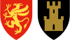
 Flag 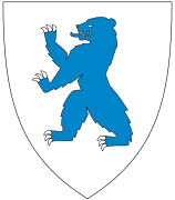 Coat of arms | |
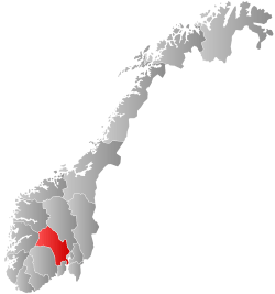 Buskerud within Norway | |
| Coordinates: 60°30′00″N 09°30′00″E | |
| Country | Norway |
| County | Buskerud |
| Region | Østlandet |
| County ID | NO-06 |
| Administrative centre | Drammen |
| Government | |
| • Governor | Kirsti Kolle Grøndahl Arbeiderpartiet (1999–present) |
| • County mayor | Morten Eriksrød Conservative Party (2011–present) |
| Area | |
| • Total | 14,908 km2 (5,756 sq mi) |
| • Land | 13,794 km2 (5,326 sq mi) |
| Area rank | #12 in Norway, 4.53% of Norway's land area |
| Population (30 September 2019) | |
| • Total | 284,955 |
| • Rank | 8 (5.29% of country) |
| • Density | 18/km2 (50/sq mi) |
| • Change (10 years) | 6.7 % |
| Demonym(s) | Buskerudfolk |
| Time zone | UTC+01 (CET) |
| • Summer (DST) | UTC+02 (CEST) |
| Official language form | Neutral |
| Income (per capita) | 155,400 NOK |
| GDP (per capita) | 227,626 NOK (2001) |
| GDP national rank | 7 (3.57% of country) |
| Website | www |
Etymology
The county was named after the old manor Buskerud (Old Norse: Biskupsruð) (Biskopsrøysa) located on the west side of the Drammen River in Åmot, Modum municipality. The first element is the genitive case of biskup, 'bishop' (referring to the Bishop of Hamar), the last element is ruð n 'clearing, farm'. The farm was one of the largest in Buskerud, and the original name of the farm (before it became a benefice) was probably Modum. At the time of the Reformation (c. 1536–39) the farm became property of the Crown at which time the farm then served as the residence of the king's bailiffs until 1668.[3][4][5]
Geography
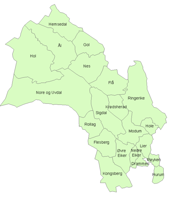
Buskerud extended from Hurum at the Oslofjord to the Halling mountains and Hardanger. The county was conventionally divided into traditional districts. These were Hallingdal, Numedal, Ringerike, Lower Buskerud, which was originally part of Vestfold, and Western Vingulmark.
Hallingdal consisted of Flå, Nes, Gol, Hemsedal, Ål and Hol.[6] Numedal consisted of Flesberg, Rollag and Nore og Uvdal.[7] Ringerike consisted of Hole, Krødsherad, Modum, Ringerike and Sigdal. Western Vingulmark consisted of Hurum and Røyken.[8][9] Lower Buskerud consisted of Drammen, Hurum, Kongsberg, Lier, Nedre Eiker, Røyken and Øvre Eiker. The district was merged from parts that belonged to Vestfold and Vingulmark.[10]
Buskerud's western part was a mountainous plateau with forested valleys and high, grassy pastures; its eastern part contains a lowland basin with many lakes and streams. Tyrifjorden and Krøderen were the biggest lakes. Numedalslågen, the third longest river in Norway, starting in Hordaland, ran through Buskerud unto Vestfold where it reached the sea, while river Begna sweeps into lake Sperillen.
History
Buskerud was separated from Akershus as an amt of its own in 1685, but the amt was smaller than today. It then consisted of the present districts Eiker, Hallingdal, and Ringerike. The area of the present municipalities of Flesberg, Hurum, Kongsberg, Lier, Nore og Uvdal, Rollag and Røyken were transferred from Akershus amt to Buskerud amt in 1760. The name Buskeruds amt was changed to Buskerud fylke in 1919. The municipality of Skoger was transferred from Vestfold to Buskerud in 1964.[14]
The area Ringerike may once have been a small kingdom. During the 10th century, Norway's kings Olaf Tryggvason and Olaf Haraldsson grew up at Bønsnes in Ringerike. In the valley of Numedal, silver was mined in Kongsberg from the 17th century until discontinued in 1957. Weapons industry had been developed in Kongsberg from 1814, and various high tech industry companies now represent the town's major employers. At Modum there was also Blaafarveværket, a cobalt pigment production works (Blue Colour Works).[15]
Economy

Today, agriculture, lumber, wood-pulp mills and other related industries are the county's main economic activities; ample hydroelectric power is produced by the rivers Begna (Begnaelva) and Rands (Randselva) . Buskerud has also a large forested area. Substantial income is derived from high tech industries located in Kongsberg. Other significant income comes from the cabin areas in northern Buskerud.[16][17]
Coat of arms
Buskerud's coat of arms were adopted in April 1966. It features a blue bear whose colours are symbolic of the blue colour works. The silver background of Buskerud's coat of arms represents the silver industry in Kongsberg.
| Number of minorities (1st and 2nd gen.) in Buskerud by country of origin in 2017[18] | |
| Nationality | Population (2017) |
|---|---|
| 8,259 | |
| 2,975 | |
| 2,961 | |
| 2,293 | |
| 1,928 | |
| 1,874 | |
| 1,842 | |
| 1,662 | |
| 1,641 | |
| 1,638 | |
| 1,499 | |
| 1,482 | |
| 1,327 | |
| 1,211 | |
| 1,206 | |
| 1,193 | |
| 1,095 | |
| 1,043 | |
| 1,040 | |
| 956 | |
Notable people from Buskerud
Sports figures
- Frode Andresen, Ringerike
- Christer Basma, Røyken
- Dag Bjørndalen, Modum
- Ole Einar Bjørndalen, Modum
- Håvard Bøkko, Hol
- Kim Christiansen, Drammen
- Ole Gunnar Fidjestøl, Modum
- Tord Asle Gjerdalen, Hole
- Erik Hagen, Ringerike
- Anders Jacobsen, Ringerike
- Jørre Kjemperud, Modum
- Pål Gunnar Mikkelsplass, Nes
- Børre Næss, Kongsberg
- Sigurd Pettersen, Rollag
- Steinar Pettersen, Drammen
- Asbjørn Ruud, Kongsberg
- Birger Ruud, Kongsberg
- Sigmund Ruud, Kongsberg
- Strømsgodset, Gulskogen, Drammen
- Ådne Søndrål, Hol
- Mårk Rude, Buskerud
Other (Musician, TV-Star, TV-Hosts)
Municipalities
| Rank | Name | Inhabitants[19] | Area km2 |
|---|---|---|---|
| 1 | 62,566 | 136 | |
| 2 | 28,806 | 1,437 | |
| 3 | 24,714 | 761 | |
| 4 | 23,267 | 283 | |
| 5 | 22,687 | 116 | |
| 6 | 18,894 | 112 | |
| 7 | 16,616 | 421 | |
| 8 | 12,911 | 468 | |
| 9 | 9,045 | 156 | |
| 10 | 5,976 | 135 | |
| 11 | 4,672 | 1,083 | |
| 12 | 4,479 | 517 | |
| 13 | 4,422 | 1,669 | |
| 14 | 3,514 | 813 | |
| 15 | 3,420 | 776 | |
| 16 | 2,578 | 542 | |
| 17 | 2,514 | 2,281 | |
| 18 | 2,117 | 341 | |
| 19 | 2,087 | 715 | |
| 20 | 1,390 | 484 | |
| 21 | 998 | 674 | |
| Total | 257,673 | 12,336 |
Districts
- Eiker
- Eggedal
- Hallingdal
- Hurumlandet
- Jondalen
- Numedal
- Ringerike
- Lower Buskerud
- Kjenner
- Klokkarstua
Parishes
- Bakke
- Bragernes
- Dagali
- Drammen
- Efteløt
- Eggedal
- Eiker
- Fiskum
- Flesberg
- Flå
- Frogner
- Gol
- Haug, see Eiker
- Haug i Norderhov
- Hedenstad
- Heggen
- Hemsedal
- Hol
- Hole
- Holmen
- Holmsbu
- Hurum
- Hval
- Hønefoss
- Jondalen
- Komnes
- Kongsberg
- Krødsherad (Krydsherred)
- Lier
- Lunder
- Lyngdal
- Modum
- Nedre Eiker
- Nes (i Hallingdal)
- Nes (i Ådal)
- Norderhov
- Nore
- Nykirke
- Opdal
- Rollag
- Røyken
- Sandsvær
- Sigdal (Holem)
- Snarum
- Sollihøgda
- Strømsø
- Svene
- Sylling
- Tangen
- Torpo
- Tranby
- Tuft
- Tyristrand
- Uvdal
- Veggli
- Viker
- Ytre Ådal
- Ådal
- Ål
- Drammen Branch (LDS, 1854-1952)
- Drammen (Den Katolske Apostoliske Menighet, 1877-1935)
- Drammen and Oslo (Den Katolske Apostoliske Menighet, 1872-1932)
- Hurum Branch (LDS, 1855-1867)
- Kongsberg Branch (LDS, 1939-1948* )
Villages
- Ask
- Askgrenda
- Burud
- Bødalen
- Båtstø
- Dagali
- Dagslett
- Darbu
- Dramdal
- Drolsum
- Efteløt
- Egge
- Filtvet
- Gardnos
- Geilo
- Geithus
- Gomnes
- Gulsvik
- Hagafoss
- Hallingby
- Haugastøl
- Haugsbygd
- Helgelandsmoen
- Hen
- Hennummarka
- Holmsbu
- Hovet
- Hønefoss
- Hval
- Hvittingfoss
- Hyggen
- Kjenner
- Klokkarstua
- Konnerud
- Krokstadelva
- Kroksund
- Krøderen
- Kvisla
- Lahell
- Lampeland
- Lierbyen
- Lierskogen
- Lierstranda
- Mjøndalen
- Midtbygda
- Nakkerud
- Nedre Eggedal
- Nes, Ådal
- Nesbyen
- Nore
- Noresund
- Nærsnes
- Oddevall
- Ormåsen
- Ovenstadlia
- Prestfoss
- Reistad
- Rollag
- Rødberg
- Sjåstad
- Skoger
- Skollenborg
- Skotselv
- Slemmestad
- Sokna
- Solbergelva
- Sollihøgda
- Spikkestad
- Steinberg
- Steinsåsen
- Storsand
- Sundvollen
- Svene
- Sylling
- Sysle
- Sætre
- Tofte
- Torpo
- Tronstad
- Tyristrand
- Ustaoset
- Uvdal
- Veggli
- Vestbygda
- Vestfossen
- Vik
- Vikersund
- Åmot
- Åros
- Åsa
- Åsbygda
Former Municipalities
Gallery
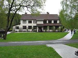 Blaafarveværket in Modum
 Hokksund Station
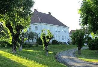 Frogner Rectory in Lier
 Hønefoss Church in Ringerike, burned down 2007.
References
- Geir Thorsnæs. "Buskerud". Store norske leksikon. Retrieved February 5, 2016.
- "Prop. 84 S". Norwegian Government. Retrieved 22 January 2018.
- Einar Sørensen. "Buskerud gård på Modum". historieboka. Archived from the original on March 7, 2016. Retrieved February 5, 2016.
- Geir Thorsnæs. "Buskerud hovedgård". Store norske leksikon. Retrieved February 5, 2016.
- "Buskerud, Modum herad". Matrikkelutkastet av 1950. Retrieved February 5, 2016.
- Geir Thorsnæs. "Hallingdal". Store norske leksikon. Retrieved February 5, 2016.
- Geir Thorsnæs. "Numedal". Store norske leksikon. Retrieved February 5, 2016.
- Per G. Norseng. "Vestfold – gammelt navn". Store norske leksikon. Archived from the original on October 18, 2016. Retrieved February 5, 2016.
- Svein Askheim. "Vingulmark". Store norske leksikon. Retrieved February 5, 2016.
- Munch, Peter Andreas (1849). Historisk-geographisk beskrivelse over kongeriget Norge (Noregsveldi) i middelalderen. W. Gram. pp. 5–7.
- Projected population - Statistics Norway
- Statistics Norway - Church of Norway.
- Statistics Norway - Members of religious and life stance communities outside the Church of Norway, by religion/life stance. County. 2006-2010 Archived November 2, 2011, at the Wayback Machine
- Geir Thorsnæs. "Ringerike, Hallingdal, Eiker og Buskeruds amt". Store norske leksikon. Retrieved February 5, 2016.
- Ingolf Jarle Rui. "Modum Blaafarveværk". Store norske leksikon. Retrieved February 5, 2016.
- Geir Thorsnæs. "Begna". Store norske leksikon. Retrieved February 5, 2016.
- Asbjørn Vinjar. "Randselva". Store norske leksikon. Retrieved February 5, 2016.
- "Immigrants and Norwegian-born to immigrant parents, by immigration category, country background and percentages of the population". ssb.no. Retrieved 3 August 2017.
- Statistisk Sentralbyrå (1 January 2010). "www.ssb.no".
External links
| Wikivoyage has a travel guide for Buskerud. |
| Wikimedia Commons has media related to Buskerud. |
 |  | ||||||||||||||||||||||||||||||||||||||||
|
| |||||||||||||||||||||||||||||||||||||||||||||||||||||||||||||||||||||