Waitaki District
Waitaki District is a territorial authority that is located in the Canterbury and Otago regions of the South Island of New Zealand. It straddles the traditional border between the two regions, the Waitaki River.
Waitaki District | |
|---|---|
 Waitaki District Council building, Thames Street, Oamaru | |
 Coat of arms | |
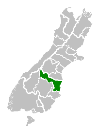 Location of the Waitaki District within the South Island | |
| Country | New Zealand |
| Regions |
|
| District | Waitaki District Council |
| Wards | Ahuriri Corriedale Oamaru Waihemo |
| Formed | 1989 |
| Seat | Oamaru |
| Towns | |
| Government | |
| • Mayor | Gary Kircher [1] |
| • Deputy Mayor | Melanie Tavendale |
| • Electorate | Waitaki |
| Area | |
| • Total | 7,148.05 km2 (2,759.88 sq mi) |
| Population (June 2019)[2] | |
| • Total | 23,200 |
| • Density | 3.2/km2 (8.4/sq mi) |
| Time zone | UTC+12 (NZST) |
| • Summer (DST) | UTC+13 (NZDT) |
| Postcode(s) | |
| Postcode(s) | 7977 |
| Area code(s) | 03 |
| Website | Waitaki District Council |
History
Waitaki District is made up of the former Waitaki County, Waihemo County and Oamaru Borough, which were amalgamated in 1989. It is governed by the Waitaki District Council.
Name
During the colonial period, the area was also known as Molesworth[3], however the Maori name Waitaki eventually prevailed.
Geography
It has a land area of 7,151.94 km² (2,761.38 sq mi), of which 59.28% is in the Canterbury Region and 40.72% in the Otago Region. It is the only district in the South Island that lies in two regions. A major reason for this split was the governance of the Waitaki River which forms a political boundary between Canterbury and Otago. With major hydro schemes on this river it was decided to place the entire catchment in one administrative region, thus forming the split. Some people who fall into the Canterbury Region of Waitaki District still regard themselves as part of Otago, and attempts have been made in the past to change the boundary. The district, which is agricultural by nature, comprises the wide alluvial fan of the river, and runs inland along the banks of the river, forming a roughly triangular region.
Demographics
| Historical population | ||
|---|---|---|
| Year | Pop. | ±% p.a. |
| 2006 | 20,223 | — |
| 2013 | 20,829 | +0.42% |
| 2018 | 22,308 | +1.38% |
| Source: [4] | ||
Waitaki District had a population of 22,308 at the 2018 New Zealand census, an increase of 1,479 people (7.1%) since the 2013 census, and an increase of 2,085 people (10.3%) since the 2006 census. There were 9,171 households. There were 10,974 males and 11,331 females, giving a sex ratio of 0.97 males per female. Of the total population, 4,071 people (18.2%) were aged up to 15 years, 3,348 (15.0%) were 15 to 29, 9,819 (44.0%) were 30 to 64, and 5,070 (22.7%) were 65 or older. Figures may not add up to the total due to rounding.
Ethnicities were 88.0% European/Pākehā, 8.2% Māori, 3.8% Pacific peoples, 5.3% Asian, and 1.9% other ethnicities. People may identify with more than one ethnicity.
The percentage of people born overseas was 15.4, compared with 27.1% nationally.
Although some people objected to giving their religion, 47.9% had no religion, 41.5% were Christian, and 3.1% had other religions.
Of those at least 15 years old, 2,331 (12.8%) people had a bachelor or higher degree, and 4,719 (25.9%) people had no formal qualifications. The median income was $27,700. The employment status of those at least 15 was that 8,529 (46.8%) people were employed full-time, 2,826 (15.5%) were part-time, and 441 (2.4%) were unemployed.[4]
Populated places
Waitaki District includes the following towns, localities, settlements and communities:
|
|
Population
Waitaki District's population is 23,200 (June 2019).[2] Of this, 13,150 (57%) live in Oamaru, the district seat, in Otago.
Economy
A relatively sparsely settled area, the District has a large number of farms. However, in recent times (late 2000s), numerous proposals for new farming operations have locals fearing that the agriculture will be transformed from often family-held farms to large agribusiness operations causing local ecological damage and siphoning off capital overseas.[5]
References
- "Council (Waitaki District Council)". Waitaki.govt.nz. Retrieved 30 January 2016.
- "Subnational Population Estimates: At 30 June 2019". Statistics New Zealand. 22 October 2019. Retrieved 11 January 2020.
- "What's In A Name? Geographic Board's Work". Evening Post. 27 April 1934. Retrieved 24 June 2018.
- "Statistical area 1 dataset for 2018 Census". Statistics New Zealand. March 2020. Waitaki District (068). 2018 Census place summary: Waitaki District
- Taylor, Gary (8 February 2010). "A national treasure is being squandered". The New Zealand Herald. Retrieved 8 February 2010.