Dumka
Dumka, the headquarters of the Dumka district and Santhal Pargana region, is a city in the state of Jharkhand, India. It was made the headquarters of the Santhal Pargana region, which was carved out of the Bhagalpur and Birbhum district after the Santal Hool of 1855. Dumka was carved out of the southern part of Bihar along with 18 other Districts on 15 November 2000 to form Jharkhand as 28th State of India. Dumka is a peaceful and green city and also sub-capital of Jharkhand. The nearest important cities are Rampurhat and Deoghar.
Dumka | |
|---|---|
Town | |
 Dumka Location in Jharkhand, India  Dumka Dumka (India) | |
| Coordinates: 24.27°N 87.25°E | |
| Country | |
| State | Jharkhand |
| District | Dumka |
| Region | Rarh region |
| Government | |
| • Type | Municipality |
| • Member of Parliament, Lok Sabha | Sunil Soren (BJP) |
| • Member of Legislative Assembly, Jharkhand | Vacant |
| Area | |
| • Total | 4,404.02 km2 (1,700.40 sq mi) |
| Elevation | 137 m (449 ft) |
| Population (2011) | |
| • Total | 47,584 |
| • Density | 300/km2 (800/sq mi) |
| Languages | |
| • Official | Hindi, Santali |
| • Other important | Bengali |
| Time zone | UTC+5:30 (IST) |
| PIN | 814101 |
| Telephone code | 06434 |
| Vehicle registration | JH-04 |
| Sex ratio | 974 ♂/♀ |
| Website | dumka |
Etymology
There are two theories on how Dumka got its name. The first one suggests that Dumka's name derives from the Santali word sumk for "shunted" or "small," because during the British Raj, it was a small town compared to Rampurhat and Bhagalpur .
The other is that Dumka derives its name from the Persian word damin-i-koh, which means 'skirts (an edge, border or extreme part) of the hills'. The Mughals assigned this name to the town and its vicinity on account of the presence of hillocks and undulating terrain.
History
- Early History: The earlier inhabitants of the present-day district of whom there is some record, it appears, were the Paharias (for example, the Maler and Sauria Paharias). The Greek traveler Megasthenes identified these people as Mallis. He referred to the Sauria Paharias as savars of Odisha.
- Medieval History: Due to inaccessibility of the area caused by the cliffs of the Rajmahal Hills, it was a place of strategic economic importance, with a fort at Teliagarhi.
- After the 1539 victory of Sher Shah Suri at Chousa, the area fell into the hands of the Afghans, but it was soon lost to the Mughals under Akbar when Hussain Quli Khan was made viceroy of Bengal.
- British Period (Raj): The English representative, Dr. Gabriel Bokgliton, procured a farman from Shah Jahan.
- 1742-1751: The area of Dumka close to Rajmahal witnessed frequent inroads by the Marathas under Raghoji Bhosle and Peshwa Balaji Rao.
- 1745: Raghoji Bhosle entered Rajmahal via the hills and jungles of Santal Pargana. The early stay of the English was spent in subduing the Paharias.
- 1769: Dumka remained a Ghatwali police post under Birbhum District of Bengal.
- 1775: Dumka was transferred to Bhagalpur Division.
- 1865: Dumka was made an independent district after being carved out of Bhagalpur.
- 1872: Dumka was made headquarters of the whole district of Santal Pargana.
- 1889: Paul Olaf Bodding started his service in India (Dumka/Benagaria) after Lars Olsen Skrefsrud, and Bodding created the first alphabet for the Santhals. The NELC-church was created as a Lutheran Church in this area - before the Catholics had established a mission in this area at all.
- 1902: The first municipality was established.
1920: Motor cars and buses were introduced.
- 1952: The Apostolic Prefecture of Malda was erected. In 1962, it was promoted to the Roman Catholic Diocese of Dumka.
- 1983: Dumka was made the divisional headquarters of Santhal Pargana.
- 2000: Dumka became the sub-capital of Jharkhand.
- 2011: Dumka is connected with the newly built Jasidih-Dumka railway line.
- 2012: Intercity express to Ranchi started via Jasidih.
- 2017: Jharkhand opens pilot training center in Dumka.
- 2018: Full 4-lane road from Dudhani to Tata Showroom constructed.
Population
Demographics
As of 2011 India census,[1] Dumka is a Nagar Parishad city in district of Dumka, Jharkhand. The Dumka city is divided into 23 wards for which elections are held every 5 years. The Dumka Nagar Parishad has population of 47,584 of which 25,364 are males while 22,220 are females as per report released by Census India 2011.
Population of children with age of 0-6 is 5371 which is 11.29% of total population of Dumka (Nagar Parishad). In Dumka Nagar Parishad, Female Sex Ratio is of 876 against state average of 948. Moreover, Child Sex Ratio in Dumka is around 891 compared to Jharkhand state average of 948. Literacy rate of Dumka city is 89.92% higher than state average of 66.41%. In Dumka, Male literacy is around 93.46% while female literacy rate is 85.87%.
Religion, languages and culture
Dumka District contains many popular Hindu temples, such as Basukinath, Sirshanath, Maluti Mandir, Shiv Pahar and Dharamsthana. Crowds visit these places during the month of Sawan.
Chootonath is also a very famous place of local KRAM KAND and MUNDAN.
The Catholic minority is served by its own Roman Catholic Diocese of Dumka.
Besides the national official language Hindi, Santali and Bengali are important.
Geography
Dumka is located at 24.27°N 87.25°E.[2] It has an average elevation of 137 metres (449 feet). The Dumka district has an area of 3716.02 km2 and consists of only one subdivision, namely, Dumka. Under the Dumka subdivision, there are 10 blocks, namely, Dumka, Gopikander, Jama, Jarmundi, Kathikund, Maslia, Ramgarh, Ranishwar, Shikaripara and Saraiyahat.
Places adjacent to Dumka | |
|---|---|
Physiography
Dumka has a predominantly undulating terrain with hard rocks under the ground. The entire district has a topography with high ridges and valleys bounded by mountains and rivers. The soil fertility is poor due to extensive erosion, acidity and low retaining capacity.
Climate
Dumka has a humid subtropical climate (Köppen climate classification Cwa), with warm, wet summers and mild winters.
| Climate data for Dumka | |||||||||||||
|---|---|---|---|---|---|---|---|---|---|---|---|---|---|
| Month | Jan | Feb | Mar | Apr | May | Jun | Jul | Aug | Sep | Oct | Nov | Dec | Year |
| Record high °C (°F) | 33.3 (91.9) |
35.6 (96.1) |
42.8 (109.0) |
46.3 (115.3) |
48.3 (118.9) |
45.2 (113.4) |
41.5 (106.7) |
38.6 (101.5) |
38.1 (100.6) |
37.6 (99.7) |
35.8 (96.4) |
31.2 (88.2) |
48.3 (118.9) |
| Average high °C (°F) | 25.9 (78.6) |
28.9 (84.0) |
34.3 (93.7) |
38.4 (101.1) |
37.5 (99.5) |
35.5 (95.9) |
32.7 (90.9) |
32.5 (90.5) |
32.9 (91.2) |
33.0 (91.4) |
30.5 (86.9) |
27.0 (80.6) |
32.4 (90.4) |
| Average low °C (°F) | 10.2 (50.4) |
13.2 (55.8) |
17.4 (63.3) |
22.3 (72.1) |
23.9 (75.0) |
24.7 (76.5) |
24.1 (75.4) |
23.7 (74.7) |
23.6 (74.5) |
21.0 (69.8) |
16.0 (60.8) |
11.1 (52.0) |
19.3 (66.7) |
| Record low °C (°F) | 1.7 (35.1) |
1.8 (35.2) |
5.8 (42.4) |
13.8 (56.8) |
14.5 (58.1) |
17.8 (64.0) |
13.4 (56.1) |
16.8 (62.2) |
13.8 (56.8) |
11.8 (53.2) |
4.8 (40.6) |
2.8 (37.0) |
1.7 (35.1) |
| Average precipitation mm (inches) | 9.0 (0.35) |
15.0 (0.59) |
21.0 (0.83) |
35.0 (1.38) |
72.0 (2.83) |
198.0 (7.80) |
343.0 (13.50) |
293.0 (11.54) |
273.0 (10.75) |
116.0 (4.57) |
9.0 (0.35) |
7.0 (0.28) |
1,391 (54.77) |
| Average rainy days | 1.5 | 2.3 | 2.2 | 2.8 | 6.3 | 11.3 | 18.9 | 16.9 | 14.1 | 5.7 | 1.1 | 0.8 | 83.9 |
| Average relative humidity (%) | 60 | 53 | 47 | 50 | 60 | 73 | 83 | 83 | 81 | 74 | 65 | 62 | 66 |
| Source: NOAA (1971-1990)[3] | |||||||||||||
Politics
The first Chief Minister of Jharkhand, Babulal Marandi, hailed from Dumka constituency. In 2000, when Jharkhand was carved out of Bihar, NDA came to power in Jharkhand with Marandi as the Chief Minister. However, he had to resign and make way for Arjun Munda (BJP) for the post in 2002 following pressure exerted by coalition allies primarily JD(U). Recently, he formed his own party with Stephan Marandi, another political leader of the state.
Shibu Soren is another politician associated with Dumka. His political career has been mired in controversies, starting since Indira Gandhi's prime ministership. Recently, he was sent to Dumka jail after being convicted of murdering his private secretary Shashinath Jha. But, the Delhi High Court acquitted him of the murder charge of his private secretary due to lack of evidence. A number of cases are still pending before the Jamtara Session Court and some of the other courts of the Jharkhand. He is currently holding the place of MP from Dumka constituency, while his son Hemant Soren was representing Dumka in the Legislative Assembly and is deputy CM of the state.
In 2014, state election BJP coalition got majority in Assembly and Raghubar Das become the Chief Minister of Jharkhand, another politician associated with Jamsedhpur.
Education
There are various higher secondary schools in Dumka, i.e. Sido Kanhu High School, Zila School, National School, Govt. Girls School and Dumka Central School. Some reputed schools which provide secondary level education are North Valley International School[4], St. Joseph's High School, Bal Bharti and others include Ananda Marg School (Kurwa), Modern Sainik School, Green Mount Academy and New Life Academy at Kathikund.
For higher education Dumka offers many colleges e.g.- Sido Kanhu Murmu University was established in 1992 at Dumka and covers whole Santhal Pargana. Many colleges are affiliated or constituent to SKMU in the division.
St. Xavier's College, Dumka is best college in the city and offers various courses. Others include Santhal Pargana College, A.N. College, S. P. College and S.P Mahila College who offers undergraduate, graduate & post graduate courses here.
Phulo-Jhano Murmu College of Dairy Technology at Hansdiha, Dumka is Jharkhand's first Dairy Technology college established in 2019.[5] It is affiliated by Birsa Agricultural University, Ranchi.
GTRTC, Dumka (Government Tool Room and Training Centre) has been established in 2007 by the Department of Industries, Government of Jharkahnd with the assistance of Ministry of MSME, Government of India.[6] It offers various training programmes to meet the wide spectrum of technical manpower required in the manufacturing sector. Lahanti Institute of Multiple Skills was established by Evangelical Social Action Forum to provide skills training to unemployed youth in the remote regions of Santhal Pargana.[7] Dumka also have a Govt. Polytechnic College, a Govt. Women's Polytechnic College and also a govt. ITI for technical education.
Dumka Engineering College was established as an institution under PPP model between the Government of Jharkhand and Techno India Group.[8]
Dumka Medical College was established in 2019 and it also contains hospitals for serving population of Dumka.[9]
Tourist places
Basukinath
Maluti temple village
Maluti is an ancient temple village of Dumka District under Shikaripara police station. it is located near the border of West Bengal and Jharkhand State. Lots of Shiva, Bishnu, Durga Terracotta temples are there.
Maluti temple gallery
 Maluti teracotta temple
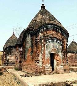 Maluti Temple
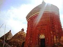 Malooti mandir
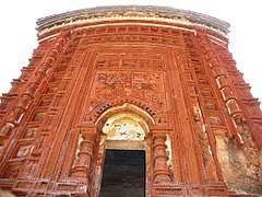 Malooti mandir
 Malooti mandir
 Malooti mandir
 Malooti mandir
 Malooti mandir
Masanjore Dam
| Wikivoyage has a travel guide for Massanjore. |
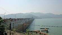
Masanjore is a picnic spot situated 30 km to the Dumka town in Dumka District of Jharkhand. This small village is about 30 km south of Dumka. The Masanjore dam on the Mayurakshi River is a major draw. From the counterpart rupee fund created through supplies of wheat and other materials from Canada for use in India, Canada Govt. devoted those funds to further development of the Mayurakshi project and Masanjore dam was commissioned in 1955. That's why the Dam is still mentioned as Canada Dam. The dam is bounded by hills and forests. Mayurakshi Bhawan Bungalow and Inspection Bungalow, offer accommodation within the village. By road, Masanjore is connected with Vakreshwara (59 km), Sainthia (50 km), Tarapith (70 km), Rampurhat (62 km) and Deoghar (98 km).
Kurwa park (Shrishti)
It is a small picnic spot about 5 km to the east of Dumka. It has a park, facilities for boating and a small hill.
Chutonath
It is situated 20 km from the district headquarters. Chutonath is a religious place of Hindu god Lord Chutonath. This festival is celebrated mainly in the month of April. This area has become a tourist attraction.
Dharmasthan
It is temple situated in Tin bazaar at the heart of Dumka Town, it is known for the Goddess Kali, during the Durga puja 7 days special puja is organised here.
MALLS
There are six malls all-together in Dumka.
- V-Mart: This is first mall to be opened in Dumka and this is situated in Veer Kunwar Singh Chowk, Dumka.
- M-Baazar: This is situated below Hotel Suvidha.
- 1-India Family Mart: This is situated in Thana Road, Dumka.
- Bazaar India: This is situated in bhagalpur road, Dumka just beside Punjab National Bank.
- V2: This is situated just opposite to 1-India Family Mart in Thana road, Dumka.
- Reliance Trends: This is mall in Dumka district which opened on 5 August 2019. This is situated in Jail Road, Dumka, opposite to Mary filling station.
Transport
Rail
[]
Jasidih–Dumka–Rampurhat line | |||||||||||||||||||||||||||||||||||||||||||||||||||||||||||||||||||||||||||||||||||||||||||||||||||||||||||||||||||||||||||||||||||||||||||||||||||||||||||||||||||||||||||||||||||||||||||||||||||||||||||||||||||||||||||||||||||||||||||||||||||||||||||||||||||||||||||||||||||||||||||||||||||||||||||||||||||||||||||||||||||||||||||||||||||||||||||||||
|---|---|---|---|---|---|---|---|---|---|---|---|---|---|---|---|---|---|---|---|---|---|---|---|---|---|---|---|---|---|---|---|---|---|---|---|---|---|---|---|---|---|---|---|---|---|---|---|---|---|---|---|---|---|---|---|---|---|---|---|---|---|---|---|---|---|---|---|---|---|---|---|---|---|---|---|---|---|---|---|---|---|---|---|---|---|---|---|---|---|---|---|---|---|---|---|---|---|---|---|---|---|---|---|---|---|---|---|---|---|---|---|---|---|---|---|---|---|---|---|---|---|---|---|---|---|---|---|---|---|---|---|---|---|---|---|---|---|---|---|---|---|---|---|---|---|---|---|---|---|---|---|---|---|---|---|---|---|---|---|---|---|---|---|---|---|---|---|---|---|---|---|---|---|---|---|---|---|---|---|---|---|---|---|---|---|---|---|---|---|---|---|---|---|---|---|---|---|---|---|---|---|---|---|---|---|---|---|---|---|---|---|---|---|---|---|---|---|---|---|---|---|---|---|---|---|---|---|---|---|---|---|---|---|---|---|---|---|---|---|---|---|---|---|---|---|---|---|---|---|---|---|---|---|---|---|---|---|---|---|---|---|---|---|---|---|---|---|---|---|---|---|---|---|---|---|---|---|---|---|---|---|---|---|---|---|---|---|---|---|---|---|---|---|---|---|---|---|---|---|---|---|---|---|---|---|---|---|---|---|---|---|---|---|---|---|---|---|---|---|---|---|---|---|---|---|---|---|---|---|---|---|---|---|---|---|---|---|---|---|---|---|---|---|---|---|---|---|---|---|---|---|
| |||||||||||||||||||||||||||||||||||||||||||||||||||||||||||||||||||||||||||||||||||||||||||||||||||||||||||||||||||||||||||||||||||||||||||||||||||||||||||||||||||||||||||||||||||||||||||||||||||||||||||||||||||||||||||||||||||||||||||||||||||||||||||||||||||||||||||||||||||||||||||||||||||||||||||||||||||||||||||||||||||||||||||||||||||||||||||||||
However, in July 2011, Dumka was connected to Jasidih with the newly built Jasidih - Dumka railway line. Since then, the city has seen a growing number of three-wheelers on the road. in June 2015, Dumka Rampurhat Train service is also started.
Road
Dumka is connected by road to the neighboring cities such as Deoghar, Bhagalpur, Dhanbad, Rampurhat. Buses are the preferred mode of transport and are run by both government agencies and private operators. Dumka has good connectivity to neighboring districts with buses. There is a luxury night bus service between Dumka - Ranchi and Kolkata. The road network of Dumka is very well maintained.
See also
- Dumka District
- Jharkhand
References
- "Dumka Population Census 2011". Census Commission of India. Retrieved 20 July 2017.
- Falling Rain Genomics, Inc - Dumka
- "Dumka Climate Normals 1971-1990". National Oceanic and Atmospheric Administration. Retrieved 22 December 2012.
- "North Valley International School". www.northvalleyinternationalschool.com. Retrieved 16 January 2020.
- "Guv to inaugurate Phulo-Jhano Dairy Technology College on August 19 - Reporter Post". reporterpost.in. Retrieved 16 January 2020.
- "GTRTC Dumka". www.gtrtcdumka.com. Retrieved 16 January 2020.
- Pioneer, The. "Skilling the remote part of India". The Pioneer. Retrieved 16 January 2020.
- "Dumka Engineering College". www.dumkaengg.edu.in. Retrieved 16 January 2020.
- "300 MBBS seats added in Jharkhand as SC gives nod to 3 new medical colleges". Hindustan Times. 21 August 2019. Retrieved 16 January 2020.
Further reading
- Verma, K. K., Alvi, N. M., Lal, B. B., & India. (1981). Special survey reports on selected towns: Series 4. Delhi: Controller of Publications.