Carmen, Agusan del Norte
Carmen, officially the Municipality of Carmen (Cebuano: Lungsod sa Carmen; Tagalog: Bayan ng Carmen), is a 4th class municipality in the province of Agusan del Norte, Philippines. According to the 2015 census, it has a population of 20,839 people.[4]
Carmen | |
|---|---|
| Municipality of Carmen | |
 Municipal Hall | |
 Seal | |
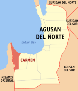 Map of Agusan del Norte with Carmen highlighted | |
OpenStreetMap 
| |
.svg.png) Carmen Location within the Philippines | |
| Coordinates: 9°00′N 125°16′E | |
| Country | |
| Region | Caraga (Region XIII) |
| Province | Agusan del Norte |
| District | 2nd district |
| Founded | July 1, 1949 |
| Barangays | 8 (see Barangays) |
| Government | |
| • Type | Sangguniang Bayan |
| • Mayor | Jovitte C. Calo |
| • Vice Mayor | Ramon M. Calo |
| • Congressman | Ma. Angelica Rosedell A. Matba |
| • Electorate | 14,792 voters (2019) |
| Area | |
| • Total | 311.02 km2 (120.09 sq mi) |
| Elevation | 11.0 m (36.1 ft) |
| Population (2015 census)[4] | |
| • Total | 20,839 |
| • Density | 67/km2 (170/sq mi) |
| • Households | 4,628 |
| Economy | |
| • Income class | 4th municipal income class |
| • Poverty incidence | 36.35% (2015)[5] |
| • Revenue (₱) | 84,144,633.96 (2016) |
| Time zone | UTC+8 (PST) |
| ZIP code | 8603 |
| PSGC | |
| IDD : area code | +63 (0)85 |
| Climate type | tropical rainforest climate |
| Native languages | Agusan language Butuanon Cebuano Higaonon Tagalog |
| Website | www |
Geography
According to the Philippine Statistics Authority, the municipality has a land area of 311.02 square kilometres (120.09 sq mi) [2] constituting 11.39% of the 2,730.24-square-kilometre- (1,054.15 sq mi) total area of Agusan del Norte.
Carmen is strategically located in the Western Agusan Corridor. It is bounded on the north by the Butuan Bay, south by Buenavista, east by Nasipit and west by Misamis Oriental. Its rolling hills are planted with different kinds of orchard, where some 500 hectares (1,200 acres) are devoted solely to mango plantations. About half of these are fully developed and are already producing sweet mango fruits which are being sold in volume in Cebu and Manila and to neighboring municipalities and Butuan City.
Barangays
Carmen is politically subdivided into 8 barangays.[6]
| PSGC | Barangay | Population | ±% p.a. | |||
|---|---|---|---|---|---|---|
| 2015[4] | 2010[7] | |||||
| 160204001 | Cahayagan | 11.5% | 2,395 | 2,380 | 0.12% | |
| 160204002 | Gosoon | 8.7% | 1,806 | 1,772 | 0.36% | |
| 160204004 | Manoligao | 6.5% | 1,356 | 1,513 | −2.06% | |
| 160204009 | Poblacion (Carmen) | 28.7% | 5,988 | 5,507 | 1.61% | |
| 160204010 | Rojales | 12.2% | 2,542 | 2,083 | 3.86% | |
| 160204011 | San Agustin | 5.7% | 1,183 | 1,117 | 1.10% | |
| 160204012 | Tagcatong | 16.6% | 3,462 | 3,382 | 0.45% | |
| 160204014 | Vinapor | 10.1% | 2,107 | 2,027 | 0.74% | |
| Total | 20,839 | 19,781 | 1.00% | |||
Climate
| Climate data for Carmen, Agusan del Norte | |||||||||||||
|---|---|---|---|---|---|---|---|---|---|---|---|---|---|
| Month | Jan | Feb | Mar | Apr | May | Jun | Jul | Aug | Sep | Oct | Nov | Dec | Year |
| Average high °C (°F) | 27 (81) |
28 (82) |
28 (82) |
30 (86) |
30 (86) |
30 (86) |
30 (86) |
30 (86) |
30 (86) |
30 (86) |
29 (84) |
28 (82) |
29 (84) |
| Average low °C (°F) | 23 (73) |
23 (73) |
23 (73) |
23 (73) |
24 (75) |
25 (77) |
24 (75) |
25 (77) |
25 (77) |
24 (75) |
24 (75) |
24 (75) |
24 (75) |
| Average precipitation mm (inches) | 277 (10.9) |
211 (8.3) |
155 (6.1) |
109 (4.3) |
166 (6.5) |
191 (7.5) |
154 (6.1) |
138 (5.4) |
127 (5.0) |
173 (6.8) |
241 (9.5) |
231 (9.1) |
2,173 (85.5) |
| Average rainy days | 22.7 | 19.1 | 20.0 | 19.9 | 25.9 | 27.6 | 27.6 | 26.1 | 25.1 | 26.8 | 24.3 | 23.2 | 288.3 |
| Source: Meteoblue (Use with caution: this is modeled/calculated data, not measured locally.) [8] | |||||||||||||
History
The first Christian settlers of Kabayawa village (now Carmen) was the family of Fulgencio Loque and Demetria Mamba from Jagna, Bohol... in the early 1900s. The family encounters of the natives... Manobo/Higaonon tribes of Mankalasi clan was not that difficult as the natives were friendly. Day to day's trade was done through a Barter System... wherein goods and services were directly exchanged for other goods and services without using any money... and through this “system”, parcels of lands were also being acquired.
In early days, parcel of land corners were planted with a Moringa tree to mark and determines its boundaries... which was later replaced with concrete pin or “mojon” when the Spanish authorities assume control of the village.
The news of abundance then spread among the siblings and extended families of the new settlers, resulting in an influx of newcomers. The Loque's and Mamba's settled in the now poblacion... while the extended families in the adjoining areas to the east, west and south of poblacion like; the Pacon, the Quesaba, the Honcolada, the Malimit, and others. Farther west the Rojales and the Jamito. While the Ebarle, the Jamero, the Sajor and the Salas in Tagcatong, and the Balmoceda in Goso-on.
Carmen got its present name from the miraculous image of the Virgin of Mount Carmen, believed to have been instrumental in killing the leader of the bandits who used to inhabit the place.
A Spanish Soldier named Juan Cardoniga was supposed to have fired his rifle at the leader of the outlaws who possessed an amulet of some source. Since his rifle did not work, Cardoniga got the image of the virgin from his necklace and place it inside the hole of the barrel after which he succeeded in firing the rifle and in killing the outlaw chief.
It was Rev. Saturnino Urios, the famous Jesuit priest of Agusan, who suggested that the name Kabayawa be changed to Carmen in honor of the secret image.
Carmen was created into a municipality in 1949, when the barrios of Carmen, Tagcatong, Cahayagan and San Agustin were separated from the municipality of Nasipit and constituted into the newly created town, by virtue of Republic Act No. 380 which was approved on June 15, 1949.[9] This law was sponsored by Congressman Marcos M. Calo. The town came into being on July 1, 1949.
Demographics
| Population census of Carmen | |||||||||||||||||||||||||||||||||||||
|---|---|---|---|---|---|---|---|---|---|---|---|---|---|---|---|---|---|---|---|---|---|---|---|---|---|---|---|---|---|---|---|---|---|---|---|---|---|
|
| ||||||||||||||||||||||||||||||||||||
| Source: Philippine Statistics Authority[4][7][10][11] | |||||||||||||||||||||||||||||||||||||
In the 2015 census, Carmen had a population of 20,839.[4] The population density was 67 inhabitants per square kilometre (170/sq mi).
Local government
Elected government officials of Carmen for the term of 2016-2019:
- Mayor: Ramon "Monching RMC" M. Calo
- Vice Mayor: Wilfredo T. Taglucop
- Sangguniang Bayan:
- Eva D. Palarca
- Maria Riza P. Ledesma
- Diosdado R. Palang-at
- Gilda A. Samaco
- Abraham Dela Cruz Jr.
- Julius Tamayo
- Corazon Alpuerto
- Jan Ledesma
- SB Secretary:
- Felomino Palisan Jr.
List of former mayors
- Honculada, Nicanor O. - 1949–1951
- De Guzman, Arturo - 1952–1955
- Malimit, Jose - 1956–1960, 1964-1967
- Degamo, Esteban - 1960–1963
- Calo, Tranquilino Jr. - 1968–1969, 1972-1985, 1988-1993
- Campos, Ernesto - 1969–1971
- Pacon, Dionesio - 1986–1987
- Aparecio, Joaquin - 1987
- Battad, Arnulfo - 1987 - 1988 (until January only)
- Luneta, Eliseo - 1993–1995
- Calo, Ramon - 1996–2004, 2007–present
- Calo, Jovitte - 2004–2007
- Calo, Jesus - ?
Attractions
- Carmen Municipal Hall: new municipal hall officially opened on July 1, 2011.
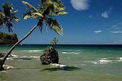
- Plaza Beach Resort: beach covered with white sands in its coast located at Sitio Bulihon, Barangay Tagcatong.
- Mount Carmel View Park: park commonly called by Carmenanons as "Marcos Park", located at San Isidro, Barangay Tagcatong. From here, one can view the entire Carmen and nearby municipalities, and the island province of Camiguin.
- Punta Diwata Cave: one of the popular destinations in Carmen consisting of 43 caves, located in Barangay Vinapor.
- Balite Beach Resort: located in Barangay Vinapor.
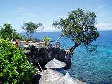
- Vinapor Blue Waters: located near the Cliffs of Barangay Vinapor, this resort features carved stones formed into a dinosaurs, a reason for it to be commonly called "Jurassic Park".
- Veranda I and II Resorts: a beach resort, hotel and convention venue located at Barangays Tagcatong and Rojales. It has air-conditioned rooms and suites, air conditioned cabañas and other facilities like cottages fronting beachfront, seafood and Chinese restaurants, mini-bar, convention hall and swimming pool.
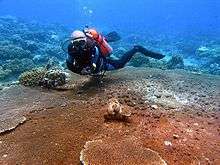
- Scuba diving sites: Carmen is known for its adventurous dive sites along the Punta Diwata Reefs and Balete Wall. It has six dive sites. Reef life includes soft and hard corals plus abundant reef and pelagic fishes. Profile ranges from sloping wall to cliffs with depths from 40 ft. to over a hundred, with generally sandy floors. Prime sites are located in barangays Vinapor, Tagcatong & Poblacion.
- Cabatuan Beach
- Kibanlag Falls
Transportation
In February 2017, the new integrated bus terminal was opened with buses for travel to and from Butuan and Cagayan de Oro.
TriSikad is also a option when traveling within the area of carmen.
And also from Carmen to Nasipit
Schools
Elementary
- Antonio Quiamjot Elementary School
- Cahayagan Elementary School
- Carmen Central Elementary School
- Cervantina Elementary School
- Doña Josefa Elementary School
- Elpidio Salas Elementary School
- Gosoon Elementary School
- Manoligao Elementary School
- Rojales Elementary School
- San Agustin Elementary School
- San Isidro Elementary School
- Tagcatong Central Elementary School
Secondary
- Carmen National High School
- Cahayagan National High School
- Manoligao National High School
- Our Lady of Carmen Academy of Caraga, Incorporated
- Vinapor National High School
References
- "Municipality". Quezon City, Philippines: Department of the Interior and Local Government. Retrieved 31 May 2013.
- "Province: Agusan del Norte". PSGC Interactive. Quezon City, Philippines: Philippine Statistics Authority. Retrieved 12 November 2016.
- "Carmen, Agusan del Norte Profile". PhilAtlas.com. Retrieved 15 June 2020.
- Census of Population (2015). "Caraga". Total Population by Province, City, Municipality and Barangay. PSA. Retrieved 20 June 2016.
- "PSA releases the 2015 Municipal and City Level Poverty Estimates". Quezon City, Philippines. Retrieved 12 October 2019.
- "Municipal: Carmen, Agusan del Norte". PSGC Interactive. Quezon City, Philippines: Philippine Statistics Authority. Retrieved 8 January 2016.
- Census of Population and Housing (2010). "Caraga". Total Population by Province, City, Municipality and Barangay. NSO. Retrieved 29 June 2016.
- "Carmen: Average Temperatures and Rainfall". Meteoblue. Retrieved 2 February 2020.
- "Republic Act No. 380 - Act Creating the Municipality of Carmen in the Province of Agusan". PhilippineLaw.info. 15 June 1949. Archived from the original on 31 May 2012. Retrieved 16 October 2016.
- Censuses of Population (1903–2007). "Caraga". Table 1. Population Enumerated in Various Censuses by Province/Highly Urbanized City: 1903 to 2007. NSO.
- "Province of Agusan del Norte". Municipality Population Data. Local Water Utilities Administration Research Division. Retrieved 17 December 2016.
External links
![]()
Places adjacent to Carmen, Agusan del Norte | ||||||||||
|---|---|---|---|---|---|---|---|---|---|---|
| ||||||||||
Cabadbaran (capital) | |
| Municipalities | |
| Component city | |
| Highly urbanized city |
|