Colorado State Highway 402
State Highway 402 (SH 402) is a 4.2 mi (6.8 km) long state highway in northern central Colorado. SH 402's western terminus is at a junction with U.S. Route 287 (US 287) in the city limits of Loveland, and the eastern terminus is at Interstate 25 (I-25) and US 87 east of Loveland.
| ||||
|---|---|---|---|---|
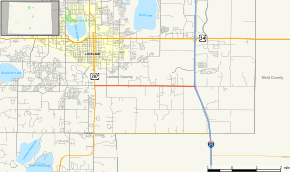 Map of Larimer County in northern Colorado with SH 402 highlighted in red | ||||
| Route information | ||||
| Maintained by CDOT | ||||
| Length | 4.2 mi[1] (6.8 km) | |||
| Major junctions | ||||
| West end | ||||
| East end | ||||
| Location | ||||
| Counties | Larimer | |||
| Highway system | ||||
Colorado State Highways
| ||||

Route description
The road begins at an intersection with U.S. Highway 287 in the southern part of Loveland. It begins as 14th Street through farmland along CR 18 and passes the community of Kings Corner.[2] After intersecting CR 9 and CR 7, the road meets its east end at an interchange with Interstate 25, concurrent with U.S. Highway 87, at exit 255.[1]
History
The route was numbered and established in 1950 by the Colorado Department of Transportation from U.S. Highway 287 to Interstate 25. Four years later, the road was entirely paved.[3] Since its establishment, the route has not been majorly adjusted.[2]
Major intersections
The entire route is in Larimer County.
| Location | mi | km | Destinations | Notes | |
|---|---|---|---|---|---|
| Loveland | 0.0 | 0.0 | Western terminus | ||
| | 4.2 | 6.8 | Eastern terminus; I-25 exit 255; interchange | ||
| 1.000 mi = 1.609 km; 1.000 km = 0.621 mi | |||||
References
- "Segment Descriptions for Highway 402". Colorado Department of Transportation. Retrieved 2008-04-12.
- Microsoft; Nokia (2010-06-11). "Overview Map of SH 402" (Map). Bing Maps. Microsoft. Retrieved 2010-06-11.
- Salek, Matthew E. "Colorado Routes 400-789". Retrieved 2010-06-11.