List of earthquakes in 2016

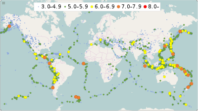
This is a list of earthquakes in 2016. Only earthquakes of magnitude 6 or above are included, unless they result in damage and/or casualties, or are notable for some other reason. All dates are listed according to UTC time. Maximum intensities are indicated on the Mercalli intensity scale and are sourced from United States Geological Survey (USGS) ShakeMap data. Major events took place in Ecuador, Italy, Taiwan, Indonesia and New Zealand this year, while the strongest tremor was observed in Papua New Guinea. 2016 was also the first year since 2008 with no magnitude 8+ earthquakes.

Earthquakes in 2016
Approximate epicenters of the earthquakes in 2016
Strongest magnitude7.9 Mw,  Papua New Guinea
Deadliest7.8 Mw, Ecuador
676 deaths
Total fatalities1,339
Number by magnitude
9.0+0
8.0−8.90
7.0−7.916
6.0−6.9127
5.0−5.91,507
4.0−4.912,771
 2015
2017 

Compared to other years

Number of earthquakes worldwide for 2006–2016[1]
Magnitude 2006 2007 2008 2009 2010 2011 2012 2013 2014 2015 2016
8.0–9.9 2 4 0 1 1 1 2 2 1 1 0
7.0–7.9 9 14 12 16 21 19 15 17 11 18 16
6.0–6.9 142 178 168 144 151 204 129 125 140 124 127
5.0–5.9 1,712 2,074 1,768 1,896 1,963 2,271 1,412 1,402 1,475 1,413 1,507
4.0–4.9 12,838 12,080 12,292 6,805 10,164 13,303 10,990 9,795 13,494 13,239 12,771
Total 14,703 14,350 14,240 8,862 12,300 15,798 12,548 11,341 15,121 14,795 14,421

An increase in detected earthquake numbers does not necessarily represent an increase in earthquakes per se. Population increase, habitation spread, and advances in earthquake detection technology all contribute to higher earthquake numbers being recorded over time.[2]

By death toll

Map of earthquakes in 2016. A total of 16,975 earthquakes are plotted.
Rank Death toll Magnitude Location MMI Depth (km) Date
1 676 7.8 Ecuador, Esmeraldas VIII (Severe) 20.6 April 16
2 299 6.2 Italy, Umbria IX (Violent) 4.4 August 24
3 117 6.4 Taiwan, Kaohsiung VII (Very strong) 23.0 February 6
4 104 6.5 Indonesia, Aceh IX (Violent) 13.0 December 6
5 41 7.0 Japan, Kyushu IX (Violent) 10.0 April 15
6 23 5.9 Tanzania, Kagera VII (Very strong) 40.0 September 10
7 11 6.7 India, Imphal VII (Very strong) 55.0 January 3

Listed are earthquakes with at least 10 dead.

By magnitude

Rank Magnitude Death toll Location MMI Depth (km) Date
1 7.9 0 Papua New Guinea, New Ireland VIII (Severe) 93.0 December 17
2 7.8 676 Ecuador, Esmeraldas VIII (Severe) 20.6 April 16
2 7.8 0 Indonesia, Sumatra III (Weak) 24.0 March 2
2 7.8 2 New Zealand, South Island IX (Violent) 22.0 November 14
2 7.8 1  Solomon Islands VIII (Severe) 41.0 December 8
6 7.7 0  Northern Mariana Islands VI (Strong) 212.4 July 29
7 7.6 0 Chile, Los Lagos VIII (Severe) 35.2 December 25
8 7.4 0  South Georgia and the South Sandwich Islands I (Not felt) 10.0 August 19
9 7.2 0  Russia, Kamchatka VI (Strong) 163.2 January 30
9 7.2 0  South Georgia and the South Sandwich Islands VI (Strong) 72.7 May 28
9 7.2 0  New Caledonia V (Moderate) 9.9 August 12
12 7.1 0 United States, Alaska VII (Very strong) 125.6 January 24
12 7.1 0  Ascension Island I (Not felt) 10.0 August 29
14 7.0 41 Japan, Kyushu IX (Violent) 10.0 April 15
14 7.0 0  Vanuatu VII (Very strong) 27.2 April 28
14 7.0 0 New Zealand, North Island VI (Strong) 19.0 September 1

Listed are earthquakes with at least 7.0 magnitude.

By month

January

January
Strongest magnitude7.2 Mw,  Russia
Deadliest6.7 Mw, India
11 deaths
Total fatalities13
Number by magnitude
8.0−8.90
7.0−7.92
6.0−6.911
5.0−5.9119
4.0−4.91,024
  • A magnitude 6.3 earthquake struck the Western Indian-Antarctic Ridge on January 1 at a depth of 10.0 km (6.2 mi). The shock had a maximum intensity of I (Not felt).[3]
  • A magnitude 6.7 earthquake struck India 30 km (19 mi) west of Imphal in the state of Manipur on January 3 at a depth of 55.0 km (34.2 mi). The shock had a maximum intensity of VII (Very strong).[4] At least 11 people were killed (six in India and five in Bangladesh), 200 others were injured and a large number of buildings were damaged.[5]
  • A magnitude 6.0 earthquake struck the Pacific-Antarctic Ridge on January 5 at a depth of 10.0 km (6.2 mi). The shock had a maximum intensity of I (Not felt).[6]
  • A magnitude 6.5 earthquake struck Indonesia 8 km (5.0 mi) east of the Talaud Islands, North Sulawesi on January 11 at a depth of 13.0 km (8.1 mi). The shock had a maximum intensity of VIII (Severe).[7]
  • A magnitude 6.2 earthquake struck Japan 74 km (46 mi) northwest of Rumoi on the island of Hokkaido on January 11 at a depth of 238.8 km (148.4 mi). The shock had a maximum intensity of IV (Light).[8]
  • A magnitude 6.1 earthquake struck Bolivia 12 km (7.5 mi) west northwest of Charagua, Cordillera Province on January 14 at a depth of 582.6 km (362.0 mi). The shock had a maximum intensity of II (Weak).[9]
  • A magnitude 6.7 earthquake struck offshore of Japan 52 km (32 mi) southeast of Shizunai on the island of Hokkaido on January 14 at a depth of 46.0 km (28.6 mi). The shock had a maximum intensity of VI (Strong).[10]
  • A magnitude 5.6 earthquake struck Indonesia 69 km (43 mi) south southeast of Namlea, Maluku on January 16 at a depth of 4.1 km (2.5 mi). The shock had a maximum intensity of VII (Very strong).[11] One person died, 19 were injured and about 120 houses were damaged in two villages on Ambelau island.[12]
  • A magnitude 5.9 earthquake struck China 70 km (43 mi) east southeast of Hongtu, Qinghai province on January 20 at a depth of 9.0 km (5.6 mi). The shock had a maximum intensity of VI (Strong).[13] Nine people were injured and 600 houses were damaged.[14]
  • A magnitude 6.6 earthquake struck offshore of Mexico 215 km (134 mi) southwest of Tomatlán, Jalisco state on January 21 at a depth of 10.0 km (6.2 mi). The shock had a maximum intensity of IV (Light).[15]
  • A magnitude 7.1 earthquake struck the United States 86 km (53 mi) east of Old Iliamna, Alaska on January 24 at a depth of 129.0 km (80.2 mi). The shock had a maximum intensity of VII (Very strong).[16] Four homes were destroyed in Kenai after a gas leak.[17]
  • A magnitude 4.4 earthquake struck Ethiopia 4 km (2.5 mi) north northeast of Awasa on January 24 at a depth of 10.0 km (6.2 mi).[18] About 100 students sustained minor injuries and there were power outages in Awasa.[19]
  • A magnitude 6.3 earthquake struck offshore of Morocco 50 km (31 mi) north northeast of Al Hoceima on January 25 at a depth of 12.0 km (7.5 mi). The shock had a maximum intensity of V (Moderate).[20] One person died,[21] fifteen were injured and some buildings were damaged; it also caused a blackout in the region.[22]
  • A magnitude 6.1 earthquake struck offshore of Papua New Guinea 94 km (58 mi) south southeast of Taron, New Ireland on January 26 at a depth of 26.0 km (16.2 mi). The shock had a maximum intensity of IV (Light).[23]
  • A magnitude 7.2 earthquake struck Russia 88 km (55 mi) north of Yelizovo on the Kamchatka Peninsula on January 30 at a depth of 177.0 km (110.0 mi). The shock had a maximum intensity of VI (Strong).[24]
  • A magnitude 6.1 earthquake struck offshore of Antarctica 473 km (294 mi) northeast of the Balleny Islands on January 31 at a depth of 10.0 km (6.2 mi). The shock had a maximum intensity of I (Not felt).[25]

February

February
Strongest magnitude6.4 Mw, Taiwan
6.4 Mw,  Papua New Guinea
Deadliest6.4 Mw, Taiwan
117 deaths
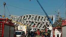
The collapsed 17-story Weiguan Jinlong residential building
Total fatalities118
Number by magnitude
8.0−8.90
7.0−7.90
6.0−6.910
5.0−5.993
4.0−4.9982
  • A magnitude 6.2 earthquake struck offshore of New Zealand 125 km (78 mi) northwest of L'Esperance Rock on February 1 at a depth of 391.0 km (243.0 mi). The shock had a maximum intensity of III (Weak).[26]
  • A magnitude 5.2 earthquake struck Nepal 19 km (12 mi) north of Kathmandu on February 5 at a depth of 23.5 km (14.6 mi). The shock had a maximum intensity of V (Moderate).[27] 66 people were injured in Nepal during this earthquake, while one person died of a heart attack in Muzaffarpur, India.[28]
  • A magnitude 6.4 earthquake struck Taiwan 25 km (16 mi) southeast of the Yujing district of Tainan City on February 6 at a depth of 23.0 km (14.3 mi). The shock had a maximum intensity of VII (Very strong).[29] Numerous buildings, including a residential tower, collapsed in Yongkang district.[30] 117 people were killed[31] and 550 were injured.[32]
  • A magnitude 6.4 earthquake struck offshore of Papua New Guinea 88 km (55 mi) west southwest of Panguna on February 8 at a depth of 29.0 km (18.0 mi). The shock had a maximum intensity of V (Moderate).[33]
  • A magnitude 6.3 earthquake struck Chile 36 km (22 mi) west of Ovalle on February 10 at a depth of 29.0 km (18.0 mi). The shock had a maximum intensity of VII (Very strong).[34]
  • A magnitude 6.3 earthquake struck Indonesia 0 km (0 mi) west of Komerda, East Nusa Tenggara on February 12 at a depth of 28.0 km (17.4 mi). The shock had a maximum intensity of VI (Strong).[35]
  • A magnitude 5.8 earthquake struck New Zealand 12 km (7.5 mi) east northeast of Christchurch on February 14 at a depth of 7.6 km (4.7 mi). The shock had a maximum intensity of VIII (Severe).[36] Minor damage was reported and parts of the region suffered from liquefaction. A part of Godley Head collapsed and other cliffs collapsed as well.[37]
  • A magnitude 6.0 earthquake struck offshore of Tonga 32 km (20 mi) west northwest of Nuku`alofa on February 15 at a depth of 10.0 km (6.2 mi). The shock had a maximum intensity of VI (Strong).[38]
  • A magnitude 6.1 earthquake struck the southern East Pacific Rise on February 16 at a depth of 13.0 km (8.1 mi). The shock had a maximum intensity of I (Not felt).[39]
  • A magnitude 6.0 earthquake struck Indonesia 151 km (94 mi) southeast of Tobelo on February 17 at a depth of 9.0 km (5.6 mi). The shock had a maximum intensity of VI (Strong).[40]
  • A magnitude 6.0 earthquake struck Chile 105 km (65 mi) west southwest of Coquimbo on February 22 at a depth of 12.0 km (7.5 mi). The shock had a maximum intensity of IV (Light).[41] This was an aftershock of the 6.3 quake.
  • A magnitude 6.1 earthquake struck the Western Pacific-Antarctic Ridge on February 27 at a depth of 10.0 km (6.2 mi). The shock had a maximum intensity of I (Not felt).[42]

March

March
Strongest magnitude7.8 Mw Indonesia
Number by magnitude
8.0−8.90
7.0−7.91
6.0−6.94
5.0−5.999
4.0−4.9990
  • A magnitude 7.8 earthquake struck offshore of Indonesia 659 km (409 mi) southwest of Muara Siberut, Mentawai Islands on March 2 at a depth of 24.0 km (14.9 mi). The shock had a maximum intensity of III (Weak).[43]
  • A magnitude 6.3 earthquake struck offshore of the United States 72 km (45 mi) south southeast of Atka, Alaska on March 12 at a depth of 19.0 km (11.8 mi). The shock had a maximum intensity of IV (Light).[44]
  • A magnitude 6.0 earthquake struck offshore of the United States 75 km (47 mi) south of Atka, Alaska on March 19 at a depth of 17.0 km (10.6 mi). The shock had a maximum intensity of IV (Light).[45] This was an aftershock of the 6.3 quake.
  • A magnitude 6.0 earthquake struck offshore of Antigua and Barbuda 124 km (77 mi) east northeast of Codrington on March 19 at a depth of 26.0 km (16.2 mi). The shock had a maximum intensity of IV (Light).[46]
  • A magnitude 6.4 earthquake struck offshore of Russia 216 km (134 mi) south of Ust'-Kamchatsk Staryy, Kamchatka Peninsula on March 20 at a depth of 30.0 km (18.6 mi). The shock had a maximum intensity of IV (Light).[47]

April

April
Strongest magnitude7.8 Mw Ecuador
Deadliest7.8 Mw Ecuador
676 deaths
Buildings collapsed in Porteviejo after the earthquake
Total fatalities734
Number by magnitude
8.0−8.90
7.0−7.93
6.0−6.919
5.0−5.9136
4.0−4.91,276
  • A magnitude 6.2 earthquake struck Papua New Guinea 119 km (74 mi) northeast of Angoram, East Sepik on April 1 at a depth of 6.0 km (3.7 mi). The shock had a maximum intensity of V (Moderate).[48]
  • A magnitude 6.9 earthquake struck Vanuatu 83 km (52 mi) north northwest of Port-Olry on April 3 at a depth of 26.0 km (16.2 mi). The shock had a maximum intensity of VI (Strong).[49]
  • A magnitude 6.7 earthquake struck Vanuatu 102 km (63 mi) west southwest of Sola on April 6 at a depth of 24.0 km (14.9 mi). The shock had a maximum intensity of V (Moderate).[50] This was an aftershock of the 6.9 quake.
  • A magnitude 6.1 earthquake struck offshore of Indonesia 71 km (44 mi) south southwest of Bunisari, West Java on April 6 at a depth of 29.0 km (18.0 mi). The shock had a maximum intensity of IV (Light).[51]
  • A magnitude 6.7 earthquake struck Vanuatu 103 km (64 mi) west of Sola on April 7 at a depth of 27.6 km (17.1 mi). The shock had a maximum intensity of V (Moderate).[52] This was an aftershock of the 6.9 quake.
  • A magnitude 4.1 earthquake struck Nepal 4 km (2.5 mi) south southwest of Patan on April 9 at a depth of 10.2 km (6.3 mi).[53] At least three people were injured.[54]
  • A magnitude 6.6 earthquake struck Afghanistan 42 km (26 mi) west southwest of Ashkasham, Badakhshan Province on April 10 at a depth of 212.0 km (131.7 mi). The shock had a maximum intensity of IV (Light).[55] Six people were killed and forty-six injured in Pakistan.[56]
  • A magnitude 6.9 earthquake struck Myanmar 75 km (47 mi) southeast of Mawlaik on April 13 at a depth of 136.0 km (84.5 mi). The shock had a maximum intensity of VI (Strong).[57] 2 people were killed and 70 injured in Assam, India.[58] 50 people were hurt in Chittagong, Bangladesh.[59]
  • A magnitude 6.0 earthquake struck the Philippines 15 km (9.3 mi) northwest of Siocon, Zamboanga del Norte on April 13 at a depth of 17.0 km (10.6 mi). The shock had a maximum intensity of VII (Very strong).[60]
  • A magnitude 6.2 earthquake struck Japan 3 km (1.9 mi) west of Kumamoto City on April 14 at a depth of 9.0 km (5.6 mi). The shock had a maximum intensity of VIII (Severe).[61] Nine people were killed, while more than 800 others were injured.[62][63] At least 20 homes and a wall of the Kumamoto Castle collapsed, while more than 24,000 people were forced to spend several nights in shelters.[64][65] This was a foreshock of the 7.0 quake.
  • A magnitude 6.0 earthquake struck Japan 5 km (3.1 mi) east northeast of Uto, Kumamoto Prefecture on April 14 at a depth of 8.0 km (5.0 mi). The shock had a maximum intensity of VIII (Severe).[66] This was a foreshock of the 7.0 quake.
  • A magnitude 6.4 earthquake struck Vanuatu 87 km (54 mi) northwest of Port-Olry on April 14 at a depth of 16.0 km (9.9 mi). The shock had a maximum intensity of VII (Very strong).[67] This was an aftershock of the 6.9 quake.
  • A magnitude 6.1 earthquake struck offshore of Guatemala 110 km (68 mi) south southwest of Champerico, Retalhuleu department on April 15 at a depth of 22.4 km (13.9 mi). The shock had a maximum intensity of IV (Light).[68]
  • A magnitude 7.0 earthquake struck Japan 1 km (0.62 mi) east of Kumamoto City on April 15 at a depth of 10.0 km (6.2 mi). The shock had a maximum intensity of IX (Violent).[69] 41 people were killed and more than 1,000 others were injured. 8,700 buildings were damaged and a bridge collapsed in Aso, Kumamoto Prefecture.[70][71]
  • A magnitude 7.8 earthquake struck Ecuador 27 km (17 mi) south southeast of Muisne in Esmeraldas province on April 16 at a depth of 20.6 km (12.8 mi). The shock had a maximum intensity of VIII (Severe).[72] 668 people were killed, 8 missing and over 6,200 injured. 7,000 buildings were destroyed or damaged.[73]
  • A magnitude 6.2 earthquake struck offshore of South Georgia and the South Sandwich Islands 108 km (67 mi) north of Visokoi Island on April 19 at a depth of 14.0 km (8.7 mi). The shock had a maximum intensity of IV (Light).[74]
  • A magnitude 6.2 earthquake struck Ecuador 20 km (12 mi) west northwest of Muisne in Esmeraldas province on April 20 at a depth of 14.0 km (8.7 mi). The shock had a maximum intensity of VI (Strong).[75] This was an aftershock of the 7.8 quake.
  • A magnitude 6.0 earthquake struck Ecuador 11 km (6.8 mi) north of Muisne in Esmeraldas province on April 20 at a depth of 10.0 km (6.2 mi). The shock had a maximum intensity of VII (Very strong).[76] This was an aftershock of the 7.8 quake.
  • A magnitude 6.0 earthquake struck Ecuador 35 km (22 mi) north northwest of Bahia de Caraquez in Manabi province on April 22 at a depth of 10.0 km (6.2 mi). The shock had a maximum intensity of VII (Very strong).[77] This was an aftershock of the 7.8 quake.
  • A magnitude 6.0 earthquake struck offshore of Mexico 83 km (52 mi) west southwest of Puerto Madero, Chiapas on April 25 at a depth of 16.0 km (9.9 mi). The shock had a maximum intensity of IV (Light).[78]
  • A magnitude 6.0 earthquake struck offshore of Mexico 75 km (47 mi) west southwest of Puerto Madero, Chiapas on April 27 at a depth of 16.0 km (9.9 mi). The shock had a maximum intensity of IV (Light).[79] This was an aftershock of the 6.0 quake.
  • A magnitude 7.0 earthquake struck Vanuatu 2 km (1.2 mi) north of Norsup on April 28 at a depth of 24.0 km (14.9 mi). The shock had a maximum intensity of VII (Very strong).[80]
  • A magnitude 6.6 earthquake struck 602 km (374 mi) east of the French Pacific minor territory of Clipperton Island on April 29 at a depth of 10.0 km (6.2 mi). The shock had a maximum intensity of I (Not felt).[81]

May

May
Strongest magnitude7.2 Mw  South Georgia and the South Sandwich Islands
Deadliest6.9 Mw  Ecuador
1 death
Total fatalities1
Number by magnitude
8.0−8.90
7.0−7.91
6.0−6.96
5.0−5.987
4.0−4.91,084
  • A magnitude 5.2 earthquake struck China 66 km (41 mi) northwest of Gyamotang, Tibet Autonomous Region on May 11 at a depth of 8.0 km (5.0 mi). The shock had a maximum intensity of V (Moderate).[82] Sixty people were reported injured, six seriously; with collapsed houses and bridges and roads damaged due to landslides.[83]
  • A magnitude 6.7 earthquake struck Ecuador 33 km (21 mi) southeast of Muisne in Esmeraldas province on May 18 at a depth of 16.0 km (9.9 mi). The shock had a maximum intensity of VII (Very strong).[84] Power cuts were reported near the epicenter.[85] This was an aftershock of the 7.8 quake in April.
  • A magnitude 6.9 earthquake struck Ecuador 24 km (15 mi) northwest of Rosa Zarate (also called Quinindé) in Esmeraldas province on May 18 at a depth of 29.9 km (18.6 mi). The shock had a maximum intensity of VII (Very strong).[86] One person was killed in Tosagua.[87] This was an aftershock of the 7.8 quake in April.
  • A magnitude 6.0 earthquake struck Australia 337 km (209 mi) east of Warburton in Western Australia on May 20 at a depth of 10.0 km (6.2 mi). The shock had a maximum intensity of VIII (Severe).[88]
  • A magnitude 6.4 earthquake struck Fiji 18 km (11 mi) south southeast of Ndoi Island on May 27 at a depth of 567.5 km (352.6 mi). The shock had a maximum intensity of II (Weak).[89] This was an foreshock of the 6.9 quake.
  • A magnitude 6.9 earthquake struck offshore of Fiji 155 km (96 mi) south southeast of Ndoi Island on May 28 at a depth of 405.7 km (252.1 mi). The shock had a maximum intensity of III (Weak).[90]
  • A magnitude 7.2 earthquake struck offshore of South Georgia and the South Sandwich Islands 53 km (33 mi) north northeast of Visokoi Island on May 28 at a depth of 78.0 km (48.5 mi). The shock had a maximum intensity of VI (Strong).[91]
  • A magnitude 5.4 earthquake struck Algeria 16 km (9.9 mi) south southwest of Lakhdaria, Bouïra Province on May 29 at a depth of 11.4 km (7.1 mi). The shock had a maximum intensity of V (Moderate).[92] Some houses and buildings collapsed in the region, and 28 people were injured, three of them seriously.[93]
  • A magnitude 6.4 earthquake struck offshore of Taiwan 94 km (58 mi) east northeast of Keelung on May 31 at a depth of 246.4 km (153.1 mi). The shock had a maximum intensity of IV (Light).[94]

June

June
Strongest magnitude6.6 Mw  Indonesia
Deadliest6.6 Mw  Indonesia
1 death
Total fatalities1
Number by magnitude
8.0−8.90
7.0−7.90
6.0−6.915
5.0−5.9111
4.0−4.91,149
  • A magnitude 6.6 earthquake struck Indonesia 79 km (49 mi) west of Sungai Penuh, Jambi on June 1 at a depth of 50.0 km (31.1 mi). The shock had a maximum intensity of VII (Very strong).[95] One person died of a heart attack during this earthquake, 18 were injured and more than 2,000 houses suffered damage.[96]
  • A magnitude 6.3 earthquake struck Indonesia 133 km (83 mi) southwest of Leksula, Maluku on June 5 at a depth of 429.6 km (266.9 mi). The shock had a maximum intensity of III (Weak).[97]
  • A magnitude 6.1 earthquake struck offshore of New Zealand 84 km (52 mi) south of Raoul Island on June 6 at a depth of 43.8 km (27.2 mi). The shock had a maximum intensity of IV (Light).[98]
  • A magnitude 6.3 earthquake struck offshore of Mexico 106 km (66 mi) south southwest of San Patricio, Jalisco state on June 7 at a depth of 10.0 km (6.2 mi). The shock had a maximum intensity of IV (Light).[99]
  • A magnitude 6.3 earthquake struck Indonesia 123 km (76 mi) west northwest of Kota Ternate, North Maluku on June 7 at a depth of 31.0 km (19.3 mi). The shock had a maximum intensity of VI (Strong).[100]
  • A magnitude 6.1 earthquake struck offshore of Indonesia 260 km (160 mi) south of Kute, West Nusa Tenggara on June 9 at a depth of 19.0 km (11.8 mi). The shock had a maximum intensity of III (Weak).[101]
  • A magnitude 6.1 earthquake struck Nicaragua 22 km (14 mi) east of Puerto Morazan, Chinandega on June 10 at a depth of 10.0 km (6.2 mi). The shock had a maximum intensity of VIII (Severe).[102] Some houses suffered damage in Chinandega, but no injuries were reported.[103]
  • A magnitude 6.2 earthquake struck the Solomon Islands 18 km (11 mi) west northwest of Auki on June 10 at a depth of 30.4 km (18.9 mi). The shock had a maximum intensity of VI (Strong).[104]
  • A magnitude 6.2 earthquake struck Vanuatu 98 km (61 mi) north northwest of Isangel on June 14 at a depth of 111.0 km (69.0 mi). The shock had a maximum intensity of IV (Light).[105]
  • A magnitude 6.3 earthquake struck offshore of Vanuatu 83 km (52 mi) south southwest of Isangel on June 19 at a depth of 13.0 km (8.1 mi). The shock had a maximum intensity of V (Moderate).[106]
  • A magnitude 6.0 earthquake struck offshore of Vanuatu 90 km (56 mi) southwest of Isangel on June 20 at a depth of 15.0 km (9.3 mi). The shock had a maximum intensity of IV (Light).[107] This was an aftershock of the 6.3 quake.
  • A magnitude 6.1 earthquake struck the Northern Mid-Atlantic Ridge on June 21 at a depth of 10.0 km (6.2 mi). The shock had a maximum intensity of I (Not felt).[108]
  • A magnitude 6.3 earthquake struck Papua New Guinea 67 km (42 mi) west northwest of Namatanai, New Ireland on June 21 at a depth of 354.0 km (220.0 mi). The shock had a maximum intensity of III (Weak).[109]
  • A magnitude 6.4 earthquake struck Kyrgyzstan 28 km (17 mi) south southeast of Sary-Tash on June 26 at a depth of 13.0 km (8.1 mi). The shock had a maximum intensity of VII (Very strong).[110]
  • A magnitude 6.0 earthquake struck Vanuatu 8 km (5.0 mi) northeast of Lakatoro on June 30 at a depth of 27.0 km (16.8 mi). The shock had a maximum intensity of V (Moderate).[111]

July

July
Strongest magnitude7.7 Mw  Northern Mariana Islands
Deadliest6.3 Mw  Ecuador
2 deaths
Total fatalities2
Number by magnitude
8.0−8.90
7.0−7.91
6.0−6.96
5.0−5.9119
4.0−4.91,044
  • A magnitude 6.0 earthquake struck offshore of Tonga 112 km (70 mi) north northeast of Hihifo on July 10 at a depth of 8.0 km (5.0 mi). The shock had a maximum intensity of IV (Light).[112]
  • A magnitude 6.3 earthquake struck Ecuador 33 km (21 mi) northwest of Rosa Zarate (also called Quinindé) in Esmeraldas province on July 11 at a depth of 21.0 km (13.0 mi). The shock had a maximum intensity of VI (Strong).[113] Two people died during this earthquake.[114]
  • A magnitude 6.3 earthquake struck offshore of New Zealand 199 km (124 mi) northeast of Raoul Island on July 13 at a depth of 12.0 km (7.5 mi). The shock had a maximum intensity of III (Weak).[115]
  • A magnitude 6.1 earthquake struck Vanuatu 72 km (45 mi) north northwest of Isangel on July 20 at a depth of 167.0 km (103.8 mi). The shock had a maximum intensity of IV (Light).[116]
  • A magnitude 6.1 earthquake struck Chile 54 km (34 mi) west northwest of the city of Diego de Almagro on July 25 at a depth of 72.0 km (44.7 mi). The shock had a maximum intensity of V (Moderate).[117]
  • A magnitude 6.4 earthquake struck Papua New Guinea 134 km (83 mi) southeast of Lorengau, Manus on July 25 at a depth of 14.0 km (8.7 mi). The shock had a maximum intensity of IV (Light).[118]
  • A magnitude 7.7 earthquake struck offshore of the United States trust territory of the Northern Mariana Islands 29 km (18 mi) southwest of Agrihan on July 29 at a depth of 196.0 km (121.8 mi). The shock had a maximum intensity of VI (Strong).[119]

August

August
Strongest magnitude7.4 Mw  South Georgia and the South Sandwich Islands
Deadliest6.2 Mw Italy
299 deaths
Rubble in the town center of Amatrice
Total fatalities309
Number by magnitude
8.0−8.90
7.0−7.93
6.0−6.910
5.0−5.9140
4.0−4.91,236
  • A magnitude 5.0 earthquake struck Azerbaijan 12 km (7.5 mi) northwest of Imishli on August 1 at a depth of 16.0 km (9.9 mi). The shock had a maximum intensity of V (Moderate).[120] One man died of a heart attack in Parsabad, in the far northwest of Iran.[121]
  • A magnitude 6.2 earthquake struck Argentina 49 km (30 mi) west southwest of La Quiaca, Jujuy on August 4 at a depth of 270.0 km (167.8 mi). The shock had a maximum intensity of IV (Light).[122]
  • A magnitude 6.3 earthquake struck offshore of Japan 71 km (44 mi) east northeast of Iwo Jima on August 4 at a depth of 510.0 km (316.9 mi). The shock had a maximum intensity of II (Weak).[123]
  • A magnitude 7.2 earthquake struck offshore of the French Pacific special collectivity of New Caledonia 110 km (68 mi) east of Île Hunter on August 12 at a depth of 16.4 km (10.2 mi). The shock had a maximum intensity of V (Moderate).[124]
  • A magnitude 6.1 earthquake struck offshore of Tonga 225 km (140 mi) southeast of the Minerva Reefs on August 12 at a depth of 112.8 km (70.1 mi). The shock had a maximum intensity of I (Not felt).[125]
  • A magnitude 5.5 earthquake struck Peru 39 km (24 mi) north of Lluta, Arequipa Province on August 15 at a depth of 20.0 km (12.4 mi). The shock had a maximum intensity of VI (Strong).[126] The quake caused five deaths, including an American tourist, and injured at least 40 people.[127]
  • A magnitude 5.7 earthquake struck Australia 54 km (34 mi) east northeast of Bowen in Queensland on August 18 at a depth of 7.8 km (4.8 mi). The shock had a maximum intensity of VI (Strong).[128] The quake, the highest magnitude to affect Queensland in 20 years, caused minor damage and briefly caused the evacuation of some airports.[129]
  • A magnitude 6.0 earthquake struck the southern East Pacific Rise on August 18 at a depth of 10 km (6.2 mi). The shock had a maximum intensity of I (Not felt).[130]
  • A magnitude 7.4 earthquake struck offshore of South Georgia and the South Sandwich Islands 240 km (150 mi) east southeast of South Georgia on August 19 at a depth of 10.0 km (6.2 mi). The shock had a maximum intensity of I (Not felt).[131]
  • A magnitude 6.0 earthquake struck offshore of Japan 169 km (105 mi) east northeast of Miyako, Iwate Prefecture on August 20 at a depth of 10.0 km (6.2 mi). The shock had a maximum intensity of IV (Light).[132]
  • A magnitude 6.1 earthquake struck offshore of South Georgia and the South Sandwich Islands 240 km (150 mi) east southeast of South Georgia on August 21 at a depth of 12.0 km (7.5 mi). The shock had a maximum intensity of I (Not felt).[133] This was an aftershock of the 7.4 quake.
  • A magnitude 6.0 earthquake struck Indonesia 132 km (82 mi) north of Nebe, East Nusa Tenggara on August 23 at a depth of 533.0 km (331.2 mi). The shock had a maximum intensity of II (Weak).[134]
  • A magnitude 6.2 earthquake struck Italy 10 km (6.2 mi) southeast of Norcia on August 24 at a depth of 4.4 km (2.7 mi). The shock had a maximum intensity of IX (Violent).[135] 299 people of various nations were killed, 388 were injured, with heavy damage all around the epicenter, especially in Amatrice.[136][137]
  • A magnitude 6.8 earthquake struck Myanmar 26 km (16 mi) west of Chauk on August 24 at a depth of 82.0 km (51.0 mi). The shock had a maximum intensity of VI (Strong).[138] Four people died, 20 were injured, and various stupas in Bagan were damaged.[139]
  • A magnitude 7.1 earthquake struck offshore of Ascension Island 980 km (610 mi) north northwest of the island on August 29 at a depth of 10.0 km (6.2 mi). The shock had a maximum intensity of I (Not felt).[140]
  • A magnitude 6.8 earthquake struck Papua New Guinea 39 km (24 mi) east of Namatanai, New Ireland on August 31 at a depth of 476.0 km (295.8 mi). The shock had a maximum intensity of III (Weak).[141]

September

September
Strongest magnitude7.0 Mw New Zealand
Deadliest5.9 Mw Tanzania
23 deaths
Total fatalities32
Number by magnitude
8.0−8.90
7.0−7.91
6.0−6.912
5.0−5.9164
4.0−4.91,268
  • A magnitude 7.0 earthquake struck offshore of New Zealand 175 km (109 mi) northeast of Gisborne on September 1 at a depth of 19.0 km (11.8 mi). The shock had a maximum intensity of VI (Strong).[142] A tsunami warning was issued after this earthquake, and waves of 30.0 cm (11.8 in) were reported near Gisborne.[143]
  • A magnitude 6.1 earthquake struck offshore of New Zealand 185 km (115 mi) northeast of Opotiki on September 1 at a depth of 13.7 km (8.5 mi). The shock had a maximum intensity of IV (Light).[144] This was an aftershock of the 7.0 quake.
  • A magnitude 5.8 earthquake struck the United States 14 km (8.7 mi) northwest of Pawnee, Oklahoma on September 3 at a depth of 5.6 km (3.5 mi). The shock had a maximum intensity of VII (Very strong).[145] It is the strongest earthquake ever recorded within the state.[146] One person was injured,[147] and the earthquake caused moderate damage, especially in Pawnee where buildings were damaged.[148]
  • A magnitude 4.7 earthquake struck Ecuador 22 km (14 mi) east northeast of Quito on September 5 at a depth of 10.0 km (6.2 mi). The shock had a maximum intensity of V (Moderate).[149] Six people were injured in nearby Quito during this earthquake, and some damage was caused.[150]
  • A magnitude 4.7 earthquake struck Pakistan 8 km (5.0 mi) east northeast of Batgram on September 5 at a depth of 25.9 km (16.1 mi). The shock had a maximum intensity of III (Weak).[151] Fifty-seven people were injured in a panicked evacuation of a school. Of those 57, three are reported to be in critical condition.[152]
  • A magnitude 6.1 earthquake struck offshore of Russia 185 km (115 mi) east southeast of Nikolskoye, Kamchatka Krai on September 5 at a depth of 8.0 km (5.0 mi). The shock had a maximum intensity of V (Moderate).[153]
  • A magnitude 6.1 earthquake struck Australia 21 km (13 mi) southwest of Macquarie Island on September 8 at a depth of 10.0 km (6.2 mi). The shock had a maximum intensity of VII (Very strong).[154]
  • A magnitude 6.1 earthquake struck Peru 52 km (32 mi) north of Moyobamba, Moyobamba Province on September 10 at a depth of 121.0 km (75.2 mi). The shock had a maximum intensity of IV (Light).[155]
  • A magnitude 5.9 earthquake struck Tanzania 27 km (17 mi) northeast of Nsunga, Kagera Region on September 10 at a depth of 40.0 km (24.9 mi). The shock had a maximum intensity of VII (Very strong).[156] Nineteen people were killed and 252 injured in Tanzania [157] as well as four people killed and seven injured in Uganda's Rakai District.[158] Several houses collapsed in the Kangera regional capital of Bukoba and in Uganda.[159]
  • A magnitude 5.1 earthquake struck Macedonia 4 km (2.5 mi) east northeast of Skopje on September 11 at a depth of 12.9 km (8.0 mi). The shock had a maximum intensity of VII (Very strong).[160] The quake caused minor damage to buildings and 30 people were injured while leaving their homes in a panic.[161]
  • A magnitude 5.4 earthquake struck South Korea 6 km (3.7 mi) south of Gyeongju, North Gyeongsang Province on September 12 at a depth of 13.0 km (8.1 mi). The shock had a maximum intensity of VII (Very strong).[162] It is the strongest earthquake ever recorded in South Korea. Eight people were injured and 253 properties damaged.[163]
  • A magnitude 6.0 earthquake struck Colombia 32 km (20 mi) east northeast of Mutatá, Antioquia on September 14 at a depth of 18.0 km (11.2 mi). The shock had a maximum intensity of VI (Strong).[164]
  • A magnitude 6.0 earthquake struck the Solomon Islands 86 km (53 mi) west of Honiara on September 14 at a depth of 14.0 km (8.7 mi). The shock had a maximum intensity of V (Moderate).[165]
  • A magnitude 6.0 earthquake struck offshore of Indonesia 51 km (32 mi) north northwest of Jayapura, Papua on September 17 at a depth of 9.0 km (5.6 mi). The shock had a maximum intensity of IV (Light).[166]
  • A magnitude 6.1 earthquake struck offshore of Japan 360 km (220 mi) southeast of Hachijō-jima, Izu Islands on September 20 at a depth of 9.0 km (5.6 mi). The shock had a maximum intensity of III (Weak).[167]
  • A magnitude 4.6 earthquake struck Pakistan 11 km (6.8 mi) north of Sann on September 22 at a depth of 10.0 km (6.2 mi).[168] The shock killed one person and left nine others injured in Hyderabad.[169]
  • A magnitude 6.2 earthquake struck offshore of Japan 143 km (89 mi) east southeast of Katsuura, Chiba Prefecture on September 23 at a depth of 10.0 km (6.2 mi). The shock had a maximum intensity of IV (Light).[170]
  • A magnitude 4.8 earthquake struck Burundi 24 km (15 mi) southeast of Cyangugu, Rwanda, on September 23 at a depth of 10.0 km (6.2 mi). The shock had a maximum intensity of VI (Strong).[171] The quake killed 6 people and injured 5 others in the neighbouring Democratic Republic of the Congo.[172] In Rwanda, this earthquake also killed one person, and injured more than 20 when various houses collapsed in Rusizi district.[173]
  • A magnitude 5.6 earthquake struck Romania 8 km (5.0 mi) west northwest of Nereju on September 23 at a depth of 92.0 km (57.2 mi). The shock had a maximum intensity of V (Moderate).[174] Two people were injured.[175]
  • A magnitude 6.3 earthquake struck the Philippines 36 km (22 mi) southeast of Tamisan, Davao Oriental, on September 24 at a depth of 65.0 km (40.4 mi). The shock had a maximum intensity of V (Moderate).[176]
  • A magnitude 6.4 earthquake struck offshore of Tonga 118 km (73 mi) west northwest of Neiafu on September 24 at a depth of 202.0 km (125.5 mi). The shock had a maximum intensity of IV (Light).[177]
  • A magnitude 6.9 earthquake struck Fiji 107 km (66 mi) north northeast of Ndoi Island on September 24 at a depth of 596.4 km (370.6 mi). The shock had a maximum intensity of III (Weak).[178]
  • A magnitude 5.5 earthquake struck Nicaragua 20 km (12 mi) north northeast of Nagarote, León department on September 28 at a depth of 7.1 km (4.4 mi). The shock had a maximum intensity of VI (Strong).[179] One person died of a heart attack during this earthquake, five others were injured and some houses collapsed in La Paz Centro.[180]

October

October
Strongest magnitude6.8 Mw  Papua New Guinea
Deadliest5.4 Mw  Pakistan
2 deaths
6.6 Mw Italy
2 deaths
Total fatalities7
Number by magnitude
8.0−8.90
7.0−7.90
6.0−6.98
5.0−5.998
4.0−4.9944
  • A magnitude 5.4 earthquake struck Pakistan 42 km (26 mi) north northwest of Athmuqam on October 1 at a depth of 10.0 km (6.2 mi). The shock had a maximum intensity of V (Moderate).[181] Two people died and thirty others were injured.[182]
  • A magnitude 6.3 earthquake struck Papua New Guinea 143 km (89 mi) north of Kimbe, West New Britain on October 15 at a depth of 442.0 km (274.6 mi). The shock had a maximum intensity of III (Weak).[183]
  • A magnitude 5.5 earthquake struck Greece 12 km (7.5 mi) north northwest of Rodotopion, Epirus on October 15 at a depth of 22.0 km (13.7 mi). The shock had a maximum intensity of IV (Light).[184] The quake damaged some buildings in villages near Ioannina.[185]
  • A magnitude 5.0 earthquake struck Peru 28 km (17 mi) southwest of Pimentel, Lambayeque Region on October 16 at a depth of 40.7 km (25.3 mi). The shock had a maximum intensity of V (Moderate).[186] One person died in Lambayeque when a floor lamp fell on her.[187]
  • A magnitude 6.8 earthquake struck Papua New Guinea 77 km (48 mi) west northwest of Kandrian, West New Britain on October 17 at a depth of 42.0 km (26.1 mi). The shock had a maximum intensity of VII (Very strong).[188]
  • A magnitude 5.9 earthquake struck China 135 km (84 mi) northeast of Dartang, Tibet Autonomous Region on October 17 at a depth of 23.3 km (14.5 mi). The shock had a maximum intensity of V (Moderate).[189] One person died during this earthquake.[190]
  • A magnitude 6.6 earthquake struck Indonesia 161 km (100 mi) north northwest of Pamanukan, West Java on October 19 at a depth of 614.0 km (381.5 mi). The shock had a maximum intensity of III (Weak).[191]
  • A magnitude 6.2 earthquake struck Japan 6 km (3.7 mi) south of Kurayoshi, Tottori Prefecture on October 21 at a depth of 5.6 km (3.5 mi). The shock had a maximum intensity of VIII (Severe).[192] At least 20 people were injured and some damage was caused.[193]
  • A magnitude 6.1 earthquake struck offshore of Tonga 132 km (82 mi) west northwest of Hihifo on October 26 at a depth of 10.0 km (6.2 mi). The shock had a maximum intensity of IV (Light).[194]
  • A magnitude 5.5 earthquake struck Italy 8 km (5.0 mi) east southeast of Sellano on October 26 at a depth of 10.0 km (6.2 mi). The shock had a maximum intensity of VI (Strong).[195] Several buildings collapsed. Two people were injured.[196] This was a foreshock of the 6.6 quake.
  • A magnitude 6.1 earthquake struck Italy 3 km (1.9 mi) north northwest of Visso on October 26 at a depth of 10.0 km (6.2 mi). The shock had a maximum intensity of IX (Violent).[197] One person died of a heart attack during this earthquake[198] and 8 others were injured when various houses collapsed in the region of Marche.[199] This was a foreshock of the 6.6 quake.
  • A magnitude 6.0 earthquake struck offshore of Chile 86 km (53 mi) west southwest of San Antonio on October 27 at a depth of 12.6 km (7.8 mi). The shock had a maximum intensity of IV (Light).[200]
  • A magnitude 6.6 earthquake struck Italy 7 km (4.3 mi) north of Norcia on October 30 at a depth of 8.0 km (5.0 mi). The shock had a maximum intensity of IX (Violent).[201] The villages of Arquata del Tronto,[202] Visso, Castelsantangelo sul Nera, Ussita, as well as the Basilica of Saint Benedict in Norcia, were destroyed.[203] Two people died of heart attacks during this earthquake[204] and 20 others were injured.[205]
  • A magnitude 5.6 earthquake struck Colombia 35 km (22 mi) east of the town of Colombia on October 31 at a depth of 33.0 km (20.5 mi). The shock had a maximum intensity of IV (Light).[206] The widespread damage caused by the earthquake led to a declaration of public disaster by the Colombian government in northern Huila.[207][208]

November

November
Strongest magnitude7.8 Mw New Zealand
Deadliest4.4 Mw  Poland
8 deaths
Total fatalities13
Number by magnitude
8.0−8.90
7.0−7.91
6.0−6.912
5.0−5.9159
4.0−4.91,267
  • A magnitude 6.0 earthquake struck Papua New Guinea 99 km (62 mi) west of Kandrian, West New Britain on November 1 at a depth of 52.0 km (32.3 mi). The shock had a maximum intensity of V (Moderate).[209]
  • A magnitude 6.3 earthquake struck Chile 21 km (13 mi) southeast of Curicó on November 4 at a depth of 90.0 km (55.9 mi). The shock had a maximum intensity of V (Moderate).[210]
  • A magnitude 5.0 earthquake struck the United States 2 km (1.2 mi) west of Cushing, Oklahoma on November 7 at a depth of 5.0 km (3.1 mi). The shock had a maximum intensity of VII (Very strong).[211] Multiple buildings were damaged and minor injuries were reported.[212]
  • A magnitude 6.0 earthquake struck offshore of Chile 42 km (26 mi) west northwest of Talcahuano on November 8 at a depth of 20.0 km (12.4 mi). The shock had a maximum intensity of V (Moderate).[213]
  • A magnitude 6.1 earthquake struck Japan 24 km (15 mi) east northeast of Ishinomaki, Miyagi Prefecture on November 11 at a depth of 42.4 km (26.3 mi). The shock had a maximum intensity of V (Moderate).[214]
  • A magnitude 7.8 earthquake struck New Zealand 55 km (34 mi) north northeast of Amberley on November 13 at a depth of 22.0 km (13.7 mi). The shock had a maximum intensity of IX (Violent).[215] Ruptures occurred on multiple fault lines in a complex sequence that lasted for about two minutes[216] with the largest amount of energy released far to the north of the epicentre.[217] Two people were killed, and widespread damage was reported across parts of the South Island.[218] A tsunami was also observed, reaching 2.5 m (8 ft 2 in) at Kaikoura.[219]
  • A magnitude 6.5 earthquake struck New Zealand 19 km (12 mi) north northwest of Kaikoura on November 13 at a depth of 24.0 km (14.9 mi). The shock had a maximum intensity of VI (Strong).[220] This was an aftershock of the 7.8 quake.
  • A magnitude 6.1 earthquake struck New Zealand 26 km (16 mi) north of Kaikoura on November 13 at a depth of 14.0 km (8.7 mi). The shock had a maximum intensity of VI (Strong).[221] This was an aftershock of the 7.8 quake.
  • A magnitude 6.2 earthquake struck New Zealand 12 km (7.5 mi) north of Kaikoura on November 13 at a depth of 6.3 km (3.9 mi). The shock had a maximum intensity of VII (Very strong).[222] This was an aftershock of the 7.8 quake.
  • A magnitude 6.5 earthquake struck New Zealand 41 km (25 mi) west southwest of Kaikoura on November 14 at a depth of 9.0 km (5.6 mi). The shock had a maximum intensity of VII (Very strong).[223] This was an aftershock of the 7.8 quake.
  • A magnitude 6.5 earthquake struck Argentina 8 km (5.0 mi) northwest of Pocito on November 20 at a depth of 108.0 km (67.1 mi). The shock had a maximum intensity of VI (Strong).[224] The quake, the strongest to affect the region in recent years, damaged various houses in San Juan province.[225]
  • A magnitude 6.9 earthquake struck offshore of Japan 33 km (21 mi) east southeast of Namie, Fukushima Prefecture on November 22 at a depth of 11.7 km (7.3 mi). The shock had a maximum intensity of VII (Very strong).[226] 14 people were injured and more than 1,900 homes briefly lost electricity.[227] A 60 cm (24 in) tsunami wave was reported in the port of Onahama of Iwaki, Fukushima; a 90 cm (35 in) wave hit Soma, Fukushima; and another wave 1 m (3 ft 3 in) in height struck the Fukushima Daiichi Nuclear Power Plant site after the 6.9 shock.[228] Chief Cabinet Secretary Yoshihide Suga said that the spent fuel cooling system of the third reactor at the neighboring Fukushima Daini Nuclear Power Plant had stopped as a result of the earthquake; TEPCO later reported the restart of the spent fuel cooling system after only 100 minutes of stoppage.[228][229][230][231]
  • A magnitude 6.9 earthquake struck offshore of El Salvador 149 km (93 mi) south southwest of Puerto El Triunfo on November 24 at a depth of 10.3 km (6.4 mi). The shock had a maximum intensity of V (Moderate).[232] One person died of a heart attack due to shock and fear after hearing a tsunami warning alert.[233]
  • A magnitude 6.6 earthquake struck the Xinjiang Autonomous Region of China 47 km (29 mi) east northeast of Karakul, Tajikistan on November 25 at a depth of 17.0 km (10.6 mi). The shock had a maximum intensity of VII (Very strong).[234] One person died when various houses near the epicenter collapsed, and livestock were killed.[235][236]
  • A magnitude 5.4 earthquake struck Nepal 19 km (12 mi) west northwest of Namche Bazar on November 27 at a depth of 10.0 km (6.2 mi). The shock had a maximum intensity of V (Moderate).[237] This quake triggered an avalanche that killed one person and left another injured.[238]
  • A magnitude 4.4 earthquake struck Poland 1 km (0.62 mi) east southeast of Głogów on November 29 at a depth of 10.0 km (6.2 mi). The shock had a maximum intensity of IV (Light).[239] This earthquake caused a mine collapse in Rudna, near the epicenter. Eight miners were killed and five others injured.[240]

December

December
Strongest magnitude7.9 Mw  Papua New Guinea
Deadliest6.5 Mw Indonesia
104 deaths
Total fatalities109
Number by magnitude
8.0−8.90
7.0−7.93
6.0−6.915
5.0−5.9200
4.0−4.9754
  • A magnitude 5.2 earthquake struck Costa Rica 9 km (5.6 mi) northeast of Cartago on December 1 at a depth of 5.0 km (3.1 mi). The shock had a maximum intensity of VI (Strong).[241] The earthquake caused landslides and damaged some homes, forcing at least 5 families to move to a community centre.[242]
  • A magnitude 6.2 earthquake struck Peru 44 km (27 mi) northeast of Huarichancara, Puno Region on December 1 at a depth of 12.0 km (7.5 mi). The shock had a maximum intensity of VII (Very strong).[243] At least 40 houses in Lampa Province were damaged, with some suffering total collapse. One person died and 17 others were injured.[244]
  • A magnitude 6.3 earthquake struck Indonesia 147 km (91 mi) north northeast of Palu'e Island, East Nusa Tenggara on December 5 at a depth of 526.0 km (326.8 mi). The shock had a maximum intensity of II (Weak).[245]
  • A magnitude 6.5 earthquake struck Indonesia 14 km (8.7 mi) west northwest of Meureudu, Aceh on December 6 at a depth of 13.0 km (8.1 mi). The shock had a maximum intensity of IX (Violent).[246] About 245 buildings collapsed as a result of the quake. 104 people were killed and over 900 were injured,[247] of which 136 suffered serious injuries.[248]
  • A magnitude 6.0 earthquake struck China 58 km (36 mi) south southeast of Shihezi in the Xinjiang Autonomous Region on December 8 at a depth of 17.6 km (10.9 mi). The shock had a maximum intensity of VI (Strong).[249] Two people were injured, and 25 houses suffered damage in Ürümqi region.[250]
  • A magnitude 6.6 earthquake struck offshore of the United States 164 km (102 mi) west of Ferndale, California on December 8 at a depth of 8.5 km (5.3 mi). The shock had a maximum intensity of IV (Light).[251]
  • A magnitude 7.8 earthquake struck the Solomon Islands 69 km (43 mi) west southwest of Kirakira on December 8 at a depth of 40.0 km (24.9 mi). The shock had a maximum intensity of VIII (Severe).[252] Tsunami waves up to 5.0 cm (2.0 in) were measured in New Caledonia and Vanuatu.[253] More than 200 buildings in the southern part of Malaita were damaged and buildings collapsed in Makira; more than 7,000 people were affected by the quake. An eleven-year-old girl died when a building collapsed.[254][255][256]
  • A magnitude 6.5 earthquake struck the Solomon Islands 79 km (49 mi) west southwest of Kirakira on December 8 at a depth of 12.3 km (7.6 mi). The shock had a maximum intensity of VI (Strong).[257] This was an aftershock of the 7.8 quake.
  • A magnitude 4.4 earthquake struck Croatia 2 km (1.2 mi) south southeast of Trogir, Split-Dalmatia county on December 9 at a depth of 22.5 km (14.0 mi). The shock had a maximum intensity of VI (Strong).[258] The quake caused minor damage in the form of cracked walls and broken windows.[259]
  • A magnitude 6.9 earthquake struck offshore of the Solomon Islands 92 km (57 mi) west southwest of Kirakira on December 9 at a depth of 19.7 km (12.2 mi). The shock had a maximum intensity of VII (Very strong).[260] This was an aftershock of the 7.8 quake.
  • A magnitude 6.0 earthquake struck Papua New Guinea 132 km (82 mi) west northwest of Arawa, Bougainville on December 10 at a depth of 142.6 km (88.6 mi). The shock had a maximum intensity of IV (Light).[261]
  • A magnitude 6.0 earthquake struck offshore of the United States trust territory of the Northern Mariana Islands 97 km (60 mi) north northwest of Farallon de Pajaros on December 14 at a depth of 22.4 km (13.9 mi). The shock had a maximum intensity of IV (Light).[262]
  • A magnitude 7.9 earthquake struck Papua New Guinea 54 km (34 mi) east of Taron, New Ireland on December 17 at a depth of 94.5 km (58.7 mi). The shock had a maximum intensity of VIII (Severe).[263] Although tsunami waves up to 8.0 cm (3.1 in) were measured[264] and power was knocked out in some parts of the country, no reports of injuries or damage were reported.[265]
  • A magnitude 6.3 earthquake struck offshore of Papua New Guinea 168 km (104 mi) southeast of Taron, New Ireland on December 17 at a depth of 8.4 km (5.2 mi). The shock had a maximum intensity of IV (Light).[266] This was an aftershock of the 7.9 quake.
  • A magnitude 6.2 earthquake struck the Federated States of Micronesia 22 km (14 mi) east southeast of Ngulu Atoll on December 18 at a depth of 19.0 km (11.8 mi). The shock had a maximum intensity of V (Moderate).[267]
  • A magnitude 6.4 earthquake struck Peru's Ucayali Region 201 km (125 mi) south of Tarauaca, Brazil on December 18 at a depth of 612.0 km (380.3 mi). The shock had a maximum intensity of II (Weak).[268]
  • A magnitude 5.4 earthquake struck Ecuador 6 km (3.7 mi) south southwest of Propicia, Esmeraldas Province on December 19 at a depth of 10.0 km (6.2 mi). The shock had a maximum intensity of VI (Strong).[269] This earthquake damaged houses, hotels, and caused some landslides in Atacames. Three people died and 47 others were injured.[270]
  • A magnitude 6.4 earthquake struck the Solomon Islands 81 km (50 mi) west northwest of Kirakira on December 20 at a depth of 20.0 km (12.4 mi). The shock had a maximum intensity of VI (Strong).[271] This was an aftershock of the 7.8 quake.
  • A magnitude 6.7 earthquake struck offshore of Indonesia 283 km (176 mi) east northeast of Dili, East Timor on December 21 at a depth of 152.0 km (94.4 mi). The shock had a maximum intensity of V (Moderate).[272]
  • A magnitude 7.6 earthquake struck Chile's Chiloé Island 41 km (25 mi) southwest of Quellón on December 25 at a depth of 38.0 km (23.6 mi). The shock had a maximum intensity of VIII (Severe).[273] The quake ripped up a road near Lake Tarahuin. 4,000 people were evacuated in the Los Lagos area after a tsunami warning, but this alert was lifted one hour later.[274][275]
  • A magnitude 5.9 earthquake struck Japan 13 km (8.1 mi) northeast of Daigo, Ibaraki Prefecture on December 28 at a depth of 7.0 km (4.3 mi). The shock had a maximum intensity of VII (Very strong).[276] Two people were injured during this earthquake.[277]
  • A magnitude 6.2 earthquake struck Indonesia 29 km (18 mi) south of Tolotangga, West Nusa Tenggara on December 29 at a depth of 79.0 km (49.1 mi). The shock had a maximum intensity of V (Moderate).[278]

See also

References

  1. "USGS Real-time Earthquake Map with exact dates and live earthquake reports". United States Geological Survey.
  2. "USGS Earthquake Myths". United States Geological Survey. Archived from the original on 2016-03-19.
  3. "M6.3 - Western Indian-Antarctic Ridge". United States Geological Survey. January 1, 2016. Retrieved January 1, 2016.
  4. "M6.7 - 30km W of Imphal, India". United States Geological Survey. January 3, 2015. Retrieved January 3, 2015.
  5. "Quake strikes northeast India, Bangladesh; 11 dead, nearly 200 hurt". Associated Press. Retrieved January 4, 2016.
  6. "M6.0 - Pacific-Antarctic Ridge". United States Geological Survey. January 5, 2016. Retrieved February 20, 2016.
  7. "M6.5 - 227km SE of Sarangani, Philippines". United States Geological Survey. January 11, 2016. Retrieved January 11, 2016.
  8. "M6.2 - 74km NW of Rumoi, Japan". United States Geological Survey. January 11, 2016. Retrieved January 11, 2016.
  9. "M6.1 - 12km WNW of Charagua, Bolivia". United States Geological Survey. January 14, 2016. Retrieved January 14, 2016.
  10. "M6.7 - 52km SE of Shizunai, Japan". United States Geological Survey. January 14, 2016. Retrieved January 15, 2016.
  11. "M5.6 - 69km SSE of Namlea, Indonesia". United States Geological Survey. January 16, 2016. Retrieved January 17, 2016.
  12. "5.4-magnitude earthquake hits south buru district causing damage: Agency". www.antaranews.com. Retrieved 2016-12-20.
  13. "M5.9 - 70km ESE of Hongtu, China". United States Geological Survey. January 20, 2016. Retrieved January 24, 2016.
  14. "Nine Injured in N.W. China Quake". Xinhua. January 21, 2016. Retrieved January 24, 2016.
  15. "M6.6 - 215km SW of Tomatlan, Mexico". United States Geological Survey. January 21, 2016. Retrieved January 24, 2016.
  16. "M7.1 - 86km E of Old Iliamna, Alaska". United States Geological Survey. January 24, 2016. Retrieved February 6, 2016.
  17. "Red Cross sends team to Kenai to assist families affected by 7.1 earthquake". January 24, 2016. Archived from the original on January 24, 2016. Retrieved January 24, 2016.
  18. "M 4.4 - 4km NNE of Awasa, Ethiopia". United States Geological Survey. January 24, 2016. Retrieved January 28, 2017.
  19. "Magnitude 4.3 Earthquake strikes Awassa". Ethiopia Observer. January 25, 2016. Archived from the original on 2017-02-02. Retrieved January 28, 2017.
  20. "M6.3 - 50km NNE of Al Hoceima, Morocco". United States Geological Survey. January 25, 2016. Retrieved January 25, 2016.
  21. "UPDATE: Child killed as powerful earthquake strikes southern Spain and Melilla". The Olive Press. January 25, 2016. Retrieved January 28, 2017.
  22. "Streets littered with rubble as 6.1 quake strikes off coasts of Spain, Morocco (VIDEO)". RT. January 25, 2016. Retrieved January 26, 2016.
  23. "M6.1 - 94km SSE of Taron, Papua New Guinea". United States Geological Survey. January 26, 2016. Retrieved March 6, 2016.
  24. "M7.2 - 88km N of Yelizovo, Russia". United States Geological Survey. January 30, 2016. Retrieved January 30, 2016.
  25. "M6.1 - Balleny Islands region". United States Geological Survey. January 31, 2016. Retrieved January 31, 2016.
  26. "M6.2 - 125km NW of L'Esperance Rock, New Zealand". United States Geological Survey. February 1, 2016. Retrieved February 1, 2016.
  27. "M 5.2 - 19km N of Kathmandu, Nepal". United States Geological Survey. February 5, 2016. Retrieved December 20, 2016.
  28. Disasters, Recent Natural (February 6, 2016). "Magnitude 5.5 strong tremor rattles Nepal; One killed in Bihar, India". www.disaster-report.com. Retrieved December 20, 2016.
  29. "M 6.4 - 25km SE of Yujing, Taiwan". United States Geological Survey. February 6, 2016. Retrieved February 14, 2016.
  30. "Multiple buildings collapse, casualties unknown in 6.4 quake in Taiwan". RT. February 6, 2016. Retrieved February 6, 2016.
  31. "Body of last victim of apartment collapse in Tainan found". Focus Taiwan. February 18, 2016. Retrieved February 18, 2016.
  32. Huang Kuo-fang; Elizabeth Hsu. "Remains of last unaccounted-for quake victim found". Focus Taiwan.
  33. "M6.4 - 88km WSW of Panguna, Papua New Guinea". United States Geological Survey. February 8, 2016. Retrieved February 8, 2016.
  34. "M6.3 - 36km W of Ovalle, Chile". United States Geological Survey. February 10, 2016. Retrieved February 10, 2016.
  35. "M6.3 - 0km W of Komerda, Indonesia". United States Geological Survey. February 12, 2016. Retrieved February 12, 2016.
  36. "M5.8 - 12km ENE of Christchurch, New Zealand". United States Geological Survey. February 14, 2016. Retrieved February 14, 2016.
  37. "Christchurch hit by severe earthquake". February 14, 2016. Retrieved February 14, 2016.
  38. "M6.0 - 32km WNW of Nuku'alofa, Tonga". United States Geological Survey. February 15, 2016. Retrieved March 10, 2016.
  39. "M6.1 - Southern East Pacific Rise". United States Geological Survey. February 16, 2016. Retrieved December 28, 2016.
  40. "M6.0 - 151km SE of Tobelo, Indonesia". United States Geological Survey. February 17, 2016. Retrieved February 17, 2016.
  41. "M6.0 - 105km WSW of Coquimbo, Chile". United States Geological Survey. February 22, 2016. Retrieved April 6, 2016.
  42. "M6.1 - Western Pacific-Antarctic Ridge". United States Geological Survey. February 27, 2016. Retrieved March 21, 2016.
  43. "M7.8 - Southwest of Sumatra, Indonesia". United States Geological Survey. March 2, 2016. Retrieved March 2, 2016.
  44. "M6.3 - 72km SSE of Atka, Alaska". United States Geological Survey. March 12, 2016. Retrieved March 12, 2016.
  45. "M6.0 - 75km S of Atka, Alaska". United States Geological Survey. March 19, 2016. Retrieved March 19, 2016.
  46. "M6.0 - 124km ENE of Codrington, Barbuda". United States Geological Survey. March 19, 2016. Retrieved March 19, 2016.
  47. "M6.4 - 216km S of Ust'-Kamchatsk Staryy, Russia". United States Geological Survey. March 20, 2016. Retrieved March 20, 2016.
  48. "M6.2 - 119km NE of Angoram, Papua New Guinea". United States Geological Survey. April 1, 2016. Retrieved April 6, 2016.
  49. "M6.9 - 83km NNW of Port-Olry, Vanuatu". United States Geological Survey. April 3, 2016. Retrieved April 3, 2016.
  50. "M6.7 - 102km WSW of Sola, Vanuatu". United States Geological Survey. April 6, 2016. Retrieved April 6, 2016.
  51. "M6.1 - 71km SSW of Bunisari, Indonesia". United States Geological Survey. April 6, 2016. Retrieved April 6, 2016.
  52. "M6.7 - 106km W of Sola, Vanuatu". United States Geological Survey. April 7, 2016. Retrieved April 7, 2016.
  53. "M4.1 - 4km SSW of Patan, Nepal". United States Geological Survey. April 10, 2016. Retrieved April 13, 2016.
  54. "Earthquake magnitude 4.5 struck Nepal". Xinhua News Agency. April 9, 2016. Retrieved April 9, 2016.
  55. "M6.6 - 42km WSW of Ashkasham, Afghanistan". United States Geological Survey. April 10, 2016. Retrieved April 10, 2016.
  56. "At Least 6 Killed, 46 Injured in Pakistan by Afghanistan Earthquake". LAHT. April 11, 2016. Retrieved April 11, 2016.
  57. "M6.9 - 75km SE of Mawlaik, Burma". United States Geological Survey. April 13, 2016. Retrieved April 13, 2016.
  58. "Assam: At least two killed, 70 injured in earthquake". dnaindia.com. DNA India. 2016-04-14. Retrieved April 14, 2016.
  59. "Earthquake: 50 hurt, 4 buildings tilt in Ctg". The Daily Star. April 13, 2016. Retrieved April 13, 2016.
  60. "M6.0 - 15km NW of Siocon, Philippines". United States Geological Survey. April 13, 2016. Retrieved August 24, 2016.
  61. "M6.2 - 3km W of Kumamoto-shi, Japan". United States Geological Survey. April 14, 2016. Retrieved April 14, 2016.
  62. "26 new fatalities as more quakes hit Kyushu; 900 or so injured". Asahi. April 16, 2016. Retrieved April 16, 2016.
  63. "Strong 7.3 quake hits Japan just a day after smaller tremor kills 10". Weather.com. April 14, 2016. Retrieved April 14, 2016.
  64. "6.2 Magnitude Earthquake Hits Southern Japan, Killing 2; Homes Collapse, 45 Injured". Associated Press. April 15, 2016. Retrieved April 16, 2016.
  65. "9 dead, over 1,000 injured in Kyushu quake ‹ Japan Today: Japan News and Discussion". Archived from the original on 2016-04-15.
  66. "M6.0 - 5km ENE of Uto, Japan". United States Geological Survey. April 14, 2016. Retrieved April 14, 2016.
  67. "M6.4 - 87km NW of Port-Olry, Vanuatu". United States Geological Survey. April 14, 2016. Retrieved April 15, 2016.
  68. "M6.1 - 110km SSW of Champerico, Guatemala". United States Geological Survey. April 15, 2016. Retrieved April 15, 2016.
  69. "M7.0 - 1km E of Kumamoto-shi, Japan". United States Geological Survey. April 15, 2016. Retrieved April 15, 2016.
  70. "70% of Kumamoto victims died in collapsed homes". Asahi. May 9, 2016. Retrieved May 1, 2016.
  71. "Last Kumamoto quake victim ID'd, leaving death toll at 50". The Japan Times. August 14, 2016. Retrieved October 17, 2016.
  72. "M7.8 - 27km SSE of Muisne, Ecuador". United States Geological Survey. April 16, 2016. Retrieved April 17, 2016.
  73. "Six months report Ecuador: Earthquake" (PDF).
  74. "M6.2 - 108km N of Visikoi Island, South Georgia and the South Sandwich Islands". United States Geological Survey. April 19, 2016. Retrieved August 24, 2016.
  75. "M6.2 - 20km WNW of Muisne, Ecuador". United States Geological Survey. April 20, 2016. Retrieved April 20, 2016.
  76. "M6.0 - 11km N of Muisne, Ecuador". United States Geological Survey. April 20, 2016. Retrieved April 20, 2016.
  77. "M6.0 - 35km NNW of Bahia de Caraquez, Ecuador". United States Geological Survey. April 22, 2016. Retrieved April 22, 2016.
  78. "M6.0 - 83km WSW of Puerto Madero, Mexico". United States Geological Survey. April 25, 2016. Retrieved June 8, 2016.
  79. "M6.0 - 75km WSW of Puerto Madero, Mexico". United States Geological Survey. April 27, 2016. Retrieved June 8, 2016.
  80. "M7.0 - 2km N of Norsup, Vanuatu". United States Geological Survey. April 28, 2016. Retrieved April 29, 2016.
  81. "M6.6 - Northern East Pacific Rise". United States Geological Survey. April 29, 2016. Retrieved April 29, 2016.
  82. "M5.2 - 66km NW of Gyamotang, China". United States Geological Survey. May 11, 2016. Retrieved May 12, 2016.
  83. "Shallow quake hits Tibet, causes landslide". SBS News. Australian Associated Press. May 11, 2016. Retrieved May 12, 2016.
  84. "M6.7 - 33km SE of Muisne, Ecuador". United States Geological Survey. May 18, 2016. Retrieved May 18, 2016.
  85. Gonzalo Solano; Joshua Goodman; Al Clendenning (May 18, 2016). "Magnitude-6.7 earthquake reported in Ecuador". Quito: CTV News. Associated Press. Retrieved May 18, 2016.
  86. "M6.9 - 24km NW of Rosa Zarate, Ecuador". United States Geological Survey. May 18, 2016. Retrieved May 18, 2016.
  87. Alexandra Valencia; Andrew Cawthorne (May 18, 2016). "Ecuador coast hit by two earthquakes; one dead". Quito: Reuters Canada. Retrieved May 18, 2016.
  88. "M6.0 - Northern Territory, Australia". United States Geological Survey. May 20, 2016. Retrieved May 28, 2016.
  89. "M6.4 - 18km SSE of Ndoi Island, Fiji". United States Geological Survey. May 27, 2016. Retrieved May 27, 2016.
  90. "M6.9 - 155km SSE of Ndoi Island, Fiji". United States Geological Survey. May 28, 2016. Retrieved May 28, 2016.
  91. "M7.2 - 53km NNE of Visokoi Island, South Georgia and the South Sandwich Islands". United States Geological Survey. May 28, 2016. Retrieved May 28, 2016.
  92. "M5.4 - 16km SSW of Lakhdaria, Algeria". United States Geological Survey. May 29, 2016. Retrieved August 18, 2016.
  93. "5.3 magnitude earthquake injures 28 people in Algeria's Medea". Africanews. May 30, 2016. Retrieved August 18, 2016.
  94. "M6.4 - 94km ENE of Keelung, Taiwan". United States Geological Survey. May 31, 2016. Retrieved May 31, 2016.
  95. "M6.6 - 79km W of Sungaipenuh, Indonesia". United States Geological Survey. June 2, 2016. Retrieved June 2, 2016.
  96. "2,663 houses damaged in June 2 quake". Jakarta: Antara News. June 5, 2016. Retrieved August 15, 2016.
  97. "M6.3 - 133km SW of Leksula, Indonesia". United States Geological Survey. June 5, 2016. Retrieved June 6, 2016.
  98. "M6.1 - 84km S of Raoul Island, New Zealand". United States Geological Survey. June 6, 2016. Retrieved June 6, 2016.
  99. "M6.3 - 106km SSW of San Patricio, Mexico". United States Geological Survey. June 8, 2016. Retrieved June 8, 2016.
  100. "M6.3 - 123km WNW of Kota Ternate, Indonesia". United States Geological Survey. June 8, 2016. Retrieved June 8, 2016.
  101. "M6.2 - 284km S of Kute, Indonesia". United States Geological Survey. June 9, 2016. Retrieved June 9, 2016.
  102. "M6.1 - 22km E of Puerto Morazan, Nicaragua". United States Geological Survey. June 10, 2016. Retrieved June 10, 2016.
  103. Grafica, La Prensa. "Sismo de 6.1 en Nicaragua deja al menos once casas dañadas". La Prensa Gráfica. Retrieved August 23, 2016.
  104. "M6.2 - 18km WNW of Auki, Solomon Islands". United States Geological Survey. June 10, 2016. Retrieved June 10, 2016.
  105. "M6.2 - 98km NNW of Isangel, Vanuatu". United States Geological Survey. June 14, 2016. Retrieved June 14, 2016.
  106. "M6.3 - 83km SSW of Isangel, Vanuatu". United States Geological Survey. June 19, 2016. Retrieved June 19, 2016.
  107. "M6.0 - 90km SW of Isangel, Vanuatu". United States Geological Survey. June 20, 2016. Retrieved June 22, 2016.
  108. "M6.1 - Northern Mid-Atlantic Ridge". United States Geological Survey. June 21, 2016. Retrieved June 22, 2016.
  109. "M6.3 - 67km WNW of Namatanai, Papua New Guinea". United States Geological Survey. June 21, 2016. Retrieved June 22, 2016.
  110. "M6.4 - 28km SSE of Sary-Tash, Kyrgyzstan". United States Geological Survey. June 26, 2016. Retrieved June 26, 2016.
  111. "M6.0 - 8km NE of Lakatoro, Vanuatu". United States Geological Survey. June 30, 2016. Retrieved August 24, 2016.
  112. "M6.0 - 112km NNE of Hihifo, Tonga". United States Geological Survey. July 10, 2016. Retrieved July 10, 2016.
  113. "M6.3 - 33km NW of Rosa Zarate, Ecuador". United States Geological Survey. July 11, 2016. Retrieved July 11, 2016.
  114. "Sismos y estado de excepción siguen; hubo dos muertos" (in Spanish). El universo. July 12, 2016. Retrieved July 12, 2016.
  115. "M6.3 - 199km NE of Raoul Island, New Zealand". United States Geological Survey. July 13, 2016. Retrieved July 13, 2016.
  116. "M6.1 - 72km NNW of Isangel, Vanuatu". United States Geological Survey. July 20, 2016. Retrieved July 21, 2016.
  117. "M6.1 - 54km WNW of Diego de Almagro, Chile". United States Geological Survey. July 25, 2016. Retrieved July 25, 2016.
  118. "M6.4 - 134km SE of Lorengau, Papua New Guinea". United States Geological Survey. July 25, 2016. Retrieved July 25, 2016.
  119. "M7.7 - 29km SW of Agrihan, Northern Mariana Islands". United States Geological Survey. July 29, 2016. Retrieved July 29, 2016.
  120. "M5.0 - 12km NW of Imishli, Azerbaijan". United States Geological Survey. August 1, 2016. Retrieved August 2, 2016.
  121. "Man in Iran dead as a result of quake in Azerbaijan". Trend News Agency. August 1, 2016. Retrieved August 2, 2016.
  122. "M6.2 - 49km WSW of La Quiaca, Argentina". United States Geological Survey. August 4, 2016. Retrieved August 5, 2016.
  123. "M6.3 - 71km ENE of Iwo Jima, Japan". United States Geological Survey. August 4, 2016. Retrieved August 6, 2016.
  124. "M7.2 - 110km E of Ile Hunter, New Caledonia". United States Geological Survey. August 12, 2016. Retrieved August 12, 2016.
  125. "M6.1 - South of the Fiji Islands". United States Geological Survey. August 12, 2016. Retrieved October 16, 2016.
  126. "M5.5 - 39km N of Lluta, Peru". United States Geological Survey. August 15, 2016. Retrieved August 19, 2016.
  127. "Sismo en Arequipa: aumentan a 5 los fallecidos en Caylloma" (in Spanish). DiarioCorreo.pe. August 17, 2016. Retrieved August 18, 2016.
  128. "M5.7 - 54km ENE of Bowen, Australia". United States Geological Survey. August 18, 2016. Retrieved August 19, 2016.
  129. Smith, Rohan (August 18, 2016). "Earthquake felt in North Queensland was 5.8 magnitude". News.com.au. Retrieved August 19, 2016.
  130. "M6.0 - Southern East Pacific Rise". United States Geological Survey. August 18, 2016. Retrieved December 28, 2016.
  131. "M7.4 - South Georgia Islands region". United States Geological Survey. August 19, 2016. Retrieved August 19, 2016.
  132. "M6.0 - 167km ENE of Miyako, Japan". United States Geological Survey. August 20, 2016. Retrieved August 20, 2016.
  133. "M6.1 - South Georgia Island region". United States Geological Survey. August 21, 2016. Retrieved October 16, 2016.
  134. "M6.0 - 132km N of Nebe, Indonesia". United States Geological Survey. August 24, 2016. Retrieved August 23, 2016.
  135. "M6.2 - 10km SE of Norcia, Italy". United States Geological Survey. August 24, 2016. Retrieved August 24, 2016.
  136. "Terremoto nell'Italia centrale. È morta una donna ricoverata: le vittime sono 299" (in Italian). Rai News24. November 15, 2016. Retrieved November 15, 2016.
  137. "Amatrice: morto anziano rimasto ferito, vittime salgono a 298". L'Impronta L'Aquila (in Italian). September 25, 2016. Retrieved September 26, 2016.
  138. "M6.8 - 26km W of Chauk, Burma". United States Geological Survey. August 24, 2016. Retrieved August 24, 2016.
  139. "Breaking: earthquake hits central Myanmar". The Myanmar Times. Yangon. Agence France-Presse. August 24, 2016. Retrieved August 25, 2016.
  140. "M7.1 - North of Ascension Island". United States Geological Survey. August 29, 2016. Retrieved August 29, 2016.
  141. "M6.8 - 39km E of Namatanai, Papua New Guinea". United States Geological Survey. August 31, 2016. Retrieved October 16, 2016.
  142. "M7.0 - 175km NE of Gisborne, New Zealand". United States Geological Survey. September 1, 2016. Retrieved October 16, 2016.
  143. "New Zealand earthquake: Aftershocks after 7.1 magnitude quake off East Cape". Stuff.co.nz. September 2, 2016. Retrieved September 2, 2016.
  144. "M 6.1 - 185km NE of Opotiki, New Zealand". United States Geological Survey. September 1, 2016. Retrieved October 16, 2016.
  145. "M5.8 - 14km NW of Pawnee, Oklahoma". United States Geological Survey. November 15, 2016. Retrieved September 7, 2016.
  146. "Magnitudes for Oklahoma Earthquakes Shift Upward". United States Geological Survey. September 7, 2016. Retrieved September 7, 2016.
  147. "Pawnee Man Injured Protecting Child In Earthquake". KOTV-DT. September 3, 2016. Retrieved September 3, 2016.
  148. "Pawnee buildings damaged during massive earthquake". KOKI-TV. September 3, 2016. Retrieved September 3, 2016.
  149. "M 4.7 - 22km ENE of Quito, Ecuador". United States Geological Survey. November 15, 2016. Retrieved September 5, 2016.
  150. "Quito Quake Six Wounded People, Minor Damage". Prensa Latina. September 5, 2016. Retrieved September 5, 2016.
  151. "M 4.7 - 8km NE of Batgram, Pakistan". United States Geological Survey. September 5, 2016. Retrieved November 15, 2016.
  152. "Three among 57 injured students critical as quake hits Khyber Pakhtunkhwa". Business Standard. New Delhi. ANI. September 5, 2016. Retrieved September 5, 2016.
  153. "M 6.1 - 185km ESE of Nikol'skoye, Russia". United States Geological Survey. September 6, 2016. Retrieved November 15, 2016.
  154. "M6.1 - 21km SW of Macquarie Island, Australia". United States Geological Survey. September 8, 2016. Retrieved November 15, 2016.
  155. "M6.1 - 52km N of Moyobamba, Peru". United States Geological Survey. September 10, 2016. Retrieved November 15, 2016.
  156. "M 5.9 - 27km ENE of Nsunga, Tanzania". United States Geological Survey. September 10, 2016. Retrieved November 15, 2016.
  157. "Tanzania: Earthquake Death Toll 19, Officials Say". The Citizen. Dar es Salaam. September 16, 2016. Retrieved September 16, 2016.
  158. "Lives lost, houses collapse as earthquake hits Uganda". The Observer. September 10, 2016. Retrieved September 11, 2016.
  159. "Ten killed in Tanzania earthquake". Deutsche Presse Agentur. September 10, 2016. Retrieved September 10, 2016.
  160. "M 5.1 - 4km ENE of Skopje, Macedonia". United States Geological Survey. September 11, 2016. Retrieved November 15, 2016.
  161. "Magnitude-5.3 quake hits Macedonia; at least 30 injured". Associated Press. September 11, 2016. Retrieved September 12, 2016.
  162. "M5.4 - 8km S of Kyonju, South Korea". United States Geological Survey. September 12, 2016. Retrieved September 12, 2016.
  163. "Korea may have even stronger quakes". Korea Times. September 13, 2016. Retrieved September 14, 2016.
  164. "M6.0 - 32km ENE of Mutata, Colombia". United States Geological Survey. September 14, 2016. Retrieved November 15, 2016.
  165. "M6.0 - 86km W of Honiara, Solomon Islands". United States Geological Survey. September 14, 2016. Retrieved November 15, 2016.
  166. "M 6.0 - 51km NNW of Jayapura, Indonesia". United States Geological Survey. September 17, 2016. Retrieved November 15, 2016.
  167. "M6.1 - Izu Islands, Japan region". United States Geological Survey. September 20, 2016. Retrieved November 15, 2016.
  168. "M 4.6 - 11km N of Sann, Pakistan". United States Geological Survey. September 22, 2016. Retrieved November 15, 2016.
  169. Samoon, Hanif (September 23, 2016). "One dead, nine injured as mild quake jolts Sindh". Retrieved September 23, 2016.
  170. "M6.2 - 143km ESE of Katsuura, Japan". United States Geological Survey. September 23, 2016. Retrieved September 23, 2016.
  171. "M 4.8 - 24km SE of Cyangugu, Rwanda". United States Geological Survey. September 23, 2016. Retrieved November 15, 2016.
  172. Akwei, Ismail; Mpoyo, Gael (September 24, 2016). "DRC: At least 6 dead in 4.8 magnitude earthquake in Bukavu". Africanews. Retrieved September 24, 2016.
  173. Nkurunziza, Michel (September 26, 2016). "Rwanda: 4.8 Magnitude Earthquake Kills One, Injures Over 20". Rwanda Focus (Kigali). Retrieved September 26, 2016.
  174. "M5.6 - 8km WNW of Nereju, Romania". United States Geological Survey. September 23, 2016. Retrieved October 9, 2016.
  175. "Earthquake measuring 5.3 hits Romania, causing minor damage". Washington Post. September 24, 2016. Retrieved October 9, 2016.
  176. "M6.3 - 36km SE of Tamisan, Philippines". United States Geological Survey. September 24, 2016. Retrieved November 15, 2016.
  177. "M6.4 - 118km WNW of Neiafu, Tonga". United States Geological Survey. September 24, 2016. Retrieved November 15, 2016.
  178. "M6.9 - 107km NNE of Ndoi Island, Fiji". United States Geological Survey. September 24, 2016. Retrieved November 15, 2016.
  179. "M 5.5 - 20km NNE of Nagarote, Nicaragua". United States Geological Survey. September 28, 2016. Retrieved November 15, 2016.
  180. "5.1 Magnitude Quake Hits West Nicaragua, Killing At Least 1". Fox News. September 28, 2016. Retrieved September 29, 2016.
  181. "M 5.4 - 42km NNW of Athmuqam, Pakistan". United States Geological Survey. October 1, 2016. Retrieved November 15, 2016.
  182. "Tremors: Earthquake toll rises to two". The Express Tribune. October 3, 2016. Retrieved October 3, 2016.
  183. "M6.3 - 143km N of Kimbe, Papua New Guinea". United States Geological Survey. October 15, 2016. Retrieved November 15, 2016.
  184. "M5.5 - 12km NNW of Rodotopion, Greece". United States Geological Survey. October 15, 2016. Retrieved October 16, 2016.
  185. "Continuing Tremors Force Ioannina Citizens to Spend Night Outdoors". Greek Reporter. October 16, 2016. Retrieved October 16, 2016.
  186. "M 5.0 - 28km SW of Pimentel, Peru". United States Geological Survey. October 16, 2016. Retrieved December 20, 2016.
  187. "Lambayeque: sismo mata a anciana tras caída de poste sobre su vivienda". La República. October 16, 2016. Retrieved December 20, 2016.
  188. "M 6.8 - 77km WNW of Kandrian, Papua New Guinea". United States Geological Survey. October 17, 2016. Retrieved December 5, 2016.
  189. "M5.9 - 135km NE of Dartang, China". United States Geological Survey. October 17, 2016. Retrieved November 15, 2016.
  190. "One person has been killed in the aftermath of the magnitude 6.2 earthquake". socialfeed.info. October 18, 2016. Archived from the original on 2016-10-21. Retrieved October 21, 2016.
  191. "M6.6 - 161km NNE of Pamanukan, Indonesia". United States Geological Survey. October 19, 2016. Retrieved November 15, 2016.
  192. "M6.2 - 6km S of Kurayoshi, Japan". United States Geological Survey. October 21, 2016. Retrieved November 15, 2016.
  193. "M6.6 quake hits western Japan, 20 people injured". Nikkei Asian Review. October 21, 2016. Retrieved October 21, 2016.
  194. "M6.1 - 128km WNW of Hihifo, Tonga". United States Geological Survey. October 26, 2016. Retrieved October 26, 2016.
  195. "M5.5 - 8km ESE of Sellano, Italy". United States Geological Survey. October 26, 2016. Retrieved October 26, 2016.
  196. "Damaging Earthquake Shakes Central Italy; at Least 2 Hurt". Weather Channel. October 26, 2016. Retrieved October 26, 2016.
  197. "M6.1 - 3km NNW of Visso, Italy". United States Geological Survey. October 26, 2016. Retrieved October 26, 2016.
  198. Tarantino, Alessandra; Barry, Colleen (October 27, 2016). "1 dead after powerful earthquake causes new damage to Italian towns". Global News. Associated Press. Retrieved November 3, 2016.
  199. "Man, 73, dies in aftermath of 'apocalyptic' Italy earthquakes". Evening Standard. October 27, 2016. Retrieved October 27, 2016.
  200. "M 6.0 - 86km WSW of San Antonio, Chile". United States Geological Survey. October 27, 2016. Retrieved December 5, 2016.
  201. "M6.6 - 7km N of Norcia, Italy". United States Geological Survey. October 30, 2016. Retrieved October 30, 2016.
  202. "Terremoto, Arquata del Tronto non esiste più" (in Italian). Il Messagero. October 30, 2016. Retrieved October 30, 2016.
  203. "Italy earthquake: 6.6 magnitude shock felt in Rome". The Guardian. October 30, 2016. Retrieved October 30, 2016.
  204. "Terremoto, Bevagna e Norcia, due donne morte di infarto, un'altra dispersa" (in Italian). October 30, 2016. Retrieved November 3, 2016.
  205. "Powerful 6.6-Magnitude Earthquake Rocks Italy; At Least 20 Injured". KTLA. October 30, 2016. Retrieved October 31, 2016.
  206. "M5.6 - 35km E of Colombia, Colombia". United States Geological Survey. October 31, 2016. Retrieved November 15, 2016.
  207. "Municipio de Colombia (Huila), epicentro de fuerte temblor, permanece incomunicado tras derrumbe" (in Spanish). El Espectador. October 31, 2016. Retrieved November 4, 2016.
  208. "Calamidad pública por temblor en Colombia, Huila" (in Spanish). Caracol Radio. November 4, 2016. Retrieved November 4, 2016.
  209. "M 6.0 - 99km W of Kandrian, Papua New Guinea". United States Geological Survey. November 1, 2016. Retrieved December 5, 2016.
  210. "M6.3 - 21km SE of Curico, Chile". United States Geological Survey. November 4, 2016. Retrieved December 12, 2016.
  211. "M5.0 - 2km W of Cushing, Oklahoma". United States Geological Survey. November 7, 2016. Retrieved November 7, 2016.
  212. "Magnitude 5.0 Earthquake Shakes Central Oklahoma". Cushing, Oklahoma. Associated Press. November 7, 2016. Retrieved November 7, 2016 via The New York Times.
  213. "M 6.0 - 42km WNW of Talcahuano, Chile". United States Geological Survey. November 8, 2016. Retrieved December 12, 2016.
  214. "M6.1 - 24km ENE of Ishinomaki, Japan". United States Geological Survey. November 11, 2016. Retrieved December 5, 2016.
  215. "M7.8 - 55km NNE of Amberley, New Zealand". United States Geological Survey. November 13, 2016. Retrieved November 13, 2016.
  216. "Watching the M7.8 Kaikoura quake dominos fall in real time". GeoNet. Retrieved 10 December 2016.
  217. "Kaikoura earthquake update: Magnitude revised". GeoNet. 16 November 2016. Retrieved 16 November 2016.
  218. "New Zealand earthquake: Two dead following powerful tremor". BBC News. November 13, 2016. Retrieved November 13, 2016.
  219. "One confirmed dead following New Zealand earthquake". The Independent. November 13, 2016. Retrieved November 13, 2016.
  220. "M6.5 - 19km NNW of Kaikoura, New Zealand". United States Geological Survey. November 13, 2016. Retrieved November 13, 2016.
  221. "M6.1 - 23km NNW of Kaikoura, New Zealand". United States Geological Survey. November 13, 2016. Retrieved November 13, 2016.
  222. "M6.2 - 12km N of Kaikoura, New Zealand". United States Geological Survey. November 13, 2016. Retrieved November 13, 2016.
  223. "M6.5 - 41km WSW of Kaikoura, New Zealand". United States Geological Survey. November 14, 2016. Retrieved November 14, 2016.
  224. "M6.5 - 8km NW of Pocito, Argentina". United States Geological Survey. November 20, 2016. Retrieved November 20, 2016.
  225. "El temblor de ayer, el más fuerte en al menos dos años". Diario de Cuyo (in Spanish). Retrieved 2016-11-21.
  226. "M6.9 - 33km ESE of Namie, Japan". United States Geological Survey. November 21, 2016. Retrieved November 21, 2016.
  227. Breslin, Sean (2016-11-22). "Strong Japan Earthquake Produces Tsunami but Spares Major Damage". The Weather Channel. Retrieved 2016-11-23.
  228. "Japan earthquake sparks tsunami at Fukushima". BBC News. November 22, 2016. Retrieved November 23, 2016.
  229. Fifield, Anna (November 22, 2016). "Tsunami warning for Japan's Fukushima coast after 6.9-magnitude earthquake". The Washington Post. Naha, Japan. ISSN 0190-8286. Retrieved 2016-11-23.
  230. "TEPCO to study cooling system stoppage". NHK World. November 22, 2016. Archived from the original on November 24, 2016. Retrieved November 23, 2016.
  231. "Seismic activity continues off Fukushima". NHK World. November 23, 2016. Archived from the original on November 24, 2016. Retrieved November 23, 2016.
  232. "M7.0 - 149km SSW of Puerto El Triunfo, El Salvador". United States Geological Survey. November 24, 2016. Retrieved November 24, 2016.
  233. "Nicaragua: mujer muere tras escuchar alarma de tsunami por sismo". Perú.com (in Spanish). November 25, 2016. Retrieved November 28, 2016.
  234. "M6.6 - 47km ENE of Karakul, Tajikistan". United States Geological Survey. November 25, 2016. Retrieved November 25, 2016.
  235. "6.8 magnitude earthquake hits China, no casualties reported". Getnewsviews.com. Archived from the original on November 26, 2016. Retrieved November 25, 2016.
  236. "At least one dead in damaging 6.7 magnitude earthquake in China". Stuff.co.nz. Retrieved November 26, 2016.
  237. "M5.4 - 19km WNW of Namche Bazar, Nepal". United States Geological Survey. November 27, 2016. Retrieved November 28, 2016.
  238. "Earthquake-triggered avalanche kills Sherpa in Nepal". CBS News. Associated Press. November 28, 2016. Retrieved November 28, 2016.
  239. "M4.4 - 1km ESE of Glogow, Poland". United States Geological Survey. November 29, 2016. Retrieved November 30, 2016.
  240. "Death Toll Rises to 8 in Cave-In at Poland Copper Mine". The New York Times. The Associated Press. November 30, 2016. ISSN 0362-4331. Retrieved November 30, 2016.
  241. "M5.2 - 9km NE of Cot, Costa Rica". United States Geological Survey. December 1, 2016. Retrieved December 1, 2016.
  242. Rico (December 1, 2016). "27 People Evacuated As 5.3 Earthquake Rocks Central Valley". Q Costa Rica. Retrieved December 2, 2016.
  243. "M6.2 - 44km NE of Huarichancara, Peru". United States Geological Survey. December 1, 2016. Retrieved December 1, 2016.
  244. "Sismo en sureste de Perú dejó un muerto y 17 heridos". El Telégrafo (in Spanish). Agence France-Presse. December 2, 2016. Retrieved December 2, 2016.
  245. "M6.3 - 147km NNE of Palue, Indonesia". United States Geological Survey. December 5, 2016. Retrieved December 5, 2016.
  246. "M6.5 - 14km WNW of Reuleuet, Indonesia". United States Geological Survey. December 6, 2016. Retrieved December 7, 2016.
  247. "Form 2 - Situation Update No. 8: Aceh Pidie Jaya Earthquake, Wednesday, 21 December 2016 13:00 hrs (UTC+7)". ReliefWeb. 2016-12-21. Retrieved 2016-12-21.
  248. Ardiansyah, Tommy; Widjaya, Djohan (December 9, 2016). "Rescue operations near end in Indonesia's quake-stricken Aceh". Reuters. Retrieved December 9, 2016.
  249. "M6.0 - 58km SSE of Shihezi, China". United States Geological Survey. December 8, 2016. Retrieved January 11, 2017.
  250. "Two injured after 6.2 magnitude quake hits Xinjiang". China Radio International. December 8, 2016. Retrieved December 8, 2016.
  251. "M6.6 - 164km W of Ferndale, California". United States Geological Survey. December 8, 2016. Retrieved December 8, 2016.
  252. "M7.8 - 69km WSW of Kirakira, Solomon Islands". United States Geological Survey. December 8, 2016. Retrieved January 11, 2017.
  253. "PTWC FINAL TSUNAMI THREAT MESSAGE". Pacific Tsunami Warning Center. December 9, 2016.
  254. "Huge earthquake hits off Solomons, sparks tsunami warning for New Zealand". Stuff.co.nz. Fairfax Media New Zealand. December 8, 2016. Retrieved December 8, 2016.
  255. "Solomon Islands tsunami warning lifted after powerful 7.8 quake". BBC News. December 8, 2016. Retrieved December 8, 2016.
  256. "First confirmed fatality after Solomons quakes". Radio New Zealand. December 14, 2016. Retrieved December 15, 2016.
  257. "M6.5 - 79km WSW of Kirakira, Solomon Islands". United States Geological Survey. December 8, 2016. Retrieved December 8, 2016.
  258. "M4.4 - 2km SSE of Trogir, Croatia". United States Geological Survey. December 9, 2016. Retrieved December 10, 2016.
  259. "Earthquake Shakes Croatia Coast Causing Panic". NDTV. Agence France-Presse. December 10, 2016. Retrieved December 10, 2016.
  260. "M6.9 - 92km WSW of Kirakira, Solomon Islands". United States Geological Survey. December 9, 2016. Retrieved December 9, 2016.
  261. "M6.0 - 132km WNW of Arawa, Papua New Guinea". United States Geological Survey. December 10, 2016. Retrieved December 10, 2016.
  262. "M6.0 - 97km NNW of Farallon de Pajaros, Northern Mariana Islands". United States Geological Survey. December 14, 2016. Retrieved December 15, 2016.
  263. "M7.9 - 54km E of Taron, Papua New Guinea". United States Geological Survey. December 17, 2016. Retrieved December 17, 2016.
  264. "PTWC FINAL TSUNAMI THREAT MESSAGE". Pacific Tsunami Warning Center. December 17, 2016. Retrieved December 18, 2016.
  265. "Quake off Solomons and Papua New Guinea is region's third strong quake in two weeks". The Japan Times. Sydney. Associated Press, Agence France-Presse. December 18, 2016. Retrieved December 18, 2016.
  266. "M6.3 - 168km SE of Taron, Papua New Guinea". United States Geological Survey. December 17, 2016. Retrieved December 17, 2016.
  267. "M6.2 - 22km ESE of Ngulu, Micronesia". United States Geological Survey. December 18, 2016. Retrieved January 6, 2017.
  268. "M6.4 - 201km S of Tarauaca, Brazil". United States Geological Survey. December 18, 2016. Retrieved December 18, 2016.
  269. "M5.4 - 6km SSW of Propicia, Ecuador". United States Geological Survey. December 19, 2016. Retrieved December 19, 2016.
  270. "Sismo frente a la costa de Atacames deja 3 muertos y 47 heridos". El Telégrafo (in Spanish). Redacción Web Quito. December 19, 2016. Retrieved December 19, 2016.
  271. "M6.4 - 81km WNW of Kirakira, Solomon Islands". United States Geological Survey. December 20, 2016. Retrieved December 20, 2016.
  272. "M6.7 - 283km ENE of Dili, East Timor". United States Geological Survey. December 21, 2016. Retrieved December 21, 2016.
  273. "M7.6 - 41km SW of Puerto Quellon, Chile". United States Geological Survey. December 25, 2016. Retrieved December 26, 2016.
  274. "Chile earthquake triggers tsunami warning". Sky News. December 25, 2016. Retrieved December 25, 2016.
  275. "Major magnitude 7.6 quake strikes Chile". 9 News. December 26, 2016. Retrieved December 26, 2016.
  276. "M5.9 - 13km NE of Daigo, Japan". United States Geological Survey. December 28, 2016. Retrieved December 28, 2016.
  277. "Strong quake hits Ibaraki; 2 injured". The Japan News. December 28, 2016. Retrieved December 28, 2016.
  278. "M6.2 - 29km S of Tolotangga, Indonesia". United States Geological Survey. December 29, 2016. Retrieved December 29, 2016.
This article is issued from Wikipedia. The text is licensed under Creative Commons - Attribution - Sharealike. Additional terms may apply for the media files.