North Maluku
North Maluku (Indonesian: Maluku Utara) is a province of Indonesia. It covers the northern part of the Maluku Islands, bordering the Pacific Ocean to the north, the Halmahera Sea to the east, the Molucca Sea to the west, and the Seram Sea to the south. The provincial capital is Sofifi on the largest island of Halmahera, while the largest city is the island city of Ternate. The population of North Maluku was 1,038,087 in the 2010 census,[2] making it one of the least-populous provinces in Indonesia; at the latest estimate (July 2019) the population number had risen to 1,235,700.[3]
North Maluku | |
|---|---|
 Flag  Coat of arms | |
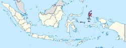 Location of North Maluku in Indonesia | |
| Coordinates: 0°47′N 127°22′E | |
| Capital | Sofifi |
| Largest city | Ternate |
| Government | |
| • Body | North Maluku Provincial Government |
| • Governor | Abdul Ghani Kasuba |
| • Vice Governor | Al Yasin Ali |
| Area | |
| • Total | 31,982.50 km2 (12,348.51 sq mi) |
| Area rank | 23rd in Indonesia |
| Population (mid 2019)[1] | |
| • Total | 1,235,700 |
| • Density | 39/km2 (100/sq mi) |
| Demographics | |
| • Religion | Islam (74.28%), Protestantism (24.9%), Roman Catholicism (0.52%) |
| • Languages | Indonesian (official), Ternate Malay (lingua franca) Ternate (regional), Galela (regional), Tobelo (regional) |
| Time zone | UTC+09 (Indonesia Eastern Time) |
| ISO 3166 code | ID-MU |
| HDI | |
| HDI rank | 27th (2017) |
| Website | malutprov.go.id |
North Maluku was originally the centre of the four largest Islamic sultanates in the eastern Indonesian archipelago—Bacan, Jailolo, Tidore and the Ternate—known as the Moloku Kie Raha (Four Mountain Sultanates). Upon Europeans' arrival at the beginning of the 16th century, North Maluku became the site of competition between the Portuguese, Spanish and the Dutch to control trade. In the end, the Dutch emerged victorious, beginning three centuries of Dutch rule in the region. The Japanese invaded the region during World War II, and Ternate became the center of the Japanese rule of the Pacific region. Following the Indonesia's independence, the region became a part of the province of Maluku.
The province of North Maluku was officially established on 12 October 1999. Ternate served as its de facto capital until 2010, when the provincial government moved to Sofifi. The movement of the regional economy in North Maluku is largely relies on the agricultural sector, fisheries and other types of marine products. The main commodities that support economic pulse in North Maluku include copra, nutmeg, cloves, fisheries, gold and nickel. North Maluku's natural products include rice, corn, roasted sweet potatoes, beans, coconut, potatoes, nutmeg, sago, and eucalyptus.
History
Etymology
Historically, the term Maluku referred to the four royal centers in North Maluku, namely Ternate, Tidore, Bacan and Jailolo. A type of confederation consisting of the four kingdoms, which most likely emerged in the 14th century, was called Moloku Kie Raha or "Four Mountains of Maluku".[4] Although the four kingdoms subsequently expanded and covered the entire North Maluku region (as now defined) and parts of Sulawesi and New Guinea, the area of expansion was originally not included in the term Maluku. This only referred to the four main clove-producing islands to the west of Halmahera: Ternate, Tidore. Moti and Makian. Bacan further to the south, and Jailolo on Halmahera, were also commonly included in Maluku Proper, the four kingdoms forming a ritual quadripartition with connotations to local cosmology.[5]
The etymology of the word Maluku is not very clear, and it has been a matter of debate for many experts.[6] A common theory says that the term Maluku originates from the Arabic phrase Jaziratul Muluk (جزيرة الملوك), which means "Country of the Kings" (muluk is the plural form of malik, which means king). Thus the kingless Ambon archipelago, the Banda archipelago and island groups to the south were at that time not included in the original sense of the term. However, the term is known in texts from the 14th century, before there was likely any significant Arab influence, putting this etymology in doubt.[7]
Precolonial era
The island of Ternate or Gapi began to bustle in the early 13th century. The early Ternate population was the result of an exodus from Halmahera. Initially there were four villages in Ternate, each headed by a momole (head of a clan). It was they who first made contact with merchants who came from all directions looking for spices. The population of Ternate became increasingly heterogeneous with settlements of Arab, Javanese, Malay and Chinese traders. Since the increasingly busy trading activities were coupled with threats that often came from pirates, the Momole Guna Tobona leaders held a conference to form a stronger organization and appoint a single leader as king.[8]
In 1257, according to traditional chronology, Momole Cico, Sampalu's leader was elected and appointed as the first kolano (king) with the title Baab Mashur Malamo (1257-1272).[9] The Kingdom of Gapi was centered in the village of Ternate, which later grew bigger and more crowded so that the population was also referred as Gam Lamo or the big village (later, people knew Gam Lamo as Gamalama). Ternate was the larger and more populous settlement on the island, so that people would call the kingdom Ternate rather than Gapi. Under the leadership of several generations of rulers, Ternate developed from a kingdom which only covered a small island, to becoming the largest and most influential realm in eastern Indonesia, especially the Moluccas. It was organized in settlement units called soa which stood under headmen or bobato. At the top, the kolano was assisted by four chief officials, dopolo ngaruha, led by a first minister or jogugu.[10]
Starting in the mid-15th century, Islam was adopted by the leading families in the kingdom, due to the influence of Muslim merchants from Java, India and the Malay World.[11] Some aspects of Islamic law were applied, though Islam was only patchily disseminated until the second half of the 16th century.[12] Sultan Zainal Abidin (r. 1486?-1500?) substituted the title of kolano with that of Sultan, following the template of rulership from the Malay World.[13] With this, Muslim scholars became important figures in the Ternate kingdom.
Opposite of Ternate lies the island of Tidore, the seat of the Kingdom of Tidore, or Duko. According to the genealogies of the kings of Ternate and Tidore, the first kolano of Tidore was Sahjati (Muhammad Naqil) who supposedly ascended the throne in 1081.[14] The ruler was known as Kië ma-kolano, "King of the Mountain". It was only at the end of the 15th century that Islam was adopted as the official religion of the kingdom. The 9th King of Tidore, Sultan Jamaluddin, chose to enter Islam thanks to the preaching of Sheikh Mansur from Arabia.[15] Of the other two kingdoms, Jailolo was reportedly the most powerful Malukan realm in the pre-European era although its powers vanished in the 16th century. Bacan had some importance as a link between the Austronesian and Papuan worlds in the 16th century, but also shrank to insignificance due to military setbacks and severe population decline in the 16th and early 17th centuries.[16]
Colonial era
The first European to land in the Moluccas was supposedly Ludovico di Varthema, an Italian explorer who claims to have visited the region in 1505. In 1512, the Portuguese set foot in Ternate for the first time under the leadership of Francisco Serrão. With the approval of Sultan Bayan Sirrullah, Portugal was allowed to establish a trading post in Ternate. Portugal came not only to share the trading opportunities, but to control the commerce in spices, nutmeg and cloves, in Maluku. For this reason, the white foreigners first had to subordinate Ternate. Their superior weaponry and possession of the trading entrepôt Melaka made them attractive as allies. But as soon as they were permanently established, the Europeans began to interfere in local politics. Simultaneously, Al-Mansur of Tidore (d. 1526) received the remnants of the Magellan expedition in 1521 and tried to secure the Spanish as allies, though the presence of Spain in Maluku turned out to be very limited up to 1582. Ternate and Tidore lived in a near-permanent state of rivalry during the 16th and 17th centuries, though there was also a ritual dualism in their relationship.[17]
Sultan Bayan Sirrullah died in 1521, leaving heirs who were still very young. The widow of the sultan, the Tidorese princess Nukila, and Prince Taruwese, son of the deceased sultan by a low-ranking wife, acted as guardians. Queen Mother Nukila intended to unite Ternate and Tidore under one crown, headed by one of her two sons, Pangeran Hidayat (later Sultan Dayalu) or prince Abu Hayat (later Sultan Abu Hayat II). Meanwhile Prince Tarruwese wanted the throne for himself.[18]
The Portuguese took advantage of this opportunity and pitted them against each other, resulting in civil strife. Queen Nukila's side was supported by Tidore while Prince Taruwese was supported by Portugal. After overcoming his adversary, Prince Taruwese was in turn betrayed and killed by the Portuguese.[19] The Portuguese captain acted as an adviser to the kingdom. Through his influence, the royal council was persuaded to appoint prince Tabariji as sultan in 1533. But when the Ternatans began to show hostility to Christianized regions in Halmahera, Tabariji was slandered and exiled to the Portuguese hub in Goa, India in 1535. There he was converted to Christianity and was later pushed to write a testament that bequeathed Ternate to the King of Portugal.[20] This made the next sultan Hairun a royal vassal of Portugal, but in fact he disregarded the testament and built up his power behind the backs of the Europeans.
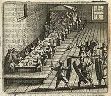
Portugal helped Hairun conquer the Jailolo kingdom in 1551, reducing it to a Ternate vassal.[21] However, the arrogant treatment of his brothers and himself caused the deep resentment of Sultan Hairun. He tried to weaken the Portuguese positions in Maluku, sending expeditions to attack the partly Christianized Ambon Island. The actions of the colonizers also caused anger among the people who stood behind the Sultan. In response, the Portuguese captain, Diogo Lopes de Mesquita invited Hairun for negotiations but brutally murdered the sultan who entered the fort without his bodyguards.[22]
The assassination of Sultan Hairun incited the people of Ternate to expel Portugal. Even other parts of the Moluccas chose to support the leadership and struggle of the new Sultan Baabullah. The fortresses of Portugal throughout Maluku and the eastern regions of Indonesia were attacked. After five years of war, the Portuguese were finally expelled from northern Maluku in 1575. Under the leadership of Sultan Baabullah, the power of Ternate reached its peak. His area of influence stretched from North and Central Sulawesi in the west to the Papuan Islands in the east, from the southern Philippines in the north to the Lesser Sunda Islands in the south. The Bacan sultanate, whose ruler had temporarily been converted to Christianity, was also forced to yield. However, the Portuguese held out in Ambon and established a fortress in Tidore in 1578, since the Tidorese Sultan Gapi Baguna began to fear Baabullah's ambitions.[23]
After the death of Sultan Baabullah, the sultanate began to weaken. The Spanish, who had united with Portugal in 1580, tried to regain control of Maluku by attacking Ternate via the Iberian base in Tidore. With Spain strengthening its position in the Philippines, Ternate formed an alliance with local Muslim lords in Mindanao to drive off the Spanish, but failed. Sultan Saidi Berkat defeated several invasion attempts, but was eventually captured by the Spaniards in 1606 and exiled to Manila. The Spanish-allied Tidore took over some Ternatan dependencies.[24]
Surviving Ternatan aristocrats requested the help of the Dutch, with whom they had entertained contacts since 1599. The Dutch responded and helped Sultan Mudafar Syah I to reestablish himself on Ternate Island. On 26 June 1607 the sultan signed a contract that gave the Dutch East India Company (VOC) monopoly in purchasing spices in his realm, in return for Dutch assistance against Spain.[25] In 1607, the Dutch also built the Fort Oranje on Ternate, which was their first stronghold in the archipelago. The VOC expelled the Spanish from most of Maluku in the following years, though Spain kept Tidore and Fort Gammalamo in Ternate until 1663. From the beginning, unhealthy and unbalanced relations between the Netherlands and Ternate caused dissatisfaction with the rulers and nobles of Ternate. Among them were Hidayat, a young Ambonese kimelaha (governor) who was also a former regent of Ternate and led the opposition against both Mudafar Syah and the Dutch. He ignored the Dutch trade monopoly agreement by selling spices to Javanese and Makassar traders. The resistance offered by him and his successors, and by the Muslim vassal state Hitu on Ambon, led to a long series of wars up to the 1650s where the VOC subjugated Ambon with Ternate's consent.[26]
Meanwhile, the Sultanate of Tidore succeeded in rejecting direct Dutch interference in their territory and remained a formally independent area until the end of the 18th century. Over the 17th century Tidore built up its positions in south-east Halmahera and Papua that yielded foodstuff, forest products and slaves.[27] At length, however, the VOC, which was a Dutch creation to control the commerce of the East Indies, succeeded in pacifying Ternate and Tidore. In its heyday, the VOC pursued an orderly, neat and controlling strategy, helped by a strong and flexible organization. Both Ternate and Tidore agreed to extirpate all clove trees in their realms in the 1650s, ensuring Dutch monopoly on clove cultivation. Because of the colonial policy, Maluku became an economic backwater after the mid-17th century. On the other hand, the rulers were able to strengthen their personal powers vis-à-vis their subjects under European protection. Ternate was reduced to a vassal of the VOC in 1682, and Tidore met the same fate in 1780.[28] The Tidorese prince Nuku led a successful anti-Dutch rebellion that encompassed much of Maluku and western Papua in 1780-1805. Helped by the British invasion in 1796-1803 he was able to push back the Dutch positions, but resistance collapsed after his death.[29] In the end, thus, Ternate and Tidore as well as other kingdoms in Maluku were incorporated in the Dutch colonial state. For more than a century after 1816, the archipelago remained under strict Dutch control, though the sultanates Ternate, Tidore and Bacan remained as zelfbesturende landschappen (self-ruling territories) until the Indonesian Revolution.[30]

Modern era
The Empire of Japan invaded Maluku early in 1942 as part of its Dutch East Indies Campaign of World War II, ousting the Dutch from the region. Halmahera became the site of a Japanese naval base at Kao Bay. 2 years later, US forces and their allies launched the Battle of Morotai in 1944; bombing the island in August and invading it in September. Imperial Japanese forces on Morotai held out until 1945 but failed to expel the Allied invaders. In the latter part of 1944, 61,000 personnel landed on Morotai.[31] Two thirds of them were engineers, who rapidly established facilities including harbors and two airstrips[31] plus extensive fuel stores. The formal surrender of the Second Japanese Army took place at Morotai on 9 September 1945. The last Japanese holdout from the war, Private Teruo Nakamura (Amis: Attun Palalin), was discovered by the Indonesian Air Force on Morotai, and surrendered to a search patrol on December 18, 1974.[32]
After the Japanese surrendered, the Dutch regained control of the region, before handing it over to the Indonesian government in 1949. In 1957, the Permesta movement was declared in Manado, North Sulawesi, aiming to overthrow the Indonesian government, The movement received support from the United States and Taiwan. In January 1958 the CIA began developing covert support networks to the PRRI and Permesta rebels. Supported by the American, Permesta forces captures Morotai and Halmahera as well as several islands. On May 1958 Indonesian National Armed Forces started to gather amphibious forces to retake both Morotai and the rebel-held town of Jailolo on the island of Halmahera.[33] By May 16 the assault fleet started to gather in Ambon harbour and on May 20 its troops landed on Morotai while élite Pasukan Gerak Tjepat (PGT or "Quick Reaction Force") troops parachuted onto the island.[34] The Permesta force's surrender was as quick as its capture of the island less than a month before.[34] It alarmed the Permesta rebels who had captured Jailolo, many of whom promptly fled back to North Sulawesi.[34] Thereafter the rebellion was largely confined to the Minahassa Peninsula of Sulawesi, where Permesta remnants waged a guerilla campaign until the last unit surrendered in January 1962.[35]

During the administration of President B. J. Habibie, the idea emerged to accelerate development in several potential regions by forming new provinces. Maluku is one of the potential areas for accelerating development through the expansion of the province, mainly because of the pace of development between the northern and southern regions and or between the middle and southeast regions that are not harmonious. On that basis, the government established North Maluku Province (with the temporary capital in Ternate) which was confirmed by Law Number 46 of 1999 concerning the division of North Maluku Province, Buru Regency and Tanimbar Islands Regency.[36]
North Maluku was also the site of the Maluku sectarian conflict. Although the area is more peaceful than the neighbouring Maluku province, there were several clashes between Christians and Muslims in Ternate and Halmahera. Several people were killed in Kao, Halmahera as residents of both faiths and Makianese Muslim migrants fought for three days, and the majority of sources state that the violence had started with the invasion of Sosol, one of the two villages destroyed by the Makianese gang.[37][38] A team of leaders was tasked with securing peace by the regional government, however no modifications were made to the redistricting decision and tension remained.[38] The conflict spread from Halmahera to neighbouring Ternate and Tidore. On 6 November 1999, a several-hundred strong Muslim gang, led by local Makianese political elite and thought to be mostly Makianese refugees, raged through Ternate attacking the Christian minority there also.[39] The police forces of Ternate were only able to guard their own institutions from attack, yet the traditional guards of the Sultan of Ternate, mostly composed of local Ternate Muslims, were particularly effective at protecting the local Christian population from attack.[40] The Sultan's guard had both established secure perimeters around areas of the city, including the mostly Chinese-owned business district, and physically stood between the mobs and possible victims in some cases and were later commended for preventing a potential massacre. At least 4 people died, however, and the Indonesian Navy later evacuated the several thousand Christian residents of both islands to Bitung and Manado in North Sulawesi.
The conflict was finally resolved after the Malino II Accord was signed by both parties.
Geography
The islands of North Maluku are mostly of volcanic origin, with the volcanoes of Dukono on Halmahera, Gamalama on Ternate still active and the whole of Tidore consisting of a large stratovolcano.
The North Maluku Islands are formed by the movement of three tectonic plates, namely Eurasia, the Pacific and Indo-Australia which have occurred since the time of lime. this movement formed the archipelago volcanic archipelago that stretched from north to south in western Halmahera, including Ternate Island, Tidore Island, Moti Island, Mare Island and Makian Island. Halmahera Island itself is a volcanic island even though volcanic activity occurs only in a part of its territory.
The islands have a tropical rainforest climate.
Ecology
The rainforests of Halmahera, Morotai, the Obi Islands, the Bacan islands and other islands of North Maluku have been described by the World Wildlife Fund as the Halmahera rain forests ecoregion and are home to a number of plant and animal species unique to the islands, which are in the Wallacea transition zone, containing a mixture of species of Asian and Australasian origin. The predominant trees of the forest are Anisoptera thurifera, Hopea gregaria, Hopea iriana, Shorea assamica, Shorea montigena, Shorea selanica, and Vatica rassak.
The endemic mammals found here include the Obi mosaic-tailed rat (Melomys obiensis), masked flying fox (Pteropus personatus), and four arboreal marsupials, the ornate (Phalanger ornatus), Rothschild's (P. rothschildi), blue-eyed (P. matabiru) and Gebe (P. alexandrae) cuscuses. There are over two hundred different birds on the islands, twenty-six of which are endemic, a large number for this small island group. The endemics include four birds which are the only species in their genera, including the elusive invisible rail (Habroptila wallacii), the white-streaked friarbird (Melitograis gilolensis), and two birds of paradise, the paradise-crow (Lycocorax pyrrhopterus) and Wallace's standardwing (Semioptera wallacii). The islands are also home to the largest bee in the world, Wallace's giant bee (Megachile pluto).[41]
Most of the natural forest remains on these mountainous islands, although much of the coastal and lowland areas have been cleared for clove-planting since the sixteenth century, especially on the islands of Ternate and Tidore. Logging has occurred more recently on Halmahera and Morotai.
The Sula Islands are part of the Sulawesi lowland rain forests ecoregion.[42]
Administrative divisions
North Maluku Province was subdivided into seven regencies and two autonomous cities. An eighth regency, covering Taliabu Island, was formed in 2013 from the westernmost island in the Sula Islands Residency. All are listed below with their areas and their populations at the 2010 and 2015 Censuses.[43]
| Name | Area (km2) | Population 2010 Census | Population 2015 Census | No. of Districts | Capital | HDI[44] 2014 Estimates |
|---|---|---|---|---|---|---|
| Ternate City | 111.4 | 185,705 | 212,527 | 7 | - | 0.771 (High) |
| Tidore Islands City | 1,645.7 | 90,055 | 96,910 | 8 | - | 0.667 (Medium) |
| Central Halmahera Regency (Halmahera Tengah) | 2,653.4 | 42,815 | 49,698 | 10 | Weda | 0.614 (Medium) |
| East Halmahera Regency (Halmahera Timur) | 6,571.4 | 73,109 | 84,970 | 10 | Maba | 0.632 (Medium) |
| Morotai Island Regency (Pulau Morotai) | 2,476.0 | 52,697 | 60,606 | 5 | Daruba | 0.583 (Low) |
| North Halmahera Regency (Halmahera Utara) | 3,896.9 | 161,847 | 179,783 | 17 | Tobelo | 0.641 (Medium) |
| South Halmahera Regency (Halmahera Selatan) | 8,148.9 | 198,911 | 219,559 | 30 | Labuha | 0.603 (Medium) |
| Sula Islands Regency (Kepulauan Sula) | 1,783.6 | 85,215 | 95,086 | 12 | Sanana | 0.601 (Medium) |
| Taliabu Island Regency (Pulau Taliabu) | 2,991.0 | 47,309 | 50,608 | 8 | Bobong | 0.573 (Low) |
| West Halmahera Regency (Halmahera Barat) | 1,704.2 | 100,424 | 110,528 | 8 | Jailolo | 0.620 (Medium) |
| Total Province | 31,982.5 | 1,038,087 | 1,160,275 | 115 | 0.651 (Medium) |
Economy
In the 2010s, efforts were undertaken to further develop the province. Governor Abdul Ghani Kasuba designated South Halmahera as a tourism region for the province,[45] inaugurating the Widi International Fishing Tournament for that purpose.[46] Kasuba also successfully negotiated with the China-based Jinchun Group to build a nine-trillion rupiah smelter in the Obi Islands.[47]
Demographics
Population
The population of North Maluku in mid 2019 was 1,235,700 people spread across 10 regencies and cities. South Halmahera Regency is the regency that has the largest population of 227,280 people in 2017 or 18.79% of the province's total population, followed by Ternate with 223,111 people in 2017, or 18.45%, while the regency that has the smallest population is Taliabu Island Regency with 51,928 people or just 4.29%. The population growth rate in North Maluku is 1.98% per year. Central Halmahera Regency is the region with the highest population growth rate of 2.92% per year, while the area with the lowest population growth rate is Tidore of 1.15% per year. With an area of 31,982 km² and a population of 1.2 million in 2017, the population density in North Maluku is 38 / km². The area with the highest density is Ternate with a density of 2,003 / km², while the region with the lowest density is East Halmahera Regency with a density of only 14 / km².
Ethnic groups
North Maluku has a very diverse population. In total there are around 28 ethnic groups and languages in North Maluku. They are divided into two families of languages based on the language used, namely Austronesian and Papuan. Austronesian groups live in the central and eastern parts of Halmahera. They include the Buli, Maba, Patani, Sawai and Weda peoples. North and West Halmahera are dominated by Papuan-speaking ethnic groups, i.e. Galela, Tobelo, Loloda, Tobaru, Modole, Togutil, Pagu, Waioli, Ibu, Sahu, Ternate and Tidore. In the Sula Islands, there are several ethnic groups such as the Kadai, Mange and Siboyo peoples. Most people in this area have a command of Ternate Malay.
Religion
Most of the population in North Maluku is Muslim, with Christians (mostly Protestants) a significant minority. Hinduism, Buddhism, and various other religions are practiced by a small part of the population. According to data in 2017, the composition of religion in this province is Islam 75.34%, Protestant 23.96%, Catholic 0.68%, Hinduism 0.01%, Buddhism 0.01%.[49]
Tourism
Maritime tourism in North Maluku is based on the area's islands and beaches with marine parks and various types of ornamental fish. There are also tourist forests as well as national parks with endemic species ranked 10th in the world. The nature reserve area consists of several types, both on land and in marine waters such as the Sibela Mountain Reserve on Bacan Island, Nature Reserve on Obi Island, Taliabu Nature Reserve on Taliabu Island and Nature Reserve on Seho Island. Cultural Heritage Areas that have archaeological historical values scattered in the North Maluku Province include cultural reserves in Ternate City, Tidore City, West Halmahera.
References
- Badan Pusat Statistik, Jakarta, 2019.
- Central Bureau of Statistics: Census 2010 Archived 2010-11-13 at the Wayback Machine, retrieved 17 January 2011 (in Indonesian)
- Badan Pusat Statistik, Jakarta, 2019.
- C.F. van Fraassen 1987 Ternate, de Molukken en de Indonesische Archipel. Leiden: Rijksmuseum te Leiden, Vol. I, p. 18.
- C.F. van Fraassen 1987, Vol. I, p. 18.
- Leonard Andaya 1993 The world of Maluku. Honolulu: University of Hawai'i Press, p. 47.
- Stuart Robson 1995 Desawarnana (Nagarakrtagama) by Mpu Prapañca. Leiden: KITLV Press, p. 34.
- Leonard Andaya 1993, p. 50.
- C.F. van Fraassen 1987, Vol. II, p. 1-2.
- Muridan Widjojo 2009 The revolt of Prince Nuku: Cross-cultural alliance-making in Maluku, c. 1780-1810. Leiden: Brill, p. 47-8.
- C.F. van Fraassen 1987, Vol. I, p. 32.
- Leonard Andaya 1993, p. 147.
- C.F. van Fraassen 1987, Vol. II, p. 4.
- Annie Nugraha 2017 "Tidore dalam balutan sejarah".
- P.J.B.C. Robidé van der Aa 1879 Reizen naar Nederlandsch Nieuw-Guinea. 's-Gravenhage: M. Nijhoff, p. 18.
- Leonard Andaya 1993, p. 130-2.
- Leonard Andaya 1993, p. 55, 115-6
- C.F. van Fraassen 1987, Vol. I, p. 38.
- P.A. Tiele 1879-1887 "De Europëers in den Maleischen Archipel", Bijdragen tot de Taal-, Land- en Volkenkunde 25-36, Part II:1, p. 9-10.
- Georg Schurhammer 1980 Francis Xavier: His Life, his times - vol. 3: Indonesia and India, 1545-1549. Rome: The Jesuits Historical Institute, p. 39-40.
- Leonard Andaya 1993, p. 130.
- P.A. Tiele 1877-1887, Part IV:5, p. 442.
- Leonard Andaya 1993, p. 132-7.
- Leonard Andaya 1993, p. 140-1.
- Peter Borschberg 2015 Journals, memorials and letters of Cornelis Matelieff de Jonge. Singapore: NUS Press, p. 87-9.
- J. Keuning 1988 "Ambonese, Portuguese and Dutchmen: the history of Ambon to the end of the seventeenth century", in M.A.P. Meilink-Roelofsz et al. (eds), Dutch authors on Asian history. Dordrecht: Foris, p. 379-92.
- Leonard Andaya 1993, p. 169-74.
- Leonard Andaya 1993, p. 167, 185-6; Muridan Widjojo 2009, p. 56.
- Muridan Widjojo 2009, p. 57-89.
- C.F. van Fraassen 1987, Vol. I, p. 57-62.
- Conboy & Morrison 1999, p. 102.
- "The Last Last Soldier?", Time, January 13, 1975.
- Conboy & Morrison 1999, p. 134.
- Conboy & Morrison 1999, p. 147.
- Conboy & Morrison 1999, p. 161.
- Lembaran Negara Tahun 1999 Nomor 174, Tambahan Lembaran Negera Nomor 3895
- Duncan, Christopher R. (October 2005). "The Other Maluku: Chronologies of Conflict in North Maluku". Indonesia. Southeast Asia Program Publications at Cornell University. 80 (80): 53–80. JSTOR 3351319.
- Braithwaite 2010, pp. 200–201
- Braithwaite 2010, pp. 202–203
- Braithwaite 2010, p. 214
- "Halmahera Rain Forests". Terrestrial Ecoregions. World Wildlife Fund.
- Wikramanayake, Eric; Eric Dinerstein; Colby J. Loucks; et al. (2002). Terrestrial Ecoregions of the Indo-Pacific: a Conservation Assessment. Washington, DC: Island Press.
- Badan Pusat Statistik, Jakarta, 2018.
- Indeks-Pembangunan-Manusia-2014
- Widi Islands to be the Future of North Maluku Tourism. Tempo, 21 May 2017. Accessed 18 September 2017.
- Aria Cindyara, N Maluku to boost maritime sector through fishing tourism. Antara, 24 August 2017. Accessed 30 August 2017.
- China`s Jinchun to in vest Rp9 trillion in North Maluku. Antara, 16 July 2016. Accessed 18 September 2017.
- "Population by Region and Religion in Indonesia". BPS. 2010.
- "Provinsi Maluku Utara Dalam Angka 2018"
Regencies and cities of North Maluku | ||
|---|---|---|
Capital: Sofifi | ||
| Regencies | ||
| Cities | ||
Capital: Jakarta | ||
| Sumatra |  | |
| Java | ||
| Kalimantan | ||
| Lesser Sunda | ||
| Sulawesi | ||
| Maluku | ||
| Papua | ||
Lists by
| ||