Mentawai Islands Regency
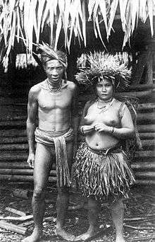
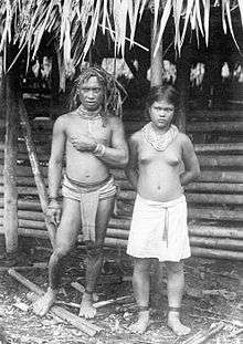
The Mentawai Islands Regency are a chain of about seventy islands and islets approximately 150 kilometres (93 miles) off the western coast of Sumatra in Indonesia. They cover 6,011.35 sq2 and had a population of 76,173 at the 2010 Census and 85,156 at the 2015 Census; the latest official estimate (as at mid 2019) is 93,070.[1] Siberut at 4,030 square kilometres (1,556 square miles) is the largest of the islands. The other major islands are Sipura, North Pagai (Pagai Utara) and South Pagai (Pagai Selatan). The islands lie off the Sumatran coast, across the Mentawai Strait. They cover The indigenous inhabitants of the islands are known as the Mentawai people. The Mentawai Islands have become a noted destination for surfing,[2] with over 40 boats offering surf charters to international guests.[3]
Mentawai Islands Regency Kabupaten Kepulauan Mentawai | |
|---|---|
Seal | |
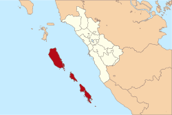 Location within West Sumatra | |
| Coordinates: 2°11′S 99°39′E | |
| Country | Indonesia |
| Province | West Sumatra |
| Regency seat | Tua Pejat |
| Government | |
| • Regent | Yudas Sabaggalet |
| • Vice Regent | Kortanius Sabeleake |
| Area | |
| • Total | 6,011.35 km2 (2,321.00 sq mi) |
| Population (mid 2019) | |
| • Total | 93,070 |
| • Density | 15/km2 (40/sq mi) |
| Time zone | UTC+7 (Indonesia Western Standard Time) |
| Area code | (+62) 759 |
| Website | mentawaikab.go.id |

Administration
The Mentawai Islands have been administered as a regency within the West Sumatra (Sumatera Barat) province since 1999. The regency seat is Tua Pejat, on the island of Sipora. Padang, the capital of the province, lies on the Sumatran mainland opposite Siberut. The regency is divided into ten districts (kecamatan), tabulated below from south to north with their 2010 census populations[4] and the 2013 estimates.[5]
| District | English Name | Area in km2 | Population 2010 Census | Population 2013 Estimate |
|---|---|---|---|---|
| Pagai Selatan | South Pagai | 901.08 | 8,782 | 9,106 |
| Sikakap | Central Pagai | 278.45 | 9,531 | 9,544 |
| Pagai Utara | North Pagai | 342.02 | 5,212 | 5,452 |
| Sipora Selatan | South Sipora | 268.47 | 8,460 | 8,653 |
| Sipora Utara | North Sipora | 383.08 | 9,097 | 11,579 |
| Siberut Selatan | South Siberut | 508.33 | 8,446 | 9,296 |
| Siberut Barat Daya | Southwest Siberut | 649.08 | 6,069 | 6,368 |
| Siberut Tengah | Central Siberut | 739.87 | 6,069 | 6,423 |
| Siberut Utara | North Siberut | 816.11 | 7,774 | 8,507 |
| Siberut Barat | West Siberut | 1,124.86 | 6,733 | 6,912 |
| Totals | 6,011.35 | 76,173 | 81,840 |
Villages
Administrative villages (desa) listed for each district:[6]
| District | Villages |
|---|---|
| Pagai Selatan | Bulasat, Makalo, Malakopa (Malakopak), Sinaka (Sinakak) |
| Pagai Utara | Betumonga, Saumanganya (Saumanganyak), Silabu |
| Siberut Barat | Sigapokna, Simalegi/Simaligi, Simatalu Sipokak |
| Siberut Barat Daya | Katurai/Katurei, Pasakiat Taileleu (Pasakiat Taleleu), Sagulubbeg (Sagulubek / Sagalubeg / Sagalubbek) |
| Siberut Selatan | Madobag (Madobak Ugai), Maileppet/Maleppet, Matotonan, Muara/Muaro Siberut, Muntei |
| Siberut Tengah | Cimpungan, Saibi Muara (Saibi Samukop/Samokop), Saliguma |
| Siberut Utara | Bojakan, Malancan (Malancang), Mongan Poula/Paula, Muara/Muaro Sikabaluan, Sirilogui, Sotboyak |
| Sikakap | Matobe (Matobek), Sikakap, Taikako |
| Sipora Selatan | Beriulou, Bosua, Mara, Matobe (Matobek), Nemnemleleu (Nem-Nem Leleu), Saureinu (Saureinuk), Sioban |
| Sipora Utara | Betumonga (Beutomonga), Bukit Pamewa, Gosooinan (Goisooinan), Sido Makmur, Sipora Jaya, Tuapejat |
Tourism
Surfing
Throughout the Mentawai Islands, you can expect rugged untouched tropical wilderness and an extensive range of waves for surfers scattered along the reefs that surround the many islands. The peak season of surf is from April to October, which attracts hardcore surfers. While the fringe seasons can be hit or miss with swells, however, provides fewer crowds in the water and smaller surf for less capable surfers. The Mentawai Islands is a popular surf destination among most surfers.[7]
Ecology
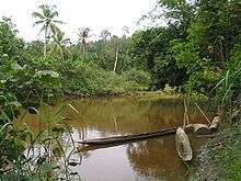

The islands have been separated from Sumatra since the mid-Pleistocene period, which has allowed at least twenty endemic species to develop amongst its flora and fauna. This includes six endemic primates: the Kloss's gibbon (Hylobates klossii), Mentawai macaque (Macaca pagensis), Siberut macaque (Macaca siberu), Mentawai langur (Presbytis potenziani), Siberut langur (Presbytis siberu), and pig-tailed langur (Simias concolor). They are highly endangered due to logging, unsustainable hunting, and conversion of rainforest to palm oil plantations.[8] Some areas of the Mentawai Islands rainforest ecoregion are protected, such as the Siberut National Park. Red junglefowl, the Asian palm civet and crab-eating macaque are also native.[9]
Seismic activity
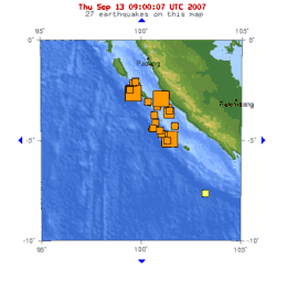
The Mentawai Islands lie above the Sunda megathrust, a seismically active zone responsible for many great earthquakes. This megathrust runs along the southwestern side of Sumatra island, forming the interface between the Eurasian Plate and Indo-Australian Plate.
Earthquake and tsunami activity has been high since the 2004 Indian Ocean earthquake. In 1833, the region was hit with an earthquake, possibly similar in size to the 2004 Indian Ocean earthquake;[10] another large earthquake struck in 1797. On October 25, 2010, an earthquake in southern Sumatra led to a deadly tsunami that devastated villages in South and North Pagai.[11] On March 3, 2016, an earthquake of 7.8 magnitude occurred off the Indian Ocean, a few hundred kilometres from Mentawai islands, as a result of strike-slip faulting within the oceanic lithosphere of the Indo-Australia plate.[12]
See also
- Mentawai ethnic group
- Mentawai Festival
Notes
- Badan Pusat Statistik, Jakarta, 2019.
- "SURFAID". SURFAID. Archived from the original on May 17, 2014. Retrieved May 3, 2017.
- "Every Surf Charter Boat in the Mentawais | 41 Boats with Photos and Info". Indies Trader. Retrieved 2019-05-05.
- Biro Pusat Statistik, Jakarta, 2011.
- Badan Pusat Statistik, Jakarta, 2015.
- "Daftar Desa & Kelurahan di Kabupaten Kepulauan Mentawai". www.nomor.net. Kode Pos Indonesia. 2020. Retrieved 2020-02-25.
- "Mentawai Islands Surf Spots". Surf Indonesia. Retrieved 2019-06-25.
- Whittaker, D. 2006. A conservation action plan for the Mentawai primates. Primate Conservation 20: 95–105.
- "Mentawai Islands rain forests". Terrestrial Ecoregions. World Wildlife Fund.
- "INDONESIA - THE GREAT EARTHQUAKE AND TSUNAMI OF 1833 OFF THE COAST OF CENTRAL SUMATRA - Dr. George Pararas-Carayannis". www.DrGeorgePC.com. Retrieved May 3, 2017.
- "Indonesia Earthquake and Tsunami Kill 113, Merapi Volcano Eruptions Hours Later". News article. politiktimes.com. October 26, 2010. Archived from the original on November 5, 2010. Retrieved October 26, 2010.
- "M7.8 – Southwest of Sumatra, Indonesia". Retrieved March 2, 2016.
External links
| Wikimedia Commons has media related to Mentawai Islands Regency. |

| Authority control |
|
|---|