Huila Department
Huila (Spanish pronunciation: [ˈwila]) is one of the departments of Colombia. It is located in the southwest of the country, and its capital is Neiva.[3]
Department of Huila Departamento del Huila | |
|---|---|
 Flag  Coat of arms | |
| Anthem: Alma del Huila (Huila's soul) | |
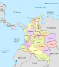
.svg.png) Huila shown in red | |
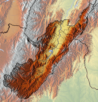 Topography of the department | |
| Coordinates: 2°59′55″N 75°18′16″W | |
| Country | |
| Region | Andean Region |
| Established | 1905 |
| Capital | Neiva |
| Government | |
| • Governor | Carlos Julio Gonzalez Villa (2016-2019) |
| Area | |
| • Total | 19,890 km2 (7,680 sq mi) |
| Area rank | 26th |
| Population (2018)[1] | |
| • Total | 1,100,386 |
| • Rank | 15th |
| • Density | 55/km2 (140/sq mi) |
| Time zone | UTC-05 |
| ISO 3166 code | CO-HUI |
| Provinces | 4 |
| Municipalities | 37 |
| HDI (2017) | 0.709[2] high · 21st |
| Website | www.gobhuila.gov.co |
Geography
| Historical population | ||
|---|---|---|
| Year | Pop. | ±% |
| 1973 | 467,651 | — |
| 1985 | 693,712 | +48.3% |
| 1993 | 843,798 | +21.6% |
| 2005 | 1,011,418 | +19.9% |
| 2018 | 1,100,386 | +8.8% |
| Source:[4] | ||
The south of the department is located in the Colombian Massif. The Cordillera Oriental is born in this place.
Colombia's third highest peak, the Nevado del Huila volcano, is located in Huila department.
The Magdalena River (also called Yuma River) is Colombia's largest river, rises in Huila department. Some of Huila's most important towns are placed in the Magdalena River Valley. Betania is a dam located in the Magdalena river. A bigger dam, El Quimbo, is planned for the same river.
Administrative divisions
Municipalities
- Acevedo
- Agrado
- Aipe
- Algeciras
- Altamira
- Baraya
- Campoalegre
- Colombia
- Elias
- Garzón
- Gigante
- Guadalupe
- Hobo
- Iquira
- Isnos
- La Argentina
- La Plata
- Nataga
- Neiva (Capital City)
- Oporapa
- Paicol
- Palermo
- Palestina
- Pital
- Pitalito
- Rivera
- Saladoblanco
- San Agustín
- Santa María
- Suaza
- Tarqui
- Tello
- Teruel
- Tesalia
- Timaná
- Villavieja
- Yaguará
References
- "DANE". Archived from the original on November 13, 2009. Retrieved February 13, 2013.
- "Sub-national HDI - Area Database - Global Data Lab". hdi.globaldatalab.org. Retrieved 2018-09-13.
- "Generalidades del departamento". Gobernación del Huila. Retrieved 26 April 2013.
- "Reloj de Población". DANE. Departamento Administrativo Nacional de Estadísitica. Archived from the original on 16 January 2018. Retrieved 6 July 2017.
This article is issued from Wikipedia. The text is licensed under Creative Commons - Attribution - Sharealike. Additional terms may apply for the media files.