Sola
Sola is a municipality in Rogaland county, Norway. It is located in the traditional district of Jæren. The administrative centre of the municipality is the village of Solakrossen. Other villages include Tananger, Hålandsmarka, Sørnes, and Stenebyen. Stavanger Airport is located in Sola, just a short distance from the large Stavanger/Sandnes metropolitan area.
Sola kommune | |
|---|---|
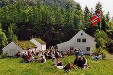
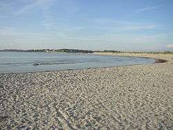 View of a beach in Sola | |
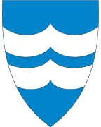 Coat of arms  Rogaland within Norway | |
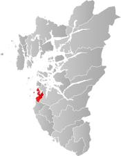 Sola within Rogaland | |
| Coordinates: 58°52′48″N 05°37′43″E | |
| Country | Norway |
| County | Rogaland |
| District | Jæren |
| Administrative centre | Solakrossen |
| Government | |
| • Mayor (2011) | Ole Ueland[1] (H) |
| Area | |
| • Total | 69.04 km2 (26.66 sq mi) |
| • Land | 68.82 km2 (26.57 sq mi) |
| • Water | 0.22 km2 (0.08 sq mi) |
| Area rank | 402 in Norway |
| Population (2017) | |
| • Total | 26,016 |
| • Rank | 41 in Norway |
| • Density | 378/km2 (980/sq mi) |
| • Change (10 years) | 25.9% |
| Demonym(s) | Solabu[2] |
| Time zone | UTC+01:00 (CET) |
| • Summer (DST) | UTC+02:00 (CEST) |
| ISO 3166 code | NO-1124 |
| Official language form | Neutral[3] |
| Website | www |
The 69-square-kilometre (27 sq mi) municipality is the 402nd largest by area out of the 422 municipalities in Norway. Sola is the 41st most populous municipality in Norway with a population of 26,016. The municipality's population density is 378 inhabitants per square kilometre (980/sq mi) and its population has increased by 25.9% over the last decade.[4]
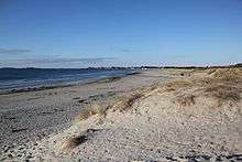
In the western part of Sola, there are 5 kilometres (3.1 mi) of long, sandy beaches facing the North Sea. With usually ample supplies of wind and waves, the sandy beaches are a popular place for windsurfing.
General information
The municipality of Sola was established in 1930 when the old municipality of Håland was split into Sola (south of the Hafrsfjorden) and Madla (north of the Hafrsfjorden). Initially, Sola had 3,372 residents.[5] On 1 January 2017, a small 350-decare (86-acre) area on the southwestern edge of the village of Solakrossen was transferred from Sandnes municipality to Sola.[6]
Name
The municipality (originally the parish) is named after the old Sola farm (Old Norse: Sóli), since the first Sola Church was built there. The name is very old and the meaning is unknown, although it contains the Norse word sól which translates as Sun, therefore it could have some link to the sun. Historically, the name was also spelled Sole.[7]
Coat-of-arms
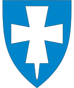
The coat-of-arms is from modern times; they were granted on 1982. The arms show two silver or white waves on a blue background. The arms symbolize all of the sandy beaches along the ocean in the municipality.[8]
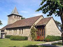
Churches
The Church of Norway has four parishes (sokn) within the municipality of Sola. It is part of the Tungenes deanery in the Diocese of Stavanger.
| Parish (Sokn) | Church Name | Location of the Church | Year Built |
|---|---|---|---|
| Ræge | Ræge Church | Ræge (north of Stenebyen) | 2009 |
| Sola | Sola Church | Solakrossen | 1955 |
| Sola Ruin Church | Nordsjøvegen | 1150 | |
| Sørnes | Sørnes Church | Sørnes | 1977 |
| Tananger | Tananger Church | Tananger | 2002 |
| Tananger Chapel | Tananger | 1879 |
Geography
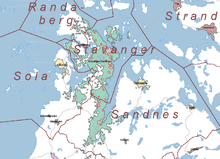
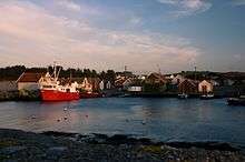
The municipality of Sola lies on the west side of the Stavanger Peninsula, south of the Hafrsfjorden. The municipality sits just about 5 kilometres (3.1 mi) from the centres of the cities of Stavanger and Sandnes. The island of Rott lies just off the western coast of Sola. The Fladholmen Lighthouse lies just off shore of the village of Tananger in northern Sola.[9]
History
| Historical population | ||
|---|---|---|
| Year | Pop. | ±% |
| 1951 | 5,025 | — |
| 1961 | 7,075 | +40.8% |
| 1971 | 9,898 | +39.9% |
| 1981 | 12,673 | +28.0% |
| 1991 | 15,982 | +26.1% |
| 2001 | 19,023 | +19.0% |
| 2011 | 23,350 | +22.7% |
| 2016 | 26,096 | +11.8% |
| Source: Statistics Norway.[10] | ||
According to Snorre Sturlason the Battle of Hafrsfjord took place in the year AD 872, probably outside Ytraberget. Harald Fairhair, the first king of Norway, is celebrated for having united Norway at this notable battle.
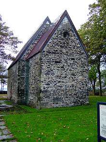
The stone crosses at Tjora date from about the year 1150. In early Christian times, these stone crosses were used as gathering points for religious ceremonies before churches were built. Sola Church Ruins (Sola ruinkirke) is the ruins of a Romanesque stone church dating from about the year 1120. The stone church probably replaced an older wooden church in the area. This wooden church was possibly the one that Erling Skjalgsson had built when he converted to Christianity at the end of the 10th century. Sola Church overlooked the Hafrsfjord and was in use until 1842.The artist Johan Bennetter (1822–1904) used the church as a studio and lived there with his family. During World War II, most of the church was demolished. It was later reconstructed, and the restoration was finished in 1995.[11][12]
Stavanger Airport, Sola was founded in 1937. At Sola airport, the first opposed landing by paratroopers took place as German Fallschirmjägers from 1st battalion of the 1st Regiment, 7th Flieger Division were dropped on the airfield. Sola Air Station became an important airfield for the Germans during World War II.
Government
All municipalities in Norway, including Sola, are responsible for primary education (through 10th grade), outpatient health services, senior citizen services, unemployment and other social services, zoning, economic development, and municipal roads. The municipality is governed by a municipal council of elected representatives, which in turn elect a mayor.
Municipal council
The municipal council (Kommunestyre) of Sola is made up of 41 representatives that are elected to four year terms. Currently, the party breakdown is as follows:[13]
| Party Name (in Norwegian) | Number of representatives | |
|---|---|---|
| Labour Party (Arbeiderpartiet) | 7 | |
| Progress Party (Fremskrittspartiet) | 7 | |
| Green Party (Miljøpartiet De Grønne) | 1 | |
| Conservative Party (Høyre) | 16 | |
| Christian Democratic Party (Kristelig Folkeparti) | 4 | |
| Centre Party (Senterpartiet) | 2 | |
| Liberal Party (Venstre) | 2 | |
| Local List(s) (Lokale lister) | 2 | |
| Total number of members: | 41 | |
Attractions
Museums
Museums in Sola include:
- The Aviation History Museum
- Rogaland Krigshistorisk Museum, a World War II museum
- Kystkultursamlingen i Tananger, a Maritime collection
References
- "Ordfører" (in Norwegian). Sola kommune.
- "Navn på steder og personer: Innbyggjarnamn" (in Norwegian). Språkrådet.
- "Forskrift om målvedtak i kommunar og fylkeskommunar" (in Norwegian). Lovdata.no.
- Statistisk sentralbyrå (2017). "Table: 06913: Population 1 January and population changes during the calendar year (M)" (in Norwegian). Retrieved 2017-11-02.
- Jukvam, Dag (1999). "Historisk oversikt over endringer i kommune- og fylkesinndelingen" (PDF) (in Norwegian). Statistisk sentralbyrå.
- "Vedtak om endring av kommunegrensen mellom Sandnes og Sola kommuner, Rogaland" (in Norwegian). Lovdata.no. Retrieved 2017-11-02.
- Rygh, Oluf (1915). Norske gaardnavne: Stavanger amt (in Norwegian) (10 ed.). Kristiania, Norge: W. C. Fabritius & sønners bogtrikkeri. pp. 185–186.
- "Civic heraldry of Norway - Norske Kommunevåpen". Heraldry of the World. Retrieved 2016-05-25.
- Store norske leksikon. "Sola – kommune" (in Norwegian). Archived from the original on 2016-06-25. Retrieved 2016-05-25.
- Projected population - Statistics Norway
- "Sola Ruinkirke". Kirkebøker. Retrieved September 1, 2016.
- "Johan Jakob Bennetter, norsk marinemaler, (1822–1904)". Salmonsens konversationsleksikon. Retrieved September 1, 2016.
- "Table: 04813: Members of the local councils, by party/electoral list at the Municipal Council election (M)" (in Norwegian). Statistics Norway. 2015.
External links


- Municipal fact sheet from Statistics Norway (in Norwegian)
 |
|  | |||||||||||||||||||||||||
||