List of earthquakes in 2015
This is a list of earthquakes in 2015. Only earthquakes of magnitude 6 or above are included, unless they result in damage and/or casualties, or are notable for some other reason. All dates are listed according to UTC (Coordinated Universal Time) time. This year was dominated by the earthquake in Nepal in April, with around 9,000 deaths. Another deadly event struck Afghanistan, while the strongest quake (8.3) took place in Chile, like in 2014. Malaysia was struck by a 6.0 earthquake which killed 18 climbers including Singaporean students. It is marked as the deadliest in the country.
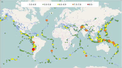
.svg.png) Approximate epicenters of the earthquakes in 2015
| |||
| Strongest magnitude | 8.3 Mw, | ||
|---|---|---|---|
| Deadliest | 7.8 Mw, 8,964 deaths[1] | ||
| Total fatalities | 9,635 | ||
| Number by magnitude | |||
| 9.0+ | 0 | ||
| 8.0−8.9 | 1 | ||
| 7.0−7.9 | 18 | ||
| 6.0−6.9 | 124 | ||
| 5.0−5.9 | 1,413 | ||
| 4.0−4.9 | 13,239 | ||
Compared to other years
| Magnitude Ranging Between | 2005 | 2006 | 2007 | 2008 | 2009 | 2010 | 2011 | 2012 | 2013 | 2014 | 2015 |
|---|---|---|---|---|---|---|---|---|---|---|---|
| 8−9.9 | 1 | 2 | 4 | 0 | 1 | 1 | 1 | 2 | 2 | 1 | 1 |
| 7−7.9 | 10 | 9 | 14 | 12 | 16 | 21 | 19 | 15 | 17 | 11 | 18 |
| 6−6.9 | 140 | 142 | 178 | 168 | 144 | 151 | 204 | 129 | 125 | 144 | 124 |
| 5−5.9 | 1693 | 1712 | 2074 | 1768 | 1896 | 1963 | 2271 | 1412 | 1402 | 1577 | 1413 |
| Total | 1844 | 1865 | 2270 | 1948 | 2057 | 2136 | 2495 | 1558 | 1546 | 1733 | 1556 |
Note that an increase in detected earthquake numbers does not necessarily represent an increase in earthquakes per se. Population increase, habitation spread, and advances in earthquake detection technology all contribute to higher earthquake numbers being recorded over time. USGS's Earthquake Myths has more information.
For exact dates and live earthquakes please visit USGS's Global Earthquake Search Page and Real-time Earthquake Map or EMSC's Real-time Seismicity.
2015
By death toll
| Rank | Death toll | Magnitude | Location | Depth (km) | MMI | Date |
|---|---|---|---|---|---|---|
| 1 | 8,964[1][2][3][4] | 7.8 | 15.0 | IX (Violent) | April 25 | |
| 2 | 399[5] | 7.5 | 231.0 | VII (Very strong) | October 26 | |
| 3 | 218[1] | 7.3 | 15.0 | VIII (Severe) | May 12 | |
| 4 | 18[6] | 6.0 | 10.0 | VI (Strong) | June 4 | |
| 5 | 14[7] | 8.3 | 20.7 | VIII (Severe) | September 16 |
- Note: At least 14 deaths
By magnitude
| Rank | Magnitude | Death toll | Location | Depth (km) | MMI | Date |
|---|---|---|---|---|---|---|
| 1 | 8.3 | 14 | 20.7 | VIII | September 16 | |
| 2 | 7.8 | 8,964 | 15.0 | IX | April 25 | |
| 2 | 7.8 | 0 | 677.6 | VII | May 30 | |
| 4 | 7.6 | 0 | 600.6 | IV | November 24 | |
| 4 | 7.6 | 0 | 611.7 | IV | November 24 | |
| 6 | 7.5 | 0 | 41.0 | VII | March 29 | |
| 6 | 7.5 | 0 | 41.5 | VII | May 5 | |
| 6 | 7.5 | 399 | 231.0 | VII | October 26 | |
| 9 | 7.3 | 218 | 15.0 | VIII | May 12 | |
| 10 | 7.2 | 2[8] | 26.0 | VII | December 7 | |
| 11 | 7.1 | 0 | Northern Mid-Atlantic Ridge | 16.7 | I | February 13 |
| 11 | 7.1 | 0 | 23.2 | VI | May 7 | |
| 11 | 7.1 | 0 | 127.0 | VI | October 20 | |
| 11 | 7.1 | 0 | Southeast Indian Ridge | 10.0 | I | December 4 |
| 15 | 7.0 | 0 | 552.1 | VI | February 27 | |
| 15 | 7.0 | 0 | Southern Mid-Atlantic Ridge | 10.0 | I | June 17 |
| 15 | 7.0 | 0 | 10.0 | VI | July 18 | |
| 15 | 7.0 | 1[9] | 48.0 | VII | July 27 | |
| 15 | 7.0 | 0 | 30.9 | VII | September 16 |
- Note: At least 7.0 magnitude
By month
January
| Strongest magnitude | 6.8 Mw, |
|---|---|
| Number by magnitude | |
| 8.0−8.9 | 0 |
| 7.0−7.9 | 0 |
| 6.0−6.9 | 4 |
| 5.0−5.9 | 117 |
| 4.0−4.9 | 1055 |


February
| Strongest magnitude | 7.1 Mw, Mid-Atlantic Ridge |
|---|---|
| Number by magnitude | |
| 8.0−8.9 | 0 |
| 7.0−7.9 | 2 |
| 6.0−6.9 | 10 |
| 5.0−5.9 | 110 |
| 4.0−4.9 | 970 |

- A magnitude 7.1 earthquake struck the Northern Mid-Atlantic Ridge on February 13 at a depth of 16.7 km (10.4 mi).[18]


March
| Strongest magnitude | 7.5 Mw, |
|---|---|
| Number by magnitude | |
| 8.0−8.9 | 0 |
| 7.0−7.9 | 1 |
| 6.0−6.9 | 11 |
| 5.0−5.9 | 100 |
| 4.0−4.9 | 1010 |
- A magnitude 6.0 earthquake struck the Mid-Indian Ridge on March 6 at a depth of 10.0 km (6.2 mi).[31]


April
| Strongest magnitude | 7.8 Mw, |
|---|---|
| Deadliest | 7.8 Mw, 8,964 deaths |
| Total fatalities | 8,965 |
| Number by magnitude | |
| 8.0−8.9 | 0 |
| 7.0−7.9 | 1 |
| 6.0−6.9 | 14 |
| 5.0−5.9 | 96 |
| 4.0−4.9 | 1047 |


.svg.png)

May
| Strongest magnitude | 7.8 Mw, |
|---|---|
| Deadliest | 7.3 Mw, 218 deaths |
| Total fatalities | 218 |
| Number by magnitude | |
| 8.0−8.9 | 0 |
| 7.0−7.9 | 4 |
| 6.0−6.9 | 17 |
| 5.0−5.9 | 155 |
| 4.0−4.9 | 1376 |
- A magnitude 6.7 earthquake struck the Pacific-Antarctic Ridge on May 19 at a depth of 7.2 km (4.5 mi).[71]
- A magnitude 6.3 earthquake struck the Southern Mid-Atlantic Ridge on May 24 at a depth of 10.0 km (6.2 mi).[76]

June
| Strongest magnitude | 7.0 Mw, Mid-Atlantic Ridge |
|---|---|
| Deadliest | 6.0 Mw, 18 deaths |
| Total fatalities | 18 |
| Number by magnitude | |
| 8.0−8.9 | 0 |
| 7.0−7.9 | 1 |
| 6.0−6.9 | 9 |
| 5.0−5.9 | 93 |
| 4.0−4.9 | 1013 |

- A magnitude 7.0 earthquake struck the Southern Mid-Atlantic Ridge on June 17 at a depth of 10.0 km (6.2 mi).[87]
July
| Strongest magnitude | 7.0 Mw, 7.0 Mw, |
|---|---|
| Deadliest | 6.4 Mw, 3 deaths 5.1 Mw, 3 deaths |
| Total fatalities | 7 |
| Number by magnitude | |
| 8.0−8.9 | 0 |
| 7.0−7.9 | 2 |
| 6.0−6.9 | 8 |
| 5.0−5.9 | 126 |
| 4.0−4.9 | 1150 |


August
| Strongest magnitude | 6.6 Mw, |
|---|---|
| Deadliest | 5.8 Mw, 1 death |
| Total fatalities | 1 |
| Number by magnitude | |
| 8.0−8.9 | 0 |
| 7.0−7.9 | 0 |
| 6.0−6.9 | 6 |
| 5.0−5.9 | 110 |
| 4.0−4.9 | 1059 |


September
| Strongest magnitude | 8.3 Mw, |
|---|---|
| Deadliest | 8.3 Mw, 14 deaths |
| Total fatalities | 14 |
| Number by magnitude | |
| 8.0−8.9 | 1 |
| 7.0−7.9 | 1 |
| 6.0−6.9 | 22 |
| 5.0−5.9 | 180 |
| 4.0−4.9 | 1608 |
- A magnitude 6.0 earthquake struck the Northern Mid-Atlantic Ridge on September 18 at a depth of 10.0 km (6.2 mi).[135]
October
| Strongest magnitude | 7.5 Mw, |
|---|---|
| Deadliest | 7.5 Mw, 399 deaths |
| Total fatalities | 400 |
| Number by magnitude | |
| 8.0−8.9 | 0 |
| 7.0−7.9 | 2 |
| 6.0−6.9 | 5 |
| 5.0−5.9 | 85 |
| 4.0−4.9 | 1136 |
- A magnitude 6.1 earthquake struck the Pacific-Antarctic Ridge on October 11 at a depth of 10.0 km (6.2 mi).[144]


November
| Strongest magnitude | 7.6 Mw, 7.6 Mw, |
|---|---|
| Deadliest | 6.5 Mw, 2 deaths 5.5 Mw, 2 deaths |
| Total fatalities | 6 |
| Number by magnitude | |
| 8.0−8.9 | 0 |
| 7.0−7.9 | 2 |
| 6.0−6.9 | 14 |
| 5.0−5.9 | 136 |
| 4.0−4.9 | 1204 |


December
| Strongest magnitude | 7.2 Mw, |
|---|---|
| Deadliest | 6.3 Mw, 4 deaths |
| Total fatalities | 6 deaths |
| Number by magnitude | |
| 8.0−8.9 | 0 |
| 7.0−7.9 | 2 |
| 6.0−6.9 | 7 |
| 5.0−5.9 | 105 |
| 4.0−4.9 | 608 |
- A magnitude 7.1 earthquake struck the Southeast Indian Ridge on December 4 at a depth of 35.0 km (21.7 mi).[183]

- A magnitude 6.2 earthquake struck the southern East Pacific Rise on December 24 at a depth of 12.3 km (7.6 mi).[190]
References
- "Incident Report of Earthquake 2015". Nepal Disaster Risk Reduction Portal. drrportal.gov.np. Retrieved 28 May 2015.
- "Quake toll in India now 78". Zee News. 29 April 2015. Retrieved 4 May 2015.
- "4 killed, 18 Bangladesh districts affected in earthquake, says govt". Bdnews24.com. Retrieved 26 April 2015.
- "25 dead, 383 injured in Tibet following Nepal earthquake". Xinhua. 28 April 2015. Retrieved 5 May 2015.
- "The Latest: UN Mobilizing to Aid Quake Victims". ABC News. Associated Press. 26 October 2015. Retrieved 26 October 2015.
- "Sabah quake: Death toll rises to 18; Malaysia to end search and rescue ops". The Straits Times. 10 June 2015. Retrieved 10 June 2015.
- "Onemi: aumentan a 13 los muertos y a seis los desaparecidos" (in Spanish). La Tercera. September 18, 2015. Retrieved September 19, 2015.
- "At least two dead in earthquake in Tajikistan". The Express Tribune. Karachi. Agence France-Presse. December 8, 2015. Retrieved December 8, 2015.
- "Teenager killed, buildings damaged after powerful earthquake hits near Jayapura, Indonesia". ABC News (Australia). Agence France Presse. 27 July 2015. Retrieved 28 July 2015.
- "M6.5 - 236km S of Punta de Burica, Panama". United States Geological Survey. January 7, 2015. Retrieved January 7, 2015.
- "M5.3 - 14km NNW of Shaping, China". United States Geological Survey. January 14, 2015. Retrieved January 14, 2015.
- "Earthquake injured at least 11 people". Xinhua News Agency. January 14, 2015. Retrieved January 14, 2015.
- "M6.8 - 80km NNE of Port-Vila, Vanuatu". United States Geological Survey. January 23, 2015. Retrieved January 23, 2015.
- "M6.2 - 54km SE of Ndoi Island, Fiji". United States Geological Survey. January 28, 2015. Retrieved January 28, 2015.
- "M6.0 - 209km SSE of Isangel, Vanuatu". United States Geological Survey. January 30, 2015. Retrieved January 30, 2015.
- "M6.3 - 91km NW of La Punta, Argentina". United States Geological Survey. February 2, 2015. Retrieved February 2, 2015.
- "M6.7 - 102km W of El Aguilar, Argentina". United States Geological Survey. February 11, 2015. Retrieved February 12, 2015.
- "M7.1 - Northern Mid-Atlantic Ridge". United States Geological Survey. February 13, 2015. Retrieved February 13, 2015.
- "M6.2 - 31km ESE of Taitung City, Taiwan". United States Geological Survey. February 13, 2015. Retrieved February 13, 2015.
- "M6.2 - 146km NNW of Visokoi Island, South Georgia and the South Sandwich Islands". United States Geological Survey. February 17, 2015. Retrieved February 17, 2015.
- "M6.7 - 83km ENE of Miyako, Japan". United States Geological Survey. February 17, 2015. Retrieved February 17, 2015.
- "M6.1 - 187km W of Lata, Solomon Islands". United States Geological Survey. February 18, 2015. Retrieved May 1, 2015.
- "M6.4 - 85km ESE of Lakatoro, Vanuatu". United States Geological Survey. February 19, 2015. Retrieved February 19, 2015.
- "M6.2 - 141km E of Miyako, Japan". United States Geological Survey. February 20, 2015. Retrieved February 20, 2015.
- "M6.0 - 133km E of Miyako, Japan". United States Geological Survey. February 21, 2015. Retrieved February 21, 2015.
- "M6.2 - 218km SW of Tomatlan, Mexico". United States Geological Survey. February 22, 2015. Retrieved February 22, 2015.
- "M5.4 - 22km E of Batgram, Pakistan". United States Geological Survey. February 26, 2015. Retrieved November 21, 2015.
- "15 people injured as strong earthquake jolts northern Pakistan | Pakistan | Dunya News". dunyanews.tv. Retrieved 2016-12-21.
- "M7.0 - 130km N of Nebe, Indonesia". United States Geological Survey. February 27, 2015. Retrieved February 27, 2015.
- "M6.1 - 48km NW of Sikabaluan, Indonesia". United States Geological Survey. March 3, 2015. Retrieved March 3, 2015.
- "M6.0 - Mid-Indian Ridge". United States Geological Survey. March 6, 2015. Retrieved May 19, 2015.
- "M6.2 - 9km NNE of Aratoca, Colombia". United States Geological Survey. March 10, 2015. Retrieved March 10, 2015.
- "M6.1 - 70km NW of Luwuk, Indonesia". United States Geological Survey. March 15, 2015. Retrieved May 1, 2015.
- "M6.2 - 135km NW of Kota Ternate, Indonesia". United States Geological Survey. March 17, 2015. Retrieved March 17, 2015.
- "M6.2 - 75km NNW of Talcahuano, Chile". United States Geological Survey. March 18, 2015. Retrieved March 18, 2015.
- "M6.4 - 45km ESE of Putre, Chile". United States Geological Survey. March 23, 2015. Retrieved March 23, 2015.
- "M7.5 - 53km SE of Kokopo, Papua New Guinea". United States Geological Survey. March 29, 2015. Retrieved March 29, 2015.
- Kristen Gelineau (March 29, 2015). "Small tsunami generated after earthquake strikes off Papua New Guinea". Sydney: CTV News. Associated Press. Retrieved May 5, 2015.
- "M6.0 - 94km NE of Hihifo, Tonga". United States Geological Survey. March 30, 2015. Retrieved May 19, 2015.
- "M6.4 - 106km NE of Hihifo, Tonga". United States Geological Survey. March 30, 2015. Retrieved March 30, 2015.
- "M6.5 - 91km ENE of Hihifo, Tonga". United States Geological Survey. March 30, 2015. Retrieved March 30, 2015.
- "M6.0 - 65km SSE of Kokopo, Papua New Guinea". United States Geological Survey. March 31, 2015. Retrieved May 19, 2015.
- "M6.3 - 102km NNE of Hihifo, Tonga". United States Geological Survey. April 16, 2015. Retrieved May 1, 2015.
- "M6.0 - 49km SW of Karpathos, Greece". United States Geological Survey. April 16, 2015. Retrieved July 29, 2015.
- "M6.5 - 183km SSW of Sigave, Wallis and Futuna". United States Geological Survey. April 17, 2015. Retrieved April 17, 2015.
- "M6.4 - 64km SE of Su'ao, Taiwan". United States Geological Survey. April 20, 2015. Retrieved April 20, 2015.
- Japan Meteorological Agency Archived 2015-04-22 at the Wayback Machine
- "1 dead in Taiwan from fire sparked by quake off south Japan". Greenwich Time. Greenwich, Conn., U.S. Associated Press. April 20, 2015. Archived from the original on 2015-04-27. Retrieved April 20, 2015.
- "M6.1 - 72km SW of Yonakuni, Japan". United States Geological Survey. April 20, 2015. Retrieved April 20, 2015.
- "M6.0 - 69km SW of Yonakuni, Japan". United States Geological Survey. April 20, 2015. Retrieved April 20, 2015.
- "M6.2 - 160km SSE of Lata, Solomon Islands". United States Geological Survey. April 22, 2015. Retrieved April 22, 2015.
- "M6.1 - 67km NW of Kaikoura, New Zealand". United States Geological Survey. April 24, 2015. Retrieved April 24, 2015.
- "M6.2 - 192km WSW of Bella Bella, Canada". United States Geological Survey. April 24, 2015. Retrieved April 24, 2015.
- "M7.8 - 34km ESE of Lamjung, Nepal". United States Geological Survey. April 25, 2015. Retrieved April 25, 2015.
- "M6.1 - 1km E of Banepa, Nepal". United States Geological Survey. April 25, 2015. Retrieved May 19, 2015.
- "M6.6 - 44km E of Lamjung, Nepal". United States Geological Survey. April 25, 2015. Retrieved April 25, 2015.
- "M6.7 - 21km SSE of Kodari, Nepal". United States Geological Survey. April 26, 2015. Retrieved April 26, 2015.
- "M6.1 - 27km SSE of Ndoi Island, Fiji". United States Geological Survey. April 28, 2015. Retrieved April 28, 2015.
- "M6.7 - 125km SSW of Kokopo, Papua New Guinea". United States Geological Survey. April 30, 2015. Retrieved April 30, 2015.
- "M6.8 - 108km SSW of Kokopo, Papua New Guinea". United States Geological Survey. May 1, 2015. Retrieved May 1, 2015.
- "M6.0 - 133km SSW of Kokopo, Papua New Guinea". United States Geological Survey. May 1, 2015. Retrieved June 13, 2015.
- "M6.0 - 155km SSW of Kokopo, Papua New Guinea". United States Geological Survey. May 3, 2015. Retrieved May 20, 2015.
- "M7.5 - 130km SSW of Kokopo, Papua New Guinea". United States Geological Survey. May 5, 2015. Retrieved May 5, 2015.
- Kristen Gelineau (May 5, 2015). "Small tsunami seen after Papua New Guinea quake". USA Today. Sydney. Associated Press. Retrieved May 5, 2015.
- "M7.1 - 143km SW of Panguna, Papua New Guinea". United States Geological Survey. May 7, 2015. Retrieved May 7, 2015.
- "M6.0 - 292km SE of Hachijo-jima, Japan". United States Geological Survey. May 10, 2015. Retrieved August 7, 2015.
- "M7.3 - 19km SE of Kodari, Nepal". United States Geological Survey. May 12, 2015. Retrieved May 12, 2015.
- "M6.3 - 33km NNE of Ramechhap, Nepal". United States Geological Survey. May 12, 2015. Retrieved May 12, 2015.
- "M6.8 - 32km SE of Ofunato, Japan". United States Geological Survey. May 12, 2015. Retrieved May 12, 2015.
- "M6.0 - 105km ESE of Sungaipenuh, Indonesia". United States Geological Survey. May 15, 2015. Retrieved July 26, 2015.
- "M6.7 - Pacific-Antarctic Ridge". United States Geological Survey. May 19, 2015. Retrieved May 19, 2015.
- "M6.0 - 135km WNW of Pangai, Tonga". United States Geological Survey. May 19, 2015. Retrieved May 19, 2015.
- "M6.8 - 182km W of Lata, Solomon Islands". United States Geological Survey. May 20, 2015. Retrieved May 20, 2015.
- "M6.9 - 205km ESE of Kirakira, Solomon Islands". United States Geological Survey. May 22, 2015. Retrieved May 23, 2015.
- "M6.8 - 159km ESE of Kirakira, Solomon Islands". United States Geological Survey. May 23, 2015. Retrieved May 23, 2015.
- "M6.3 - Southern Mid-Atlantic Ridge". United States Geological Survey. May 24, 2015. Retrieved May 24, 2015.
- "M6.2 - 175km WNW of Pangai, Tonga". United States Geological Survey. May 29, 2015. Retrieved May 29, 2015.
- "M6.7 - 99km NNW of Chirikof Island, Alaska". United States Geological Survey. May 29, 2015. Retrieved May 29, 2015.
- "M7.8 - 189 WNW of Chichi-shima, Japan". United States Geological Survey. May 30, 2015. Retrieved May 30, 2015.
- Mari Yamaguchi (May 31, 2015). "12 hurt in Japan quake as life returns to normal". U.S. News & World Report. Tokyo. Associated Press. Retrieved May 31, 2015.
- "M6.0 - 46km ENE of Hihifo, Tonga". United States Geological Survey. May 30, 2015. Retrieved August 7, 2015.
- "M6.2 - Izu Islands, Japan region". United States Geological Survey. May 30, 2015. Retrieved May 30, 2015.
- "M6.0 - 14km WNW of Ranau, Malaysia". United States Geological Survey. June 4, 2015. Retrieved June 4, 2015.
- "M6.1 - 74km ENE of Mutsu, Japan". United States Geological Survey. June 8, 2015. Retrieved June 8, 2015.
- "M6.0 - 52km E of Calama, Chile". United States Geological Survey. June 10, 2015. Retrieved June 11, 2015.
- "M6.0 - 84km ENE of Hihifo, Tonga". United States Geological Survey. June 12, 2015. Retrieved June 12, 2015.
- "M7.0 - Southern Mid-Atlantic Ridge". United States Geological Survey. June 17, 2015. Retrieved June 17, 2015.
- "M6.4 - 73km WNW of Talcahuano, Chile". United States Geological Survey. June 20, 2015. Retrieved June 20, 2015.
- "M6.0 - 45km ENE of Ndoi Island, Fiji". United States Geological Survey. June 21, 2015. Retrieved June 21, 2015.
- "M6.5 - 256km WNW of Chichi-shima, Japan". United States Geological Survey. June 23, 2015. Retrieved August 7, 2015.
- "M6.0 - 89km SE of L'Esperance Rock, New Zealand". United States Geological Survey. June 25, 2015. Retrieved June 25, 2015.
- "M6.0 - 145km SSW of Kokopo, Papua New Guinea". United States Geological Survey. June 30, 2015. Retrieved June 30, 2015.
- "M6.0 - 90km SE of Kirakira, Solomon Islands". United States Geological Survey. July 1, 2015. Retrieved August 7, 2015.
- "M6.4 - 97km SE of Yilkiqi, China". United States Geological Survey. July 3, 2015. Retrieved July 3, 2015.
- "China lowers death toll in Xinjiang quake to 3, says thousands of homes destroyed". South China Morning Post. July 4, 2015. Retrieved July 4, 2015.
- "China Uses Drone to Assess Quake Damage". Voice of America. July 3, 2015. Retrieved July 3, 2015.
- "M6.1 - 23km NW of Santa Monica, Philippines". United States Geological Survey. July 3, 2015. Retrieved July 3, 2015.
- "M6.3 - 101km E of Shikotan, Russia". United States Geological Survey. July 7, 2015. Retrieved July 7, 2015.
- "M6.7 - 155km SSW of Dadali, Solomon Islands". United States Geological Survey. July 10, 2015. Retrieved July 10, 2015.
- "M6.5 - 127km NE of Bathsheba, Barbados". United States Geological Survey. July 16, 2015. Retrieved July 16, 2015.
- "M7.0 - 83km WNW of Lata, Solomon Islands". United States Geological Survey. July 18, 2015. Retrieved July 17, 2015.
- "M5.1 - 19km WSW of Murree, Pakistan". United States Geological Survey. July 24, 2015. Retrieved October 27, 2015.
- "Moderate Earthquake Rattles Islamabad, Killing 3". Radio Free Europe/Radio Liberty. 25 July 2015. Retrieved 25 July 2015.
- "M6.9 - 73km SSW of Nikolski, Alaska". United States Geological Survey. July 27, 2015. Retrieved July 27, 2015.
- "M7.0 - 228km W of Abepura, Indonesia". United States Geological Survey. July 27, 2015. Retrieved July 27, 2015.
- "M6.3 - 70km SSW of Redoubt Volcano, Alaska". United States Geological Survey. July 28, 2015. Retrieved August 7, 2015.
- "M6.0 - South of the Fiji Islands". United States Geological Survey. August 6, 2015. Retrieved September 9, 2015.
- "M5.8 - 35km NNE of Kabare, Democratic Republic of the Congo". United States Geological Survey. August 7, 2015. Retrieved August 7, 2015.
- "RDC: au moins un mort dans un séisme dans l'est" (in French). Romandie.com. 7 August 2015. Retrieved 7 August 2015.
- "M6.6 - 179km SW of Dadali, Solomon Islands". United States Geological Survey. August 10, 2015. Retrieved August 11, 2015.
- "M6.5 - 177km SE of Gizo, Solomon Islands". United States Geological Survey. August 12, 2015. Retrieved September 21, 2015.
- "M6.0 - 102km NNE of Amsterdam Island, France". United States Geological Survey. August 13, 2015. Retrieved September 26, 2015.
- "M6.4 - 213km ESE of Kirakira, Solomon Islands". United States Geological Survey. August 15, 2015. Retrieved August 15, 2015.
- "M6.0 - 88km N of L'Esperance Rock, New Zealand". United States Geological Survey. August 24, 2015. Retrieved October 7, 2015.
- "M6.0 - 270km SE of Hachijo-jima, Japan". United States Geological Survey. September 1, 2015. Retrieved September 1, 2015.
- "M6.0 - South of the Fiji Islands". United States Geological Survey. September 7, 2015. Retrieved February 21, 2016.
- "M6.3 - 182km SSE of L'Esperance Rock, New Zealand". United States Geological Survey. September 7, 2015. Retrieved October 19, 2015.
- "M6.0 - 98km SE of Yunaska Island, Alaska". United States Geological Survey. September 10, 2015. Retrieved November 9, 2015.
- "M6.7 - 63km SW of Topolobampo, Mexico". United States Geological Survey. September 13, 2015. Retrieved October 10, 2015.
- "M6.3 - 146km ENE of Bitung, Indonesia". United States Geological Survey. September 16, 2015. Retrieved September 16, 2015.
- "M6.1 156km ESE of Kimbe, Papua New Guinea". United States Geological Survey. September 16, 2015. Retrieved November 9, 2015.
- "M8.3 - 48km W of Illapel, Chile". United States Geological Survey. September 16, 2015. Retrieved October 19, 2015.
- "Se asustó por el temblor, sufrió un infarto y murió" (in Spanish). September 17, 2015. Retrieved September 18, 2015.
- "TSUNAMI MESSAGE NUMBER 13". September 17, 2015. Retrieved September 17, 2015.
- "Chile quake: State of emergency declared for Coquimbo". BBC News. 17 September 2015. Retrieved 18 September 2015.
- "Tsunami of 80 cm strikes Japan after Chile quake; alert lifted". The Japan Times. Kyodo News. September 18, 2015. Retrieved September 18, 2015.
- "M6.4 - 55km W of Illapel, Chile". United States Geological Survey. September 16, 2015. Retrieved September 17, 2015.
- "M6.1 - 56km WSW of Illapel, Chile". United States Geological Survey. September 16, 2015. Retrieved November 9, 2015.
- "M6.1 - 71km W of Illapel, Chile". United States Geological Survey. September 16, 2015. Retrieved November 9, 2015.
- "M7.0 - 25km WNW of Illapel, Chile". United States Geological Survey. September 16, 2015. Retrieved September 17, 2015.
- "M6.4 - 70km SW of Ovalle, Chile". United States Geological Survey. September 17, 2015. Retrieved September 17, 2015.
- "M6.5 - 54km WNW of Illapel, Chile". United States Geological Survey. September 17, 2015. Retrieved September 17, 2015.
- "M6.7 - 61km WNW of Illapel, Chile". United States Geological Survey. September 17, 2015. Retrieved September 17, 2015.
- "M6.2 - 93km NW of Valparaiso, Chile". United States Geological Survey. September 18, 2015. Retrieved September 18, 2015.
- "M6.0 - Northern Mid-Atlantic Ridge". United States Geological Survey. September 18, 2015. Retrieved September 18, 2015.
- "M6.1 - 78km WNW of Coquimbo, Chile". United States Geological Survey. September 19, 2015. Retrieved October 19, 2015.
- "M6.2 - 79km W of La Ligua, Chile". United States Geological Survey. September 19, 2015. Retrieved October 19, 2015.
- "M6.1 - 55km W of Illapel, Chile". United States Geological Survey. September 21, 2015. Retrieved November 10, 2015.
- "M6.6 - 22km WSW of Illapel, Chile". United States Geological Survey. September 21, 2015. Retrieved September 21, 2015.
- "M 6.0 - 22km NNW of Illapel, Chile". United States Geological Survey. September 22, 2015. Retrieved November 10, 2015.
- "M6.6 - 29km N of Sorong, Indonesia". United States Geological Survey. September 24, 2015. Retrieved September 26, 2015.
- "60 hurt, houses damaged in 6.6 Indonesian quake". Bangkok Post. Sorong. Agence France-Presse. 25 September 2015. Retrieved 25 September 2015.
- "M6.2 - 26km SSW of Ovalle, Chile". United States Geological Survey. September 26, 2015. Retrieved September 26, 2015.
- "M6.1 - Pacific-Antarctic Ridge". United States Geological Survey. October 11, 2015. Retrieved November 19, 2015.
- "M6.0 - 202km S of Severo-Kuril'sk, Russia". United States Geological Survey. October 14, 2015. Retrieved November 20, 2015.
- "M5.8 - 21km ESE of El Galpon, Argentina". United States Geological Survey. October 17, 2015. Retrieved October 17, 2015.
- "Una mujer muerta, heridos y muchos destrozos por el sismo en Salta" (in Spanish). Jornada Online. October 17, 2015. Retrieved October 17, 2015.
- "M6.0 - 59km ESE of Hihifo, Tonga". United States Geological Survey. October 18, 2015. Retrieved November 19, 2015.
- "M7.1 - 34km NE of Port-Olry, Vanuatu". United States Geological Survey. October 20, 2015. Retrieved October 20, 2015.
- "M6.2 - 183km E of Bouvet Island". United States Geological Survey. October 23, 2015. Retrieved December 5, 2015.
- "M6.0 - 129km NNW of Marion Island, Prince Edward Islands". United States Geological Survey. October 23, 2015. Retrieved November 28, 2015.
- "M7.5 - 45km E of Farkhar, Afghanistan". United States Geological Survey. October 26, 2015. Retrieved December 19, 2015.
- "Earthquake claims four lives in Jammu and Kashmir, 20 others injured". Firstpost. October 27, 2015.
- RFE/RL's Radio Mashaal; RFE/RL's Radio Free Afghanistan (27 October 2015). "Earthquake Causes Heavy Casualties, Damage In Afghanistan, Pakistan". Radio Free Europe/Radio Liberty. Retrieved 28 October 2015.
The quake was also felt by residents of southern Kazakhstan – in the city of Shymkent and as far as Taraz, 1,000 kilometers north of the epicenter.
- "Archived copy". Archived from the original on 2015-11-21. Retrieved 2015-10-30.CS1 maint: archived copy as title (link) retrieved: 27 Oct 2015
- "115 killed & 538 injured; 7,630 homes,12 schools, 17 mosques, 20 office buildings have been damaged in 9 provinces by #AfghanistanEarthquake". president.gov.af. October 27, 2015.
- "M6.5 - 80km WNW of Dili, East Timor". United States Geological Survey. November 4, 2015. Retrieved November 4, 2015.
- "East Timor hit by 6.3 magnitude earthquake". SBS. Reuters. November 4, 2015. Retrieved November 4, 2015.
- "M5.3 - 4km SSE of Lagunillas, Venezuela". United States Geological Survey. November 7, 2015. Retrieved November 7, 2015.
- "1 dead, 4 injured in Venezuela earthquake". Anadolu Agency. November 7, 2015. Retrieved November 8, 2015.
- "M6.2 - 107km WNW of Coquimbo, Chile". United States Geological Survey. November 7, 2015. Retrieved December 4, 2015.
- "M6.8 - 39km SW of Ovalle, Chile". United States Geological Survey. November 7, 2015. Retrieved December 4, 2015.
- "M6.6 - 128km NW of Sabang, Indonesia". United States Geological Survey. November 8, 2015. Retrieved November 9, 2015.
- "M6.5 - 99km SE of Atka, Alaska". United States Geological Survey. November 9, 2015. Retrieved November 9, 2015.
- "M6.9 - 81km NW of Coquimbo, Chile". United States Geological Survey. November 11, 2015. Retrieved December 4, 2015.
- "TSUNAMI INFORMATION STATEMENT NUMBER 2". PTWC. 11 November 2015. Archived from the original on 2015-11-18. Retrieved 17 November 2015.
- "M6.9 - 84km NW of Coquimbo, Chile". United States Geological Survey. November 11, 2015. Retrieved November 11, 2015.
- "M6.7 - 140km WSW of Makurazaki, Japan". United States Geological Survey. November 13, 2015. Retrieved December 25, 2015.
- "Japan earthquake: Small tsunami triggered". BBC News. 13 November 2015. Retrieved 16 November 2015.
- "M6.5 - 10km WSW of Nidri, Greece". United States Geological Survey. November 17, 2015. Retrieved December 4, 2015.
- "Λευκάδα: Μεγάλες ζημιές από το φονικό χτύπημα του Εγκέλαδου" (in Greek). Mega TV. November 17, 2015. Retrieved November 17, 2015.
- "M6.8 - 115km SW of Dadali, Solomon Islands". United States Geological Survey. November 18, 2015. Retrieved November 18, 2015.
- "M6.1 - 176km WNW of Saumlaki, Indonesia". United States Geological Survey. November 21, 2015. Retrieved November 21, 2015.
- "M5.3 - 2km NNW of Lagunillas, Venezuela". United States Geological Survey. November 24, 2015. Retrieved November 24, 2015.
- "One killed in rockslide triggered by earthquake in Venezuela". United Press International. November 23, 2015. Retrieved November 23, 2015.
- "M5.5 - 29km NNW of San Luis Acatlan, Mexico". United States Geological Survey. November 23, 2015. Retrieved November 24, 2015.
- "Magnitude-5.6 earthquake leaves two dead in Mexico". La Prensa (Mexico City). 24 November 2015. Archived from the original on 2015-11-25. Retrieved 24 November 2015.
- "M6.0 - 42km W of Agrihan, Northern Mariana Islands". United States Geological Survey. November 24, 2015. Retrieved November 24, 2015.
- "M7.6 - 173km WNW of Iberia, Peru". United States Geological Survey. November 24, 2015. Retrieved November 25, 2015.
- "M7.6 - 211km S of Tarauaca, Brazil". United States Geological Survey. November 24, 2015. Retrieved November 25, 2015.
- "M6.7 - 125km SSW of Tarauaca, Brazil". United States Geological Survey. November 26, 2015. Retrieved November 26, 2015.
- "M6.2 - 64km N of Taltal, Chile". United States Geological Survey. November 27, 2015. Retrieved November 27, 2015.
- "M7.1 - Southeast Indian Ridge". United States Geological Survey. December 4, 2015. Retrieved December 4, 2015.
- "M7.2 - 106km W of Murghob, Tajikistan". United States Geological Survey. December 7, 2015. Retrieved December 7, 2015.
- "M6.9 - 107km SE of Amahai, Indonesia". United States Geological Survey. December 9, 2015. Retrieved December 9, 2015.
- "M6.1 - 255km WNW of Lautoka, Fiji". United States Geological Survey. December 9, 2015. Retrieved February 21, 2016.
- "M6.6 - 12km SW of Tres Picos, Mexico". United States Geological Survey. December 17, 2015. Retrieved December 18, 2015.
- "M6.0 - 129km N of Isangel, Vanuatu". United States Geological Survey. December 19, 2015. Retrieved December 19, 2015.
- "M6.1 - 38km N of Tarakan, Indonesia". United States Geological Survey. December 20, 2015. Retrieved December 20, 2015.
- "M6.2 - Southern East Pacific Rise". United States Geological Survey. December 24, 2015. Retrieved February 21, 2016.
- "M6.3 - 41km WSW of Ashkasham, Afghanistan". United States Geological Survey. December 25, 2015. Retrieved December 25, 2015.
- "Afghan Quake Kills One In Pakistan". Radio Free Europe/Radio Liberty. December 26, 2015. Retrieved December 27, 2015.
- "Earthquake leaves 4 dead, more than 100 injured in Afghanistan and Pakistan". Fox News. December 26, 2015. Archived from the original on December 28, 2015. Retrieved December 27, 2015.