Cushing, Oklahoma
Cushing is a city in Payne County, Oklahoma, United States. The population was 7,826 at the 2010 census, a decline of 6.5% from 8,371 at the 2000 census.[5] Cushing was established after the Land Run of 1891 by William "Billy Rae" Little. It was named for Marshall Cushing, private secretary to U.S. Postmaster General John Wanamaker.
Cushing, Oklahoma | |
|---|---|
 Pipeline Crossroads of the World monument (2006) | |
| Nickname(s): "Pipeline Crossroads of the World" | |
 Location within Payne County and Oklahoma | |
| Coordinates: 35°58′57″N 96°45′51″W | |
| Country | United States |
| State | Oklahoma |
| County | Payne |
| Area | |
| • Total | 7.78 sq mi (20.16 km2) |
| • Land | 7.78 sq mi (20.14 km2) |
| • Water | 0.01 sq mi (0.02 km2) |
| Elevation | 935 ft (285 m) |
| Population (2010) | |
| • Total | 7,826 |
| • Estimate (2018)[2] | 7,659 |
| • Density | 1,000/sq mi (390/km2) |
| Time zone | UTC-6 (CST) |
| • Summer (DST) | UTC-5 (CDT) |
| ZIP code | 74023 |
| Area code | 539/918 |
| FIPS code | 40-18850[3] |
| GNIS feature ID | 1091897[4] |
| Website | www |
A 1912 oil boom led to the city's development as a refining center.[6] Today, Cushing is a major trading hub for crude oil and a price settlement point for West Texas Intermediate on the New York Mercantile Exchange.[7]
History
The area that became Cushing was part of the Sac and Fox Reservation. With the Land Run of 1891, a former government trader for the tribe, Billy Rae Little, built a house, established his claim, and laid out town lots. The town got a post office on November 10, 1891 and was named for Marshall Cushing, private secretary to U.S. Postmaster General John Wanamaker.[6]
In 1902, the Eastern Oklahoma Railway line to Cushing was built. The Missouri, Kansas and Texas Railway added service on its own line built in 1903.[6]
Wildcatter Thomas B. Slick started an oil boom on March 17, 1912 when he brought in a gusher east of Cushing. Other wells were soon drilled nearby, and the oil field became known as the Cushing-Drumright Oil Field. The city became a center for exploration of and production from nearby oil fields and also a refining center, when Consumers Oil Company opened a refinery in 1913. Production centered on the new town of Drumright, and Cushing became a refining center. Eventually, 23 oil companies and five oil-field supply houses located in the town,[6] and more than 50 refineries once operated in the Cushing area.[8] Pipelines and storage facilities have since made it “the pipeline crossroads of the world".
The oil boom did not last long. Production peaked in 1915 with 8.3 million barrels of oil, but went down by 50% in 1916.
During the 1970s and 1980s refining operations continued in Cushing until the last two refineries, Kerr-McGee and Hudson, closed. Rail service ended in 1982.[6] As the oil fields started to run dry, starting in the 1940s, production and refining became less important.
The town retained a great asset in the Shell pipeline terminal, with 39 storage tanks and pipelines that could move as much as 1.5 million barrels a day. This enhanced Cushing's status as "Pipeline Crossroads of the World."
The maze of pipelines and tanks that had been built led to the NYMEX choosing Cushing as the official delivery point for its light sweet crude futures contract in 1983.
Geography
Cushing is located in Payne County, Oklahoma at the intersection of state highways 33 and 18. Its geographic coordinates are 35°58′57″N 96°45′51″W (35.982628, -96.764171).[9] According to the United States Census Bureau, the city has a total area of 7.6 square miles (20 km2), of which, 7.6 square miles (20 km2) is land and 0.13% is water.
Climate
| Climate data for Cushing, Oklahoma | |||||||||||||
|---|---|---|---|---|---|---|---|---|---|---|---|---|---|
| Month | Jan | Feb | Mar | Apr | May | Jun | Jul | Aug | Sep | Oct | Nov | Dec | Year |
| Record high °F (°C) | 81 (27) |
83 (28) |
92 (33) |
101 (38) |
100 (38) |
108 (42) |
117 (47) |
112 (44) |
110 (43) |
99 (37) |
85 (29) |
82 (28) |
117 (47) |
| Average high °F (°C) | 48 (9) |
54 (12) |
61 (16) |
73 (23) |
80 (27) |
89 (32) |
94 (34) |
95 (35) |
88 (31) |
76 (24) |
62 (17) |
52 (11) |
73 (23) |
| Average low °F (°C) | 25 (−4) |
30 (−1) |
36 (2) |
49 (9) |
59 (15) |
67 (19) |
71 (22) |
70 (21) |
61 (16) |
51 (11) |
37 (3) |
29 (−2) |
49 (9) |
| Record low °F (°C) | −11 (−24) |
3 (−16) |
−2 (−19) |
23 (−5) |
32 (0) |
45 (7) |
55 (13) |
51 (11) |
35 (2) |
24 (−4) |
10 (−12) |
−1 (−18) |
−11 (−24) |
| Average precipitation inches (mm) | 1.3 (33) |
1.6 (41) |
2.1 (53) |
3.5 (89) |
5.8 (150) |
5.1 (130) |
4.3 (110) |
2.7 (69) |
3.7 (94) |
3 (76) |
1.6 (41) |
1.3 (33) |
35.8 (910) |
| Average snowfall inches (cm) | 3.6 (9.1) |
2.1 (5.3) |
1.3 (3.3) |
0.1 (0.25) |
— | — | — | — | — | — | 0.3 (0.76) |
1.4 (3.6) |
8.8 (22) |
| Average rainy days | 3.3 | 3.9 | 5 | 6.5 | 7.4 | 7.8 | 7.1 | 5.2 | 5.9 | 5 | 3.1 | 3.3 | 63.5 |
| Average relative humidity (%) | 70 | 68 | 63 | 62 | 70 | 69 | 66 | 64 | 63 | 63 | 61 | 66 | 65 |
| Source 1: weather.com | |||||||||||||
| Source 2: Weatherbase.com[10] | |||||||||||||
Demographics
| Historical population | |||
|---|---|---|---|
| Census | Pop. | %± | |
| 1900 | 226 | — | |
| 1910 | 1,072 | 374.3% | |
| 1920 | 6,326 | 490.1% | |
| 1930 | 9,301 | 47.0% | |
| 1940 | 7,703 | −17.2% | |
| 1950 | 8,414 | 9.2% | |
| 1960 | 8,619 | 2.4% | |
| 1970 | 7,529 | −12.6% | |
| 1980 | 7,720 | 2.5% | |
| 1990 | 7,218 | −6.5% | |
| 2000 | 8,371 | 16.0% | |
| 2010 | 7,826 | −6.5% | |
| Est. 2018 | 7,659 | [2] | −2.1% |
| U.S. Decennial Census | |||
As of the census[3] of 2000, there were 8,371 people, 3,071 households, and 2,002 families residing in the city. The population density was 1,096.1 people per square mile (423.0/km²). There were 3,636 housing units at an average density of 476.1 per square mile (183.8/km²). The racial makeup of the city was 79.66% White, 7.02% African American, 7.97% Native American, 0.13% Asian, 0.90% from other races, and 4.32% from two or more races. Hispanic or Latino of any race were 2.70% of the population.
There were 3,071 households out of which 29.9% had children under the age of 18 living with them, 48.7% were married couples living together, 12.4% had a female householder with no husband present, and 34.8% were non-families. 31.3% of all households were made up of individuals and 16.1% had someone living alone who was 65 years of age or older. The average household size was 2.39 and the average family size was 2.99.
In the city, the population was spread out with 22.9% under the age of 18, 10.0% from 18 to 24, 29.5% from 25 to 44, 20.0% from 45 to 64, and 17.6% who were 65 years of age or older. The median age was 37 years. For every 100 females, there were 111.4 males. For every 100 females age 18 and over, there were 115.6 males.
The median income for a household in the city was $26,483, and the median income for a family was $32,284. Males had a median income of $26,710 versus $17,711 for females. The per capita income for the city was $12,620. About 15.1% of families and 16.4% of the population were below the poverty line, including 21.0% of those under age 18 and 10.1% of those age 65 or over.
Government
Cushing has a commissioner-manager form of government.[6]
The Cimarron Correctional Facility is located three miles southwest of Cushing.
Education
The Cushing school district has five schools that include a preschool, two elementary schools, a middle school, and a high school. The district serves approximately 1,800 students.[11]
Parks and Recreation
The foundations of Cushing Municipal Park were established in 1935 with Cushing Memorial Park, constructed by the WPA. Over time, more and more features have been added, including a Duck Pond, a picnic pavilion, gazebos, various playground areas, skate park, disc golf course, sand volleyball court, and baseball diamond.[12] The Cushing Aquatic Center[13] includes a splashpad, wading pool, and full sized pool with swim lanes, and a three-tiered ramp with 5 pool slides.[12]
Main Street is the locale for the Downtown Cushing Centennial Park, which has a stage and picnic tables with umbrellas.[14]
Buffalo Rock Golf and Venue Golf Course, originally the Cushing Country Club dating from 1921, is an 18-hole course open to the public.[15]
Cushing Lake, 6 miles west of the city, offers a boat ramp, dock, and picnic area.[16]
Historic Sites
The following are NRHP-listed:
- The Bassett House
- Luke D. Berry House
- Cushing American Legion Building
- Cushing Armory
- Gillespie Drilling Company Building
- Christian K. Usher Luston House
Sports
Cushing was home to minor league baseball. The Cushing Oilers and Cushing Refiners played as members of the Class D Southwestern League (1921), the Class D Oklahoma State League (1923–1924) and Southwestern League (1925). Baseball Hall of Fame member Carl Hubbell made his professional debut with the 1923 Cushing Refiners.[17][18]
Transportation
Cushing is at the eastern intersection of State Highway 33 (east-west) and State Highway 18 (north-south).[19]
Cushing is served by the Cushing Municipal Airport (KCUH, or FAA Identifier CUH), featuring a paved 5201’ x 100’ runway.[20]
Oil industry
Operators


Cushing is a "vital transshipment point with many intersecting pipelines, storage facilities and easy access to refiners and suppliers." Crude oil flows "inbound to Cushing from all directions and outbound through dozens of pipelines."[21] In 2005, crude oil and refined products in the US were almost always transported by interconnected pipeline systems. In Oklahoma, eight private companies operated almost all the pipelines and frequently operated oil terminals and refineries: Enbridge; Enterprise Products; Explorer Pipeline; Jayhawk; Magellan Midstream Partners; Plains All American Pipeline; Sunoco; and Valero Energy.[22]
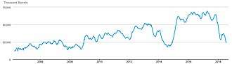
The crude oil tanks around Cushing have approximately 91 million barrels of storage capacity.[23][24][25] On October 28, 2016, tanks held a total of 58.5 million barrels of oil,[26] though it has dropped in 2018.[27]
A partial list of tank farm owners at Cushing are:[28]
- Magellan Midstream Partners, 7,800,000 barrels (1,240,000 m3) of storage, formerly owned by BP.
- Enbridge Energy Partners, 20,060,000 barrels (3,189,000 m3) of storage.
- Enterprise Products, 3,100,000 barrels (490,000 m3) of storage.
- JP Energy, 3,000,000 barrels (480,000 m3) of storage.
- Plains All American Pipeline, 20,000,000 barrels (3,200,000 m3) of storage.
- SemGroup, 7,600,000 barrels (1,210,000 m3) of storage at Rose Rock Midstream Cushing terminal.
Pipelines with connections at Cushing include:[29]
- Basin Oil Pipeline, operated by Plains All American Pipeline, flows from Wichita Falls, Texas connecting various fields in Texas.
- Centurion Pipeline, flows from Permian Basin fields in west Texas and southeast New Mexico.
- Hawthorn Pipeline, operated by Hawthorn Oil Transportation, a 17-mile pipeline from Stroud, Oklahoma where a rail unloading facility receives oil from Stanley, North Dakota for EOG Resources.[30][31][32]
- Glass Mountain Pipeline, operated by Rose Rock Midstream (SemGroup), flows from fields in west and north-central Oklahoma.
- Great Salt Plains Pipeline, operated by JP Energy, flows from fields around Cherokee, Oklahoma, formerly owned by Parnon Gathering.[33][34]
- Keystone Pipeline, operated by TransCanada, flows from Hardisty, Alberta (Canada) to an intermediary hub in Cushing to Port Arthur, Texas. It has a maximum capacity of 590,000 barrels per day (94,000 m3/d). Another Keystone termination is located at the oil tank farm near Patoka, Illinois.[35][36]
- Mississippian Lime Pipeline, operated by Plains All American Pipeline, flows from fields in northern Oklahoma and southern Kansas.
- PAA Medford Pipeline, operated by Plains All American Pipeline, from fields around Medford, Oklahoma.
- Pony Express Pipeline, operated by Tallgrass Energy Partners, flows from fields around Guernsey, Wyoming. It connects to the Ponca City Refinery. It has a capacity of 230,000 barrels per day (37,000 m3/d) and capable of increasing to 400,000 barrels per day (64,000 m3/d).
- Seaway Pipeline, a dual pipeline operated by Enbridge and Enterprise Products, flows out to Freeport, Texas. It has a maximum capacity of 850,000 barrels per day (135,000 m3/d).
- SemCrude Pipeline System, operated by Rose Rock Midstream (SemGroup), flows from fields in Kansas and northern Oklahoma.
- Spearhead Pipelines, operated by Enbridge, is a pipeline that flows from the Enbridge Mainline System near Flanagan, Illinois. It has a maximum capacity of 125,000 barrels per day (19,900 m3/d).[37] A second pipeline, Flanagan South, parallels the Spearhead. A third Enbridge pipeline connects to the Wood River Refinery in Roxana, Illinois.[38]
- White Cliffs Pipeline, operated by Rose Rock Midstream, flows from fields around Platteville, Colorado.
Transhipment point for West Texas Intermediate (WTI) oil
Cushing is the delivery point for West Texas Intermediate, a blend of US light sweet crude oil streams[21] traded on the New York Mercantile Exchange[39]
Cushing's strategic position as a major hub in oil supply led to WTI's development as a significant physical market price reference or benchmark for over three decades.
In 2005 Cushing was described as the most significant trading hub for crude oil in North America, connecting the Gulf Coast suppliers with northern consumers.[40]
By 2007 Cushing held 5% to 10% of the total US crude inventory. Signs made of a pipe and valve on the major highways near town proclaim Cushing to be the "Pipeline Crossroads of the World", and the town is surrounded by several tank farms.
Oil futures designated delivery point in the US
On April 13, 2007, the now-defunct Lehman Brothers released a study which claimed that West Texas Intermediate (WTI) crude at Cushing is no longer an accurate gauge of world oil prices.[41] By May 2007, Cushing's inventory fell by nearly 35% as the oil-storage trade heated up.[42]
Oil giant BP, and energy-transport and logistics firms Enbridge Energy Partners (an affiliate of Canada's Enbridge), Plains All American Pipeline and SemGroup owned most of the oil storage tanks in Cushing in October 2007.[42]
Oil storage became big business in 2008 and 2009, when the supply glut in the oil market led to situation where oil futures were higher priced than their spot price.[43] Many participants—including Wall Street giants, such as Morgan Stanley, Goldman Sachs, and Citicorp—turned sizeable profits simply by sitting on tanks of oil.[42] Institutional investors bet on the future of oil prices through a financial instrument known as oil futures, in which investors contractually agree to buy or sell oil at a set date in the future. Investors can choose to take profits or losses prior to the oil-delivery date. Alternatively, they can leave the contract in place and take physical delivery of the oil at an "officially designated delivery point" in the United States; this delivery point is usually Cushing.
On July 13, 2010, BP announced it will sell its assets in Cushing to Magellan Midstream Partners.[44]
In April 2020, it was lack of storage capacity at Cushing which turned WTI petroleum futures contracts negative for the first time in history.[45][46] While Cushing has maximum storage of about 90 million barrels across 15 terminals, working storage is more like 76 million barrels, about 13% of total U.S. oil storage capacity.[47] With 59.5 million barrels stored, little demand for oil from customers, and much of the remainder of the storage capacity already booked, traders holding contracts for hundreds of thousands of barrels of oil for delivery at Cushing on April 21 realized they had no place to put the oil, and storage fees charged under the contracts for not taking the oil could be astronomical.[46][47] Thus paying a party having already-contracted storage capacity to take the oil was cheaper than incurring those contractual storage fees.[47]
Cushing storage hub bottleneck
The bottleneck at Cushing's giant storage hub distorted benchmark US oil prices for many years. In 2007 a large stockpile of oil at the facility was caused largely because Valero Energy Corp.'s McKee refinery near Sunray, Texas, was temporarily shut down.[48] With the refinery closed, crude oil prices were artificially depressed at the Cushing pricing point. The Eagle North pipeline reactivated in 2010, added offtake capacity to Cushing by connecting Valero's oil refinery in Ardmore, Oklahoma with Cushing's cheap crude oil. This should have resulted in boosting WTI prices which were discounted against Brent crude oil because of the glut.[49]
In March 2013 Valero Energy Corp.'s (VLO) McKee refinery in Sunray, Texas was closed for five weeks for planned maintenance.[50]
Oil industry and seismic activity
In October 2014 two moderate-sized earthquakes (Mw 4.0 and 4.3) struck south of Cushing, below one of the largest crude oil storage facility and gas pipeline transportation hubs in the world. The system also includes operational sections of the Keystone pipeline.[51]
On 6 November 2016, around 7:44 pm, a 5.0 MW earthquake rattled north-central Oklahoma. The quake was centered one mile west of Cushing.[26] It was the sixth 5.0 magnitude or higher to strike the state since 1882. Three of those larger quakes occurred in 2016, and the strongest ever recorded in Oklahoma was a 5.8 magnitude that hit Pawnee (25 miles from Cushing) in September.[52]
According to George Choy, a geophysicist with the U.S. Geological Survey, Oklahoma has had a severe spike in earthquakes of 3.0 magnitude or higher since 2008. The number of 3.0 magnitude quakes rose from 2 in 2008 to 889 in 2015, according to USGS statistics. In 2016, there have been 572 (up to November). "The oil companies have said for a long time that these are natural earthquakes, that they would have occurred anyway," Choy said, "but when you look at the statistics, that argument does not fly."[52]
Analysis of the spatial distribution of earthquakes and regional moment tensor focal mechanisms indicated reactivation of a subsurface unmapped strike-slip fault.[51] The discovery stoked fears among scientists about other unknown faults that could be triggered by oil and gas wastewater being injected deep underground.[53] Coulomb failure stress change calculations indicated that the Wilzetta Fault zone south of Cushing could produce a large, damaging earthquake comparable to the 2011 Oklahoma earthquake at Prague, Oklahoma.[51]
Much of the production, using new horizontal drilling techniques, produces at very high rates, with very high water-to-oil ratios. Thus many of the disposal wells, which re-inject the brine into underground formations, handle much more water at much higher pressures than has been common in other, often older, plays. When high volume, high pressure liquids follow the planes in some susceptible dormant faults, it frequently causes them to slip resulting in quakes. After the strongest earthquake in Oklahoma's history, at Pawnee, recorded at 5.8 on the Moment magnitude scale, concerns about the relationship between disposal wells and earthquakes caused state and federal regulators to respond by shutting down more than 50 disposal sites and wells across the state, considering their proximity to fault lines.[52][53]
Notable people
- Paul Blair, professional baseball player[54]
- Al Buell, former painter of pin-up art
- Kelly Cook, former running back in the National Football League[55]
- Chief Hogsett, former pitcher in Major League Baseball. Played for 1925 Cushing Refiners
- Brian Kelly, professional boxer
- Bob Shirley, former professional baseball pitcher
References
- "2018 U.S. Gazetteer Files". United States Census Bureau. Retrieved February 12, 2020.
- "Population and Housing Unit Estimates". Retrieved June 4, 2019.
- "U.S. Census website". United States Census Bureau. Retrieved January 31, 2008.
- "US Board on Geographic Names". United States Geological Survey. October 25, 2007. Retrieved January 31, 2008.
- "Cushing, OK Population - Census 2010 and 2000 Interactive Map, Demographics, Statistics, Quick Facts - CensusViewer". censusviewer.com.
- Encyclopedia of Oklahoma History and Culture."Cushing". By D. Earl Newsome, Accessed June 9, 2010.
- "NYMEX WTI Crude Oil Futures & Options". www.cmegroup.com.
- Oklahoma Oil History. American Oil & Gas Historical Society
- "US Gazetteer files: 2010, 2000, and 1990". United States Census Bureau. February 12, 2011. Retrieved April 23, 2011.
- "Historical Weather for Cushing, Oklahoma, United States".
- Cushing School District, Education.com (accessed June 9, 2010).
- "Memorial Park - Cushing, OK". Waymarking.com. Retrieved June 1, 2020.
- "Aquatic Center". City of Cushing. Retrieved June 1, 2020.
- "Downtown Cushing Centennial Park". TravelOK.com. Retrieved June 1, 2020.
- "Buffalo Rock Golf and Venue Golf Course". Golflink.com. Retrieved June 1, 2020.
- "Cushing Lake". TravelOK.com. Retrieved June 3, 2020.
- "Cushing, OK - BR Bullpen". www.baseball-reference.com.
- "Carl Hubbell | Society for American Baseball Research". sabr.org.
- "Cushing, Oklahoma". Google Maps. Retrieved June 3, 2020.
- "Cushing Municipal Airport". AirNav.com. Retrieved June 3, 2020.
- "Light Sweet Crude Oil (WTI) Futures and Options: When the World Asks, "What's the Price of Crude Oil?" WTI is the Answer" (PDF). CME Group. Archived from the original (PDF) on May 20, 2013. Retrieved April 15, 2013.
- Smoot, D.E. (August 28, 2016). "Company prepares to construct pipeline through Muskogee, McIntosh counties". Muskogee Phoenix. Retrieved August 28, 2016.
- Oil tanker demand booms as traders wait out cheap oil; cbc.ca; January 14, 2015.
- "US running out of room to store oil; price collapse next? - Yahoo News". web.archive.org. March 3, 2015.
- "EIA - Working and Net Available Shell Storage Capacity, September 2019" (PDF).
- "Extensive damage reported from Oklahoma earthquake near major oil hub". www.cbsnews.com.
- "USA — Weekly". Oil Sands Magazine.
- Upton, Luke (January 30, 2014). "Inside the World's Biggest Tank Farm – Cushing, Oklahoma, USA".
- "U.S. Crude Oil Pipeline Project". Yahoo Finance. April 6, 2015.
- "Company history; EOG Resources".
- First train with EOG Resources Bakken crude oil departs Stanley, ND for Oklahoma Archived 2016-11-09 at the Wayback Machine; EOG Resources. North Dakota Petroleum Council, December 31, 2009.
- Crude Oil Offload Terminal; JFSCO Engineering. Archived 2015-04-02 at the Wayback Machine
- "Great Salt Plains Pipeline; IPS Engineering". Archived from the original on March 10, 2014.
- "JP Energy Partners Acquires Parnon Storage and Parnon Gathering". www.businesswire.com. August 14, 2012.
- Newton, Ken (June 9, 2010). "Oil Flows Through Keystone". St. Joseph, Missouri: St. Joseph News-Press.
- "Press Release – Keystone Pipeline Starts Deliveries to U.S. Midwest; TransCanada; June 30, 2010". Archived from the original on November 24, 2014. Retrieved March 2, 2015.
- "Liquids Pipelines". Enbridge. Retrieved February 8, 2012.
- EIA Short-Term Look At Crude Oil Pipeline Infrastructure; Pipeline & Gas Journal; April 2013. Archived 2015-04-02 at the Wayback Machine
- U.S. Energy Information Administration (EIA). "Upcoming Pipeline Capacity Additions Will Facilitate Continued Growth in Crude Oil Shipments from Midwest to Gulf Coast" (PDF). This Week in Petroleum. CME Group.
- The 2005 Oklahoma Refinery Report: Appendix A (PDF) (Report). Oklahoma: Office of the Secretary of Energy. April 2005. Archived from the original (PDF) on October 15, 2008.
- Habiby, Margot (April 13, 2007). "WTI Prices Don't Reflect International Oil Market, Study Says". Bloomberg.
- Davis, Anne (October 6, 2007). "Where Has All The Oil Gone? After Sitting on Crude, Speculators Unload It. The World's Eyes Fall on Cushing, Oklahoma". Wall Street Journal.
- Norris, Michele (December 17, 2008). "Contango In Oil Markets Explained".
- "Magellan snaps up BP midstream package". Upstream Online. NHST Media Group. July 13, 2010. Retrieved July 13, 2010.
- "No vacancy: Main U.S. oil storage in Cushing is all booked". Laila Kearney & Devika Krishna Kumar, Reuters News Agency, April 21, 2020. Retrieved May 3, 2020.
- "Oil Turns Red". Cushing Citizen, April 22, 2020. Retrieved May 3, 2020.
- Slav, Irina. "The Most Critical Oil Storage In The United States". OilPrice.com, May 2, 2020. Archived from the original on May 4, 2020. Retrieved May 3, 2020.
- Mark Shenk (April 13, 2007). "Crude Oil in New York Falls on Increasing Supplies in Oklahoma". Bloomberg.
- Campbell, Robert (October 5, 2010). "Valero oil refinery to link to Cushing hub soon". Reuters. New York.
- "Refinery Status: Citgo Reports Leak at Corpus Christi". Wall Street Journal. April 4, 2013.
- McNamara, D. E. et al. (2015),Reactivated faulting near Cushing, Oklahoma: Increased potential for a triggered earthquake in an area of United States strategic infrastructure, Geophysical Research Letters, 42, 8328–8332, doi:10.1002/2015GL064669.
- Oklahoma earthquake reignites concerns that fracking wells may be the cause. By Rick Jervis. USA TODAY, November 7, 2016.
- New fault line discovered after 5.8 Oklahoma earthquake,The Wichita Eagle, Sean Murphy Associated Press, September 13, 2016. Retrieved 23 May 2017.
- News services and staff reports (December 28, 2013) "Star center fielder won two titles with Orioles" The Washington Post, page B4. Retrieved December 28, 2013
- "Kelly Cook". databaseFootball.com. Archived from the original on November 4, 2012. Retrieved December 15, 2012.
External links
| Wikimedia Commons has media related to Cushing, Oklahoma. |
- Official website

- Cushing Chamber of Commerce
- Cushing Citizen
- Cushing Citizen Online (archived)
- Encyclopedia of Oklahoma History and Culture - "Cushing"
- Cushing Public Schools
- Cushing in 2009, ABC TV
- Weekly Cushing, OK Ending Stocks (crude oil), U.S. Energy Information Administration. Graph of last 2 years
Municipalities and communities of Payne County, Oklahoma, United States | ||
|---|---|---|
| Cities | 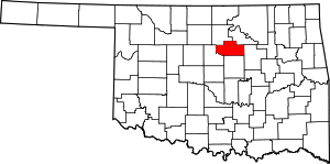 Map of Oklahoma highlighting Payne County | |
| Towns | ||
| Unincorporated communities | ||
| Ghost town | ||
| Footnotes | ‡This populated place also has portions in an adjacent county or counties | |
| Authority control |
|
|---|