Muzaffarpur
Muzaffarpur (![]()
Muzaffarpur | |
|---|---|
City | |
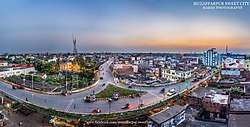 Muzaffarpur Skyline near Motijhil Flyover | |
 Muzaffarpur  Muzaffarpur  Muzaffarpur | |
| Coordinates: 26°7′21″N 85°23′26″E | |
| Country | |
| State | Bihar |
| Region | Tirhut |
| District | Muzaffarpur district |
| Established | 1875 |
| Municipal Corporation | Muzaffarpur Municipal Corporation |
| Government | |
| • Member of Parliament | Ajay Nishad |
| • Member of Legislative Council | Dinesh Prasad Singh |
| • Member of Legislative Assembly | Suresh Sharma |
| • Mayor | Suresh Kumar |
| Area | |
| • Total | 93 km2 (36 sq mi) |
| Elevation | 60 m (200 ft) |
| Population | |
| • Total | 393,724[1] |
| • Rank | 4th (Bihar) 127th (India) |
| Time zone | UTC+5:30 (IST) |
| PIN | 842001-05 |
| Telephone code | 0621 |
| Vehicle registration | BR-06 |
| Sex ratio | 890 (females per thousand males)[2]♂/♀ |
| Literacy | 85.16%[2] |
| Lok Sabha constituency | Muzaffarpur |
| Vidhan Sabha constituency | Muzaffarpur |
| Website | muzaffarpur |
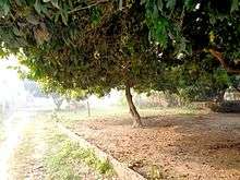
Muzaffarpur is famous for Shahi lychees and is known as the Lychee Kingdom.[3][4] Shahi litchi is set to become the fourth product from Bihar, after jardalu mango, katarni rice and Magahi paan (betel leaf) to get the Geographical Indication (GI) tag. It is situated on the banks of the perennial Burhi Gandak River, which flows from the Someshwar Hills[5] of the Himalayas.
History
Muzaffarpur's significance in Indian civilisation is due to its position between cultural and spiritual influences, and is a melting pot of Hindu and Islamic culture. Muzaffarpur has had prominent Indian political leaders, such as Rajendra Prasad, George Fernandes and J. B. Kripalani. The vernacular languages of the region are Maithili and Bajjika, as per the linguist George Grierson;,[6] derived from the language of the Vedic Vrijji confederation.
Etymology
The current city was established in 1875 during the British Raj for administrative convenience, by dividing the Tirhut district and was named after an aumil, Muzaffar Khan; thus the city came to be known as Muzaffarpur.[7]
Geography
Muzaffarpur is located at 26°07′N 85°24′E.[9] The city lies in a highly active seismic zone of India. In the disastrous earthquake on 15 January 1934, much of the town suffered severe damage and many lives were lost.[10] It has an average elevation of 47 meters (154 feet). This saucer shaped, low-centered town lies on the great Indo-Gangetic plains of Bihar, over Himalayan silt and sand brought by the glacier-fed and rain-fed meandering rivers of the Himalayas.
Climate
Muzaffarpur has humid subtropical climate (Cfa) under Köppen climate classification. The summer, between April and June, is extremely hot and humid (28/40 °C, 90% max.) and winter is pleasantly cool, around 06/20 °C. Rainfall in Muzaffarpur Town is comparatively less to the other parts of Bihar.
| Climate data for Muzaffarpur | |||||||||||||
|---|---|---|---|---|---|---|---|---|---|---|---|---|---|
| Month | Jan | Feb | Mar | Apr | May | Jun | Jul | Aug | Sep | Oct | Nov | Dec | Year |
| Record high °C (°F) | 29 (84) |
39 (102) |
40 (104) |
43 (109) |
48 (118) |
46 (115) |
52 (126) |
40 (104) |
39 (102) |
44 (111) |
39 (102) |
29 (84) |
52 (126) |
| Average high °C (°F) | 22 (72) |
26 (79) |
32 (90) |
37 (99) |
44 (111) |
40 (104) |
36 (97) |
33 (91) |
32 (90) |
32 (90) |
29 (84) |
24 (75) |
32 (90) |
| Daily mean °C (°F) | 18.5 (65.3) |
20.8 (69.4) |
25.0 (77.0) |
27.7 (81.9) |
27.9 (82.2) |
28.0 (82.4) |
28.4 (83.1) |
28.4 (83.1) |
28.4 (83.1) |
27.0 (80.6) |
23.4 (74.1) |
19.8 (67.6) |
25.3 (77.5) |
| Average low °C (°F) | 06 (43) |
12 (54) |
17 (63) |
22 (72) |
25 (77) |
27 (81) |
26 (79) |
26 (79) |
26 (79) |
22 (72) |
15 (59) |
07 (45) |
19 (67) |
| Record low °C (°F) | 1 (34) |
5 (41) |
10 (50) |
15 (59) |
16 (61) |
16 (61) |
22 (72) |
18 (64) |
21 (70) |
9 (48) |
8 (46) |
4 (39) |
1 (34) |
| Average precipitation mm (inches) | 12 (0.5) |
17 (0.7) |
7 (0.3) |
16 (0.6) |
42 (1.7) |
185 (7.3) |
339 (13.3) |
259 (10.2) |
242 (9.5) |
39 (1.5) |
17 (0.7) |
7 (0.3) |
1,182 (46.6) |
| Source: Muzaffarpur Weather | |||||||||||||
Economy
In 2006 the Ministry of Panchayati Raj named Muzaffarpur one of the country's 250 most backward districts (out of a total of 640).[11] It is one of the 36 districts in Bihar currently receiving funds from the Backward Regions Grant Fund Programme (BRGF).[11]
Lychee
The lychee crop, which is available from May to June, is mainly cultivated in the districts of Muzaffarpur and surrounding districts. Cultivation of litchi covers approximately an area of about 25,800 hectares producing about 300,000 tonnes every year. Litchi are exported to big cities of India like Bombay, Kolkata, and even to other countries. India's share in the world litchi market amounts to less than 1%. The names of the litchi produced in Muzaffarpur are Shahi and China. The fruits are known for excellent aroma and quality.[12]
Bihar's contribution in the production of lychee in about 40 percent of lychee produced in India.[13]
Bihar has emerged as a brewery hub with major domestic and foreign firms setting up production units in the state. Vijay Mallya's group, United Breweries Group, is setting up a production unit to make litchi-flavoured wine, in Muzaffarpur in 2012. The company has leased litchi gardens.[14]
Muzaffarpur based Prabhat Zarda Factory is one of the leading tobacco manufacturers of India.[15]
Demographics
As of the 2011 India census,[16]
As by 2011 Census data there are total 275,233 Hindus whereas 74,680 Muslims and 1,352 Christians alongwith other small minorities.[17]
Muzaffarpur had a population of 393,724.[1] Males constituted 52.96% (208,509) of the population and females 47.04% (185,215).[1] Muzaffarpur had a literacy rate of 74.74%. Male literacy was 77.99%, and female literacy was 71.08%.[1]
Transport
Railways
Muzaffarpur Junction railway station is a main railway junction, with two suburban stations, Ram Dayalu Nagar and Narayanpur Anant (Sherpur). It is well connected to major cities of Bihar like Patna, Bhagalpur, Gaya, Chakia , motihari and Darbhanga. It also connects Muzaffarpur to many metropolitan cities in India like Delhi, Mumbai, and Kolkata.
Roads
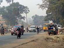
National Highway 57 (India) comes via Gorakhpur, Motihari, Chakia and crosses Muzaffarpur and National Highway 57 (India) goes to Darbhanga, Purnia. The East–West Corridor crosses Muzaffarpur thus connecting it to all the major towns and cities in India. National Highway 77 (India) starting from Hajipur passes through Muzaffarpur and connects Muzaffarpur to Sitamarhi. National Highway 28 (India) connects Muzaffarpur to Barauni, all 6 National Highways having junction there.
Notable people
- Yogendra Shukla revolutionary, Indian freedom movement activist, served time at Kalapani
- Basawon Singh (Sinha) revolutionary, Indian freedom movement activist
- Baikunth Shukla revolutionary hanged by the British in 1934
- Siddhant Sarang, Indian Climate Activist[18]
- Rambriksh Benipuri Indian freedom movement activist, eminent writer of Hindi literature
- Kishori Sinha Indian politician and educationalist
- Maghfoor Ahmad Ajazi, political activist
- Janki Ballabh Shastri, Hindi poet, writer and critic
- Chandeshwar Prasad Narayan Singh, diplomat and freedom fighter
- Shatrughan Sahu, Politician
- Rajendra Prasad, India's first president, worked as a professor of English in Langat Singh College
- Richa Soni, TV actress
- Devaki Nandan Khatri, the author of Chandrakanta (in Hindi)
- Jubba Sahni, freedom fighter
- Mridula Sinha, Governor of Goa (2014–present)
- Veena Devi, Indian politician, Member of 17th Lok Sabha
- Dinesh Prasad Singh, Indian politician
- Aishwarya Nigam, a Bollywood playback singer
- Shahbaz Nadeem, Indian cricketer
- Sudhir Kumar Chaudhary, sports spectator and fan of the Indian Cricket Team
- Shreya Narayan, Bollywood actress
- Arunabh Kumar, Founder and ex-CEO of TVF
- Subrat Saurabh, a writer
See also
- Appan Samachar
- Baba Garib Sthan Mandir
- Muzaffarpur district
- List of cities in Bihar
- Sujini embroidery work of Bihar
References
- "Urban Agglomerations/Cities having population 1 lakh and above" (PDF). Provisional Population Totals, Census of India 2011. Government of India. Archived (PDF) from the original on 13 November 2011. Retrieved 16 April 2012.
- "Cities having population 1 lakh and above" (PDF). Provisional Population Totals, Census of India 2011. Government of India. Archived (PDF) from the original on 7 May 2012. Retrieved 16 April 2012.
- "Bihar's famous Shahi litchi to get GI tag soon".
- Destinations :: Vaishali ::Bihar State Tourism Development Corporation Archived 22 July 2015 at the Wayback Machine. Bstdc.bih.nic.in. Retrieved on 9 January 2011.
- "bihar". Scribd.com. Archived from the original on 8 November 2012. Retrieved 2 August 2014.
- Abhishek Kumar Kashyap, "The Bajjika language and speech community Archived 19 February 2017 at the Wayback Machine" in International Journal of the Sociology of Language 227:209-224, May 2014. DOI: 10.1515/ijsl-2014-0001. Accessed 18 February 2017
- Faizi, Amir Afaque Ahmad (2009). Self-help Groups and Marginalised Communities. Concept Publishing Company. p. 6. ISBN 978-81-8069-621-3. Retrieved 20 January 2020.
- Law, Gwillim (25 September 2011). "Districts of India". Statoids. Archived from the original on 17 October 2011. Retrieved 11 October 2011.
- Falling Rain Genomics, Inc – Muzaffarpur Archived 21 March 2008 at the Wayback Machine
- Bihar India Earthquake Movie, 15 January 1934 Archived 6 January 2009 at the Wayback Machine. Harappa.com (15 January 1934). Retrieved on 9 January 2011.
- Ministry of Panchayati Raj (8 September 2009). "A Note on the Backward Regions Grant Fund Programme" (PDF). National Institute of Rural Development. Archived from the original (PDF) on 5 April 2012. Retrieved 27 September 2011.
- "7. LYCHEE PRODUCTION IN INDIA". Fao.org. 31 May 1992. Archived from the original on 17 November 2014. Retrieved 2 August 2014.
- "Bihar is the top litchi producing State, about 300 thousand metric tonnes of litchi is being produced from 32 thousand hectare areas: Shri Radha Mohan Singh". pib.nic.in.
- "Bihar emerging as brewery hub". Economic Times. 16 January 2012. Archived from the original on 24 May 2014. Retrieved 16 January 2012.
- Sinha, Nishant (20 July 2016). "Sale of tobacco products legal". www.telegraphindia.com. Retrieved 17 January 2020.
- "Census of India 2001: Data from the 2001 Census, including cities, villages and towns (Provisional)". Census Commission of India. Archived from the original on 16 June 2004. Retrieved 1 November 2008.
- "Muzaffarpur District Population, Bihar, List of Taluks in Muzaffarpur".
- "Siddhant Sarang a Climate Activist from India (Exclusive Conversation)". EMEA Tribune News | Pakistan News | India News | Europe News | World News. 16 June 2020. Retrieved 17 June 2020.
External links
| Wikimedia Commons has media related to Muzaffarpur. |
- Official website of Muzaffarpur District
- Official website of Tirhut Division
- . Encyclopædia Britannica (11th ed.). 1911.
| State symbols | |
|---|---|
| History |
|
| Administration |
|
| Overviews | |
| Divisions and districts | |
| Cities | |
| Municipal Corporation |
|
| Poltics | |
| Culture |
|