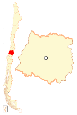
Curicó
Curicó (Spanish pronunciation: [kuri'ko]), meaning "Black Waters" in Mapudungun (originally meaning "Land of Black Water"), is the capital city of the Curicó Province, part of the Maule Region in Chile's central valley.
Curicó | |
|---|---|
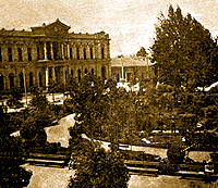
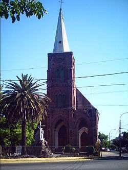 San Francisco Church before 2010 | |
 Flag  Coat of arms 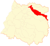 Map of Curicó commune in the Maule Region 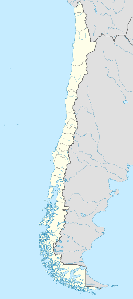 Curicó Location in Chile | |
| Motto(s): " Noble y Leal Villa de San José de Buena Vista de Curicó" Noble and Loyal Villa of San José de Buena Vista from Curicó | |
| Coordinates (city): 34°59′S 71°14′W | |
| Country | Chile |
| Region | Maule |
| Province | Curicó |
| San José de Buena Vista de Curicó | October 9, 1743 |
| Government | |
| • Type | Municipality |
| • Alcalde | Javier Muñoz |
| Area | |
| • Total | 1,328.4 km2 (512.9 sq mi) |
| Elevation | 228 m (748 ft) |
| Population (2012 Census)[2] | |
| • Total | 136,954 |
| • Density | 100/km2 (270/sq mi) |
| • Urban | 100,506 |
| • Rural | 19,079 |
| Demonym(s) | Curican |
| Sex | |
| • Men | 58,768 |
| • Women | 70,817 |
| Time zone | UTC-4 (CLT [3]) |
| • Summer (DST) | UTC-3 (CLST [4]) |
| Postal code | 3349001 |
| Area code(s) | 56 + 75 |
| Climate | Csb |
| Website | Official website (in Spanish) |
The province lies between the provinces of Colchagua and Talca and extends from the Pacific to the Argentine frontier.
Demographics
According to the 2012 census of the National Statistics Institute, Curicó spans an area of 1,328.4 km2 (513 sq mi) and has 147,017 inhabitants (68,768 men and 70,817 women). Of these, 130,506 (84%) lived in urban areas and 19,079 (16%) in rural areas. Between the 1992 and 2002 censuses, the population grew by 14.9% (15,472 persons).[2]
Geography
Curicó is on the Guaiquillo River, 183 km (114 mi) south of Santiago along the route of the Chilean Central Railway. The city is situated in the fertile Chilean Central Valley, 228 m (748 ft) above sea-level, in the midst of a comparatively well-cultivated region. The eastern and western sides are mountainous, separated by the Chilean Central Valley. The commune spans an area of1,328.4 km2 (513 sq mi).[2]
Mineral resources are undeveloped, but are said to include copper, gold and silver. Cattle, wheat and wine are the principal products, but Indian corn and fruit also are produced. On the coast are important salt-producing industries.
The main rivers are the Lontué River and Teno River, which surround the city. The landscape is dominated by the Andes and Chilean Coastal Range.
Climate
Curicó has a warm-summer Mediterranean climate (Köppen climate classification Csb), relatively hot dry summers (November to March) with temperatures reaching 32 °C (90 °F) on the hottest days. Winters (June to August) are more humid, with typical maximum daily temperatures of 15 °C (59 °F). Mean rainfall is 855.98 mm (34 in) per year. In August 2007, Curicó experienced snowfall for the first time in over 60 years.
In the southern part of the valley the climate is more temperate and rainfall more abundant; the effects of this are to be seen in better pasturage. Irrigation is used to a large extent.
| Climate data for Curicó (General Freire Airfield) 1981–2010, extremes 1952–present | |||||||||||||
|---|---|---|---|---|---|---|---|---|---|---|---|---|---|
| Month | Jan | Feb | Mar | Apr | May | Jun | Jul | Aug | Sep | Oct | Nov | Dec | Year |
| Record high °C (°F) | 37.3 (99.1) |
37.4 (99.3) |
35.2 (95.4) |
31.2 (88.2) |
27.5 (81.5) |
21.4 (70.5) |
22.8 (73.0) |
25.9 (78.6) |
29.4 (84.9) |
31.6 (88.9) |
35.6 (96.1) |
35.0 (95.0) |
37.4 (99.3) |
| Average high °C (°F) | 29.8 (85.6) |
29.1 (84.4) |
26.1 (79.0) |
20.7 (69.3) |
15.4 (59.7) |
12.5 (54.5) |
12.2 (54.0) |
14.5 (58.1) |
17.5 (63.5) |
21.0 (69.8) |
24.9 (76.8) |
28.0 (82.4) |
21.0 (69.8) |
| Daily mean °C (°F) | 21.0 (69.8) |
20.3 (68.5) |
18.0 (64.4) |
13.8 (56.8) |
10.4 (50.7) |
8.6 (47.5) |
7.9 (46.2) |
9.4 (48.9) |
11.5 (52.7) |
14.3 (57.7) |
17.1 (62.8) |
19.7 (67.5) |
14.3 (57.7) |
| Average low °C (°F) | 13.3 (55.9) |
12.8 (55.0) |
11.4 (52.5) |
8.6 (47.5) |
6.3 (43.3) |
4.8 (40.6) |
3.7 (38.7) |
4.7 (40.5) |
6.3 (43.3) |
8.2 (46.8) |
10.2 (50.4) |
12.3 (54.1) |
8.5 (47.3) |
| Record low °C (°F) | 3.2 (37.8) |
2.2 (36.0) |
−2.0 (28.4) |
−6.0 (21.2) |
−5.0 (23.0) |
−6.1 (21.0) |
−6.8 (19.8) |
−6.6 (20.1) |
−3.2 (26.2) |
−4.2 (24.4) |
−1.2 (29.8) |
0.9 (33.6) |
−6.8 (19.8) |
| Average precipitation mm (inches) | 2.6 (0.10) |
3.4 (0.13) |
12.8 (0.50) |
31.3 (1.23) |
118.0 (4.65) |
163.7 (6.44) |
129.8 (5.11) |
99.0 (3.90) |
55.5 (2.19) |
26.0 (1.02) |
11.2 (0.44) |
4.8 (0.19) |
658.1 (25.91) |
| Average precipitation days | 0.6 | 0.5 | 1.4 | 4.2 | 9.4 | 11.9 | 10.5 | 8.3 | 6.4 | 4.6 | 2.1 | 1.1 | 61.0 |
| Average relative humidity (%) | 51 | 54 | 60 | 71 | 81 | 86 | 84 | 79 | 73 | 66 | 58 | 53 | 68 |
| Mean monthly sunshine hours | 355 | 299 | 250 | 167 | 98 | 69 | 87 | 126 | 159 | 219 | 272 | 316 | 2,417 |
| Source 1: Dirección Meteorológica de Chile (precipitation days and humidity 1970–2000)[5][6][7] | |||||||||||||
| Source 2: Ogimet (sun 1981–2010)[8] | |||||||||||||
History
Curicó was founded in 1743 by Jose Manso de Velasco during the Spanish reign in the Americas (see Captaincy General of Chile). It is one of the more cultured and progressive provincial towns of Chile.
In 1747, Governor Domingo Ortiz de Rozas decided to move it about 5 km (3 mi) to the north, where it is now located, because of the humidity in its original location.
The oldest and most valuable building of the city is La Iglesia San Francisco (San Francisco's Church), built in 1734, and came to its current location in 1759.
Curicó gained the title of "city" in 1830.
The city's hero is Luis Cruz Martínez, a Chilean soldier from the War of the Pacific, who died in 1882 in Perú.
The city was destroyed by an earthquake in 1928 and rebuilt during the following year.
The city was badly damaged in the February 2010 earthquake. An Argentine Air Force Mobile Field Hospital, similar to the one deployed in Haiti was deployed to the city [9] and remained on site until September [10]
Economy
The city's economy is based mainly on agriculture. The Mediterranean-type climate encourages crops of orchard fruit and viticulture.
Other industries are cement and sugar production.
In human development the city had 0.716 (UNDP, Chile 2000), reaching the 97th position in the municipalities of Chile .
Tourism and Society
| population trend | |
|---|---|
| year | inhabitants |
| 1895 | 12,669 |
| 1952 | 28,618 |
| 1960 | 34,646 |
| 1970 | 43,524 |
| 1982 | 63,658 |
| 1992 | 77,733 |
| 2002 | 119,585 |
| 2005 | 120,113 |
Between March 15 and 20 each year, the city celebrates a wine celebration: the Fiesta de la Vendimia (Wine Harvest Festival). The region has a La Ruta del Vino (The Wine Route), in Curicó Valley. It is also known as "the city of cakes" (made from manjar, meringue and fruit).
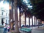
The Plaza de Armas (Main Square) is the most visited public place (declared a "Typical Zone"). There is a monument to Lautaro carved on the trunk of a beech tree, created by the craftsman of Vichuquén, Heraclio "Kako" Calquín. Located around Plaza de Armas are the mayor's house (alcaldía) and the governor's house.
A few blocks from the plaza, the Alameda Antonio Manso de Velasco avenue crosses the city with its gardens and leafy trees. There is also the Condell hill, a place which offers a panoramic view of the city and the San Francisco church.
Potrero Grande is a mountainous area with large forests and waterfalls, popular for hiking, located about 30 km (19 mi) from Curicó.
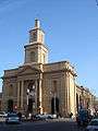 The main parish church around main square.
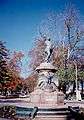 Luis Cruz Martínez, hero from Curicó.
- San Francisco Church, before being destroyed in the 2010 earthquake
 Curicó, Alameda, 2012
 Cerro Condell, Curicó
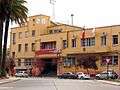 Correos de Chile (Post office) and Curicó's Municipalidad (City hall)
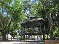 Kiosk in Curicó's Plaza de Armas
Education
The city has two universities:
Higher-education institutions:
- Instituto Profesional DuocUC of the Pontificia Universidad Católica de Chile
- Instituto Profesional AIEP of the Universidad Andrés Bello
Media
The city has one of the oldest newspapers in Chile, La Prensa de Curicó (Press of Curico), founded in 1898.[11] Before the earthquake of 2010, its offices were located in front of the central square, but have been relocated since because the building collapsed.
 Victoria Theatre
 Diario La Prensa
Sports
Curicó is known for its bicycle culture. Many Chilean cyclists of international level started riding in the city, such as Marco Arriagada, Marcelo Arriagada and Luis Fernando Sepúlveda.
The local football team is Club Provincial Curicó Unido.
Administration
As a commune, Curicó is a third-level administrative division of Chile administered by a municipal council, headed by an alcalde who is directly elected every four years. Currently, the 2012-2016 alcalde is Javier Muñoz Riquelme.[1]
Within the electoral divisions of Chile, Curicó is represented in the Chamber of Deputies by Mr. Roberto León (PDC) and Mr. Celso Morales (UDI) as part of the 36th electoral district, (together with Teno, Romeral, Molina, Sagrada Familia, Hualañé, Licantén, Vichuquén and Rauco). The commune is represented in the Senate by Juan Antonio Coloma Correa (UDI) and Andrés Zaldívar Larraín (PDC) as part of the 10th senatorial constituency (Maule-North).
Sources
- "Municipality of Curicó" (in Spanish). Archived from the original on 5 November 2013. Retrieved 4 November 2013.
- "National Statistics Institute" (in Spanish). Retrieved 28 July 2010.
- "Chile Time". WorldTimeZones.org. Archived from the original on 2007-09-11. Retrieved 2010-07-28.
- "Chile Summer Time". WorldTimeZones.org. Archived from the original on 2007-09-11. Retrieved 2010-07-28.
- "Datos Normales y Promedios Históricos Promedios de 30 años o menos" (in Spanish). Dirección Meteorológica de Chile. Retrieved 10 December 2018.
- "Temperatura Histórica de la Estación General Freire, Curicó Ad. (340031)" (in Spanish). Dirección Meteorológica de Chile. Retrieved 10 December 2018.
- "Estadistica Climatologica Tomo I" (PDF) (in Spanish). Dirección General de Aeronáutica Civil. March 2001. pp. 488–558. Archived from the original (PDF) on 30 June 2017. Retrieved March 17, 2014.
- "CLIMAT summary for 85629: Curico (Chile) – Section 2: Monthly Normals". CLIMAT monthly weather summaries. Ogimet. Archived from the original on 31 March 2020. Retrieved 31 March 2020.
- mindef: La unidad sanitaria argentina, similar a la que funciona desde 2004 en la misión de paz en Haití, será desplegada en la ciudad de Curicó, ubicada a 250 kilómetros al sur de Santiago de Chile Archived 2011-09-28 at the Wayback Machine
- Gracias Hospital Argentino
- La Prensa de Curicó
- (in Spanish) History of Curicó by Tomás Guevara
- Information about cultural life and tourism.
- Report about urbanization in Latin American cities.
![]()
See also
- (in German) Census of Population in Chile
External links
- (in Spanish) Official Website
- (in Spanish) News about Curico
- Information about Wine Route
- Satellite Images of Curico by Google Maps
| Wikimedia Commons has media related to Curicó. |
| Authority control |
|
|---|