Esmeraldas Province
Esmeraldas (Spanish pronunciation: [ezmeˈɾaldas]) is a province in northwestern Ecuador. The capital is Esmeraldas.
Esmeraldas | |
|---|---|
Province | |
| Province of Esmeraldas | |
 Flag | |
.svg.png) Location within Ecuador | |
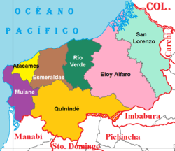 Cantons of Esmeraldas Province | |
| Coordinates: 0°58′00″S 79°39′00″W | |
| Country | Ecuador |
| Established | September 21, 1526 |
| Capital | Esmeraldas |
| Cantons | List of Cantons |
| Government | |
| • Provincial Prefect | Linder Altafuya (MUP) |
| Area | |
| • Total | 16,132.23 km2 (6,228.69 sq mi) |
| Population (2010 census) | |
| • Total | 534,092 |
| • Density | 33/km2 (86/sq mi) |
| Vehicle registration | E |
| HDI (2017) | 0.718[1] high · 16th |
The province is home to the Afro-Ecuadorian culture.
Demographics
Ethnic groups as of the Ecuadorian census of 2010:[2]
- Mestizo 44.7%
- Afro-Ecuadorian 43.9%
- White 5.9%
- Indigenous 2.8%
- Montubio 2.4%
- Other 0.3%
Cantons
The province is divided into 7 cantons. The following table lists each with its population at the time of the 2001 census, its area in square kilometres (km²), and the name of the canton seat or capital.[3]
| Canton | Pop. (2019) | Area (km²) | Seat/Capital |
|---|---|---|---|
| Atacames | 54,200 | 511 | Atacames |
| Eloy Alfaro | 45,270 | 4,302 | Valdez (a.k.a. Limones) |
| Esmeraldas | 216,900 | 1,351 | Esmeraldas |
| Muisne | 31,030 | 1,265 | Muisne |
| Quinindé | 144,200 | 3,855 | Rosa Zárate (a.k.a. Quinindé) |
| Río Verde | 31,160 | 1,506 | Rioverde |
| San Lorenzo | 60,660 | 3,106 | San Lorenzo |
Parroquias (Parishes)
The cantons are divided into many parroquias:
In Muisne:
- Bellavista
- Daule
- Maldonado
- Muisne
- Pedro Carlo
- Tola
- Union of Daule
See also
References
| Wikimedia Commons has media related to Esmeraldas Province. |
- Villalba, Juan. "Human Development Index in Ecuador". Scribd (in Spanish). Retrieved 2019-02-05.
- Instituto Nacional de Estadística y Censos. "Resultados |". Ecuadorencifras.gob.ec. Retrieved 2018-12-24.
- Cantons of Ecuador. Statoids.com. Retrieved 4 November 2009.
This article is issued from Wikipedia. The text is licensed under Creative Commons - Attribution - Sharealike. Additional terms may apply for the media files.