Ambelau
Ambelau or Ambalau is a volcanic island in the Banda Sea within Maluku Islands of Indonesia. The island forms an administrative district (Indonesian: Kecamatan Ambalau) which is part of the South Buru Regency (Indonesian: Kabupaten Buru Selatan) of Maluku province (Indonesian: Provinsi Maluku), Indonesia. It has a land area of 201.7 km2, and had a population of 6,846 at the 2010 Census.[1] The administrative center is Wailua, a settlement located at the south of the island. About half of the island's population is composed of indigenous Ambelau people who speak the Ambelau language; the other half are mostly immigrants from the nearby Maluku Islands and Java.
 | |
 Ambelau Location in Indonesia | |
| Geography | |
|---|---|
| Location | South East Asia |
| Coordinates | 3°51′20″S 127°11′30″E |
| Archipelago | Greater Sunda Islands |
| Area | 201.7 km2 (77.9 sq mi) |
| Highest elevation | 608 m (1,995 ft) |
| Highest point | unnamed |
| Administration | |
| Province | Maluku |
| Regency | South Buru Regency |
| Largest settlement | Wailua |
| Demographics | |
| Population | 6,846 (2010 Census) |
| Pop. density | 33.9/km2 (87.8/sq mi) |
| Languages | Ambelau language |
| Additional information | |
| Time zone | |
Geography and geology
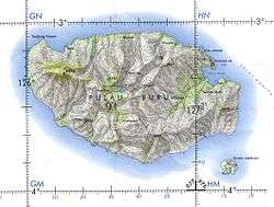
The island is located in the Banda Sea at the southern entrance to the strait Manipa, about 20 km south-east of the larger island of Buru. It has a relatively smooth oval shape with a minor extension in the south-eastern part and the maximum diameter of about 10 km.[2]
The island is of volcanic origin, and is composed of Cenozoic sedimentary rocks. The relief is mostly mountainous, with the highest points at 608 m (Mt. Baula) and 559 m (Mt. Nona) in the western area.[3] The island rises vertically from the sea, and flat parts are found only on the southern and eastern coasts. Much of the territory, especially in mountainous areas, is covered with wet tropical forests.[4] The island is located in a seismically active zone with frequent earthquakes; two significant recent earthquakes occurred in August 2006[5] and January 2016 when eight people were hurt and about 120 houses were damaged in two villages.[6] Flora and fauna of the island are diverse and are similar to that of Buru. There are abundant coral reefs off the coast of Ambelau.[4]
Administration
The island belongs to the Indonesian province of Maluku. Until 1999 the island belonged to the Central Maluku Regency (Indonesian: Kabupaten Maluku Tengah), then to the Buru Regency (Indonesian: Kabupaten Buru), in which it was isolated into a separate administrative district (Kecamatan Ambalau).[7] In 2008, when the South Buru Regency split up from the Buru Regency, the island became part of it, maintaining its kecamatan status.[8] The island is divided into seven administrative units of lower rank, called village (Indonesian: desa) or settlement (Indonesian: kelurahan), namely Kampung Baru, Lumoy, Masawoy, Selasi, Siwar, Ulima and Elara.[2][4]
Phonetics of the local languages reduces the vowel in the second syllable of the island name. As a result, Western sources refer to it as Ambelau, whereas modern Indonesian sources spell the name as Ambalau, particularly in official documents and on the official website of the Buru and South Buru regencies.[2]
Population
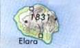
The majority of Ambelau's population (6,846 at the 2010 census) resides on the coastal plains, in the settlements of Kampung Baru (969), Lumoy (1,209), Masawoy (750), Selasi (606), Siwar (890), Ulima (970) and Elara (1,452).[4] About half of the population are indigenous Ambelau people, and another half are immigrants from other Maluku Islands belonging to Sulawesi (mainly Bugis) and Javanese ethnicities. The latter moved to the island mainly through the large-scale transmigration programs supported by both the Dutch colonial administration in the 1900s and the Indonesian authorities in the 1950s–1990s. The individual ethnic groups speak different languages and dialects in everyday life, for example Ambelau language. However, most adults have knowledge of the national Indonesian language and use it in public or in communication with other tribes. By religion, most Ambelau residents are Sunni Muslims, with a small part of Christians and with some remnants of traditional local beliefs.[4]
Economy
Agriculture dominates the local economy. Cultivation of rice – the most common crop of the region – is hindered on Ambelau by the hilly terrain and abundance of the wild pig Buru babirusa damaging the crops (which is rarely hunted because of the Muslim traditions). The small terrains of fertile land on the coast are used to grow maize, sago sweet potato, cocoa, coconut, allspice and nutmeg. Tuna fishing is practiced by the villages of Masawoy and Ulimo. Some agricultural and fish products are exported to the nearby Buru islands, mainly on the markets of the town Namlea.[4]
References
- Biro Pusat Statistik, Jakarta, 2011.
- "Pemekaran BURSEL" (in Indonesian). Pemerintah Kabupaten Buru (Official site of Buru Regency). 29 November 2007. Archived from the original on 2011-08-19. Retrieved 27 March 2010.
- National Geospatial-intelligence Agency (2004). Prostar Sailing Directions 2004 New Guinea Enroute. ProStar Publications. p. 46. ISBN 978-1-57785-569-9.
- "Local knowledge and fisheries management" (PDF). Center for Coastal and Marine Resources Studies, Bogor Agricultural University. Archived from the original (PDF) on 2011-07-23. Retrieved 2010-11-03.
- "Tremor jolts Banda Sea". Antara. 15 August 2006.
- "Indonesia earthquake injures eight, damages houses". Agence France Presse. January 17, 2016. Retrieved January 17, 2016.
- "Undang-Undang Republik Indonesia (UU) Nomor 46 tahun 1999 (46/1999) tentang Pembentukan Propinsi Maluku Utara, Kabupaten Buru, dan Kabupaten Maluku Tenggara Barat (Indonesian Law No. 46 of 1999 establishing provinces North Maluku, Buru and North-eastern Mauluku)" (PDF) (in Indonesian). LL Sekretariat Negara.
- "Undang-Undang Republik Indonesia Nomor 32 Tahun 2008 tentang Pembentukan Pembentukan Kabupaten Buru Selatan di Provinsi Maluku (Indonesian Law No. 32 of 2008 establishing south Buru district in the Maluku province)" (PDF) (in Indonesian). LL Sekretariat Negara. Archived from the original (PDF) on 2011-08-19. Retrieved 2010-11-03.