Pearl City, Hawaii
Pearl City is an unincorporated community and census-designated place (CDP) located in the ʻEwa District and City & County of Honolulu on the Island of Oʻahu. As of the 2010 Census, the CDP had a total population of 47,698. Pearl City is located along the north shore of Pearl Harbor. Waimalu borders Pearl City to the east, while Waipahu borders the west. The U.S. postal code for Pearl City is 96782.
Pearl City | |
|---|---|
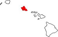
 Location in Honolulu County and the state of Hawaii | |
 Pearl City Location in Hawaii | |
| Coordinates: 21°24′30″N 157°58′1″W | |
| Country | |
| State | |
| County | |
| Area | |
| • Total | 5.8 sq mi (15.0 km2) |
| • Land | 5.0 sq mi (12.9 km2) |
| • Water | 0.8 sq mi (2.1 km2) |
| Elevation | 89 ft (27 m) |
| Population (2010) | |
| • Total | 47,698 |
| • Density | 6,215.5/sq mi (2,399.8/km2) |
| Time zone | UTC−10:00 (Hawaii-Aleutian) |
| ZIP Code | 96782 |
| Area code(s) | 808 |
| FIPS code | 15-62600 |
| GNIS feature ID | 0363226 |
History
Early-day Pearl City had an array of rice paddies and fields that were plowed with water buffalo that would haul a two-wheeled cart. In the early 1880s, Pearl City was the final stop for Benjamin Franklin Dillingham's Oahu Railway, a mud wagon driven by a four-horse team. Lots for an as-yet-to-exist "Pearl City" went on sale in 1889, after completion of the actual rail line.[1] Near the outskirts of Pearl City, the Remond Grove, an area where people could be entertained with piano, banjo, trumpet, and saxophone performances, was a popular entertainment spot in the early 1900s.
Geography
Pearl City is located at 21°24'30" North, 157°58'1" East (21.408333, −157.966902).[2]
According to the United States Census Bureau, the CDP has a total area of 5.8 square miles (15 km2), of which, 5.0 square miles (13 km2) of it is land and 0.8 square miles (2.1 km2) of it is water. The total area is 14.29% water.
Demographics
| Historical population | |||
|---|---|---|---|
| Census | Pop. | %± | |
| 1970 | 19,552 | — | |
| 1980 | 42,575 | 117.8% | |
| 1990 | 30,993 | −27.2% | |
| 2000 | 30,976 | −0.1% | |
| 2010 | 47,698 | 54.0% | |
| U.S. Decennial Census[5] 1790–1960[6] 1900–1990[7] 1990–2000[8] 2010–2015 | |||
As of the census[9] of 2010, there were 47,698 people, 14,622 households, and 7,288 families residing in the CDP. The population density was 6,215.5 people per square mile (2,401.6/km²). There were 9,181 housing units at an average density of 1,842.2 per square mile (711.8/km²). The racial makeup of the CDP was 59.57% Asian-Pacific Islander, 17.24% White, 2.71% African American, 0.27% Native American, 1.41% from other races, and 18.81% from two or more races. 7.30% of the population were Hispanic or Latino of any race.
There were 8,922 households out of which 25.2% had children under the age of 18 living with them, 63.9% were married couples living together, 12.3% had a female householder with no husband present, and 18.3% were non-families. 14.9% of all households were made up of individuals and 6.6% had someone living alone who was 65 years of age or older. The average household size was 3.17 and the average family size was 3.48.
In the CDP, the population was spread out with 18.8% under the age of 18, 13.7% from 18 to 24, 27.2% from 25 to 44, 23.2% from 45 to 64, and 17.1% who were 65 years of age or older. The median age was 37 years. For every 100 females, there were 115.2 males. For every 100 females age 18 and over, there were 117.3 males.
The median income for a household in the CDP was $62,036, and the median income for a family was $67,246. Males had a median income of $30,712 versus $28,408 for females. The per capita income for the CDP was $21,683. 6.2% of the population and 4.0% of families were below the poverty line. Out of the total population, 11.7% of those under the age of 18 and 4.1% of those 65 and older were living below the poverty line.
Government and infrastructure
The Honolulu Police Department operates the Pearl City Substation in Pearl City.[10]
The United States Postal Service operates the Pearl City Post Office in Pearl City.[11]
Education
The Hawai'i Department of Education operates the Pearl City Complex public schools that include elementary, intermediate, and high schools.
Elementary schools in the Pearl City CDP include Manana, Our Lady of Good Counsel, Palisades, Pearl City, and Pearl City Highlands.[12] Momilani and Waiau elementary schools are in the adjacent Waimalu CDP.[13] Highlands Intermediate School is within the Pearl City CDP.[12] Pearl City High School is in Waimalu CDP.[13]
The University of Hawaii–Leeward Community College, a branch of the University of Hawaii system, is located in Pearl City.[14]
Sports and recreation
In 1998, a Pearl City baseball team—Pearl City Little League (District 7)—represented the U.S. and made it to the Little League World Series finals where they lost to the team from Taipei. In 2007, they won the Junior League World Series, after winning the West Region, then defeating the Central Region and Southwest Region champions to become the U.S. champion, and finally defeating the International champion (Asia-Pacific Region), Illam Central LL (Makati City, Philippines), 6–2.
The Hawaii Hawks won the 2003 Field Hockey World Cup 10–7.
In 2017, a Pearl City youth baseball team, the Pearl City KRU, represented the Pacific Southwest region in the Cal Ripken Baseball 10U (age 10 and under) World Series. This series was held in Hammond, Indiana, which hosted nine other teams from across the country. The KRU team won all of their games in pool play, and made it to the World Series finals, where they lost to the team from West Raleigh, North Carolina, by a score of 5-3.[15]
Notable people
- Brook Lee, Miss Hawaii USA 1997, Miss USA 1997 and Miss Universe 1997
- Jason Scott Lee, film actor noted for his roles in Dragon: The Bruce Lee Story, Kipling's The Jungle Book, and Lilo & Stitch
- Duke Aiona, former Lieutenant Governor of Hawaii, born in Pearl City
- David Ige, Governor of Hawaii, born in Pearl City
References
- Leong, Lavonne (November 2012). "Honolulu in 1888: The City That Made the Magazine". Honolulu Magazine: 102. Retrieved May 25, 2016.
- "US Gazetteer files: 2010, 2000, and 1990". United States Census Bureau. 2011-02-12. Retrieved 2011-04-23.
- "Average Weather in Pearl City Hawaii, United States", Weather Spark, retrieved 6 March 2019.
- "Climate in Pearl City, Hawaii", Best Places, retrieved 6 March 2019.
- "U.S. Decennial Census". United States Census Bureau. Retrieved October 4, 2015.
- "Historical Census Browser". University of Virginia Library. Retrieved October 4, 2015.
- Forstall, Richard L., ed. (March 27, 1995). "Population of Counties by Decennial Census: 1900 to 1990". United States Census Bureau. Retrieved October 4, 2015.
- "Census 2000 PHC-T-4. Ranking Tables for Counties: 1990 and 2000" (PDF). United States Census Bureau. April 2, 2001. Retrieved October 4, 2015.
- "U.S. Census website". United States Census Bureau. Retrieved 2008-01-31.
- "Contacting HPD Archived 2010-05-31 at the Wayback Machine." Honolulu Police Department. Retrieved on May 19, 2010.
- "Post Office Location – PEARL CITY Archived 2011-02-18 at the Wayback Machine." United States Postal Service. Retrieved on May 19, 2010.
- "Pearl City CDP Archived 2009-08-05 at the Wayback Machine." U.S. Census Bureau. Retrieved on May 21, 2009.
- "Waimalu CDP, Hawaii Archived 2009-08-05 at the Wayback Machine." U.S. Census Bureau. Retrieved on May 21, 2009.
- "." Retrieved on October 23, 2014.
- Ball, Payton. "Crown Point wins Iron Bracket; West Raleigh captures 10u Championship". nwitimes.com. Retrieved Jun 20, 2020.
External links

Honolulu (capital) | ||
| Topics | ||
| Society | ||
| Main islands | ||
| Northwestern Islands | ||
| Communities | ||
| Counties | ||
| Sovereignty Movement | ||
Islands, municipalities, and communities of Honolulu County, Hawaii, United States | ||
|---|---|---|
| CDPs |
|  Map of Hawaii highlighting Honolulu County |
| Other communities | ||
| Authority control |
|
|---|