Depopulation of the Great Plains
The depopulation of the Great Plains refers to the large-scale migration of people from rural areas of the Great Plains of the United States to more urban areas and to the east and west coasts during the 20th century. This phenomenon of rural-to-urban migration has occurred to some degree in most areas of the United States, but has been especially pronounced in the Great Plains states, including Texas, Oklahoma, Kansas, Nebraska, South Dakota, North Dakota, Montana, Wyoming, Colorado, and New Mexico, where many counties have lost more than 60 percent of their former populations.

Depopulation began in the early 1900s, accelerated in the Dust Bowl years of the 1930s, and has generally continued through the national census in 2010. The population decline has been broadly attributed to numerous factors, especially changes in agricultural practices, rapid improvements in urban transit and regional connectivity, and a steadily faltering rural job market.
Geography

Definitions vary as to what land comprises the Great Plains, but the Plains are generally agreed to overlap with the territory of ten states: Colorado, Kansas, Montana, Nebraska, New Mexico, North Dakota, Oklahoma, South Dakota, Texas and Wyoming. The eastern boundary is about 97 degrees W longitude and the Plains extend westward to the Rocky Mountains and southward from the border with Canada to the approximate latitude of Austin, Texas.[1] A somewhat more restrictive definition by the U.S. Census Bureau gives a total area of the Great Plains in the United States as 533,100 square miles (1,381,000 km2), 18 percent of the area of the entire United States.[2]
The Great Plains are distinguished by generally flat land and a natural vegetation cover consisting mostly of expansive grasslands. The eastern part of the Great Plains is nearly completely dominated by agriculture, with wheat being the most common and important crop. The western part is more arid and is primarily used for grazing cattle and irrigated agriculture.
Population history
Large-scale settlement of the Great Plains by farmers and ranchers began with the end of the Civil War in 1865. By the late 1870s the Plains Indians had been defeated militarily and were largely confined to reservations. Drawn by the free land made available by the Homestead Act, pioneer families quickly settled the region such that nearly all of the arable land was privately owned or on Indian reservations by 1900.
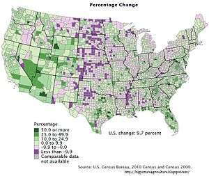
The initial rush to settle the Great Plains by hundreds of thousands of farmers and ranchers has been reversed because of several factors. Perhaps the most significant reasons have been economic. Over the course of the 20th century, farm economies saw dramatic shifts from small-scale family subsistence farming to larger commercial farms utilizing more equipment and less labor.[3] Many family farms proved to be too small to survive. Farmers also used farming techniques which were unsuited to the dry, windy climate and the frequent droughts of the Great Plains. This became manifest during the Dust Bowl years of the 1930s, in which rural flight from the Great Plains accelerated, although the decline in population of some counties had begun as early as 1900.[4] Better roads and the automobile permitted many farmers to live in larger towns and cities rather than on the farm itself. While urban areas on the Great Plains more than doubled in population, thousands of small towns and communities disappeared. Two-thirds of counties lost some part of their population between the early 1900s and the 2010 census, and, as the table below demonstrates, many rural counties lost more than 60 percent of their population. A few counties lost more than 80 percent of their population. Population density of some Great Plains counties dipped below two persons per square mile.[5][6][7]
Governments have tried a variety of methods to stem the outflow of population from rural areas in the Great Plains. Some towns have offered free building lots to prospective residents, but the program has met with only limited success. The fundamental problem appears to be the few employment opportunities available in these small and isolated communities.[8]
The population decline has led to proposals to return the land to its natural state and under public ownership. The Buffalo Commons proposal calls for large portions of the drier regions of the Great Plains to be returned to their original condition as pasture land for American bison and other plains animals.[9]
Counties with large population losses
The following Great Plains counties lost more than 60 percent of their population between 1900 and 2010.
| State and county name | Area in square miles (km sq) (includes both land and water area) | Greatest population (census year) | 2010 population | Percentage decline in population | 2010 population density per sq. mi |
|---|---|---|---|---|---|
| Colorado | |||||
| Baca | 2,557 square miles (6,620 km2) | 10,570 (1930) | 3,788 | -64.8 | 1.5 |
| Huerfano | 1,593 square miles (4,130 km2) | 17,062 (1930) | 6,711 | -60.7 | 4.2 |
| Kiowa | 1,786 square miles (4,630 km2) | 3,786 (1930) | 1,398 | -63.1 | 0.8 |
| Kansas | |||||
| Cheyenne | 1,021 square miles (2,640 km2) | 6,948 (1930) | 2,726 | -60.8 | 2.7 |
| Comanche | 790 square miles (2,000 km2) | 5,302 (1920) | 1,891 | -64.3 | 2.4 |
| Decatur | 894 square miles (2,320 km2) | 9,234 (1900) | 2,961 | -67.9 | 3.3 |
| Graham | 899 square miles (2,330 km2) | 8,700 (1910) | 2,597 | -70.1 | 2.9 |
| Jewell | 914 square miles (2,370 km2) | 19,420 (1900) | 3,077 | -84.2 | 3.4 |
| Lincoln | 720 square miles (1,900 km2) | 10,142 (1910) | 3,241 | -68.0 | 4.5 |
| Osborne | 864 square miles (2,240 km2) | 12,827 (1910) | 3,858 | -69.9 | 4.5 |
| Phillips | 895 square miles (2,320 km2) | 14,442 (1900) | 5,642 | -60.9 | 6.3 |
| Rawlins | 1,070 square miles (2,800 km2) | 6,790 (1920) | 2,519 | -62.9 | 2.4 |
| Republic | 720 square miles (1,900 km2) | 18,248 (1900) | 4,980 | -72.7 | 6.9 |
| Rush | 718 square miles (1,860 km2) | 9,093 (1930) | 3,307 | -63.6 | 4.6 |
| Smith | 897 square miles (2,320 km2) | 16,384 (1900) | 3,853 | -76.5 | 4.3 |
| Stafford | 795 square miles (2,060 km2) | 12,510 (1910) | 4,437 | -64.5 | 5.6 |
| Washington | 899 square miles (2,330 km2) | 21,963 (1900) | 5,799 | -73.6 | 6.5 |
| Montana | |||||
| Carter | 3,348 square miles (8,670 km2) | 4,136 (1930) | 1,160 | -72.0 | 0.3 |
| Chouteau | 3,997 square miles (10,350 km2) | 17,191 (1910) | 5,813 | -66.2 | 1.5 |
| Daniels | 1,427 square miles (3,700 km2) | 5,553 (1930) | 1,751 | -68.5 | 0.8 |
| Garfield | 4,849 square miles (12,560 km2) | 5,368 (1920) | 1,206 | -77.5 | 0.2 |
| Judith Basin | 1,871 square miles (4,850 km2) | 5,238 (1930) | 2,072 | -60.4 | 0.5 |
| McCone | 2,682 square miles (6,950 km2) | 4,790 (1930) | 1,734 | -63.8 | 0.6 |
| Musselshell | 1,872 square miles (4,850 km2) | 12,030 (1930) | 4,538 | -62.3 | 2.4 |
| Petroleum | 1,675 square miles (4,340 km2) | 2,045 (1930) | 494 | -75.8 | 0.3 |
| Prairie | 1,742 square miles (4,510 km2) | 3,941 (1930) | 1,179 | -70.1 | 0.5 |
| Sheridan | 1,704 square miles (4,410 km2) | 13,847 (1920) | 3,384 | -75.6 | 1.9 |
| Treasure | 985 square miles (2,550 km2) | 1,990 (1920) | 718 | -63.9 | 0.7 |
| Wheatland | 1,428 square miles (3,700 km2) | 5,619 (1920) | 2,168 | -61.4 | 1.5 |
| Wibaux | 889 square miles (2,300 km2) | 3,113 (1920) | 1,017 | -67.3 | 1.1 |
| Nebraska | |||||
| Arthur | 718 square miles (1,860 km2) | 1,412 (1920) | 460 | -67.4 | 0.6 |
| Blaine | 714 square miles (1,850 km2) | 1,778 (1920) | 478 | -73.1 | 0.7 |
| Boyd | 546 square miles (1,410 km2) | 8,826 (1910) | 2,099 | -76.2 | 3.8 |
| Dundy | 921 square miles (2,390 km2) | 5,610 (1930) | 2,008 | -64.2 | 2.2 |
| Fillmore | 577 square miles (1,490 km2) | 15,087 (1900) | 5,890 | -61.0 | 9.8 |
| Franklin | 576 square miles (1,490 km2) | 10,303 (1910) | 3,225 | -68.7 | 5.6 |
| Frontier | 980 square miles (2,500 km2) | 8,781 (1900) | 2,756 | -68.6 | 2.8 |
| Gosper | 463 square miles (1,200 km2) | 5,301 (1900) | 2,044 | -61.4 | 4.4 |
| Greeley | 571 square miles (1,480 km2) | 8,685 (1920) | 2,538 | -70.8 | 2.9 |
| Harlan | 574 square miles (1,490 km2) | 9,578 (1910) | 3,423 | -64.3 | 6.0 |
| Hayes | 713 square miles (1,850 km2) | 3,603 (1930) | 967 | -73.2 | 1.4 |
| Keya Paha | 774 square miles (2,000 km2) | 3,594 (1920) | 763 | -78.8 | 1.0 |
| Logan | 571 square miles (1,480 km2) | 2,014 (1930) | 763 | -62.1 | 1.3 |
| Loup | 571 square miles (1,480 km2) | 2,188 (1910) | 632 | -71.1 | 1.1 |
| McPherson | 860 square miles (2,200 km2) | 2,470 (1910) | 539 | -78.8 | 0.6 |
| Pawnee | 433 square miles (1,120 km2) | 11,770 (1900) | 2,773 | -76.4 | 6.4 |
| Rock | 1,012 square miles (2,620 km2) | 3,977 (1940) | 1,526 | -61.6 | 1.5 |
| Sioux | 2,067 square miles (5,350 km2) | 5,599 (1910) | 1,311 | -76.6 | 0.6 |
| Thayer | 575 square miles (1,490 km2) | 14,775 (1910) | 5,228 | -64.6 | 9.1 |
| Thomas | 714 square miles (1,850 km2) | 1.773 (1920) | 647 | -63.5 | 0.9 |
| Webster | 575 square miles (1,490 km2) | 12,008 (1910) | 3,812 | -61.3 | 6.6 |
| Wheeler | 576 square miles (1,490 km2) | 2,531 (1920) | 818 | -67.7 | 1.4 |
| New Mexico | |||||
| Harding | 2,126 square miles (5,510 km2) | 4,421 (1930) | 695 | -84.3 | 0.3 |
| Mora | 1,933 square miles (5,010 km2) | 13,915 (1920) | 4,861 | -65.1 | 2.5 |
| Union | 3,831 square miles (9,920 km2) | 16,680 (1930) | 4,549 | -72.7 | 1.2 |
| North Dakota | |||||
| Adams | 989 square miles (2,560 km2) | 6,343 (1930) | 2,343 | -63.1 | 2.4 |
| Billings | 1,153 square miles (2,990 km2) | 3,126 (1920) | 783 | -75.0 | 0.7 |
| Bottineau | 1,698 square miles (4,400 km2) | 17,295 (1910) | 6,429 | -62.8 | 3.8 |
| Burke | 1,129 square miles (2,920 km2) | 9,998 (1930) | 1,968 | -80.3 | 1.7 |
| Cavalier | 1,510 square miles (3,900 km2) | 15,659 (1910) | 3,993 | -74.5 | 2.6 |
| Divide | 1,295 square miles (3,350 km2)} | 6,015 (1910) | 2,071 | -65.6 | 1.6 |
| Dunn | 2,082 square miles (5,390 km2) | 9,566 (1930) | 3,536 | -63.0 | 1.7 |
| Eddy | 695 square miles (1,800 km2) | 6,493 (1920) | 2,395 | -63.1 | 3.4 |
| Emmons | 1,555 square miles (4,030 km2) | 12,467 (1930) | 3,550 | -71.5 | 2.3 |
| Golden Valley | 1,002 square miles (2,600 km2) | 4,832 (1920) | 1,680 | -65.2 | 1.7 |
| Grant | 1,666 square miles (4,310 km2) | 10,134 (1930) | 2,394 | -76.4 | 1.4 |
| Griggs | 1,142 square miles (2,960 km2) | 7,402 (1920) | 2,420 | -67.3 | 3.4 |
| Hettinger | 1,134 square miles (2,940 km2) | 8,796 (1930) | 2,477 | -71.8 | 2.2 |
| Kidder | 1,433 square miles (3,710 km2) | 8,031 (1930) | 2,455 | -69.4 | 1.7 |
| LaMoure | 1,151 square miles (2,980 km2) | 11,517 (1930) | 4,139 | -64.1 | 3.6 |
| Logan | 1,011 square miles (2,620 km2) | 8,089 (1930) | 1,990 | -75.4 | 2.0 |
| McHenry | 1,912 square miles (4,950 km2) | 17,627 (1910) | 5,395 | -69.4 | 2.8 |
| McIntosh | 995 square miles (2,580 km2) | 9,621 (1930) | 2,809 | -70.8 | 2.8 |
| Nelson | 1,009 square miles (2,610 km2) | 10,312 (1920) | 3,126 | -69.7 | 3.1 |
| Renville | 892 square miles (2,310 km2) | 7,840 (1910) | 2,450 | -68.7 | 2.8 |
| Sargent | 867 square miles (2,250 km2) | 9,655 (1920) | 3,829 | -60.3 | 4.4 |
| Sheridan | 1,006 square miles (2,610 km2) | 8,103 (1910) | 1,321 | -83.7 | 1.3 |
| Slope | 1,219 square miles (3,160 km2) | 4,940 (1920) | 727 | -85.3 | 0.6 |
| Steele | 715 square miles (1,850 km2) | 7,616 (1910) | 1975 | -74.1 | 2.8 |
| Towner | 1,042 square miles (2,700 km2) | 8,963 (1910) | 2,246 | -74.9 | 2.2 |
| Wells | 1,291 square miles (3,340 km2) | 13,285 (1930) | 4,207 | -68.3 | 3.3 |
| Oklahoma | |||||
| Alfalfa | 881 square miles (2,280 km2) | 18,138 (1910) | 5,642 | -68.9 | 6.4 |
| Cotton | 642 square miles (1,660 km2) | 16,679 (1920) | 6,193 | -62.9 | 9.6 |
| Dewey | 1,008 square miles (2,610 km2) | 14,132 (1910) | 4,810 | -66.0 | 4.8 |
| Ellis | 1,232 square miles (3,190 km2) | 15,375 (1910) | 4,151 | -73.0 | 3.4 |
| Grant | 1,004 square miles (2,600 km2) | 18,760 (1910) | 4,527 | -75.9 | 4.5 |
| Greer | 644 square miles (1,670 km2) | 17,922 (1900) | 6,239 | -65.2 | 9.7 |
| Harmon | 539 square miles (1,400 km2) | 13,834 (1930) | 2,922 | -78.8 | 5.4 |
| Jefferson | 774 square miles (2,000 km2) | 17,764 (1920) | 6,472 | -63.6 | 8.4 |
| Kiowa | 1,031 square miles (2,670 km2) | 29,630 (1930) | 9,446 | -68.1 | 9.2 |
| Roger Mills | 1,146 square miles (2,970 km2) | 14,164 (1930) | 3,647 | -74.3 | 3.2 |
| Tillman | 879 square miles (2,280 km2) | 24,390 (1930) | 7,992 | -67.2 | 9.1 |
| Washita | 1,009 square miles (2,610 km2) | 29,435 (1930) | 11,629 | -60.5 | 11.5 |
| South Dakota | |||||
| Aurora | 713 square miles (1,850 km2) | 7,246 (1920) | 2,710 | -62.6 | 3.8 |
| Campbell | 771 square miles (2,000 km2) | 5,629 (1930) | 1,466 | -74.0 | 2.0 |
| Clark | 968 square miles (2,510 km2) | 11,136 (1920) | 3,691 | -66.9 | 3.9 |
| Day | 1,091 square miles (2,830 km2) | 15,194 (1920) | 5,710 | -62.4 | 5.8 |
| Faulk | 1,006 square miles (2,610 km2) | 6,895 (1930) | 2,364 | -65.7 | 2.4 |
| Gregory | 1,053 square miles (2,730 km2) | 13,061 (1910) | 4,271 | -67.3 | 4.2 |
| Hand | 1,440 square miles (3,700 km2) | 9,485 (1930) | 3,431 | -63.8 | 2.4 |
| Harding | 2,678 square miles (6,940 km2) | 4,228 (1910) | 1,255 | -69.3 | 0.5 |
| Hyde | 867 square miles (2,250 km2) | 3,690 {1930) | 1,420 | -61.5 | 1.7 |
| Jerauld | 533 square miles (1,380 km2) | 6,338 (1920) | 2,071 | -67.3 | 3.9 |
| Jones | 1,003 square miles (2,600 km2) | 3,177 (1930) | 1,008 | -68.3 | 1.0 |
| Lyman | 1,707 square miles (4,420 km2) | 10,848 (1910) | 3,755 | -61.1 | 2.3 |
| McPherson | 1,152 square miles (2,980 km2) | 8,774 (1930) | 2,469 | -71.9 | 2.2 |
| Melette | 1,310 square miles (3,400 km2) | 5,293 (1930) | 2,048 | -61.3 | 1.8 |
| Miner | 572 square miles (1,480 km2) | 8,560 (1920) | 2,389 | -72.1 | 4.2 |
| Perkins | 2,891 square miles (7,490 km2) | 11,348 (1910) | 2,982 | -73.7 | 1.0 |
| Sanborn | 570 square miles (1,500 km2) | 7,877 (1920) | 2,365 | -70.0 | 4.1 |
| Sully | 1,070 square miles (2,800 km2) | 3,852 (1930) | 1,373 | -64.4 | 1.4 |
| Texas | |||||
| Briscoe | 902 square miles (2,340 km2) | 5,590 (1930) | 1,637 | -72.7 | 1.8 |
| Coleman | 1,281 square miles (3,320 km2) | 23,669 (1930) | 8,895 | -62.4 | 6.9 |
| Collingsworth | 919 square miles (2,380 km2) | 14,461 (1930) | 3,057 | -78.9 | 3.3 |
| Cottle | 902 square miles (2,340 km2) | 9,395 (1930) | 1,505 | -84.0 | 1.7 |
| Dickens | 905 square miles (2,340 km2) | 8,601 (1930) | 2,444 | -71.6 | 2.7 |
| Donley | 933 square miles (2,420 km2) | 10,262 (1930) | 3,677 | -64.2 | 3.9 |
| Eastland | 932 square miles (2,410 km2) | 58,565 (1920) | 18,583 | -68.3 | 19.9 |
| Fisher | 902 square miles (2,340 km2) | 13,565 (1930) | 3,974 | -71.5 | 4.4 |
| Foard | 708 square miles (1,830 km2) | 6,315 (1930) | 1,336 | -78.9 | 1.9 |
| Hall | 904 square miles (2,340 km2) | 16,966 (1930) | 3,353 | -80.2 | 3.7 |
| Hardeman | 697 square miles (1,810 km2) | 14,532 (1930) | 4,139 | -71.5 | 5.9 |
| Haskell | 910 square miles (2,400 km2) | 16,669 (1930) | 5,899 | -64.6 | 6.5 |
| Kent | 903 square miles (2,340 km2) | 3,851 (1930) | 808 | -79.0 | 0.9 |
| King | 913 square miles (2,360 km2) | 1,193 (1930) | 286 | -76.0 | 0.3 |
| Knox | 855 square miles (2,210 km2) | 11,368 (1930) | 3,719 | -67.3 | 4.3 |
| Loving | 677 square miles (1,750 km2) | 285 (1930) | 82 | -71.2 | 0.1 |
| Motley | 990 square miles (2,600 km2) | 6,812 (1930) | 1,210 | -82.2 | 1.2 |
| Stonewall | 920 square miles (2,400 km2) | 5,667 (1930) | 1,490 | -73.7 | 1.6 |
| Throckmorton | 915 square miles (2,370 km2) | 5,253 (1930) | 1,641 | -68.8 | 1.8 |
| Wheeler | 915 square miles (2,370 km2) | 15,555 (1930) | 5,410 | -65.2 | 5.9 |
| Wyoming | |||||
| Niobrara | 2,628 square miles (6,810 km2) | 6,321 (1920) | 2,484 | -60.7 | 0.9 |
Sources: "County Population Census Counts, 1900-1990", accessed 29 April 2013; "USA counties", accessed 29 April 2013
See also
References
- Wishart, David. 2004. "The Great Plains Region", In: Encyclopedia of the Great Plains, Lincoln: University of Nebraska Press, pp. xiii-xviii. ISBN 0-8032-4787-7
- Wilson, S.G., "Population Dynamics of the Great Plains, 1950-2007", accessed 7 May 2013
- Cronon, William (1991). Nature's Metropolis: Chicago and the Great West. New York: Norton.
- Cooper, Michael L. (2004). Dust to eat: drought and depression in the 1930s. New York: Clarion.
- "Free land fails to draw new homesteaders to Kansas towns" Archived 2013-11-28 at the Wayback Machine, McClatchy, March 15, 2013, accessed 6 May 2013
- "Population flight from growing desert of central Texas".
- "Where the Buffalo Roam".
- accessed 6 May 2013
- Deborah Epstein Popper and Frank J. Popper, "Great Plains: From Dust to Dust", Planning, December 1987