Denver–Aurora combined statistical area
The United States Office of Management and Budget has defined the Denver–Aurora, CO Combined Statistical Area comprising the Denver–Aurora–Lakewood, CO Metropolitan Statistical Area, the Boulder, CO Metropolitan Statistical Area, and the Greeley, CO Metropolitan Statistical Area.[1] The United States Census Bureau estimates that the population was 3,214,218 as of July 1, 2012, an increase of +3.99% since the 2010 United States Census, and ranking as the 16th most populous metropolitan combined statistical area and the 17th most populous primary statistical area of the United States.[2][3] The population estimate for 2016 is 3,412,607.[4]
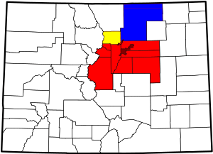
Counties
The Denver–Aurora CSA comprises the Denver–Aurora–Lakewood, CO Metropolitan Statistical Area, the Boulder, CO Metropolitan Statistical Area, and the Greeley, CO Metropolitan Statistical Area. The table below includes the following information:
- The name of the constituent Core Based Statistical Area (CBSA).[5]
- The population of the CBSA as of July 1, 2007, as estimated by the United States Census Bureau.[6]
- The population of the county as of July 1, 2014, as estimated by the United States Census Bureau.[7]
- The county population as of April 1, 2010, as enumerated by the 2010 United States Census,[7] and
- The percent county population change from April 1, 2010, to July 1, 2014.
- The population of the county as of July 1, 2016, as estimated by the United States Census Bureau.[8]
| Core Based Statistical Area | 2014 estimate | County | 2014 estimate | 2010 Census | Change | 2016 estimate |
|---|---|---|---|---|---|---|
| Denver–Aurora–Lakewood, CO MSA | 2,754,308 | City and County of Denver | 663,862 | 600,158 | +10.61% | 693,060 |
| Arapahoe County | 618,821 | 572,003 | +8.18% | 637,068 | ||
| Jefferson County | 558,503 | 534,543 | +4.48% | 571,837 | ||
| Adams County | 480,718 | 441,603 | +8.86% | 498,187 | ||
| Douglas County | 314,638 | 285,465 | +10.22% | 328,362 | ||
| City and County of Broomfield | 62,188 | 55,889 | +11.27% | 66,529 | ||
| Elbert County | 24,195 | 23,086 | +4.80% | 25,231 | ||
| Park County | 16,345 | 16,101 | +1.52% | 17,166 | ||
| Clear Creek County | 9,187 | 9,088 | +1.09% | 9,436 | ||
| Gilpin County | 5,851 | 5,441 | +7.54% | 5,931 | ||
| Boulder, CO MSA | 313,333 | Boulder County | 313,333 | 294,567 | +6.37% | 322,226 |
| Greeley, CO MSA | 277,670 | Weld County | 277,670 | 252,825 | +9.83% | 294,932 |
| Total for Denver–Aurora, CO CSA | 3,345,261 | 3,090,874 | +8.23% | 3,469,965 | ||
Components
The Denver-Aurora CSA includes, all in the State of Colorado:
- the Town of Alma
- the City of Arvada
- the Town of Ault
- the City of Aurora, the Town of Bennett
- the portion of the Town of Berthoud in Weld County
- the City of Black Hawk
- the City of Boulder, the Town of Bow Mar
- the City of Brighton
- the City and County of Broomfield
- the City of Castle Pines North
- the Town of Castle Rock
- the City of Centennial
- Central City
- the City of Cherry Hills Village
- the Town of Columbine Valley
- the City of Commerce City
- the City of Dacono
- the Town of Deer Trail
- the City and County of Denver, the Town of Eaton
- the City of Edgewater
- the Town of Elizabeth
- the Town of Empire
- the City of Englewood
- the Town of Erie
- the City of Evans
- the Town of Fairplay
- the City of Federal Heights
- the Town of Firestone
- the City of Fort Collins
- the Town of Foxfield
- the Town of Frederick
- the Town of Garden City
- the Town of Georgetown
- the Town of Gilcrest
- the City of Glendale
- the City of Golden
- the City of Greeley
- the City of Greenwood Village
- the Town of Grover
- the Town of Hudson
- the City of Idaho Springs
- the Town of Jamestown
- the portion of the Town of Johnstown in Weld County
- the Town of Keenesburg
- the Town of Kersey
- the Town of Kiowa
- the Town of La Salle
- the City of Lafayette
- the Town of Lakeside
- the City of Lakewood
- the Town of Larkspur
- the City of Littleton
- the Town of Lochbuie
- the City of Lone Tree
- the City of Longmont
- the City of Louisville
- the Town of Lyons
- the Town of Mead
- the Town of Milliken
- the Town of Morrison
- the Town of Mountain View
- the Town of Nederland
- the City of Northglenn
- the Town of Nunn
- the Town of Parker
- the Town of Pierce
- the Town of Platteville
- the Town of Raymer
- the Town of Severance
- the City of Sheridan
- the Town of Silver Plume
- the Town of Simla
- the Town of Superior
- the City of Thornton
- the Town of Ward
- the Town of Watkins
- the City of Westminster
- the City of Wheat Ridge
- the portion of the Town of Windsor in Weld County
- unincorporated Adams County
- unincorporated Arapahoe County
- unincorporated Boulder County
- unincorporated Clear Creek County
- unincorporated Douglas County
- unincorporated Elbert County
- unincorporated Gilpin County
- unincorporated Jefferson County
- unincorporated Park County, and
- unincorporated Weld County.
See also
- Colorado census statistical areas
- Combined Statistical Area
- Core Based Statistical Area
- Metropolitan Statistical Area
- Micropolitan Statistical Area
- Table of United States Combined Statistical Areas
- Table of United States Metropolitan Statistical Areas
- Table of United States Micropolitan Statistical Areas
- Table of United States primary census statistical areas
- Core Based Statistical Areas of the Denver–Aurora, CO Combined Statistical Area:
- Boulder Metropolitan Statistical Area
- Denver-Aurora Metropolitan Statistical Area
- Greeley Metropolitan Statistical Area
- Core Based Statistical Areas adjacent to the Denver–Aurora, CO Combined Statistical Area:
- Cañon City Micropolitan Statistical Area
- Cheyenne Metropolitan Statistical Area
- Colorado Springs Metropolitan Statistical Area
- Edwards Micropolitan Statistical Area
- Fort Collins-Loveland Metropolitan Statistical Area
- Fort Morgan Micropolitan Statistical Area
- Silverthorne Micropolitan Statistical Area
- Sterling Micropolitan Statistical Area
- Other definitions of the Colorado urban areas:
- Colorado metropolitan areas
- Denver Metropolitan Area
- Front Range Urban Corridor
- North Central Colorado Urban Area
- 2013 Colorado floods
References
- "OMB Bulletin No. 13-01: Revised Delineations of Metropolitan Statistical Areas, Micropolitan Statistical Areas, and Combined Statistical Areas, and Guidance on Uses of the Delineations of These Areas" (PDF). United States Office of Management and Budget. February 28, 2013. Retrieved March 20, 2013.
- "Table 2. Annual Estimates of the Population of Combined Statistical Areas: April 1, 2010 to July 1, 2012". 2012 Population Estimates. United States Census Bureau, Population Division. March 2013. Archived from the original (CSV) on May 17, 2013. Retrieved March 20, 2013.
- "Table 1. Annual Estimates of the Population of Metropolitan and Micropolitan Statistical Areas: April 1, 2010 to July 1, 2012". 2012 Population Estimates. United States Census Bureau, Population Division. March 2013. Archived from the original (CSV) on April 1, 2013. Retrieved March 20, 2013.
- Bureau, U.S. Census. "U.S. Census website". United States Census Bureau. Retrieved 15 April 2018.
- The United States Census Bureau defines a Core Based Statistical Area (CBSA) as one or more adjacent counties or county equivalents that have at least one urban cluster of at least 10,000 population, plus adjacent territory that has a high degree of social and economic integration with the core as measured by commuting ties. The Census Bureau has defined two types of CBSAs: (1) a Metropolitan Statistical Area (MSA), which has an urban core population of 50,000 or more, or (2) a Micropolitan Statistical Area (μSA), which has an urban core population of 10,000 or more but less than 50,000.
- "Annual Estimates of the Population of Metropolitan and Micropolitan Statistical Areas: April 1, 2000 to July 1, 2007" (CSV). 2007 Population Estimates. United States Census Bureau, Population Division. 2008-03-27. Retrieved 2008-03-27.
- "Annual Estimates of the Resident Population for Counties of Colorado: April 1, 2010 to July 1, 2014". 2014 Population Estimates. US Census, Population Division. April 2015. Retrieved April 16, 2015.
- Bureau, U.S. Census. "U.S. Census website". United States Census Bureau. Retrieved 15 April 2018.
External links
- US Census Bureau
- Vintage 2014 US population estimates (Note: updated annually for most states)
