Baghpat
Baghpat is a city in the Indian state of Uttar Pradesh. It is the administrative headquarters of Bagpat district, which was established in 1997. It is part of the National Capital Region.[3]
Baghpat | |
|---|---|
City | |
 Baghpat Location in Uttar Pradesh, India  Baghpat Baghpat (India)  Baghpat Baghpat (Asia) | |
| Coordinates: 28.95°N 77.22°E | |
| Country | India |
| State | Uttar Pradesh |
| District | Baghpat |
| Government | |
| • Type | Municipal Board |
| • Body | Nagar Palika Parishad Baghpat |
| • Chairman | Riazuddin (from 2012) |
| • Superintendent of police | Shailesh Kumar Panday |
| • District magistrate | Shakuntala Gautam |
| Elevation | 253 m (830 ft) |
| Population (2011)[1] | |
| • Total | 50,310 |
| Language | |
| • Official | Hindi[2] |
| • Additional official | Urdu[2] |
| Time zone | UTC+5:30 (IST) |
| Vehicle registration | UP-17 |
| Website | nppbaghpat bagpat |
History
According to Hindu mythology, the city was founded by the Pandava brothers of Mahabharata, and was originally known as Vyaghraprastha (Sanskrit: व्याघ्रप्रस्थ, lit. "tiger city") for its population of tigers. It was one of the five villages asked by the Pandava brothers from Duryodhana to avoid the Mahabharata. Barnava is the site of the Lakshagraha – palace made of wax that was built by Purochana, a minister of Duryodhana, to kill the Pandavas.
One less popular naming story states that the city derived its name from the Sanskrit word Vakyaprastha (Sanskrit: वाक्यप्रस्थ, lit. "City of delivering speeches").
The city was finally named Baghpat (Hindustani: बाग़पत) during the Mughal Era by emperors in Delhi, in reference to the city's gardens.[4]
Geography
Baghpat is located in western Uttar Pradesh, on the east bank of the Yamuna river. It is 40 kilometres (25 mi) northeast of Delhi and 52 kilometres (32 mi) west of Meerut, on the main Delhi–Sharanpur highway. Baghpat is the headquarters of Baghpat district, which is in the shape of a north-south rectangle. To the north of Baghpat district are Shamli and Muzaffarnagar districts, to the east Meerut district, to the south Ghaziabad district, and to the west, across the Yamuna, Delhi, and Sonipat district in Haryana state.[3]
Demographics
As of the 2011 Census of India, Baghpat's 7880 households included a population of 50,310 of which 26,435 were males and 23,875 were females. 8,781 children ranged in age from 0 to 6. The literacy rate in Bahraich was 50.7%, with male literacy of 56.9% and female literacy of 43.8%. The effective literacy rate of the 7+ population of Bahraich was 61.43%, of which the male literacy rate was 68.9% and the female literacy rate was 53.1%. The Scheduled Caste population was 2,337. In 2011.[1]
Administration
The chairman of Baghpat's Nagar Palika Parishad is Riazuddin (3rd term). The district magistrate is Shakuntala Gautam.
Economy
The primary occupation is agriculture, employing approximately 70% of people. The main crops are sugarcane, wheat and rice, along with gourds, pumpkins, potatoes, Okra, spinach, radish, and carrots. Most economic growth is due to "The Baghpat Cooperative Sugar Mills Ltd".... located about 1.5 km from the city.
Medical facilities
The government medical center in Baraut is outdated. A district hospital opened in 2011. The city has private hospitals.
Places of interest
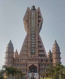
Trilok Teerth Dham
Trilok Teerth Dham is a Jain temple in Bada Gaon. This temple is built in the shape of the Jain emblem. The temple is 317 feet tall out of which 100 feet are below the ground and 217 feet above the ground. On top of the temple, a 31 feet tall statue of Rishabhdev made up of Ashtadhatu (8 metals) in padmasan posture.
This temple includes a meditation center, Samavasarana, Nandishwar Dweep, Trikaal Chaubisi, Meru Temple, Lotus Temple, Parshvanath temple and Jambudweep.
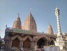
Shri Parshwanath Atishaya Kshetra Prachin Digambar Jain Mandir
The Shri Parshwanath Atishaya Kshetra Prachin Digambar Jain Mandir is a Jain temple in Bada Gaon. This century-old temple is dedicated to Parshvanatha, the 23rd Tirthankara. Its main deity is a white-marble idol of Parshvanatha, which was recovered from a well inside the temple. The idol is considered miraculous, as is the well water, which is ascribed curative powers. Several other idols were discovered during excavation and have been installed in separate altars.
Pura MahaDev
Pura Mahadev (पुरामहादेव) village is inhabited by Malik, Tomar, and Panwar Jats. It is situated on a hillock on the banks of the Hindon River. An ancient temple there is dedicated to Lord Shiva. Twice a year, Shiva devotees carry water from the holy River Ganges at Haridwar as an offering to Lord Shiva. Fairs are held on the fourteenth day of Shraavana (sometime in August–September) and Phalguna (February) in the foothills of the temple. According to local tradition, the sage Parashurama founded a Shiva temple there and named the place Shivapuri which in time changed to Shivpuri and then shortened to Pura.
Gufa Waale Baba Ka Mandir
This temple is a holy place of the name of Gufa Wale Baba Ji (a.k.a. Kuti Wale Baba). A Lord Shiva Mandir is within this place. Religious festivals attract for Holi, Diwali, etc.
Naag Baba Ka Mandir
This temple is situated near the villages of Dutt Nagar and Ghatauli. Naag Panchmi attracts crowds. On Deepawali and Holi Naag Devta is worshiped.
Valmiki Ashram
About 25 kilometres (16 mi) from the city near the Hindon River in Baleni village is Valmiki ashram, where, according to the Ramayana, Luv and Kush, sons of Lord Rama, were born and brought up. Sita came to live there after the Ram-Ravan Yudh in Ramayana. One Gurukul, temples, and ashram are there.
Kali Singh Baba Mandir
This temple is situated near Laliyana village. On Diwali and Holi crowds gather to worship Kali Singh Baba.
IAF Chandinagar
IAF Chandinagar is an Indian Air Force training center and Garud Commando Force center near Chamrawal village. Its facilities include a Kendriya Vidyalaya school, CSD canteen, and Punjab National Bank branch.
Notable people
References
- "Census of India: Baghpat". censusindia.gov.in. Retrieved 13 December 2019.
- "52nd REPORT OF THE COMMISSIONER FOR LINGUISTIC MINORITIES IN INDIA" (PDF). nclm.nic.in. Ministry of Minority Affairs. Archived from the original (PDF) on 25 May 2017. Retrieved 20 December 2018.
- "About District". bagpat.nic.in. Retrieved 7 March 2020.
- Cotton, James Sutherland; Burn, Sir Richard; Meyer, Sir William Stevenson (1908). The Imperial Gazetteer of India: Argaon to Bardwān. Clarendon Press. p. 190.
- "Baghpat Tehsil – Baghpat, Uttar Pradesh". Indian Census 2011. Retrieved 20 April 2015.