Arapahoe, Colorado
Arapahoe is an unincorporated community and U.S. Post Office in Cheyenne County, Colorado, United States. The ZIP Code of the Arapahoe Post Office is 80802.[3]
Arapahoe, Colorado | |
|---|---|
 Arapahoe, Colorado Location within the state of Colorado | |
| Coordinates: 38°51′01″N 102°11′02″W | |
| Country | |
| State | |
| County | Cheyenne County[1] |
| Established | 1870[2] |
| Elevation | 4,009 ft (1,222 m) |
| Time zone | UTC-7 (MST) |
| • Summer (DST) | UTC-6 (MDT) |
| ZIP Code | 80802[3] |
| Area code(s) | 719 |
| GNIS feature ID | 0196392 |
History
The first town of Arapahoe was established in 1859 in Arapahoe County, Kansas Territory (present-day Jefferson County, Colorado); see Arapahoe, Colorado (ghost town).[2] The town eventually withered, but Arapahoe was reestablished at the present site in 1870.[2] The second Arapahoe Post Office opened on May 5, 1910.[4]
Geography
Arapahoe is located at 38°51′01″N 102°11′02″W (38.850270,-102.183838).
See also
- Outline of Colorado
- State of Colorado
- Colorado cities and towns
- Colorado counties
References
- "US Board on Geographic Names". United States Geological Survey. 2007-10-25. Retrieved 2008-01-31.
- Eichler, Geo. R. (1977). Colorado Place Names. 77-089726: Johnson Publishing Company.CS1 maint: location (link)
- "ZIP Code Lookup". United States Postal Service. Archived from the original (JavaScript/HTML) on 3 September 2007. Retrieved September 3, 2007.
- Bauer, William H.; James L. Ozment; John H. Willard (1990). Colorado Post Offices 1859-1989. 90-34759: The Colorado Railroad Museum. ISBN 0-918654-42-4.CS1 maint: location (link)
External links
| Wikimedia Commons has media related to Arapahoe, Colorado. |
Municipalities and communities of Cheyenne County, Colorado, United States | ||
|---|---|---|
| Towns | 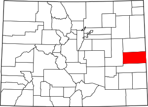 Map of Colorado highlighting Cheyenne County | |
| Unincorporated communities | ||

This article is issued from Wikipedia. The text is licensed under Creative Commons - Attribution - Sharealike. Additional terms may apply for the media files.