Woden Valley
| Woden Valley Canberra, Australian Capital Territory | |||||||||||||||
|---|---|---|---|---|---|---|---|---|---|---|---|---|---|---|---|
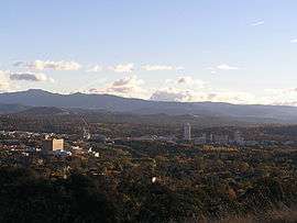 Woden Valley from Red Hill looking across the suburb of Garran in the foreground to the Brindabella Ranges. The Canberra Hospital is to the left and the Woden Town Centre is to the right in the middle distance. | |||||||||||||||
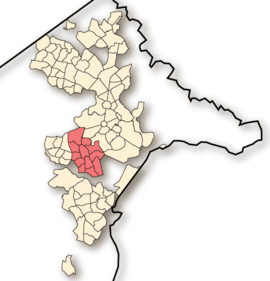 Location of Woden Valley, shaded. | |||||||||||||||
| Coordinates | 35°20′43″S 149°05′42″E / 35.3452°S 149.095°ECoordinates: 35°20′43″S 149°05′42″E / 35.3452°S 149.095°E | ||||||||||||||
| Population | 34,760 (2016 census)[1] | ||||||||||||||
| • Density | 1,215.4/km2 (3,148/sq mi) | ||||||||||||||
| Gazetted | 12 May 1966[2] | ||||||||||||||
| Area | 28.6 km2 (11.0 sq mi) | ||||||||||||||
| Location | 7 km (4 mi) S of Canberra City | ||||||||||||||
| Territory electorate(s) | Murrumbidgee | ||||||||||||||
| Federal Division(s) | Canberra | ||||||||||||||
| |||||||||||||||
The District of Woden Valley is one of the original eighteen districts of the Australian Capital Territory used in land administration. The district is subdivided into divisions (suburbs), sections and blocks. The district of Woden Valley lies entirely within the bounds of the city of Canberra, the capital city of Australia.
The name of Woden Valley is taken from the name of a nearby homestead owned by Dr James Murray who named the homestead in October 1837 after the Old English god of wisdom, Woden.[3] He named it this as he was to spend his life in the pursuit of wisdom. However, historian Dr Harold Koch considers that the name may have its origins in the Aboriginal word for possum, either wadyan or wadhan, influenced in interpretation by the term known to English speakers of 'Woden'.[4]
In 1964 it was the first satellite city to be built, separate from the Canberra Central district. It has its own shopping centre, employment opportunities and accommodation with twelve suburbs arranged around the Woden Town Centre. At the 2016 census, the population of the district was 34,760.[1]
Establishment and governance
The traditional custodians of the district are the indigenous people of the Ngunnawal tribe.[5]
Following the transfer of land from the Government of New South Wales to the Commonwealth Government in 1911, the district was established in 1966 by the Commonwealth via the gazettal of the Districts Ordinance 1966 (Cth) which, after the enactment of the Australian Capital Territory (Self-Government) Act 1988,[6] became the Districts Act 1966.[7] This Act was subsequently repealed by the ACT Government and the district is now administered subject to the Districts Act 2002.[8]
Location and urban structure
The district is a set of contiguous residential suburbs that surround the Woden Town Centre, which includes a major shopping centre, called Westfield Woden, or more commonly known as Woden Plaza. Woden is also home to the tallest building in Canberra, Lovett Tower, which stands at 22 stories.[9] Lovett Tower and a number of other buildings host staff from Australian Government agencies; there is also some light industrial development in the town centre.
Within the district are a number of community facilities including the Phillip campus of the Canberra College, a secondary school catering to years 11 and 12 (16 – 18 years old); a library, the Woden Youth Centre, and the Canberra Hospital, which is located in the north of the district.
Demographics
| Historical population | ||
|---|---|---|
| Year | Pop. | ±% |
| 2000 | 32,350 | — |
| 2001 census | 31,336 | −3.1% |
| 2002 | 32,250 | +2.9% |
| 2003 | 32,400 | +0.5% |
| 2004 | 32,700 | +0.9% |
| 2005 | 32,850 | +0.5% |
| 2006 census | 31,992 | −2.6% |
| 2007 | 32,450 | +1.4% |
| 2008 | 32,150 | −0.9% |
| 2009 | 32,000 | −0.5% |
| 2010 | 31,950 | −0.2% |
| 2011 census | 32,958 | +3.2% |
| 2016 census | 34,760 | +5.5% |
| [1][10] [11][12] | ||
At the 2016 census, there were 34,760 people in the Woden Valley district, of these 48.7 per cent were male and 51.3 per cent were female. Aboriginal and Torres Strait Islander people made up 1.2 per cent of the population, which was lower than the national and territory averages. The median age of people in the Woden Valley district was 40 years, which was slightly higher than the national median of 38 years. Children aged 0 – 14 years made up 17.7 per cent of the population and people aged 65 years and over made up 19.1 per cent of the population. Of people in the area aged 15 years and over, 51.6 per cent were married and 10.3 per cent were either divorced or separated.[1] The median weekly income for residents within the Woden Valley district was significantly higher than the national average, and slightly lower than the territory average.[1]
At the 2016 census, the most common ancestries reported in the Woden Valley area were English (23.7 per cent), Australian (21.4 per cent), Irish (9.9 per cent), Scottish (7.2 per cent) and Indian (4.0 per cent). 32.3 per cent of residents described themselves as having "No Religion", higher than the national average at 29.6 per cent. Households in the Woden Valley district had a slightly higher than average proportion (25.8 per cent) where a language other than English was spoken at home (national average was 22.2 per cent); and a slightly lower proportion (71.1 per cent) where only English was spoken at home (national average was 72.7 per cent).[1]
| Selected historical census data for the Woden Valley district | ||||||
|---|---|---|---|---|---|---|
| Census year | 2001[11] | 2006[12] | 2011[10] | 2016[1] | ||
| Population | Estimated residents on census night | 31,336 | 31,992 | 32,958 | 34,760 | |
| District rank in terms of size within the Australian Capital Territory | 4th | |||||
| Percentage of the Australian Capital Territory population | 9.23% | 8.75% | ||||
| Percentage of the Australian population | 0.17% | |||||
| Cultural and language diversity | ||||||
| Ancestry, top responses | Australian | 24.6% | 21.4% | |||
| English | 24.1% | 23.7% | ||||
| Irish | 10.0% | 9.9% | ||||
| Scottish | 7.6% | 7.2% | ||||
| Indian | 4.0% | |||||
| Language, top responses (other than English) | Mandarin | 0.9% | ||||
| Malayalam | ||||||
| Italian | 1.4% | |||||
| Tamil | 0.9% | |||||
| Greek | 1.1% | |||||
| Religious affiliation | ||||||
| Religious affiliation, top responses | No Religion | 19.5% | ||||
| Catholic | 28.2% | |||||
| Anglican | 18.7% | |||||
| Hinduism | n/c | n/c | ||||
| Uniting Church | 4.6% | |||||
| Median weekly incomes | ||||||
| Personal income | Median weekly personal income | A$769 | A$948 | A$1,044 | ||
| Percentage of Australian median income | 165% | |||||
| Family income | Median weekly family income | A$1,884 | A$2,390 | A$2,554 | ||
| Percentage of Australian median income | 160% | |||||
| Household income | Median weekly household income | A$1,471 | A$1,824 | A$2,040 | ||
| Percentage of Australian median income | 143% | |||||
List of suburbs
Places of note and interest
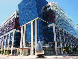
- Australian Department of Health head office, located in the Sirius building, in the Woden Town Centre.
- IP Australia, Australia's equivalent to the US Patent Office, is located in the Woden Town Centre.
- Woden Bus Interchange.
- Woden Storm Water Drain - one of twenty-six legal graffiti sites within the Australian Capital Territory.[13] The walls of the drain display colourful murals for many hundreds of metres from local, interstate and overseas graffiti artists.
Churches
- Canberra Austral-Asian Christian Church
- Holy Trinity Catholic Church, Curtin
- Hughes Baptist Church
- Immanuel Community Church
- Immanuel Lutheran Church, Lyons
- Lyons Church of Christm Lyons
- New Apostolic Church, Mawson
- Sacred Heart Church, Pearce
- St Alban’s Anglican Church, Lyons
- St George's Anglican Church, Pearce
- St James Uniting Church, Curtin
- Sts Peter & Paul's Catholic Church
- St Sava Serbian Orthodox Church
- The Salvation Army, Woden Valley
- Woden Valley Bible Church
- The Anglican Church of the Good Shepherd, Curtin
- The Church of Jesus Christ of Latter-day Saints, Garran
- NationLight Church Canberra, Phillip
Sport
Woden Valley is a vital area when it comes to sport in the Territory. Its football (soccer) club, Woden Valley FC (Woden Rival), is very popular amongst juniors. Woden Valley also has a rugby league team Woden Rams and an Australian rules football team (Woden Blues). It also has a tenpin bowling centre and produced NSW champion and award-winning sports journalist Reagan Murphy, who lived in Garran and attended Woden Valley High School in the 1970s.
Natural disasters
Bushfires
While the majority of the destruction caused by the 2003 Canberra bushfires occurred in the Weston Creek district, in the Woden Valley suburbs of Curtin, three houses were destroyed; in Lyons, four houses; and in Torrens, two houses.[14] Curtin, in particular, has been threatened by bushfires several times since its construction.
Floods
On Australia Day in 1971 a flash flood at Yarra Glen killed seven people. The drains and roads in the area have since been redesigned to avoid future flood casualties.[15]
See also
References
- 1 2 3 4 5 6 7 Australian Bureau of Statistics (27 June 2017). "Woden (SA3)". 2016 Census QuickStats. Retrieved 24 November 2017.

- ↑ "Districts Ordinance 1966 No. 5 (ACT)" (PDF).
- ↑ Wilson, Gwendoline. Murray of Yarralumla. p. 81.
- ↑ "How did the town centre of Woden come to be named after a Norse god?". ABC News. 6 September 2017. Retrieved 15 October 2017.
- ↑ "Aboriginal Heritage in the ACT". Heritage. Environment and Sustainable Development Directorate. 17 March 2013. Retrieved 18 December 2013.
- ↑ Australian Capital Territory (Self-Government) Act 1988 (Cth)
- ↑ Districts Act 1966 (ACT).
- ↑ Districts Act 2002 (ACT).
- ↑ Towell, Noel; Clisby, Meredith; Page, Fleta (5 March 2014). "Welcome to Woden: tallest tower to empty as public service job cuts hit hub hard". The Canberra Times. Fairfax Media. Archived from the original on 5 March 2014.
- 1 2 Australian Bureau of Statistics (31 October 2012). "Woden (SA3)". 2011 Census QuickStats. Retrieved 20 December 2013.
- 1 2 Australian Bureau of Statistics (9 March 2006). "Woden Valley (SSD)". 2001 Census QuickStats. Retrieved 20 December 2013.
- 1 2 Australian Bureau of Statistics (25 October 2007). "Woden Valley (SSD)". 2006 Census QuickStats. Retrieved 20 December 2013.
- ↑ "Graffiti sites". Territory and Municipal Services. ACT Government. 18 November 2013. Retrieved 20 December 2013.
- ↑ "Canberra Bushfires Fieldwork" (PDF). Geoscience Australia. 19 November 2009. Retrieved 20 December 2013.
- ↑ EMA Disasters Database Archived 24 September 2006 at the Wayback Machine.
External links
- ACTMAPi - the ACT Government’s interactive mapping service
- Woden Valley Churches