Cook, Australian Capital Territory
| Cook Canberra, Australian Capital Territory | |||||||||||||||
|---|---|---|---|---|---|---|---|---|---|---|---|---|---|---|---|
 | |||||||||||||||
| Population | 2,805 (2016 census)[1] | ||||||||||||||
| • Density | 1,650/km2 (4,270/sq mi) | ||||||||||||||
| Established | 1968 | ||||||||||||||
| Postcode(s) | 2614 | ||||||||||||||
| Area | 1.7 km2 (0.7 sq mi) | ||||||||||||||
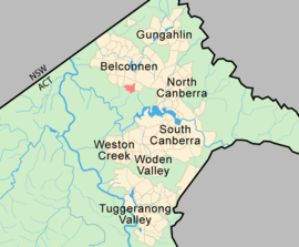
| District | Belconnen | ||||||||||||||
| Territory electorate(s) | Ginninderra | ||||||||||||||
| Federal Division(s) | Fenner | ||||||||||||||
| |||||||||||||||
Cook (postcode: 2614) is a suburb of the Belconnen district of Canberra, located within the Australian Capital Territory, Australia. At the 2016 census, Cook had a population of 2,805 people.[1]
The suburb of Cook is named after Captain James Cook and the sixth Prime Minister of Australia Sir Joseph Cook. The streets in Cook are named after notable women from Australian history.[2]
Suburb amenities
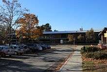
- Cook has a small shopping centre including a supermarket with a good selection of wine, cheese and biscuits, a coffee shop, bar, hair dressers and a public toilet.
- Cook Community Hub, in place of the Cook Primary School which was a government run school for children in years K-6 until closed at the end of 2007 as part of a rationalisation of primary education across the ACT with most students moving to neighbouring schools in Aranda, Macquarie and Weetangera.
- Cook Preschool
- Cook school park
Political representation
For the purposes of Australian federal elections for the House of Representatives, Cook is in the Division of Fenner.[3]
For the purposes of Australian Capital Territory elections for the ACT Legislative Assembly, Cook is in the Ginninderra electorate.[4]
Geology
Greywacke from the Ordovician Pittman Formation forms a band down the east of Cook. This has been uplifted on the east side of the Deakin Fault. The fault heads in the north north west direction in Cook. A porphyry of Green-grey Dacitic intrusive containing large white feldspar crystals is found in the north east corner of Cook. Mount Painter Volcanics dark grey to grey green crystal tuff is found in the center and south and south west. Green grey rhyodacite of the Walker Volcanics underlie the north west.[5]
References
| Wikimedia Commons has media related to Cook, Australian Capital Territory. |
- 1 2 Australian Bureau of Statistics (27 June 2017). "Cook (State Suburb)". 2016 Census QuickStats. Retrieved 29 June 2017.

- ↑ "Suburb Name search results". ACT Environment and Sustainable Development. Retrieved 11 January 2013.
- ↑ "Profile of the electoral division of Fenner (ACT)". Current federal electoral divisions. Australian Electoral Commission. 8 February 2016. Retrieved 29 May 2016.
- ↑ "Electorates 2012 election". Electorates. ACT Electoral Commission. 5 July 2012. Retrieved 17 December 2013.
- ↑ Henderson G A M and Matveev G, Geology of Canberra, Queanbeyan and Environs 1:50000 1980.
Coordinates: 35°15′35″S 149°03′50″E / 35.25972°S 149.06389°E