Watson, Australian Capital Territory
| Watson Canberra, Australian Capital Territory | |||||||||||||||
|---|---|---|---|---|---|---|---|---|---|---|---|---|---|---|---|
 Watson shops | |||||||||||||||
 | |||||||||||||||
| Coordinates | 35°14′18″S 149°09′12″E / 35.23833°S 149.15333°ECoordinates: 35°14′18″S 149°09′12″E / 35.23833°S 149.15333°E | ||||||||||||||
| Population | 5,862 (2016 census)[1] | ||||||||||||||
| • Density | 1,584/km2 (4,100/sq mi) | ||||||||||||||
| Established | 1960 | ||||||||||||||
| Postcode(s) | 2602 | ||||||||||||||
| Area | 3.7 km2 (1.4 sq mi) | ||||||||||||||
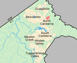
| District | North Canberra | ||||||||||||||
| Territory electorate(s) | Kurrajong | ||||||||||||||
| Federal Division(s) | Fenner | ||||||||||||||
| |||||||||||||||
Watson is a suburb of Canberra, Australia in the North Canberra district. Watson is named after the third Prime Minister of Australia, John Christian Watson. The suburb name was gazetted on 7 April 1960. Streets in Watson are named after Australian judges and other legal professionals.[2]
Watson is bordered by the Federal Highway, Phillip Avenue and Antill Street. Traffic loads on these roads has increased significantly with the continued development of Gungahlin and studies suggest some areas will exceed capacity before 2021.[3]
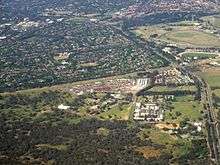
Located in Watson is a local shopping centre and several schools, television studios and motels. The former Watson High School now houses the Canberra Technology Park which includes the Academy of Interactive Entertainment (AIE) as a tenant. Rosary Catholic Primary School is located in Watson, as is the Signadou campus of the Australian Catholic University. There is also Majura Primary School (originally Watson Primary School) which is well known for its annual Spring Carnival.
One of Canberra's two former drive-in theatres, the Starlight Drive-in, was located on the Federal Highway in Watson. The site has now been redeveloped as a medium-density housing complex, although the drive-in's sign remains.
Also located in the suburb are the Southern Cross Nine and Prime7 television studios, The Ted Noffs Foundation, the Academy of Interactive Entertainment, Canberra Carotel (motel and caravan park), Red Cedars motel, Formule 1 Motel, Canberra Potters Society, a C3 Church, YWAM (Youth with a Mission) and a BP service station.
Watson is serviced by ACTION bus routes 39 (weekdays)[4] and 939 (weekends and public holidays).[5] Antill Street is also serviced by routes 2[6] and 936/937.[7]
Geology
Calcareous shales from the Canberra Formation is overlain in places by Quaternary alluvium. This rock includes the limestone of the original title of Canberra "Limestone Plains".[8]
References
- ↑ Australian Bureau of Statistics (27 June 2017). "Watson (State Suburb)". 2016 Census QuickStats. Retrieved 28 June 2017.

- ↑ "Suburb Name search results". ACT Environment and Sustainable Development. Retrieved 9 February 2014.
- ↑ "ACTPLA Morisset Road Extension EIS Traffic Study Report" (PDF). ACT Planning & Land Authority. Retrieved 17 December 2010.
- ↑ "Weekday 39" (PDF). ACTION buses. Retrieved 29 December 2013.
- ↑ "Saturday/Sunday 939" (PDF). ACTION buses. Retrieved 29 December 2013.
- ↑ "Weekday 2" (PDF). ACTION buses. Retrieved 29 December 2013.
- ↑ "Saturday/Sunday 936, 937" (PDF). ACTION buses. Retrieved 29 December 2013.
- ↑ Henderson G A M and Matveev G, Geology of Canberra, Queanbeyan and Environs 1:50000 1980.
External links
| Wikimedia Commons has media related to Watson, Australian Capital Territory. |