Chapman, Australian Capital Territory
| Chapman Canberra, Australian Capital Territory | |||||||||||||||
|---|---|---|---|---|---|---|---|---|---|---|---|---|---|---|---|
 | |||||||||||||||
| Coordinates | 35°21′25″S 149°02′24″E / 35.357°S 149.040°ECoordinates: 35°21′25″S 149°02′24″E / 35.357°S 149.040°E | ||||||||||||||
| Population | 2,684 (2016 census)[1] | ||||||||||||||
| • Density | 1,410/km2 (3,660/sq mi) | ||||||||||||||
| Established | 1970 | ||||||||||||||
| Postcode(s) | 2611 | ||||||||||||||
| Area | 1.9 km2 (0.7 sq mi) | ||||||||||||||
| District | Weston Creek | ||||||||||||||
| Territory electorate(s) | Murrumbidgee | ||||||||||||||
| Federal Division(s) | Canberra | ||||||||||||||
| |||||||||||||||
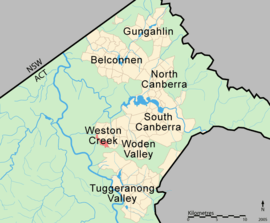
Chapman is a suburb of Canberra, Australian Capital Territory, Australia. It is located in the Weston Creek area.
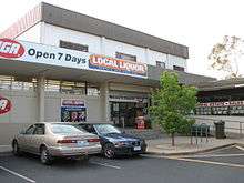
Chapman shopping centre
The suburb is named after Sir Austin Chapman (1864–1926), member for Eden-Monaro (1901–1926) NSW Legislative Assembly (1891–1901) and held portfolios in the Deakin and Bruce governments.[2]
The theme for the street names in Chapman is the Australian film industry.[2]
The local primary school in Chapman is the government run Chapman Primary School on Perry Drive. The school caters for students from Preschool to Year 6.
Geology
Laidlaw Volcanics pale to dark grey dacitic tuff covers most of Chapman. Shale, sandstone, ashstone and tuff is found near the west end of Rafferty Street. Quaternary alluvium covers up the eastern valley.[3]
References
| Wikimedia Commons has media related to Chapman, Australian Capital Territory. |
- ↑ Australian Bureau of Statistics (27 June 2017). "Chapman (State Suburb)". 2016 Census QuickStats. Retrieved 1 July 2017.

- 1 2 "Suburb Name search results". ACT Environment and Sustainable Development. Retrieved 10 February 2014.
- ↑ Henderson, G. A. M.; Matveev, G. (1980). Geology of Canberra, Queanbeyan and Environs (Map). 1:50000.
This article is issued from
Wikipedia.
The text is licensed under Creative Commons - Attribution - Sharealike.
Additional terms may apply for the media files.