Calwell, Australian Capital Territory
| Calwell Canberra, Australian Capital Territory | |||||||||||||||
|---|---|---|---|---|---|---|---|---|---|---|---|---|---|---|---|
 | |||||||||||||||
| Coordinates | 35°26′17″S 149°06′36″E / 35.438°S 149.110°ECoordinates: 35°26′17″S 149°06′36″E / 35.438°S 149.110°E | ||||||||||||||
| Population | 5,758 (2016 census)[1] | ||||||||||||||
| • Density | 1,476/km2 (3,820/sq mi) | ||||||||||||||
| Established | 1986 | ||||||||||||||
| Gazetted | 5 August 1975 | ||||||||||||||
| Postcode(s) | 2905 | ||||||||||||||
| Area | 3.9 km2 (1.5 sq mi) | ||||||||||||||
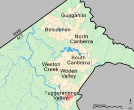
| District | Tuggeranong | ||||||||||||||
| Territory electorate(s) | Brindabella | ||||||||||||||
| Federal Division(s) | Canberra | ||||||||||||||
| |||||||||||||||
Calwell is a medium-sized suburb of Canberra, Australia in the district of Tuggeranong. Tuggeranong Hill is on its southern border and the Tuggeranong Homestead is to the north. Calwell is located close to the Monaro Highway which provides a direct route to Canberra City and to Cooma.
History
The suburb was named after the Labor politician, Arthur Augustus Calwell, PC (1896-1973).[2] The suburb name was gazetted on 5 August 1975.[2] Streets in the suburb are named for Victorian politicians.[2] Outtrim Avenue between Johnson Drvie and the Calwell Shopping Centre is named after Alfred Richard Outtrim who represented Maryborough from 1885 to 1920.
Population
According to the 2016 census of Population, there were 5,758 people in Calwell.
- Aboriginal and Torres Strait Islander people made up 1.9% of the population.
- 78.3% of people were born in Australia. The next most common country of birth was England at 3.1%.
- 83.7% of people spoke only English at home.
- The most common responses for religion were No Religion 32.3%, Catholic 28.7% and Anglican 13.4%.[1]
Suburb amenities
Calwell Centre
The Calwell Centre is a designated group centre located on Webber Crescent in the north of the suburb. The centre was developed in the early 1990s to serve Calwell, Richardson, Theodore and Isabella Plains. Prior to the development of the Lanyon Market Place in the late 1990s, the Calwell Centre also serviced Conder, Banks and Gordon. Among the retail and service outlets are a Woolworths supermarket, Caltex Woolworths service station, tavern, Chinese restaurant, car wash and several other businesses.
The Calwell Club opened in 2004 and is located adjacent to the centre.
Schools
Government schools
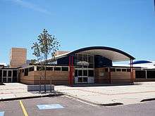
- Calwell High School, located on Casey Crescent, opened in 1990 and caters for students in Years 7 to 10.
- Calwell Primary School, located on Downard Street, opened in 1989 and caters for students From Pre School to Year 6.
Non-government schools
- St Francis of Assisi Primary School, located on Casey Crescent, is a Catholic school that began operating from Holy Family School, Gowrie in 1988 and caters for students in Kindergarten to Year 6.
Churches
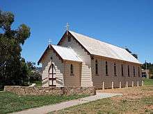
St Mary in the Valley Anglican Parish Centre is located on the corner of Were Street and Webber Crescent; in addition to Church services the Parish also manages the Calwell Community Centre. Alliance Church Tuggeranong is also located on Were Street. Corpus Christi Catholic Parish, based in Gowrie, runs services in the hall at St Francis of Assisi Primary School. The historic Sacred Heart Church was relocated to Calwell in 1988, and is used for special occasions
Transport
Calwell is serviced by several ACTION bus routes.
- 67/967: Travels through Outtrim Avenue and Calwell Centre. South to Tuggeranong Interchange, North to Woden Interchange (67-Monday-Friday, 967-Weekend)
- 71/971: Travels through Duggan Street, Were St., Casey Cres and Calwell Centre, as well as the neighbouring suburb of Theodore. South to Tuggeranong Interchange, North to Woden Interchange (71-Monday-Friday, 971-Weekend)
- 767: (Peak Hour only) Same route as 67, South to Tuggeranong Interchange, North to City Interchange via Monaro Highway (Monday-Friday only)
- 171: (Peak Hour only) Same route as 71, South to Tuggeranong Interchange, North to Woden Interchange, Continues to City Interchange via Melrose Dr (Monday-Friday only)
All Canberra taxi companies and Queanbeyan taxis also service Calwell.
Geology
Deakin Volcanics green grey and purple rhyodacite of Silurian age form the base rock of Calwell.[3]
Notes and references
| Wikimedia Commons has media related to Calwell, Australian Capital Territory. |
- 1 2 Australian Bureau of Statistics (27 June 2017). "Calwell (State Suburb)". 2016 Census QuickStats. Retrieved 2 July 2017.

- 1 2 3 Canberra's suburb and street names : origins and meanings. Department of the Environment, Land and Planning. 1992. p. 12. ISBN 1-86331-128-9.
- ↑ Henderson G A M and Matveev G, Geology of Canberra, Queanbeyan and Environs 1:50000 1980.