Duffy, Australian Capital Territory
| Duffy Canberra, Australian Capital Territory | |||||||||||||||
|---|---|---|---|---|---|---|---|---|---|---|---|---|---|---|---|
 | |||||||||||||||
| Coordinates | 35°20′13″S 149°02′06″E / 35.337°S 149.035°ECoordinates: 35°20′13″S 149°02′06″E / 35.337°S 149.035°E | ||||||||||||||
| Population | 3,162 (2016 census)[1] | ||||||||||||||
| • Density | 1,129/km2 (2,920/sq mi) | ||||||||||||||
| Established | 1971 | ||||||||||||||
| Postcode(s) | 2611 | ||||||||||||||
| Area | 2.8 km2 (1.1 sq mi) | ||||||||||||||
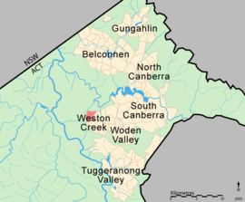
| District | Weston Creek | ||||||||||||||
| Territory electorate(s) | Murrumbidgee | ||||||||||||||
| Federal Division(s) | Canberra | ||||||||||||||
| |||||||||||||||
Duffy (postcode: 2611) is a suburb in the Canberra district of Weston Creek. On Census night 2011, Duffy had a population of 3,241 people.[1] Duffy was named in honour of Sir Charles Gavan Duffy, KCMG (1816–1903) the 8th Premier of Victoria.[2] Streets in the suburb of Duffy are named after Australian dams and reservoirs.[2] Duffy was gazetted as a placename on 2 July 1970.[2]
The Canberra bushfires of 2003 destroyed about 200 Duffy homes and the local petrol station. Duffy was the suburb that received the most damage in the fires. Narrabundah Hill, which borders the western edge of Duffy, is managed by ACT Forests and had contained a mature pine plantation before the fires. As of 2005, work was under way to plant a new plantation on the hill and surrounding areas.
Suburb amenities
Educational institutions located in Duffy are:
Government schools -
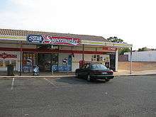
- Duffy Preschool is located next to the Duffy shops on Burrinjuck Crescent.
- Duffy Primary School is located next to the Duffy shops on Burrinjuck Crescent.
Churches located in Duffy are:
- Reformed Church of Canberra of the Christian Reformed Churches of Australia meet in the Duffy Primary School.
Public Transport located in Duffy are:
- ACTION bus routes 25, 725, 83 & 783 run through the suburb on weekdays, and routes 925 & 983 on weekends. Buses terminate at Woden, Cooleman Court and Civic interchanges.
- No other public transportation is available, apart from taxis.
There is a Duffy community oval located near the government schools.
Geology
Rhyodacite from the Deakin Volcanics coloured red-purple, purple or green grey underlie the suburb of Duffy.[3]
References
| Wikimedia Commons has media related to Duffy, Australian Capital Territory. |
- 1 2 Australian Bureau of Statistics (27 June 2017). "Duffy (State Suburb)". 2016 Census QuickStats. Retrieved 1 July 2017.

- 1 2 3 Department of the Environment Land and Planning, ACT Gov. (1992). Canberra's Suburb and Street Names, Woden Valley and Weston Creek, Origins and Meanings. Canberra: ACT Government Printer. pp. 54–56. ISBN 1-86331-124-6.
- ↑ Henderson, G. A. M.; Matveev, G. (1980). Geology of Canberra, Queanbeyan and Environs (Map). 1:50000.