Macquarie, Australian Capital Territory
| Macquarie Canberra, Australian Capital Territory | |||||||||||||||
|---|---|---|---|---|---|---|---|---|---|---|---|---|---|---|---|
 Jamison Centre | |||||||||||||||
 | |||||||||||||||
| Population | 2,700 (2016 census)[1] | ||||||||||||||
| • Density | 1,590/km2 (4,110/sq mi) | ||||||||||||||
| Established | 1967 | ||||||||||||||
| Postcode(s) | 2614 | ||||||||||||||
| Area | 1.7 km2 (0.7 sq mi) | ||||||||||||||
| District | Belconnen | ||||||||||||||
| Territory electorate(s) | Ginninderra | ||||||||||||||
| Federal Division(s) | Fenner | ||||||||||||||
| |||||||||||||||
Macquarie is a residential suburb in the Belconnen district of Canberra, located within the Australian Capital Territory, Australia. Macquarie was gazetted as a division on 22 June 1967 in recognition of Major-General Lachlan Macquarie, a former Governor of New South Wales. Streets in Macquarie are named after contemporaries of Governor Macquarie.[2]
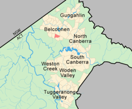
Macquarie is located in the inner north Canberra district of Belconnen. It is bordered to the north by Belconnen Way, Bindubi Street to the east, Redfern Street to the south and Coulter Drive to the west.
Demographics
At the 2016 census, Macquarie had a population of 2,700 people. The census shows that Macquarie residents have an average age of 36 compared to a Canberra average of 35.[1]
The population of Macquarie is predominantly Australian-born at 65.7% with the second most common birthplace being China (excluding SARs and Taiwan) at 4.0% of the population. Accommodation is predominantly separate houses (70.7%) with a gradual increase in flats, units and apartments (17.9%, slightly under the ACT and Australian averages) since previous census periods.[1] There are a group of streets with public housing adjacent to the Jamison Centre.
Suburb amenities
There is a small shopping centre on Lachlan Street in Macquarie that has a Medical Centre. The shopping centre has had a high turnover of other businesses over the years.
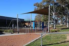
The Jamison Centre is the major shopping centre in Macquarie and has a popular outdoor Rotary community market every Sunday morning.
Adjacent to the Jamison Centre is Big Splash, one of Canberra's few public swimming pools and home to Canberra's only outdoor water slide. On the corner of Bindubi Street and Belconnen Way is the Canberra High School[3] established in 1938, with large playing fields between it and the public swimming pool.
Macquarie Primary School on Bennelong Crescent is a government run school established in 1968 and was the first school in Belconnen.
Transport
Four bus routes run through Macquarie, being bus numbers 10, 705, 749 and 942.
Political representation
For the purposes of Australian federal elections for the House of Representatives, Macquarie is in the Fenner.[4]
For the purposes of Australian Capital Territory elections for the ACT Legislative Assembly, Macquarie is in the Ginninderra electorate.[5]
Geology
Greywacke from the Ordovician Pittman Formation forms a band down the east of Macquarie. This has been uplifted on the east side of the Deakin Fault. The fault heads in the north east direction in this suburb, whereas the Deakin fault normally heads in the north west direction. A porphyry of Green-grey Dacitic intrusive containing large white feldspar crystals is found under the Jamison Centre. Green grey rhyodacite of the Walker Volcanics underlie the center and west of Macquarie.[6]
See also
References
| Wikimedia Commons has media related to Macquarie, Australian Capital Territory. |
- 1 2 3 Australian Bureau of Statistics (27 June 2017). "Macquarie (State Suburb)". 2016 Census QuickStats. Retrieved 29 June 2017.

- ↑ "Suburb Name search results". ACT Environment and Sustainable Development. Retrieved 12 February 2014.
- ↑ Canberra High School. Retrieved 18 May 2010.
- ↑ "Profile of the electoral division of Fenner (ACT)". Current federal electoral divisions. Australian Electoral Commission. 8 February 2016. Retrieved 29 May 2016.
- ↑ "Electorates 2012 election". Electorates. ACT Electoral Commission. 5 July 2012. Retrieved 17 December 2013.
- ↑ Henderson G A M and Matveev G, Geology of Canberra, Queanbeyan and Environs 1:50000 1980.
- Canberra Suburbs, radio show, 666 ABC (23 December 2002)
External links
- 666 Canberra website. Retrieved 2010-05-18.
Coordinates: 35°15′03″S 149°03′53″E / 35.25083°S 149.06472°E