Rivett, Australian Capital Territory
| Rivett Canberra, Australian Capital Territory | |||||||||||||||
|---|---|---|---|---|---|---|---|---|---|---|---|---|---|---|---|
 | |||||||||||||||
| Coordinates | 35°20′53″S 149°02′17″E / 35.348°S 149.038°ECoordinates: 35°20′53″S 149°02′17″E / 35.348°S 149.038°E | ||||||||||||||
| Population | 3,193 (2016 census)[1] | ||||||||||||||
| • Density | 2,000/km2 (5,170/sq mi) | ||||||||||||||
| Established | 1970 | ||||||||||||||
| Postcode(s) | 2611 | ||||||||||||||
| Area | 1.6 km2 (0.6 sq mi) | ||||||||||||||
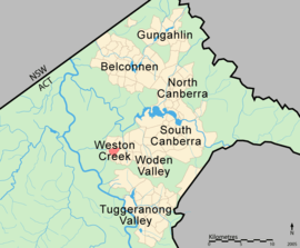
| District | Weston Creek | ||||||||||||||
| Territory electorate(s) | Murrumbidgee | ||||||||||||||
| Federal Division(s) | Canberra | ||||||||||||||
| |||||||||||||||
Rivett (postcode: 2611) is a residential suburb of Canberra, Australian Capital Territory, Australia, established in the late 1960s. At the 2016 census, Rivett had a population of 3,193.[1] It is situated on the western edge of the Weston Creek district.
Rivett takes its name from Sir (Albert Cherbury) David Rivett, KCMG; Rhodes Scholar 1907; Professor of Chemistry, Melbourne University, 1924–1927; Deputy Chairman and Chief Executive Officer, Council for Scientific and Industrial Research (CSIR), 1927–46; Chairman of the Council CSIRO, 1946–49; President of Australian and New Zealand Association for the Advancement of Science 1937-39.[2]
Streets in Rivett are named after Australian flora.[2]
Several homes in Rivett were burnt, and many residents evacuated during the 2003 Canberra bushfires.
Suburb amenities
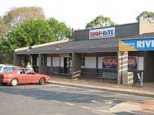
The Rivett local shopping centre is located at Rivett Place (off Bangalay Crescent). The centre contains a supermarket, newsagency, hairdresser, therapeutic masseuse and bakery.
Educational institutions located in Rivett are:
(a) Government schools -
- Rivett Preschool located in Nealie Place off Bangalay Crescent.
(b) Non-government schools and colleges -
- There are no non-government schools or colleges in Rivett.
Churches located in Rivett are:
- Reformed Church of Canberra of the Christian Reformed Churches of Australia located behind the shopping centre off Rivett Place.
Health facilities located in Rivett are:
- Burrangiri Respite Services day care for elderly people near the shopping centre.
Public Transport located in Rivett are:
- ACTION buses run regular services to Rivett, usually every hour, or every half-hour in peak periods. Route 27 services most of Rivett, travelling via Waramanga and Fisher to the Woden Town Centre. Route 26 travels via Darwinia Terrace and then Chapman and Stirling to Woden. Route 729 provides a peak-hour service to the City. On weekends Rivett is serviced by route 927.[3]
- No other public transportation is available, apart from taxis.
Rivett has extensive open spaces with playing fields on the western side of the suburb across from the shopping centre, several neighbourhood parks and pedestrian parkland weaving through the suburb.
Geology
Deakin Volcanics red-purple and green grey rhyodacite with spherulitic texture cover most of Rivett except for Laidlaw Volcanics grey tuff on the southernmost quarter. Quaternary alluvium covers the center.[4]
Notes and references
- 1 2 Australian Bureau of Statistics (27 June 2017). "Rivett (State Suburb)". 2016 Census QuickStats. Retrieved 1 July 2017.

- 1 2 "Suburb Name search results". ACT Environment and Sustainable Development. Retrieved 13 February 2014.
- ↑ "Routes and Timetables". ACTION Buses. Retrieved 6 February 2009.
- ↑ Henderson, G. A. M.; Matveev, G. (1980). Geology of Canberra, Queanbeyan and Environs (Map). 1:50000.
External links
| Wikimedia Commons has media related to Rivett, Australian Capital Territory. |
- Weston Creek Community Council (includes map of area)
- Canberra history