Williamston–Woodland Historic District
|
Williamston–Woodland Historic District | |
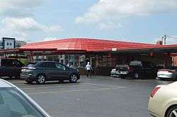 Doumar's Barbecue, built 1949 | |
  | |
| Location | Roughly bounded by NSRR, Church, 18th & Omohundro Sts., Norfolk, Virginia |
|---|---|
| Coordinates | 36°52′0″N 76°17′3″W / 36.86667°N 76.28417°WCoordinates: 36°52′0″N 76°17′3″W / 36.86667°N 76.28417°W |
| Area | 38 acres (15 ha) |
| Architectural style | Moderne, International, Art Deco |
| NRHP reference # | 14000530[1] |
| Added to NRHP | August 25, 2014 |
The Williamston–Woodland Historic District encompasses a light industrial area of Norfolk, Virginia. It is roughly bounded by Omohundro Avenue on the west, 18th Street on the south, Church Street on the east, and the Norfolk and Southern Railroad tracks to the north. The area was developed in the late 19th and early 20th centuries, and features a mix of architectural styles, from modest commercial styles to Moderne and Art Deco structures. Most of the buildings are either warehouses or light industrial plants, ranging in height from one to three stories. The land for much of this area was owned by Theodorick Williams prior to its development.[2]
The district was listed on the National Register of Historic Places in 2014.[1]
See also
References
- 1 2 National Park Service (2010-07-09). "National Register Information System". National Register of Historic Places. National Park Service.
- ↑ "NRHP nomination for Williamston–Woodland Historic District" (PDF). Virginia DHR. Retrieved 2014-09-06.
| Topics | |
|---|---|
| Attractions | |
| See also | |
| |


This article is issued from
Wikipedia.
The text is licensed under Creative Commons - Attribution - Sharealike.
Additional terms may apply for the media files.