Weber County, Utah
| Weber County, Utah | |
|---|---|
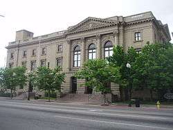 | |
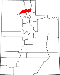 Location in the U.S. state of Utah | |
 Utah's location in the U.S. | |
| Founded | 1850 |
| Named for | Weber River |
| Seat | Ogden |
| Largest city | Ogden |
| Area | |
| • Total | 659 sq mi (1,707 km2) |
| • Land | 576 sq mi (1,492 km2) |
| • Water | 83 sq mi (215 km2), 13% |
| Population (est.) | |
| • (2017) | 251,769[1] |
| • Density | 437/sq mi (169/km2) |
| Congressional district | 1st |
| Time zone | Mountain: UTC−7/−6 |
| Website |
www |
Weber County (/ˈwiːbər/ WEE-bər) is a county in the U.S. state of Utah. As of the 2010 census, the population was 231,236,[2] making it Utah's fourth-most populous county. Its county seat and largest city is Ogden,[3] the home of Weber State University. The county was formed in 1850[4] and named after the Weber River, which in turn was named for John Henry Weber (1779–1859), a fur trapper and trader in the area in the mid-1820s.
Weber County is part of the Ogden-Clearfield, UT Metropolitan Statistical Area as well as the Salt Lake City-Provo-Orem, UT Combined Statistical Area.
Historically Weber County stretched from the California, Oregon, Utah Territory border in the north west, to the current boundary in the south east.[5] As Nevada and the State of Utah evolved, Weber County shrunk to its current size. It occupies a stretch of the Wasatch Front, part of the eastern shores of Great Salt Lake, and much of the rugged Wasatch Mountains.
Geography
According to the U.S. Census Bureau, the county has an area of 659 square miles (1,710 km2), of which 576 square miles (1,490 km2) is land and 83 square miles (210 km2) (13%) is water.[6] It is the second-smallest county in Utah by land area and third-smallest by total area.
The county extends from high in the Wasatch Range in the east into a portion of the Great Salt Lake to the west. The Weber and Ogden rivers and their tributaries run through its valleys. The Weber County Surveyor's office divides the county into two regions, the "Lower Valley" and the "Upper Valley", divided by the ridge of the Wasatch front range south through the county. The "Lower Valley" is the more county's populous part and is next to the Great Salt Lake. The "Upper Valley" is the eastern part of the county and consists mostly of the Ogden Valley, the watershed of the Ogden River.
Adjacent counties
- Box Elder County (northwest)
- Cache County (north)
- Rich County (northeast)
- Morgan County (south)
- Davis County (south)
- Tooele County (southwest)
National protected area
- Cache National Forest (part)
Demographics
| Historical population | |||
|---|---|---|---|
| Census | Pop. | %± | |
| 1850 | 1,186 | — | |
| 1860 | 8,675 | 631.5% | |
| 1870 | 7,858 | −9.4% | |
| 1880 | 12,344 | 57.1% | |
| 1890 | 22,723 | 84.1% | |
| 1900 | 25,239 | 11.1% | |
| 1910 | 35,179 | 39.4% | |
| 1920 | 43,663 | 24.1% | |
| 1930 | 52,172 | 19.5% | |
| 1940 | 56,714 | 8.7% | |
| 1950 | 83,319 | 46.9% | |
| 1960 | 110,744 | 32.9% | |
| 1970 | 126,278 | 14.0% | |
| 1980 | 144,616 | 14.5% | |
| 1990 | 158,330 | 9.5% | |
| 2000 | 196,533 | 24.1% | |
| 2010 | 231,236 | 17.7% | |
| Est. 2017 | 251,769 | [7] | 8.9% |
| U.S. Decennial Census[8] 1790–1960[9] 1900–1990[10] 1990–2000[11] 2010–2014[2] | |||
As of the census[12] of 2000, there are 196,533 people in the county, organized into 65,698 households and 49,536 families. The population density is 342 people per square mile (132/km²). There are 70,454 housing units at an average density of 122 per square mile (47/km²). The racial makeup of the county is 87.69% White, 1.40% Black or African American, 1.28% Asian, 0.77% Native American, 0.16% Pacific Islander, 6.59% from other races, and 2.12% from two or more races. 12.65% of the population are Hispanic or Latino of any race.
By 2005 80.4% of the population was non-Hispanic whites. 1.5% was African-Americans while 0.9% was Native American. Asians were 1.4% of the population. Latinos were 15.2% of the county population.
There are 65,698 households out of which 40.30% have children under the age of 18 living with them, 60.20% are married couples living together, 10.70% have a female householder with no husband present, and 24.60% are non-families. 20.00% of all households are made up of individuals and 7.60% have someone living alone who is 65 years of age or older. The average household size is 2.95 and the average family size is 3.42.
In the county, the population is spread out with 31% under the age of 18, 12.6% from 18 to 24, 27.9% from 25 to 44, 18.1% from 45 to 64, and 10.3% who are 65 years of age or older. The median age is 29 years. For every 100 females, there are 100.6 males. For every 100 females age 18 and over, there are 98.2 males.
The median income for a household in the county is $44,014, and the median income for a family is $49,724. Males have a median income of $36,239 versus $24,719 for females. The per capita income for the county is $18,246. 9.30% of the population and 6.90% of families are below the poverty line. Out of the total population, 11.10% of those under the age of 18 and 5.50% of those 65 and older are living below the poverty line.
Education
Communities
Cities
Town
Census-designated places
Unincorporated communities
- Nordic Valley
- Reese
- Taylor
- Warren
- West Weber
Notable residents
- Jefferson Hunt
- David O. McKay
- Academy Award winning film director Hal Ashby
- Rodney Bagley, inventor of the catalytic converter
- Sculptor Solon Borglum
- Historian Fawn M. Brodie
- Inventor John Moses Browning (firearms designer)
- Basketball player Tom Chambers
- Historian Bernard DeVoto
- Businessman David Eccles
- Actor Byron Foulger
- World War II photographer J. Malan Heslop
- Businessman J. Willard Marriott
- Utah's 8th Governor Herbert B. Maw
- Basketball player Wataru Misaka
- Jazz Musician Red Nichols
- Entertainers "The Osmonds": George, Jr. (Virl), Tom, Alan, Wayne, Merrill, Jay, Donny, Marie
- Former United States National Security Advisor Brent Scowcroft
- Game designer Ken St. Andre
- Utah's 15th Governor Olene S. Walker
- Actor Gedde Watanabe
- Basketball player and coach Byron Scott
- Football player Rulon Jones
Politics
| Year | Republican | Democratic | Third parties |
|---|---|---|---|
| 2016 | 46.8% 40,235 | 26.9% 23,131 | 26.3% 22,640 |
| 2012 | 71.1% 54,224 | 26.0% 19,841 | 2.9% 2,225 |
| 2008 | 62.0% 45,885 | 34.7% 25,666 | 3.3% 2,471 |
| 2004 | 70.4% 51,199 | 27.3% 19,862 | 2.2% 1,630 |
| 2000 | 62.6% 39,254 | 31.7% 19,890 | 5.7% 3,598 |
| 1996 | 48.8% 27,443 | 38.1% 21,404 | 13.2% 7,395 |
| 1992 | 39.3% 26,812 | 26.1% 17,795 | 34.6% 23,609 |
| 1988 | 64.0% 39,676 | 34.6% 21,431 | 1.5% 911 |
| 1984 | 70.4% 44,590 | 29.0% 18,346 | 0.6% 398 |
| 1980 | 70.0% 43,807 | 24.6% 15,404 | 5.4% 3,388 |
| 1976 | 58.3% 34,811 | 38.7% 23,111 | 3.0% 1,762 |
| 1972 | 68.2% 37,753 | 26.2% 14,503 | 5.6% 3,078 |
| 1968 | 52.8% 27,034 | 40.0% 20,465 | 7.2% 3,683 |
| 1964 | 40.5% 20,206 | 59.5% 29,666 | |
| 1960 | 47.9% 22,293 | 52.1% 24,239 | 0.1% 31 |
| 1956 | 56.0% 22,542 | 44.1% 17,747 | |
| 1952 | 51.1% 20,692 | 48.9% 19,795 | |
| 1948 | 37.1% 12,445 | 62.2% 20,861 | 0.8% 253 |
| 1944 | 32.6% 9,518 | 67.3% 19,639 | 0.2% 48 |
| 1940 | 30.6% 7,946 | 69.4% 18,037 | 0.1% 24 |
| 1936 | 21.9% 4,989 | 77.1% 17,594 | 1.1% 243 |
| 1932 | 39.0% 8,019 | 56.2% 11,541 | 4.8% 989 |
| 1928 | 53.8% 9,934 | 45.3% 8,361 | 0.9% 173 |
| 1924 | 43.6% 7,382 | 23.5% 3,970 | 33.0% 5,579 |
| 1920 | 50.7% 7,122 | 37.3% 5,239 | 12.0% 1,684 |
| 1916 | 35.5% 4,720 | 61.1% 8,139 | 3.4% 454 |
| 1912 | 29.3% 3,171 | 27.6% 2,986 | 43.1% 4,661 |
| 1908 | 56.1% 5,881 | 37.8% 3,965 | 6.1% 644 |
| 1904 | 62.4% 6,331 | 30.6% 3,108 | 7.0% 714 |
| 1900 | 52.4% 4,585 | 46.7% 4,092 | 0.9% 82 |
| 1896 | 17.8% 1,373 | 82.2% 6,343 |
See also
References
- ↑ https://www.census.gov/quickfacts/fact/table/webercountyutah/PST045216
- 1 2 "State & County QuickFacts". United States Census Bureau. Retrieved December 30, 2013.
- ↑ "Find a County". National Association of Counties. Retrieved 2011-06-07.
- ↑ "Utah: Individual County Chronologies". Utah Atlas of Historical County Boundaries. The Newberry Library. 2008. Retrieved June 26, 2015.
- ↑ Fisher, Richard Swainson (1855). A new and complete statistical gazetteer of the United States of America. New York: J.H. Colton and Company. p. 870. Retrieved February 5, 2011.
- ↑ "2010 Census Gazetteer Files". United States Census Bureau. August 22, 2012. Retrieved June 26, 2015.
- ↑ "Population and Housing Unit Estimates". Retrieved June 9, 2017.
- ↑ "U.S. Decennial Census". United States Census Bureau. Retrieved June 26, 2015.
- ↑ "Historical Census Browser". University of Virginia Library. Retrieved June 26, 2015.
- ↑ Forstall, Richard L., ed. (March 27, 1995). "Population of Counties by Decennial Census: 1900 to 1990". United States Census Bureau. Retrieved June 26, 2015.
- ↑ "Census 2000 PHC-T-4. Ranking Tables for Counties: 1990 and 2000" (PDF). United States Census Bureau. April 2, 2001. Retrieved June 26, 2015.
- ↑ "American FactFinder". United States Census Bureau. Retrieved 2011-05-14.
- ↑ Leip, David. "Dave Leip's Atlas of U.S. Presidential Elections". uselectionatlas.org. Retrieved 2018-03-31.
External links
- Ogden County Official Website
- Ogden/Weber Chamber of Commerce
- Ogden/Weber Convention/Visitors Bureau
- Envision Ogden Outdoor recreation directory
- Weber County History from the Utah History Encyclopedia at the University of Utah
- Weber Pathways Public trails in Weber County.
- Ogden Valley Pathways Public trails in Weber County focused on Ogden Valley.
- Weber County Library
Places adjacent to Weber County, Utah | |
|---|---|
Municipalities and communities of Weber County, Utah, United States | ||
|---|---|---|
| Cities | | |
| Town | ||
| CDPs | ||
| Unincorporated communities | ||