Harrisville, Utah
| Harrisville, Utah | |
|---|---|
| City | |
 Harrisville City Hall, October 2011 | |
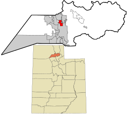 Location within Weber County and the State of Utah | |
| Coordinates: 41°17′7″N 111°59′12″W / 41.28528°N 111.98667°WCoordinates: 41°17′7″N 111°59′12″W / 41.28528°N 111.98667°W | |
| Country | United States |
| State | Utah |
| County | Weber |
| Settled | 1850 |
| Founded by | Urban Stewart |
| Named for | Martin H. Harris |
| Area | |
| • Total | 2.7 sq mi (7.0 km2) |
| • Land | 2.7 sq mi (7.0 km2) |
| • Water | 0.0 sq mi (0.0 km2) |
| Elevation | 4,291 ft (1,308 m) |
| Population (2012) | |
| • Total | 5,804 |
| • Density | 1,347.6/sq mi (520.3/km2) |
| Time zone | UTC-7 (Mountain (MST)) |
| • Summer (DST) | UTC-6 (MDT) |
| ZIP code | 84404 |
| Area code(s) | 385, 801 |
| FIPS code | 49-33540[1] |
| GNIS feature ID | 1441617[2] |
| Website |
www |
Harrisville is a city in Weber County, Utah, United States. The population was 3,645 at the 2000 census. It is part of the Ogden–Clearfield, Utah Metropolitan Statistical Area.
History
The first permanent settlement at Harrisville was made in 1850.[3] A post office called Harrisville was established in 1871, and remained in operation until 1902.[4] The community was named after Martin H. Harris, a pioneer settler.[3]
Geography
According to the United States Census Bureau, the city has a total area of 2.7 square miles (7.0 km²), all of it land.
Demographics
| Historical population | |||
|---|---|---|---|
| Census | Pop. | %± | |
| 1880 | 582 | — | |
| 1890 | 715 | 22.9% | |
| 1900 | 319 | −55.4% | |
| 1910 | 396 | 24.1% | |
| 1920 | 488 | 23.2% | |
| 1930 | 509 | 4.3% | |
| 1940 | 572 | 12.4% | |
| 1950 | 761 | 33.0% | |
| 1970 | 749 | — | |
| 1980 | 1,371 | 83.0% | |
| 1990 | 3,004 | 119.1% | |
| 2000 | 3,645 | 21.3% | |
| 2010 | 5,567 | 52.7% | |
| Est. 2016 | 6,376 | [5] | 14.5% |
| U.S. Decennial Census[6] | |||
As of the census[1] of 2000, there were 3,645 people, 1,010 households, and 884 families residing in the city. The population density was 1,347.6 people per square mile (521.2/km²). There were 1,036 housing units at an average density of 383.0 per square mile (148.1/km²). The racial makeup of the city was 93.77% White, 0.41% African American, 0.41% Native American, 1.15% Asian, 0.36% Pacific Islander, 2.33% from other races, and 1.56% from two or more races. Hispanic or Latino of any race were 4.66% of the population.
There were 1,010 households out of which 58.5% had children under the age of 18 living with them, 77.5% were married couples living together, 7.4% had a female householder with no husband present, and 12.4% were non-families. 10.3% of all households were made up of individuals and 3.3% had someone living alone who was 65 years of age or older. The average household size was 3.61 and the average family size was 3.89.
In the city, the population was spread out with 39.3% under the age of 18, 10.2% from 18 to 24, 30.5% from 25 to 44, 15.5% from 45 to 64, and 4.5% who were 65 years of age or older. The median age was 26 years. For every 100 females, there were 102.4 males. For every 100 females age 18 and over, there were 100.9 males.
The median income for a household in the city was $51,289, and the median income for a family was $53,396. Males had a median income of $38,287 versus $29,239 for females. The per capita income for the city was $16,293. About 2.6% of families and 3.6% of the population were below the poverty line, including 5.2% of those under age 18 and 3.8% of those age 65 or over.
See also
References
- 1 2 "American FactFinder". United States Census Bureau. Retrieved 2008-01-31.
- ↑ "US Board on Geographic Names". United States Geological Survey. 2007-10-25. Retrieved 2008-01-31.
- 1 2 The Utah Genealogical and Historical Magazine, Volumes 9-10. 1918. p. 186.
- ↑ "Post Offices". Retrieved 22 January 2018.
- ↑ "Population and Housing Unit Estimates". Retrieved June 9, 2017.
- ↑ "Census of Population and Housing". Census.gov. Retrieved June 4, 2015.
External links
Places adjacent to Harrisville, Utah | ||||||||||
|---|---|---|---|---|---|---|---|---|---|---|
| ||||||||||
Municipalities and communities of Weber County, Utah, United States | ||
|---|---|---|
| Cities | 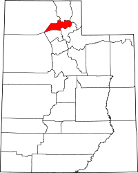 | |
| Town | ||
| CDPs | ||
| Unincorporated communities | ||