Beaver County, Utah
| Beaver County, Utah | |
|---|---|
 | |
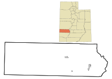
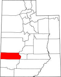 Location in the U.S. state of Utah | |
 Utah's location in the U.S. | |
| 38°20′N 113°14′W / 38.34°N 113.23°WCoordinates: 38°20′N 113°14′W / 38.34°N 113.23°W | |
| Founded | 1856 |
| Named for | North American beaver |
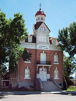
| Seat | Beaver |
| Largest city | Beaver |
| Area | |
| • Total | 2,592 sq mi (6,713 km2) |
| • Land | 2,590 sq mi (6,708 km2) |
| • Water | 2.1 sq mi (5 km2), 0.08% |
| Population (est.) | |
| • (2016) | 6,463[1] |
| • Density | 2.6/sq mi (1.0/km2) |
| Congressional district | 2nd |
| Time zone | Mountain: UTC−7/−6 |
| Website |
beaver |
Beaver County is a county located in west central Utah, United States. As of the 2010 census, the population was 6,629.[2] Its county seat and largest city is Beaver.[3] The county was named for the abundance of beavers in the area.
History
While explorers first visited present-day Beaver County in the 1776 Dominguez–Escalante Expedition, the county was created by the Utah territorial legislature from a section of Iron County on January 5, 1856 when Mormon settlers founded the city of Beaver, Utah. The county was named after the animal which was plentiful there.[4]
Geography
According to the U.S. Census Bureau, the county has a total area of 2,592 square miles (6,710 km2), of which 2,590 square miles (6,700 km2) is land and 2.1 square miles (5.4 km2) (0.08%) is water.[5] The Tushar Mountains lie on the eastern boundary of the county, reaching to 12,000 feet (3,700 m) in elevation, and providing water for the farming communities of Beaver and Manderfield. To the west, barren desert valleys typify the scenery, separated by mountains lightly forested with junipers.
Adjacent counties
- Lincoln County, Nevada (west)
- Millard County (north)
- Iron County (south)
- Sevier County (east)
- Piute County (east)
National protected area
- Fishlake National Forest (part)
| Historical population | |||
|---|---|---|---|
| Census | Pop. | %± | |
| 1860 | 785 | — | |
| 1870 | 2,007 | 155.7% | |
| 1880 | 3,918 | 95.2% | |
| 1890 | 3,340 | −14.8% | |
| 1900 | 3,613 | 8.2% | |
| 1910 | 4,717 | 30.6% | |
| 1920 | 5,139 | 8.9% | |
| 1930 | 5,136 | −0.1% | |
| 1940 | 5,014 | −2.4% | |
| 1950 | 4,856 | −3.2% | |
| 1960 | 4,331 | −10.8% | |
| 1970 | 3,800 | −12.3% | |
| 1980 | 4,378 | 15.2% | |
| 1990 | 4,765 | 8.8% | |
| 2000 | 6,005 | 26.0% | |
| 2010 | 6,629 | 10.4% | |
| Est. 2016 | 6,463 | [6] | −2.5% |
| U.S. Decennial Census[7] 1790–1960[8] 1900–1990[9] 1990–2000[10] 2010–2014[2] | |||
Demographics
As of the 2010 United States Census, there were 6,629 people, 2,265 households, and 1,697 families residing in the county.[11] The population density was 2.6 inhabitants per square mile (1.0/km2). There were 2,908 housing units at an average density of 1.1 per square mile (0.42/km2).[12] The racial makeup of the county was 89.0% white, 1.1% Asian, 1.1% American Indian, 0.3% Pacific islander, 0.2% black or African American, 6.9% from other races, and 1.4% from two or more races. Those of Hispanic or Latino origin made up 10.8% of the population.[11] In terms of ancestry, 35.2% were English, 15.5% were German, 10.6% were Irish, 6.8% were Scottish, and 2.3% were American.[13]
Of the 2,265 households, 41.8% had children under the age of 18 living with them, 63.2% were married couples living together, 7.2% had a female householder with no husband present, 25.1% were non-families, and 22.1% of all households were made up of individuals. The average household size was 2.92 and the average family size was 3.44. The median age was 31.9 years.[11]
The median income for a household in the county was $41,514 and the median income for a family was $46,426. Males had a median income of $40,167 versus $26,215 for females. The per capita income for the county was $16,131. About 12.6% of families and 17.9% of the population were below the poverty line, including 25.1% of those under age 18 and 15.3% of those age 65 or over.[14]
Politics
| Year | Republican | Democratic | Third parties |
|---|---|---|---|
| 2016 | 73.4% 1,838 | 10.5% 264 | 16.1% 403 |
| 2012 | 84.9% 2,174 | 13.5% 346 | 1.6% 40 |
| 2008 | 75.5% 1,902 | 21.5% 542 | 2.9% 74 |
| 2004 | 79.5% 2,023 | 19.4% 493 | 1.1% 28 |
| 2000 | 73.4% 1,653 | 24.0% 541 | 2.6% 58 |
| 1996 | 55.6% 1,164 | 32.8% 687 | 11.6% 243 |
| 1992 | 49.3% 1,040 | 31.6% 668 | 19.1% 403 |
| 1988 | 60.9% 1,286 | 38.6% 816 | 0.5% 10 |
| 1984 | 68.0% 1,516 | 31.7% 708 | 0.3% 7 |
| 1980 | 68.5% 1,477 | 28.8% 621 | 2.7% 59 |
| 1976 | 52.4% 1,088 | 46.4% 963 | 1.2% 25 |
| 1972 | 64.9% 1,332 | 33.2% 682 | 1.9% 39 |
| 1968 | 50.9% 989 | 40.9% 795 | 8.2% 160 |
| 1964 | 40.0% 792 | 60.0% 1,189 | |
| 1960 | 45.7% 971 | 54.4% 1,156 | |
| 1956 | 53.6% 1,190 | 46.4% 1,030 | |
| 1952 | 55.2% 1,277 | 44.8% 1,038 | |
| 1948 | 46.7% 1,057 | 52.6% 1,190 | 0.8% 17 |
| 1944 | 45.9% 958 | 54.0% 1,128 | 0.1% 2 |
| 1940 | 45.8% 1,101 | 54.2% 1,303 | 0.0% 1 |
| 1936 | 40.4% 913 | 59.1% 1,337 | 0.5% 11 |
| 1932 | 44.0% 969 | 55.3% 1,218 | 0.6% 14 |
| 1928 | 55.0% 1,149 | 44.8% 936 | 0.2% 5 |
| 1924 | 53.3% 989 | 31.2% 578 | 15.5% 287 |
| 1920 | 57.5% 1,056 | 40.3% 741 | 2.2% 40 |
| 1916 | 38.4% 842 | 58.8% 1,291 | 2.8% 61 |
| 1912 | 39.8% 671 | 35.7% 602 | 24.6% 415 |
| 1908 | 56.0% 945 | 42.3% 714 | 1.7% 28 |
| 1904 | 58.2% 869 | 39.7% 593 | 2.1% 32 |
| 1900 | 51.9% 682 | 47.9% 629 | 0.2% 3 |
| 1896 | 16.2% 205 | 83.8% 1,057 |
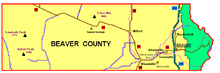
Communities
- Adamsville
- Beaver (county seat)
- Greenville
- Manderfield
- Milford
- Minersville
Recreation
- The American Discovery Trail traverses the county running through both Beaver and Milford.
- Elk Mountain is home to the Eagle Point Ski area.
- Rock Corral Recreation Area, an area of geologic interest managed by the BLM
See also
References
- Specific
- ↑ "Population and Housing Unit Estimates". U.S. Census Bureau. August 15, 2017. Retrieved August 15, 2017.
- 1 2 "State & County QuickFacts". United States Census Bureau. Retrieved December 29, 2013.
- ↑ "Find a County". National Association of Counties. Archived from the original on 2012-07-12. Retrieved 2011-06-07.
- ↑ Van Cott, J. W., 1990, Utah Place Names, ISBN 0-87480-345-4
- ↑ "2010 Census Gazetteer Files". United States Census Bureau. August 22, 2012. Retrieved March 27, 2015.
- ↑ "Population and Housing Unit Estimates". Retrieved June 9, 2017.
- ↑ "U.S. Decennial Census". United States Census Bureau. Archived from the original on May 12, 2015. Retrieved March 27, 2015.
- ↑ "Historical Census Browser". University of Virginia Library. Retrieved March 27, 2015.
- ↑ Forstall, Richard L., ed. (March 27, 1995). "Population of Counties by Decennial Census: 1900 to 1990". United States Census Bureau. Retrieved March 27, 2015.
- ↑ "Census 2000 PHC-T-4. Ranking Tables for Counties: 1990 and 2000" (PDF). United States Census Bureau. April 2, 2001. Retrieved March 27, 2015.
- 1 2 3 "DP-1 Profile of General Population and Housing Characteristics: 2010 Demographic Profile Data". United States Census Bureau. Retrieved 2016-01-23.
- ↑ "Population, Housing Units, Area, and Density: 2010 - County". United States Census Bureau. Retrieved 2016-01-23.
- ↑ "DP02 SELECTED SOCIAL CHARACTERISTICS IN THE UNITED STATES – 2006-2010 American Community Survey 5-Year Estimate". United States Census Bureau. Retrieved 2016-01-23.
- ↑ "DP03 SELECTED ECONOMIC CHARACTERISTICS – 2006-2010 American Community Survey 5-Year Estimates". United States Census Bureau. Retrieved 2016-01-23.
- ↑ Leip, David. "Dave Leip's Atlas of U.S. Presidential Elections". uselectionatlas.org. Retrieved 2018-03-30.
- General
- Murphy, Miriam B. (1994), "Beaver County", in Powell, Allan Kent, Utah History Encyclopedia, Salt Lake City, Utah: University of Utah Press, ISBN 0874804256, OCLC 30473917
External links
| Wikimedia Commons has media related to Beaver County, Utah. |
Places adjacent to Beaver County, Utah | ||||||||||
|---|---|---|---|---|---|---|---|---|---|---|
| ||||||||||
Municipalities and communities of Beaver County, Utah, United States | ||
|---|---|---|
| Cities | | |
| Town | ||
| Unincorporated communities | ||
| Ghost towns | ||