Garfield County, Utah
| Garfield County, Utah | |
|---|---|
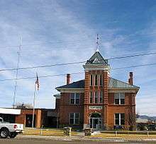 Garfield County Courthouse in Panguitch, December 2006 | |
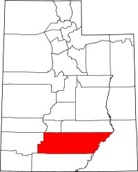 Location in the U.S. state of Utah | |
 Utah's location in the U.S. | |
| 37°52′N 111°26′W / 37.87°N 111.44°WCoordinates: 37°52′N 111°26′W / 37.87°N 111.44°W | |
| Founded | 1882 |
| Named for | James A. Garfield |
| Seat | Panguitch |
| Largest city | Panguitch |
| Area | |
| • Total | 5,208 sq mi (13,489 km2) |
| • Land | 5,175 sq mi (13,403 km2) |
| • Water | 33 sq mi (85 km2), 0.6% |
| Population (est.) | |
| • (2017) | 5,078[1] |
| • Density | 1.0/sq mi (0.4/km2) |
| Congressional district | 2nd |
| Time zone | Mountain: UTC−7/−6 |
| Website |
garfield |
Garfield County is a county located in south central Utah, United States. As of the 2010 census, the population was 5,172,[2] making it the fifth-least populous county in Utah. Its county seat and largest city is Panguitch.[3]
History
Garfield County was founded in 1882. It was named for James A. Garfield, late President of the United States,[4] who had been assassinated in 1881.
Geography
According to the U.S. Census Bureau, the county has a total area of 5,208 square miles (13,490 km2), of which 5,175 square miles (13,400 km2) is land and 33 square miles (85 km2) (0.6%) is water.[5] It is the fifth-largest county in Utah by area. The Colorado River, passing through a deep gorge, forms the eastern boundary. Westward, the cliffs of tributary canyons give way to the barren stretches of the San Rafael Desert, beyond which a variety of mountains, plateaus and canyons make up the terrain. Most of Bryce Canyon National Park lies in the southwestern part of the county and the northern half of the Grand Staircase-Escalante National Monument occupies the middle of the county. A large portion of Capitol Reef National Park lies in the east-central part of the county. A very small part of Canyonlands National Park lies in the northeast corner of the county.
Adjacent counties
- Wayne County (north)
- San Juan County (east)
- Kane County (south)
- Iron County (west)
- Beaver County (northwest)
- Piute County (northwest)
National protected areas
- Bryce Canyon National Park (part)
- Canyonlands National Park (part)
- Capitol Reef National Park (part)
- Dixie National Forest (part)
- Fishlake National Forest (part)
- Glen Canyon National Recreation Area (part)
- Grand Staircase-Escalante National Monument (part)
Demographics
| Historical population | |||
|---|---|---|---|
| Census | Pop. | %± | |
| 1890 | 2,457 | — | |
| 1900 | 3,400 | 38.4% | |
| 1910 | 3,660 | 7.6% | |
| 1920 | 4,768 | 30.3% | |
| 1930 | 4,642 | −2.6% | |
| 1940 | 5,253 | 13.2% | |
| 1950 | 4,151 | −21.0% | |
| 1960 | 3,577 | −13.8% | |
| 1970 | 3,157 | −11.7% | |
| 1980 | 3,673 | 16.3% | |
| 1990 | 3,980 | 8.4% | |
| 2000 | 4,735 | 19.0% | |
| 2010 | 5,172 | 9.2% | |
| Est. 2017 | 5,078 | [6] | −1.8% |
| U.S. Decennial Census[7] 1790–1960[8] 1900–1990[9] 1990–2000[10] 2010–2014[2] | |||
As of the census[11] of 2000, there were 4,735 people, 1,576 households, and 1,199 families residing in the county. The population density was 1 person per square mile (0/km²). There were 2,767 housing units at an average density of 0 per square mile (0/km²). The racial makeup of the county was 94.95% White, 0.17% Black or African American, 1.84% Native American, 0.40% Asian, 0.04% Pacific Islander, 1.12% from other races, and 1.48% from two or more races. 2.87% of the population were Hispanic or Latino of any race.
There were 1,576 households out of which 38.40% had children under the age of 18 living with them, 66.40% were married couples living together, 6.80% had a female householder with no husband present, and 23.90% were non-families. 20.50% of all households were made up of individuals and 10.10% had someone living alone who was 65 years of age or older. The average household size was 2.92 and the average family size was 3.43.
In the county, the population was spread out with 32.60% under the age of 18, 7.80% from 18 to 24, 23.10% from 25 to 44, 22.40% from 45 to 64, and 14.10% who were 65 years of age or older. The median age was 34 years. For every 100 females there were 104.60 males. For every 100 females age 18 and over, there were 102.20 males.
The median income for a household in the county was $35,180, and the median income for a family was $40,192. Males had a median income of $30,239 versus $20,408 for females. The per capita income for the county was $13,439. About 6.10% of families and 8.10% of the population were below the poverty line, including 8.80% of those under age 18 and 10.40% of those age 65 or over.
As of 2010 the largest self-identified ancestry groups in Garfield County are:
- English - 46.2%
- German - 14.8%
- Irish - 10.1%
- Danish - 6.6%
- Scottish - 4.9%
- Welsh - 3.9%
- Scotch-Irish - 2.5%
- Swedish - 2.3%
- Norwegian - 2.2%[12]
Politics
| Year | Republican | Democratic | Third parties |
|---|---|---|---|
| 2016 | 68.5% 1,606 | 15.3% 358 | 16.2% 380 |
| 2012 | 84.0% 1,832 | 14.1% 308 | 1.9% 42 |
| 2008 | 78.4% 1,710 | 18.6% 405 | 3.1% 67 |
| 2004 | 85.5% 1,848 | 12.2% 264 | 2.3% 50 |
| 2000 | 87.4% 1,719 | 9.0% 178 | 3.6% 71 |
| 1996 | 72.0% 1,330 | 15.3% 283 | 12.7% 234 |
| 1992 | 62.3% 1,235 | 15.6% 309 | 22.1% 439 |
| 1988 | 79.3% 1,470 | 20.0% 370 | 0.8% 15 |
| 1984 | 83.2% 1,609 | 16.3% 315 | 0.6% 11 |
| 1980 | 78.3% 1,578 | 18.6% 375 | 3.1% 62 |
| 1976 | 65.5% 1,163 | 30.4% 539 | 4.2% 74 |
| 1972 | 80.5% 1,290 | 15.1% 242 | 4.4% 71 |
| 1968 | 69.5% 1,033 | 21.1% 314 | 9.4% 140 |
| 1964 | 55.5% 821 | 44.5% 658 | |
| 1960 | 69.7% 1,083 | 30.3% 471 | |
| 1956 | 76.0% 1,115 | 24.1% 353 | |
| 1952 | 69.1% 1,065 | 30.9% 477 | |
| 1948 | 59.0% 924 | 41.0% 642 | 0.1% 1 |
| 1944 | 60.1% 842 | 39.9% 559 | 0.1% 1 |
| 1940 | 55.9% 1,030 | 44.1% 814 | |
| 1936 | 47.5% 842 | 52.4% 928 | 0.1% 2 |
| 1932 | 68.4% 1,125 | 30.0% 493 | 1.6% 26 |
| 1928 | 75.6% 1,024 | 24.0% 325 | 0.4% 5 |
| 1924 | 69.6% 823 | 26.0% 308 | 4.4% 52 |
| 1920 | 71.5% 1,023 | 27.5% 393 | 1.1% 15 |
| 1916 | 37.5% 516 | 61.3% 843 | 1.2% 17 |
| 1912 | 62.6% 673 | 23.2% 249 | 14.2% 153 |
| 1908 | 68.5% 722 | 27.5% 290 | 4.0% 42 |
| 1904 | 70.1% 679 | 26.0% 252 | 3.8% 37 |
| 1900 | 62.2% 649 | 37.8% 395 | |
| 1896 | 28.8% 249 | 71.2% 615 |
Communities
- Antimony
- Bryce
- Bryce Canyon City
- Boulder
- Cannonville
- Escalante
- Hatch
- Henrieville
- Panguitch (county seat)
- Ticaboo
- Tropic
See also
References
- ↑ "Community Facts". Factfinder. United States Census Bureau.
- 1 2 "State & County QuickFacts". United States Census Bureau. Archived from the original on July 10, 2011. Retrieved December 29, 2013.
- ↑ "Find a County". National Association of Counties. Archived from the original on 2011-05-31. Retrieved 2011-06-07.
- ↑ Gannett, Henry (1905). The Origin of Certain Place Names in the United States. Govt. Print. Off. p. 134.
- ↑ "2010 Census Gazetteer Files". United States Census Bureau. August 22, 2012. Retrieved March 27, 2015.
- ↑ "Population and Housing Unit Estimates". Retrieved June 9, 2017.
- ↑ "U.S. Decennial Census". United States Census Bureau. Archived from the original on May 12, 2015. Retrieved March 27, 2015.
- ↑ "Historical Census Browser". University of Virginia Library. Retrieved March 27, 2015.
- ↑ Forstall, Richard L., ed. (March 27, 1995). "Population of Counties by Decennial Census: 1900 to 1990". United States Census Bureau. Retrieved March 27, 2015.
- ↑ "Census 2000 PHC-T-4. Ranking Tables for Counties: 1990 and 2000" (PDF). United States Census Bureau. April 2, 2001. Retrieved March 27, 2015.
- ↑ "American FactFinder". United States Census Bureau. Archived from the original on 2013-09-11. Retrieved 2011-05-14.
- ↑ Bureau, U.S. Census. "American FactFinder - Results". factfinder.census.gov. Retrieved 2018-03-31.
- ↑ Leip, David. "Dave Leip's Atlas of U.S. Presidential Elections". uselectionatlas.org. Retrieved 2018-03-31.
External links

- Official website
Places adjacent to Garfield County, Utah | ||||||||||
|---|---|---|---|---|---|---|---|---|---|---|
| ||||||||||
Municipalities and communities of Garfield County, Utah, United States | ||
|---|---|---|
| Cities | | |
| Towns | ||
| Unincorporated communities | ||
| Ghost towns | ||