Cottonwood Heights, Utah
| Cottonwood Heights, Utah | |
|---|---|
| City | |
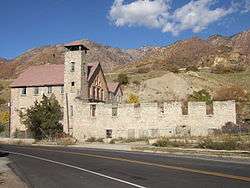 The old Cottonwood Paper Mill built in 1883 by the Deseret News in Cottonwood Heights. | |
| Nickname(s): city between the canyons | |
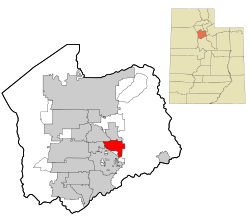 Location in Salt Lake County and the state of Utah. | |
| Coordinates: 40°37′2″N 111°49′13″W / 40.61722°N 111.82028°WCoordinates: 40°37′2″N 111°49′13″W / 40.61722°N 111.82028°W | |
| Country | United States |
| State | Utah |
| County | Salt Lake |
| Incorporated | January 14, 2005 |
| Named for | Cottonwood trees |
| Area | |
| • Total | 6.8 sq mi (17.6 km2) |
| • Land | 6.8 sq mi (17.6 km2) |
| • Water | 0.0 sq mi (0.0 km2) |
| Elevation | 4,823 ft (1,470 m) |
| Population (2012) | |
| • Total | 34,017 |
| • Density | 4,052.9/sq mi (1,564.8/km2) |
| Time zone | UTC−7 (Mountain (MST)) |
| • Summer (DST) | UTC−6 (MDT) |
| Area code(s) | 385, 801 |
| FIPS code | 49-16270[1] |
| GNIS feature ID | 1440025[2] |
| Website | Cottonwood Heights City Official Website |
Cottonwood Heights is a city located in Salt Lake County, Utah, United States, along the east bench of the Salt Lake Valley. It lies south of the cities of Holladay and Murray, east of Midvale, and north of Sandy within the Salt Lake City, Utah Metropolitan Statistical Area. Following a successful incorporation referendum in May 2004, the city was incorporated on January 14, 2005. Cottonwood Heights had been a Census-designated place (CDP) before incorporation. The population as of the 2010 census was 33,433.[3] This is a significant increase over the CDP's 2000 census count of 27,569.
The corporate offices of Dyno Nobel, Extra Space Storage, JetBlue Airways, Overstock.com and Fusion-io are located in the city.
In 2007, Money magazine rated Cottonwood Heights at #100 on their Best Places to Live list.
Geography
As the city's name suggest its geography is dominated by a high ridge separating the valleys of the Big and Little Cottonwood Creeks. At the eastern edge of the city, these valleys narrow into the Big and Little Cottonwood Canyons within the Wasatch Mountains, respectively; this is reflected by the city's official nickname, "City between the canyons". The ridge is covered in suburban housing, but most commercial development has been restricted to the lower-lying areas north of the ridge (along Fort Union Boulevard, in Fort Union itself, and near Big Cottonwood Creek and the "Old Mill" in the northeast corner of the city).
State Route 190 and State Route 210 run near the eastern edge of the city and provide access to the canyons; they are the only state routes that enter the city. Interstate 215 runs along the northern border of the city and State Route 152 touches the city at a point. The city is building a multi-use trail along the full length of Big Cottonwood Creek within its borders.
Cottonwood Heights is in the Canyons School District; Brighton High School is the only public high school in the city. Butler Middle school is the only middle school in city limits.
According to the United States Census Bureau, the CDP had a total area of 6.8 square miles (17.6 km²), all of it land.
Demographics
| Historical population | |||
|---|---|---|---|
| Census | Pop. | %± | |
| 1980 | 22,665 | — | |
| 1990 | 28,766 | 26.9% | |
| 2000 | 27,569 | −4.2% | |
| 2010 | 33,433 | 21.3% | |
| Est. 2016 | 34,285 | [4] | 2.5% |
| source:[5] | |||
According to estimates from the Kem C. Gardner Policy Institute of the University of Utah,[6] as of 2015, there were 34,234 people in Cottonwood Heights. The racial makeup of the county was 86.57% non-Hispanic White, 0.81% Black, 0.60% Native American, 4.51% Asian, 0.88% Pacific Islander, and 2.34% from two or more races. 4.29% of the population were Hispanic or Latino of any race.
Local media
- The Cottonwood/Holladay City Journal, newspaper, tabloid style newspaper covering local government, schools, sports, and features. Delivered to homes directly monthly by the USPS. Managed and Operated by Loyal Perch Media.
Police services
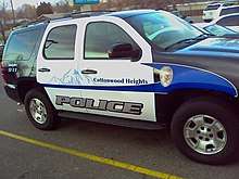
On January 8, 2008, the Cottonwood Heights City Council voted to create its own police department and withdraw from its current contract with the Salt Lake County Sheriff's Department.
See also
References
- ↑ "American FactFinder". United States Census Bureau. Archived from the original on 2013-09-11. Retrieved 2008-01-31.
- ↑ "US Board on Geographic Names". United States Geological Survey. 2007-10-25. Retrieved 2008-01-31.
- ↑ Utah Trend Report 2: State and Complete Places (Sub-state 2010 Census Data). Missouri Census Data Center. Accessed 2011-02-26.
- ↑ "Population and Housing Unit Estimates". Retrieved June 9, 2017.
- ↑ "CENSUS OF POPULATION AND HOUSING (1790-2000)". U.S. Census Bureau. Retrieved 2010-07-31.
- ↑ "Salt Lake City Data Book 2017" (PDF). Kem C. Gardner Policy Institute. Retrieved April 16, 2018.
External links
| Wikimedia Commons has media related to Cottonwood Heights, Utah. |
Places adjacent to Cottonwood Heights, Utah | |
|---|---|
Municipalities and communities of Salt Lake County, Utah, United States | ||
|---|---|---|
| Cities |  | |
| Town | ||
| Townships | ||
| CDPs | ||
| Unincorporated community | ||
| Ghost towns | ||
| Footnotes | ‡This populated place also has portions in an adjacent county or counties | |