| [3] |
Name on the Register[4] |
Image |
Date listed[5] |
Location |
City or town |
Description |
|---|
| 1 |
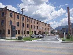
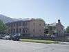
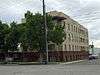
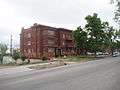
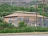
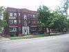
American Can Company of Utah Building Complex |
|
November 16, 2005
(#05001303) |
2030 Lincoln Ave.
41°13′49″N 111°58′28″W / 41.230278°N 111.974444°W / 41.230278; -111.974444 (American Can Company of Utah Building Complex) |
Ogden |
|
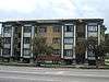
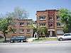
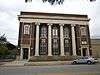
| 2 |
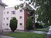
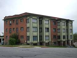
Arvondor Apartments |
|
December 31, 1987
(#87002156) |
823 23rd St.
41°13′28″N 111°57′27″W / 41.224444°N 111.9575°W / 41.224444; -111.9575 (Arvondor Apartments) |
Ogden |
|
| 3 |
Avelan Apartments |
|
December 31, 1987
(#87002157) |
449 27th St.
41°12′58″N 111°58′07″W / 41.216111°N 111.968611°W / 41.216111; -111.968611 (Avelan Apartments) |
Ogden |
|
| 4 |
Avon Apartments |
|
December 31, 1987
(#87002158) |
961 25th St.
41°13′13″N 111°57′14″W / 41.220278°N 111.953889°W / 41.220278; -111.953889 (Avon Apartments) |
Ogden |
|
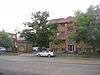
| 5 |
Barnhart Apartments |
|
December 31, 1987
(#87002159) |
336 27th St.
41°13′01″N 111°58′17″W / 41.216944°N 111.971389°W / 41.216944; -111.971389 (Barnhart Apartments) |
Ogden |
|
| 6 |
Gustav Becker House |
|
July 21, 1977
(#77001327) |
2408 Van Buren Ave.
41°13′21″N 111°57′00″W / 41.2225°N 111.95°W / 41.2225; -111.95 (Gustav Becker House) |
Ogden |
|
| 7 |
Ben Lomond Hotel Garage |
|
August 28, 2012
(#12000591) |
455 25th St.
41°13′14″N 111°58′08″W / 41.220556°N 111.968889°W / 41.220556; -111.968889 (Ben Lomond Hotel Garage) |
Ogden |
|
| 8 |
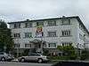
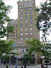
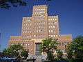
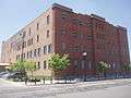
Bigelow-Ben Lomond Hotel |
|
April 19, 1990
(#90000637) |
2510 Washington Boulevard
41°13′14″N 111°58′10″W / 41.220556°N 111.969444°W / 41.220556; -111.969444 (Bigelow-Ben Lomond Hotel) |
Ogden |
|
| 9 |
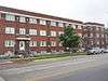
Browning Apartments |
|
December 19, 1985
(#85003200) |
2703 Washington Boulevard
41°12′58″N 111°58′13″W / 41.216111°N 111.970278°W / 41.216111; -111.970278 (Browning Apartments) |
Ogden |
|
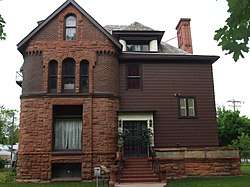
| 10 |
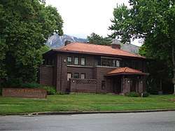
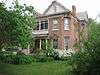
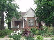
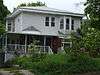
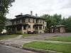
John Moses Browning House |
|
April 24, 1973
(#73001863) |
505 27th St.
41°12′58″N 111°58′00″W / 41.216111°N 111.966667°W / 41.216111; -111.966667 (John Moses Browning House) |
Ogden |
Home of John Browning |
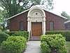
| 11 |
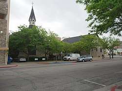
Congregation B'rith Sholem Synagogue |
|
June 27, 1985
(#85001394) |
2750 Grant Ave.
41°12′56″N 111°58′21″W / 41.215556°N 111.9725°W / 41.215556; -111.9725 (Congregation B'rith Sholem Synagogue) |
Ogden |
|
| 12 |
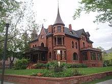
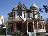
Charles W. Cross House |
|
July 12, 1984
(#84002434) |
451 17th St.
41°14′10″N 111°58′05″W / 41.236111°N 111.968056°W / 41.236111; -111.968056 (Charles W. Cross House) |
Ogden |
|
| 13 |
John L. and Elizabeth Dalton House |
|
March 11, 1987
(#86003659) |
2622 Madison Ave.
41°13′05″N 111°57′41″W / 41.218056°N 111.961389°W / 41.218056; -111.961389 (John L. and Elizabeth Dalton House) |
Ogden |
|
| 14 |
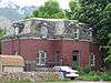
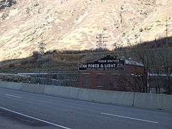
Devil's Gate-Weber Hydroelectric Power Plant Historic District |
|
April 20, 1989
(#89000276) |
I-84 east of its junction with US-89, in Weber Canyon
41°08′18″N 111°52′02″W / 41.138333°N 111.867222°W / 41.138333; -111.867222 (Devil's Gate-Weber Hydroelectric Power Plant Historic District) |
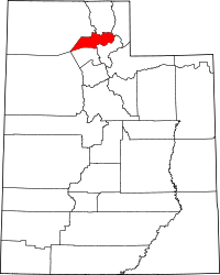
Uintah |
|
| 15 |
John F. and Lillia Dumke House |
|
February 14, 2007
(#07000078) |
1607 Kiesel Ave.
41°14′19″N 111°58′17″W / 41.238611°N 111.971389°W / 41.238611; -111.971389 (John F. and Lillia Dumke House) |
Ogden |
|
| 16 |
Eccles Avenue Historic District |
|
December 12, 1976
(#76001840) |
Bounded by 25th and 26th Sts. and Van Buren and Jackson Aves.
41°13′10″N 111°57′05″W / 41.219444°N 111.951389°W / 41.219444; -111.951389 (Eccles Avenue Historic District) |
Ogden |
|
| 17 |
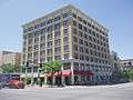
Eccles Building |
|
July 14, 1982
(#82004187) |
385 24th St.
41°13′22″N 111°58′10″W / 41.222778°N 111.969444°W / 41.222778; -111.969444 (Eccles Building) |
Ogden |
|
| 18 |
Bertha Eccles Community Art Center |
|
May 14, 1971
(#71000865) |
2580 Jefferson Ave.
41°13′07″N 111°57′50″W / 41.218611°N 111.963889°W / 41.218611; -111.963889 (Bertha Eccles Community Art Center) |
Ogden |
|
| 19 |
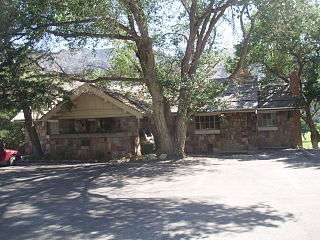
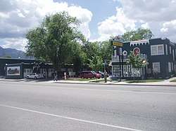
El Monte Golf Course Clubhouse |
|
April 1, 1985
(#85000823) |
1300 Valley Dr.
41°14′01″N 111°56′40″W / 41.233611°N 111.944444°W / 41.233611; -111.944444 (El Monte Golf Course Clubhouse) |
Ogden |
|
| 20 |
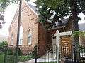
Episcopal Church of the Good Shepherd |
|
April 3, 1973
(#73001864) |
2374 Grant Ave.
41°13′23″N 111°58′19″W / 41.223056°N 111.971944°W / 41.223056; -111.971944 (Episcopal Church of the Good Shepherd) |
Ogden |
|
| 21 |
Fairview Apartments |
|
December 31, 1987
(#87002161) |
579–587 27th St.
41°12′58″N 111°57′55″W / 41.216111°N 111.965278°W / 41.216111; -111.965278 (Fairview Apartments) |
Ogden |
|
| 22 |
Farnsworth Apartments |
|
December 31, 1987
(#87002162) |
2539 Jefferson Ave.
41°13′11″N 111°57′54″W / 41.219722°N 111.965°W / 41.219722; -111.965 (Farnsworth Apartments) |
Ogden |
|
| 23 |
Valasco Farr House |
|
June 13, 1978
(#78002712) |
700 Canyon Rd.
41°14′17″N 111°57′40″W / 41.238056°N 111.961111°W / 41.238056; -111.961111 (Valasco Farr House) |
Ogden |
|
| 24 |
Fern-Marylyn Apartments |
|
December 31, 1987
(#87002163) |
2579 Adams Ave.
41°13′08″N 111°58′03″W / 41.218889°N 111.9675°W / 41.218889; -111.9675 (Fern-Marylyn Apartments) |
Ogden |
|
| 25 |
Flowers Apartments |
|
December 31, 1987
(#87002166) |
2681 Madison Ave.
41°13′01″N 111°57′43″W / 41.216944°N 111.961944°W / 41.216944; -111.961944 (Flowers Apartments) |
Ogden |
|
| 26 |
Fontenelle Apartments |
|
December 31, 1987
(#87002167) |
2465–2475 Monroe Ave.
41°13′16″N 111°57′32″W / 41.221111°N 111.958889°W / 41.221111; -111.958889 (Fontenelle Apartments) |
Ogden |
|
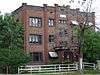
| 27 |
Geffas Apartments |
|
December 31, 1987
(#87002168) |
2675 Grant Ave.
41°13′01″N 111°58′23″W / 41.216944°N 111.973056°W / 41.216944; -111.973056 (Geffas Apartments) |
Ogden |
|
| 28 |
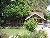
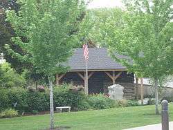
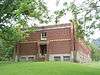
Miles Goodyear Cabin |
|
February 24, 1971
(#71000866) |
2104 Lincoln Ave.
41°13′44″N 111°58′32″W / 41.22875°N 111.975486°W / 41.22875; -111.975486 (Miles Goodyear Cabin) |
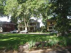
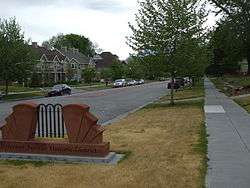
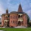
Ogden |
The first known permanent home in Utah, built circa 1841 by Miles Goodyear. Previously at 2148 Grant Ave., moved in December 2012 |
| 29 |
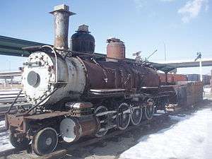
Grant Steam Locomotive No. 223 |
|
May 23, 1979
(#79002501) |
Union Station[6]
41°13′20″N 111°58′47″W / 41.222222°N 111.979861°W / 41.222222; -111.979861 (Grant Steam Locomotive No. 223) |
Ogden |
Moved from a previous location in Salt Lake City |
| 30 |
Helms Apartments |
|
December 31, 1987
(#87002169) |
2248–2250 Jefferson Ave.
41°13′33″N 111°57′50″W / 41.225833°N 111.963889°W / 41.225833; -111.963889 (Helms Apartments) |
Ogden |
|
| 31 |
Hillcrest Apartments |
|
December 31, 1987
(#87002170) |
2485 Monroe Ave.
41°13′15″N 111°57′33″W / 41.220833°N 111.959167°W / 41.220833; -111.959167 (Hillcrest Apartments) |
Ogden |
|
| 32 |
Jefferson Avenue Historic District |
|
September 25, 1998
(#98001214) |
Roughly along Jefferson Ave. between 25th and 27th Sts.
41°13′07″N 111°57′54″W / 41.218611°N 111.965°W / 41.218611; -111.965 (Jefferson Avenue Historic District) |
Ogden |
|
| 33 |
La Frantz Apartments |
|
December 31, 1987
(#87002172) |
461 27th St.
41°12′58″N 111°58′07″W / 41.216111°N 111.968611°W / 41.216111; -111.968611 (La Frantz Apartments) |
Ogden |
|
| 34 |
Ladywood Apartments |
|
December 31, 1987
(#87002171) |
670–690 26th St.
41°13′07″N 111°57′43″W / 41.218611°N 111.961944°W / 41.218611; -111.961944 (Ladywood Apartments) |
Ogden |
|
| 35 |
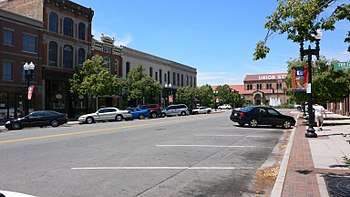
Lower 25th Street Historic District |
|
January 31, 1978
(#78003260) |
25th St. between Wall and Grant Aves.; also 2522 Wall Ave.; also 2471 Grant Ave.
41°13′08″N 111°58′33″W / 41.218977°N 111.975746°W / 41.218977; -111.975746 (Lower 25th Street Historic District) |
Ogden |
Second and third addresses represent separate boundary increases |
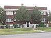
| 36 |
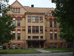
Madison Elementary School |
|
February 19, 1982
(#82004188) |
2434 Madison Ave.
41°13′18″N 111°57′38″W / 41.221667°N 111.960556°W / 41.221667; -111.960556 (Madison Elementary School) |
Ogden |
|
| 37 |
Don Maguire Duplex |
|
February 26, 1979
(#79002521) |
549–551 25th St.
41°13′14″N 111°57′58″W / 41.220556°N 111.966111°W / 41.220556; -111.966111 (Don Maguire Duplex) |
Ogden |
|
| 38 |
McGregor Apartments |
|
December 31, 1987
(#87002173) |
802–810 25th St.
41°13′16″N 111°57′30″W / 41.221111°N 111.958333°W / 41.221111; -111.958333 (McGregor Apartments) |
Ogden |
|
| 39 |
Mountain View Auto Court |
|
November 24, 1987
(#87002063) |
563 W. 24th St.
41°13′22″N 111°59′26″W / 41.222778°N 111.990556°W / 41.222778; -111.990556 (Mountain View Auto Court) |
Ogden |
|
| 40 |
New Brigham Hotel |
|
June 14, 1979
(#79002522) |
2402–2410 Wall Ave.
41°13′21″N 111°58′41″W / 41.2225°N 111.978056°W / 41.2225; -111.978056 (New Brigham Hotel) |
Ogden |
|
| 41 |
Ogden Central Bench Historic District |
|
July 22, 2005
(#03000055) |
20th St to 30th St., Adams Ave. to Harrison Boulevard
41°13′07″N 111°57′30″W / 41.218611°N 111.958333°W / 41.218611; -111.958333 (Ogden Central Bench Historic District) |
Ogden |
|
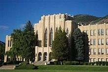
| 42 |
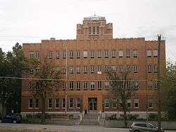
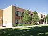
Ogden High School |
|
June 7, 1983
(#83003201) |
2828 Harrison Boulevard
41°12′47″N 111°56′46″W / 41.213056°N 111.946111°W / 41.213056; -111.946111 (Ogden High School) |
Ogden |
|
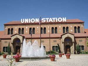
| 43 |
Ogden Union Station |
|
April 11, 1971
(#71000867) |
25th St. at Wall Ave.; also 2501 Wall Ave.
41°13′14″N 111°58′43″W / 41.220556°N 111.978611°W / 41.220556; -111.978611 (Ogden Union Station) |
Ogden |
2501 Wall Ave. represents a boundary increase |
| 44 |
Ogden Union Stockyard Exchange Building |
|
July 21, 2015
(#15000452) |
600 W. Exchange Rd.
41°13′31″N 111°59′31″W / 41.2253°N 111.9919°W / 41.2253; -111.9919 (Ogden Union Stockyard Exchange Building) |
Ogden |
|
| 45 |
Ogden/Weber Municipal Building |
|
June 7, 1983
(#83003202) |
2541 Washington Boulevard
41°13′11″N 111°58′13″W / 41.219722°N 111.970278°W / 41.219722; -111.970278 (Ogden/Weber Municipal Building) |
Ogden |
|
| 46 |
Augustus B. Patton House |
|
February 19, 1982
(#82004189) |
1506 24th St.
41°13′21″N 111°56′21″W / 41.2225°N 111.939167°W / 41.2225; -111.939167 (Augustus B. Patton House) |
Ogden |
|
| 47 |
Peery Apartments |
|
December 31, 1987
(#87002174) |
2461 Adams Ave.
41°13′16″N 111°58′03″W / 41.221111°N 111.9675°W / 41.221111; -111.9675 (Peery Apartments) |
Ogden |
|
| 48 |
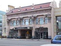
Peery's Egyptian Theatre |
|
December 12, 1978
(#78002714) |
2439 Washington Boulevard
41°13′18″N 111°58′12″W / 41.221667°N 111.97°W / 41.221667; -111.97 (Peery's Egyptian Theatre) |
Ogden |
|
| 49 |
Pioneer Hydroelectric Power Plant Historic District |
|
April 21, 1989
(#89000275) |
12th St. at Canyon Rd.
41°14′38″N 111°56′46″W / 41.243889°N 111.946111°W / 41.243889; -111.946111 (Pioneer Hydroelectric Power Plant Historic District) |
Ogden |
|
| 50 |
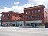
Scowcroft Warehouse |
|
November 30, 1978
(#78002715) |
105 23rd St.
41°13′29″N 111°58′39″W / 41.224722°N 111.9775°W / 41.224722; -111.9775 (Scowcroft Warehouse) |
Ogden |
|
| 51 |
Heber Scowcroft House |
|
December 13, 1991
(#91001818) |
795 24th St.
41°13′18″N 111°57′31″W / 41.221667°N 111.958611°W / 41.221667; -111.958611 (Heber Scowcroft House) |
Ogden |
|
| 52 |
William D. Skeen House |
|
August 9, 1982
(#82004191) |
2419 N. 4500 West[7]
41°18′16″N 112°05′08″W / 41.304444°N 112.085556°W / 41.304444; -112.085556 (William D. Skeen House) |
Plain City |
|
| 53 |
Dennis A. Smyth House |
|
February 11, 1982
(#82004190) |
635 25th St.
41°13′13″N 111°57′47″W / 41.220278°N 111.963056°W / 41.220278; -111.963056 (Dennis A. Smyth House) |
Ogden |
|
| 54 |
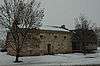
Stone Farmstead |
|
July 6, 2004
(#04000676) |
301 W. 2nd St.
41°15′33″N 111°59′01″W / 41.259167°N 111.983611°W / 41.259167; -111.983611 (Stone Farmstead) |
Ogden |
|
| 55 |
US Forest Service Building |
|
May 24, 2006
(#06000432) |
507 25th St.
41°13′13″N 111°58′00″W / 41.220278°N 111.966667°W / 41.220278; -111.966667 (US Forest Service Building) |
Ogden |
|
| 56 |
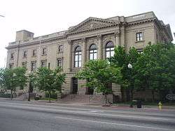
U.S. Post Office and Courthouse |
|
July 26, 1979
(#79002523) |
298 W. 24th St.
41°13′23″N 111°58′23″W / 41.223056°N 111.973056°W / 41.223056; -111.973056 (U.S. Post Office and Courthouse) |
Ogden |
|
| 57 |
Upton Apartments |
|
December 31, 1987
(#87002176) |
2300–2314 Jefferson Ave.
41°13′28″N 111°57′50″W / 41.224444°N 111.963889°W / 41.224444; -111.963889 (Upton Apartments) |
Ogden |
|
| 58 |
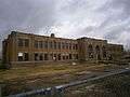
Utah School for the Deaf and Blind Boys' Dormitory |
|
April 1, 1985
(#85000824) |
846 20th St.
41°13′52″N 111°57′25″W / 41.231111°N 111.956944°W / 41.231111; -111.956944 (Utah School for the Deaf and Blind Boys' Dormitory) |
Ogden |
|
| 59 |
Andrew J. Warner House |
|
December 13, 1977
(#77001328) |
726 25th St.
41°13′16″N 111°57′37″W / 41.221111°N 111.960278°W / 41.221111; -111.960278 (Andrew J. Warner House) |
Ogden |
|
| 60 |
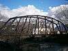
Weber River Railroad Bridge |
|
April 6, 2015
(#15000134) |
0.5 miles (0.80 km) west of Union Station along Exchange Rd.
41°13′24″N 111°59′18″W / 41.223201°N 111.988356°W / 41.223201; -111.988356 (Weber River Railroad Bridge) |
Ogden |
|
| 61 |
Weber Stake Relief Society Building |
|
February 13, 1989
(#88003438) |
2104 Lincoln Ave.
41°13′44″N 111°58′32″W / 41.228889°N 111.975556°W / 41.228889; -111.975556 (Weber Stake Relief Society Building) |
Ogden |
Houses the Weber County DUP Museum. Originally at 2148 Grant Ave., moved on January 24, 2012 |
| 62 |
J.M. Wilbur Company Blacksmith Shop |
|
January 17, 2017
(#100000513) |
2145 N 5500 E
41°17′50″N 111°48′56″W / 41.297315°N 111.815467°W / 41.297315; -111.815467 (J.M. Wilbur Company Blacksmith Shop) |
Eden |
|