Waikato
| Waikato | |
| Country: | New Zealand |
 | |
| Name: | Waikato Regional Council |
| Seat and largest city: | Hamilton City |
| Chair: | Alan Livingston[1] |
| Deputy chair: | Tipa Mahuta |
| Population: | 468,800 June 2018[2] |
| Land area: | Approximately 25,000 km2 or 2.5 million hectares |
| Website: | http://www.waikatoregion.govt.nz |
| Tangata whenua | |
|---|---|
| Local iwi | Ngāti Maniapoto, Ngāti Raukawa, Tainui, Ngāti Tūwharetoa |
| Cities and towns | |
| Cities: | Hamilton |
| Towns: | Cambridge, Coromandel, Huntly, Matamata, Miranda, Morrinsville, Ngaruawahia, Ngatea, Paeroa, Pirongia, Putaruru, Raglan, Taupiri, Taupo, Te Aroha, Te Awamutu, Te Kauwhata, Te Kowhai, Te Kuiti, Thames, Tirau, Tokoroa, Waihi |
| Constituent territorial authorities | |
| Names: | Hamilton City Waikato District South Waikato District Waipa District Thames-Coromandel District Matamata-Piako District Waitomo District (part) Otorohanga District Hauraki District Taupo District (part) Rotorua District (part) |

Waikato (/ˈwaɪkɑːtɔː/ or /ˈwaɪkætoʊ/) is a local government region of the upper North Island of New Zealand. It covers the Waikato District, Hauraki, Coromandel Peninsula, the northern King Country, much of the Taupo District, and parts of Rotorua District.[3] It is governed by the Waikato Regional Council.
The region stretches from Coromandel Peninsula in the north, to the north-eastern slopes of Mount Ruapehu in the south, and spans the North Island from the west coast, through the Waikato and Hauraki to Coromandel Peninsula on the east coast. Broadly, the extent of the region is the Waikato River catchment. Other major catchments are those of the Waihou, Piako, Awakino and Mokau rivers. The region is bounded by Auckland on the north, Bay of Plenty on the east, Hawke's Bay on the south-east, and Manawatu-Wanganui and Taranaki on the south. Waikato Region is the fourth largest region in the country in area and population:[4] It has an area of 25,000 km² and a population of 468,800 (June 2018).[2]
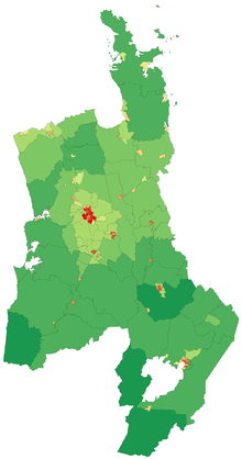
The region encompasses all or part of eleven territorial authorities, the most of any region of New Zealand. It is centred on the Waikato which consists of Waikato District, Matamata-Piako District, Waipa District, South Waikato District and Hamilton City.[3] In descending order of land area the eleven territorial authorities are Taupo District (part), Waikato District, Waitomo District (part), Thames-Coromandel District, Otorohanga District, South Waikato District, Matamata-Piako District, Waipa District, Hauraki District, Rotorua District (part), and Hamilton City.
The name for the region is taken from the Waikato River; waikato is a Māori word traditionally translated as "flowing water" (specifically, wai = "water" and kato = "the pull of the river current in the sea").[5]
When Waikato is used in spoken language it takes the definite article: the Waikato. But this usually refers to a smaller region than the Waikato local government region. Two definitions that would meet with wide acceptance are those of the Waikato rugby football union and of Hamilton Waikato tourism. The former takes in the local government areas of Hamilton City, the southern part of Waikato district, Waipa district, most of Matamata-Piako district and the South Waikato district.[6] Hamilton Waikato tourism takes in additionally the northern part of Waikato district (Tuakau and other centres), the northern King Country (Waitomo and Otorohanga districts), and the Te Aroha district.[7]
The parts of Waikato region beyond these limits are usually identified as Thames Valley and/or Hauraki/Coromandel (for the north-eastern part of Waikato region)[8] and Taupo, on the Volcanic or Central Plateau (for the south-eastern part of the region).[9]
Geography

To the west, the region is bounded by the Tasman Sea. The coastal region is largely rough hill country, known locally as the Hakarimata Range, though it is more gently undulating in the north, closer to the mouth of the Waikato River. The coast is punctured by three large natural harbours: Raglan Harbour, Aotea Harbour, and Kawhia Harbour. The area around Raglan is noted for its volcanic black sand beaches and for its fine surfing conditions at Manu Bay and Ruapuke beach.
To the east of the coastal hills lies the broad floodplain of the Waikato River. This region has a wet temperate climate, and the land is largely pastoral farmland created by European settlers draining the extensive natural swamps, although it also contains undrained peat swamp such as the 200km2 peat dome south of Ngatea. It is in the broad undulating Waikato Plains that most of the region's population resides, and the land is intensively farmed with both livestock, mainly dairy cattle but with sheep farming on the hillier west margins, and crops such as maize. The area around Cambridge has many thoroughbred stables.
The north of the region around Te Kauwhata produces some of New Zealand's best wines. Dozens of small shallow lakes lie in this area, the largest of which is Lake Waikare.
To the east, the land rises towards the forested slopes of the Kaimai and Mamaku Ranges. The upper reaches of the Waikato River are used for hydroelectricity, helped by several large artificial lakes in the region's south-east. The lowest and earliest-created such lake is Lake Karapiro, now developed as a world-class rowing centre, where the world championships were held in 2010. The river flows out of the country's largest lake, Lake Taupo, which is served by several important fishing rivers such as the Tongariro, on the Central Plateau, draining the eastern side of Mount Ruapehu and its neighbours.
The climate is mild and temperate with moderate rainfall of 1200–1600mm per annum, with the higher western hills having the most rain. Summers are drier with maximum temperatures of 25–28 degrees Celsius. Summer droughts occur one year in ten. Winter maxima are 12–15 degrees Celsius. The lower areas experience regular morning fog, under anticyclonic conditions, which burns off by late morning to produce many still, clear sunny days. Morning frosts are also common during winter anticyclones. Another distinctive feature is the low average wind speed in the interior basin due to the sheltering influence of the hills and mountains to the west and south-west. The prevailing winter wind is from the south-west. The Waikato has very high sunshine hours by world standards, averaging 2200 hours per year or about 40% higher than in the UK. This results in rapid growth of grass, crops and ornamental plants.
Demographics
Cities and towns
The largest city in the Waikato Region is Hamilton, with an urban and peri-urban population of 203,100 (June 2018).[2] It is home to the University of Waikato and the Waikato Institute of Technology (Wintec).
Other major towns in the region are Tokoroa, Te Awamutu, Cambridge and Taupo with respective populations of 14,050, 17,500, 20,600 and 24,700. (These populations include the urban and peri-urban areas). The region also includes the smaller towns of Huntly, Matamata, Morrinsville, Ngaruawahia, Otorohanga, Paeroa, Putaruru, Raglan, Te Aroha, Te Kauwhata, Te Kuiti, Thames, Tirau, Tuakau, Turangi, Whangamata and Whitianga.
| Urban area | Population (June 2018)[2] |
% of region |
|---|---|---|
| Hamilton | 203,100 | 43.3% |
| Taupo | 24,700 | 5.3% |
| Cambridge | 20,600 | 4.4% |
| Te Awamutu | 17,500 | 3.7% |
| Tokoroa | 14,050 | 3% |
| Huntly | 8,150 | 1.7% |
| Matamata | 7,920 | 1.7% |
| Morrinsville | 7,870 | 1.7% |
| Thames | 7,350 | 1.6% |
| Waihi | 5,150 | 1.1% |
| Whitianga | 5,080 | 1.1% |
| Te Kuiti | 4,640 | 1% |
| Paeroa | 4,410 | 0.9% |
| Te Aroha | 4,350 | 1% |
| Putaruru | 4,100 | 0.9% |
| Turangi | 3,320 | 0.7% |
| Raglan | 3,310 | 0.7% |
| Otorohanga | 2,750 | 0.6% |
| Te Kauwhata | 1,820 | 0.4% |
| Coromandel | 1,750 | 0.4% |
| Tairua | 1,430 | 0.3% |
| Ngatea | 1,420 | 0.3% |
Economy
The Waikato Region is the fourth largest regional economy in New Zealand after Auckland Region, Canterbury Region and Wellington Region. Gross regional product (GRP) for the year ended March 2007 was estimated to be $15,606 million compared with $12,493 million in March 2004.[10]
Between 2000 and 2004, Waikato economic growth was lower than the national average. But from 2004 to 2007, real gross regional product for the Waikato Region increased by 5 per cent per year compared with 3.2 per cent for the national average. This faster growth can be attributed to rapidly growing dairy and business services industries, facilitated by proximity to the Auckland city, the main international gateway for New Zealand.[10]
Given the suitable geography and climate, the Waikato economy is strongly based on agriculture, especially dairy. Dairy farming has been the main agricultural activity since the late nineteenth century. Within the Waikato region, small co-operative dairy companies where widespread during the 20th century. Towards the end of the 20th century, frequent mergers of co-operative dairy companies occurred, which ultimately ended in the formation of New Zealand wide dairy co-operative Fonterra in 2001. In 2007, dairy farming and dairy processing combined contributed $2 billion (13%) to GRP, which had risen to $2.4bn by 2014, but only 13,683 (7.6%) of jobs in 2016.[11] Business services is the second largest sector in the Waikato Region, contributing $1.2 billion or 8 per cent of GRP in 2007
Dairy farms are mainly family owned (2,608 of 4,020 farms in 2016) with owners employing sharemilkers in many cases (1,412 sharemilkers).[11] The size of the average dairy herd in the Waikato has progressively increased. It was about 320 cows in 2012[12] and in 2016 was about 351 (total Waikato herd 1.41m cows),[11] milked in either a herringbone or automated rotary cowshed so a large herd can be milked in under two hours. The cows are kept on grassland pasture all year due to the mild climate. In the Waikato the original English grasses used by earlier settlers – browntop, fescue and Yorkshire Fog – have been replaced with higher producing Italian ryegrass and nitrogen-fixing white clover. Farmers use a variety of supplementary feeds in winter or during the infrequent summer droughts. Main feeds are hay, grass silage and chopped corn feed. The later is often fed out on a concrete pad to save transportation and wastage by trampling.
History
Before the arrival of Europeans, the Waikato contained the third most densely populated part of New Zealand, after Northland/Auckland and the Bay of Plenty. The Waikato rohe (area) was inhabited by iwi (tribes) such as those of the Tainui confederation, including Waikato and Ngāti Toa who conquered the native inhabitants about 1450 according to Tainui historians, finally destroying them at a battle at Aratiatia. Between about 1750 and 1842 the area was subject to a large number of invasions by other Māori iwi and hapu confederations and large scale population migrations took place by a number of hapu and iwi. The largest battle ever fought in New Zealand took place near Ohaupo about 1790-1805, between two competing alliances of hapu. During the latter stages of this volatile period, known as the Musket Wars (1807–1845), conflict led to a migration south to Taranaki and eventually Kapiti Island.
In 1840 44 Waikato chiefs travelled north to the Manukau Heads and Manukau Harbour to sign the Treaty of Waitangi, officially making the Waikato area part of New Zealand. Three Ngati Maniapoto chiefs signed, as did three Ngati Haua chiefs but most signatories were Waikato. Chief Te Whero whero did not sign, "probably due to the lack of dignity compared to the Waitangi event". Unusually, the copy signed was in English.[13] Between 1840 and 1860 the CMS missionaries of the Anglican church assisted Waikato Maori in revolutionizing their economy in the Kihikihi area by the introduction of such crops as peaches, maize and wheat.
Missionaries brought in millers and helped Maori establish eight flour mills. These flourished until 1857, as they provided flour for the growing Auckland market in the 1850s and for a brief while were exporting to Australia. There were mills at Aotea, Kaitotehe, Karakariki, Kihikihi, Kirikiriroa, Kohanga, Kopatauaki, Mahoe, Mangaharakeke, Mangapapa, Mangarewarewa, Mangatawhiri, Matamata pā, Maungakawa, Maungatautari,[14] Mohoaonui,[15] Otawhao, Patetere, Rangataiki,[14] Rangiaowhia,[16] Taupo, Te Kopua, Te Rore, Tireke, Tuakau, Waitetuna, Whaingaroa[14] and Whatawhata.[17]
The route used to travel to and from Auckland was by dray to the Puniu stream, along the Waipa River to its junction with the Waikato. Near the Waikato Heads travellers entered the small Awaroa River. During summer it was necessary to push or pull the waka through to the Manukau Harbour at Waiuku. By 1850s a small bullock track had been established to Auckland via the settlements of Mauku, Drury, Papakura and Otahuhu or waka could take the sea route across the Manukau to Ihumatao (where Auckland International Airport is now).[18] The main tribe to use this route and the main traders were the Maniapoto tribe. They occupied an area of fertile land south of Te Awamutu at Kihikihi and Rangiaowhia. Maniapoto sold wheat, peaches, potatoes and other food to Auckland and bought back shirts, sugar, tobacco and rum.[19] The boom time ended in 1856-1857 with the end of the Australian gold rush, allowing importing of cheaper food, especially flour, from Australia. Even in the boom time of 1854-55, food grown by Waikato Maori, such as Ngati Maniapoto, was taken to the Auckland market in very small amounts compared to food from the Waiheke Island -Thames area. In early 1855 Ngati Maniapoto took only 3 canoes of potatoes to Auckland compared to 279 canoes containing a much wider variety of food from the Thames area.[20] Missionaries had also established schools for Maori. Benjamin and Harriet Ashwell ran a school for 50 Maori girls aged 6–17 at Taupiri in 1853. The girls had been at the school for up to 3 years and could read and write in English and do mental arithmetic.[21]
At the time of the Waikato campaign of 1863 against the rebel Māori King Movement forces, the population was estimated by the government at about 3,500 Māori.
During the late 1850s Maniapoto in particular become disgruntled in their dealings with Pakeha. They complained about the way they were treated in Auckland by traders but their chief compliant was that the government was underpaying them for land they were selling. The average price paid by government was 6d per acre but it was sold to settlers for 10/- per acre. The government argued that it had to pay for surveying and administration costs but to Maori it seemed unfair. Before the elevation of the first Maori king there was a wide range of opinions amongst influential Maori with some such as Wirimu Tamihana's father advocating supporting the Crown while Te Heuheu of Tuwharetoa advocated all out war against the government.[22] This view was initially unpopular as the king movement hoped to work alongside the crown. Maori were upset at the number of children that had been fathered by Pakeha, who had then disappeared. The children were left to be raised by their mothers with general hapu support. John Gorst, a well-educated government agent, reported significant numbers of half-caste children in the Waikato in the late 1850s. However, in the Ngati Maniapoto iwi at least 7 Pakeha integrated successfully with the tribe from 1842, marrying Maori women. The best known are William Searancke, who became an important government agent, and Frenchman Louis Hetet, who became a successful trader. Their half-caste children lived with the iwi, and some became leading figures.
What tipped the balance was conflict and criminal activity within the Waikato region. Influential chiefs said the treaty had promised the government would help maintain peace. They asked for government magistrates and courts. The government attempted to fulfill these requests but many of the young men who put themselves forward for the positions simply saw that they had an opportunity to get wealthy at the government's expense. This upset the older chiefs, who wanted the strong Maori leader Te Wherowhero to return from Mangere to his lands at Tamahere (South Hamilton) to rein in the out-of-control young chief magistrates.[23]
The Waikato has a prominent history, particularly regarding relationships between Māori and European in early colonial New Zealand. The Waikato was within the defined boundaries of the colonial provinces of New Ulster (1841–1853) and Auckland (1853–1876) but was principally Māori. During the land wars of the 1860s, the Waikato was the scene of five battles in what is referred to as the Invasion of the Waikato. In retaliation for the help Waikato Māori (mainly Ngāti Maniapoto) gave Taranaki Māori in their conflict over land in the earlier First Taranaki War, and the decision by some Waikato hapu to form a separate kingdom – the King Movement or Kingitanga – in opposition to the government, the colonial government, with the help of troops brought from Britain and Queenite Māori loyal to the Crown, pushed south from the main settlement of Auckland, fighting against Waikato raiders in Auckland before venturing into the Waikato to attack the combined hapu of the King Movement. During 1863 and 1864 fighting occurred at Pukekohe East, Titi hill, Burtts Farm, Galloway Redoubt, Kiri Kiri, Martyn's Farm, Patumahoe, Rhodes Clearing, Williamson's Clearing, Otau, Camerontown, Kakaramea and Wairoa ranges (all Auckland), Meremere, Rangiriri, Ngaruawahia, Rangiaowhia (southwest of Cambridge), Hairini Ridge and Ōrākau (near Kihikihi), all resulting in defeat for the Kingitanga forces. Eventually the rebel King Movement forces pulled back to positions in the area to the south of the Punui River in South Waikato, still known as the King Country, after 19 defeats by the British. Rewi's Last Stand, one of New Zealand's first motion pictures, in 1925, portrayed an entertaining, fictionalized version of the Ōrākau siege.
The headquarters of the Māori King Movement are now at Turangawaewae Marae at Ngaruawahia.
After the end of the war and the withdrawal of British and Australian troops, the region experienced a long period of economic recession after 1866. Most Maori had moved to the King Country and European settlers were more attracted to the South Island with its large gold discovery in Otago and the more easily farmed Canterbury Plains. The Waikato had poor land access and was not suitable for sheep farming which dominated livestock production in New Zealand until the 1890s invention of refrigeration. Dairying and the completion of the main trunk railway line at the turn of the century lead to a small, steady increase in population. After 1900 the Waikato continued to grow as a dairying region benefiting from the flow of capital earned from the sale of butter and cheese mainly to Britain.
Local government history
Following major floods in 1907,[24] a Waikato River Board was formed in 1911.[25] However, it was reported as ineffective in 1921[26] and ceased to operate,[27] though the need for a replacement was considered in 1933.[28]
Hauraki Catchment Board was set up in 1946.[24]
Major floods also occurred in 1953 and 1956.[24] Waikato Valley Authority was established by the Waikato Valley Authority Act on 26 October 1956. The Water and Soil Conservation Act 1967 extended it to become a Catchment/Regional Water Board.[29] The Ministry of Works and Development Abolition Act 1988, left WVA with that work[30] and it became the Waikato Catchment Board.[31]
The Waikato United Council, was formulated under the Local Government Act 1974, but due to objections excluded Thames/Coromandel district, though otherwise covered the present extent of the region.[32] It was set up under the Town and Country Planning Act 1977[24] and the Waikato Region Constitution Order 1980. WUC covered Hamilton City, Huntly, Ngaruawahia, Cambridge, Te Awamutu, Matamata, Putaruru and Tokoroa boroughs, Matamata, Raglan, Waikato, and Waipa counties, Otorohanga and Waitomo districts. It took over the Hamilton Regional Planning Authority and mainly dealt with regional planning and civil defence. By 1989, WUC had committees for regional planning, civil defence, regional government, and the Waikato Regional Development Board.[32] From 1987 it also included Thames-Coromandel District, Great Barrier Island, Hauraki Plains, Ohinemuri and Piako counties, and Morrinsville, Paeroa, Te Aroha and Waihi boroughs.[33]
On 1 November 1989 Waikato Regional Council was established[32] by the Local Government (Waikato Region) Reorganisation Order 1989.[34] from 40 former authorities:[30]- 2 catchment boards (Hauraki and Waikato),[30] 3 united councils (Waikato, Thames Valley[33] and part of Tongariro),[35] 12 noxious plants authorities, 11 pest destruction boards and 12 drainage boards.[30] The Land Transport Act 1998 added transport to WRC's responsibilities.[36] From 1 November 2010 Environment Waikato took over the southern parts of Franklin District.[37] That seems to be the only legislation naming it 'Environment Waikato', which had been its operating name[32] until 2011,[38] shortly after the 'Rates Control Team' won about half the seats in the 2010 election.[39]
Politics
In the 2010 local government elections, the Waikato Region had the country's lowest rate of returned votes, with only 30.8 per cent voting in the Waikato District Council elections and 33.6 per cent in Hamilton City.[40] Since then the percentage turnout has declined further[41] -
| Council | 2010 | 2013 | 2016 |
| Taupo District | 54.8 | 48.5 | 50.2 |
| Waitomo District | 49.0 | 43.6 | 38.4 |
| Rotorua District | 43.4 | 43.8 | 45.9 |
| Thames-Coromandel District | 43.8 | 37.8 | 38.0 |
| Hauraki District | 42.8 | 40.4 | 44.2 |
| Matamata-Piako District | 42.1 | 44.8 | 24.1 |
| South Waikato District | 39.1 | 41.5 | 44.4 |
| Waipa District | 41.8 | 39.6 | 38.7 |
| Otorohanga District | 36.4 | 50.6 | 25.1 |
| Hamilton City | 37.8 | 38.3 | 33.6 |
| Waikato District | 34.3 | 31.6 | 30.6 |
| National voter turnout % | 49.0 | 41.3 | 42.0 |
| Waikato Regional[42] | 42 | 40 |
People
The people of the Waikato use the nickname Mooloo to apply to themselves or to their region, particularly in relation to sporting endeavours. The word was likely first applied to the Waikato provincial rugby team. Its origin is related to the mascot of a pantomime-like milking cow used in parades, public events and sports matches — particularly rugby, reflecting the importance of the dairy industry to the region. Waikato hosts the Chiefs Super Rugby team and Waikato Mitre 10 Cup rugby team at Waikato Stadium and the Northern Districts Knights in domestic cricket at Seddon Park, both in Hamilton.
Notable people
- Jim Bolger — former Prime Minister of New Zealand
- Roy Calvert — WWII pilot
- Helen Clark — former Prime Minister of New Zealand
- Don Clarke — rugby international
- The Datsuns — rock band
- Tim and Neil Finn — songwriters and musicians (Split Enz, Crowded House)
- Rob Hamill — champion rower and author.
- Te Puea Herangi — Māori princess and leader
- Rangimarie Hetet — of Oparure Marae. Died aged 103 years; regarded as living treasure of Māori handcrafts, with honorary degrees.
- Kimbra — notable New Zealand singer-songwriter/guitarist
- Dame Malvina Major — acclaimed international singer
- Bruce McLaren — motor racing driver and team founder
- Colin Meads — rugby international
- Anjali Thakker — New Zealand ice and inline hockey player
- Tawera Nikau — rugby league footballer and sports broadcaster
- Tuheitia Paki — Māori King 2006–present
- Simon Poelman — New Zealand decathlete
- Eva Rickard — of Tainui descent; leader and defender of Māori land rights
- Hilda Ross — humanitarian, first woman elected to the Hamilton Borough Council, MP
- Frank Sargeson — celebrated NZ writer.
- Maurice Shadbolt — celebrated New Zealand writer
- Peter Snell, gold medal winning distance runner at the 1964 Olympics
- Te Atairangikaahu — Māori Queen 1966-2006
- Te Rauparaha — Māori chieftain and warrior
- Wiremu Tamihana Tarapipipi Te Waharoa — Māori King kingmaker
- Dame Catherine Tizard (née Mclean) — former Mayor of Auckland and first woman Governor-General of New Zealand
- Mark Todd — Olympic equestrian, "Horseman of the Century"
- Jools and Lynda Topp — comedy duo
- Daniel Vettori — former New Zealand cricket captain
References
- ↑ Smallman, Elton Rikihana (20 October 2016). "Alan Livingston voted chairman of Waikato Regional Council". Waikato Times.
- 1 2 3 4 "Subnational Population Estimates: At 30 June 2018 (provisional)". Statistics New Zealand. 23 October 2018. Retrieved 23 October 2018. For urban areas, "Subnational population estimates (UA, AU), by age and sex, at 30 June 1996, 2001, 2006-18 (2018 boundary)". Statistics New Zealand. 23 October 2018. Retrieved 23 October 2018.
- 1 2 Swarbrick, Nancy (3 June 2010). "Waikato region – Overview". Te Ara – the Encyclopedia of New Zealand. Retrieved 10 July 2011.
- ↑ "About the Waikato region". Waikato Regional Council. Retrieved 2011-05-11.
- ↑ Royal, Te Ahukaramū Charles (3 May 2010). "Waikato tribes – Waikato landmarks". Te Ara – the Encyclopedia of New Zealand. Retrieved 10 July 2011.
- ↑ "Waikato Rugby Union : Official Website". www.mooloo.co.nz. Retrieved 16 March 2018.
- ↑ "Hamilton & Waikato Visitor Information". hamiltonwaikato.com. Retrieved 16 March 2018.
- ↑ Taonga, New Zealand Ministry for Culture and Heritage Te Manatu. "Hauraki–Coromandel". teara.govt.nz. Retrieved 16 March 2018.
- ↑ Taonga, New Zealand Ministry for Culture and Heritage Te Manatu. "Volcanic Plateau". teara.govt.nz. Retrieved 16 March 2018.
- 1 2 "2009 Waikato Economic Report". Waikato Regional Council. 2009. Retrieved 18 February 2010.
- 1 2 3 "QuickStats about dairying – WAIKATO REGION" (PDF). DairyNZ Economics Group. June 2016.
- ↑ "Archived copy" (PDF). Archived from the original (PDF) on 9 February 2013. Retrieved 14 August 2012.
- ↑ NZ History. Waikato -Manakau Treaty copy. Updated 19 Feb. 2016.
- 1 2 3 "Journal of the Polynesian Society: Maori Flour Mills Of The Auckland Province, 1846-1860, By R. P. Hargreaves, P 227-232". www.jps.auckland.ac.nz. Retrieved 2017-04-23.
- ↑ "WHEAT FIELDS AGAIN. (Northern Advocate, 1931-05-30)". paperspast.natlib.govt.nz National Library of New Zealand. Retrieved 2017-04-23.
- ↑ "Chapter III — Plough and Flour-Mill. | NZETC". nzetc.victoria.ac.nz. Retrieved 2017-04-23.
- ↑ "KORERO O TE POITINI TE KAI TITIRO I NGA MIRA MAORI. (Maori Messenger : Te Karere Maori, 1855-12-01)". paperspast.natlib.govt.nz National Library of New Zealand. Retrieved 2017-04-23.
- ↑ J. Gorst. The Maori King, P11 and Map. Reed. 2001.
- ↑ J. Gorst. The Maori King. P13. Reed 2001
- ↑ Maori Enterprise to c1860. Hazel Petrie.
- ↑ The Voyagers.P Moon. p 62. Penguin 2014.
- ↑ J Gorst. The Maori King p 34, 35, 40. Reed 2001.
- ↑ J Gorst. The Maori King. P 39-49. Reed 2001.
- 1 2 3 4 Poole, A. L. (1983). "Catchment Control in New Zealand" (PDF). NIWA.
- ↑ "WAIKATO RIVER BOARD. (New Zealand Herald, 1911-09-19)". paperspast.natlib.govt.nz National Library of New Zealand. Retrieved 2017-06-02.
- ↑ "WAIKATO RIVER BOARD (Waikato Times, 1921-12-12)". paperspast.natlib.govt.nz National Library of New Zealand. Retrieved 2017-06-02.
- ↑ "MINISTER ON TOUR. (New Zealand Herald, 1926-10-15)". paperspast.natlib.govt.nz National Library of New Zealand. Retrieved 2017-06-02.
- ↑ "THE WAIKATO RIVER (New Zealand Herald, 1933-08-17)". paperspast.natlib.govt.nz National Library of New Zealand. Retrieved 2017-06-02.
- ↑ "Soil Conservation and Rivers Control Amendment Act 1988 No 48, Public Act 42 Repeal of Waikato Valley Authority Act 1956 – New Zealand Legislation". www.legislation.govt.nz. Retrieved 2017-06-02.
- 1 2 3 4 "The work we do". Waikato Regional Council. Retrieved 2017-06-02.
- ↑ "Soil Conservation and Rivers Control Amendment Act 1988 No 48, Public Act – New Zealand Legislation". www.legislation.govt.nz. Retrieved 2017-06-02.
- 1 2 3 4 "Waikato United Council | The Community Archive". thecommunityarchive.org.nz. Retrieved 2017-06-02.
- 1 2 "Local Government Amendment Act 1987" (PDF). New Zealand Legal Information Institute.
- ↑ Taonga, New Zealand Ministry for Culture and Heritage Te Manatu. "Waikato local government". www.teara.govt.nz. Retrieved 2017-06-02.
- ↑ Central, Archives. "Tongariro United Council (mixed)". archivescentral.org.nz. Retrieved 2017-06-02.
- ↑ "Land Transport Act 1998 No 110 (as at 01 October 2007), Public Act 178 Regional land transport committees – New Zealand Legislation". www.legislation.govt.nz. Retrieved 2017-06-02.
- ↑ "Local Government (Auckland Transitional Provisions) Act 2010 No 37 (as at 01 March 2017), Public Act – New Zealand Legislation". www.legislation.govt.nz. Retrieved 2017-06-02.
- ↑ "Public blasts name change". Stuff.co.nz. 2011-04-06. Retrieved 2017-06-02.
- ↑ Adams, By Daniel (2010-10-09). "Rates control popular for Environment Waikato". Stuff.co.nz. Retrieved 2017-06-02.
- ↑ Harper, Paul (15 October 2010). "Voter turnout up in local elections". The New Zealand Herald. Retrieved 16 October 2010.
- ↑ "Final voter turnout 2016". www.lgnz.co.nz. Retrieved 2016-10-27.
- ↑ "Voter turnout". www.waikatoregion.govt.nz. Retrieved 2016-10-27.
External links
| Wikimedia Commons has media related to Waikato Region. |
| Look up waikato in Wiktionary, the free dictionary. |
| North Island | ||
|---|---|---|
| South Island | ||
* Governed by a unitary authority rather than a regional council | ||