Villeta Group
| Villeta Group Stratigraphic range: Aptian-Coniacian ~125–87 Ma | |
|---|---|
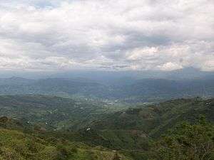 Villeta, type locality of the Villeta Group | |
| Type | Geological group |
| Sub-units | Conejo Fm., La Frontera Fm., Simijaca Fm., Hiló Fm., Pacho Fm., Chiquinquirá Sst., Capotes Fm., Socotá Fm., El Peñón Fm., Trincheras Fm. |
| Underlies | Guadalupe Group |
| Overlies | La Naveta Formation |
| Lithology | |
| Primary | Sandstone, shale, limestone |
| Location | |
| Coordinates | 5°00′59″N 74°28′54″W / 5.01639°N 74.48167°WCoordinates: 5°00′59″N 74°28′54″W / 5.01639°N 74.48167°W |
| Region |
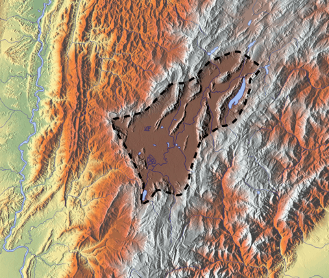
Altiplano Cundiboyacense Eastern Ranges, Andes |
| Country |
|
| Type section | |
| Named for | Villeta |
| Named by | Hettner |
| Year defined | 1892 |
| Coordinates | 4°35′31″N 74°03′15″W / 4.59194°N 74.05417°W |
| Region | Cundinamarca, Boyacá, Huila, Santander |
| Country |
|
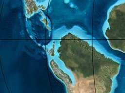
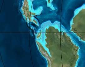 Paleogeography of northern South America 105 Ma, by Ron Blakey | |
The Villeta Group (Spanish: Grupo Villeta) is a geological group of the Eastern Ranges of the Colombian Andes, to the west of the Altiplano Cundiboyacense. The group, a sequence of shales, limestones and sandstones, is subdivided into various formations; Conejo, La Frontera, Simijaca, Hiló, Pacho, Chiquinquirá, Capotes, Socotá, El Peñón, and Trincheras, and dates to the Cretaceous period; Aptian-Coniacian epochs. The group stretches out across four departments, from Huila in the south, through Cundinamarca and Boyacá to southern Santander in the north. The upper part of the Villeta Group is time-equivalent with the La Luna Formation of the Middle Magdalena Valley (VMM) and Sierra Nevada del Cocuy, the Oliní and Güagüaquí Groups of the Guaduas-Vélez synclinal and the Chipaque Formation of the Altiplano Cundiboyacense. The lower part has been correlated with the Simití, Tablazo and Paja Formations of the VMM, the upper Tibasosa, Une and Fómeque Formations of the Altiplano Cundiboyacense and the Capacho, Aguardiente, Tibú-Mercedes and upper Río Negro Formations of the Sierra Nevada del Cocuy.
Etymology
The group was published in 1892 by Hettner and named after its type locality Villeta on the western flanks of the Eastern Ranges of the Colombian Andes.[1]
Description
Lithologies
The sequence comprises an alternation of sandstones, shales and limestones and the lithologies and lateral facies variations are described in detail in the various formations comprising the group. Mineralizations of zinc, cadmium and molybdenum have been found in the Villeta Group.[2]
Stratigraphy and depositional environment
The Villeta Group overlies the La Naveta Formation and is overlain by the Guadalupe Group. The age has been estimated to be Aptian-Coniacian and the unit is subdivided into the Conejo, La Frontera, Simijaca, Hiló, Pacho Formations, the Chiquinquirá Sandstone, and the Capotes, Socotá, El Peñón, and Trincheras Formations. The core extent of the group has been defined by Cáceres and Etayo in 1969, running from Apulo in the south to Muzo in the north.[1][3] The Villeta Group has been deposited in a marine environment and the organic rich shales and pelagic limestones and cherts of the Villeta Group and equivalent units comprise 60-70% of the Cretaceous record in the Eastern Ranges. They provide a good opportunity to study the interactions between tectonics eustatic sea level and sedimentation that regulate relative sea level in a basin.[4]
Outcrops
The formations of the Villeta Group are apart from its type locality near Villeta, found in other parts of the western flanks of the Eastern Ranges, stretching from Huila in the south to southern Santander in the north.[5][6][7][8][9][10][11][12][13][14][15]
Regional correlations
See also
References
- 1 2 Acosta & Ulloa, 2002, p.39
- ↑ Acosta & Ulloa, 2001, p.14
- ↑ Acosta & Ulloa, 2001, p.22
- ↑ Villamil, 2012, p.161
- ↑ Plancha 170, 2009
- ↑ Plancha 171, 2009
- ↑ Plancha 190, 2009
- ↑ Plancha 191, 1998
- ↑ Plancha 209, 2009
- ↑ Plancha 210, 2010
- ↑ Plancha 227, 1998
- ↑ Plancha 245, 1999
- ↑ Plancha 246, 1998
- ↑ Plancha 264, 2000
- ↑ Plancha 265, 1999
Bibliography
- Acosta, Jorge E., and Carlos E. Ulloa. 2002. Mapa geológico del Departamento de Cundinamarca 1:250,000 - Memoria Explicativa, 1-108. INGEOMINAS.
- Acosta Garay, Jorge, and Carlos E. Ulloa Melo. 2001. Geología de la Plancha 208 Villeta - 1:100,000, 1-84. INGEOMINAS. Accessed 2018-05-12.
- Villamil, Tomas. 2012. Chronology Relative Sea Level History and a New Sequence Stratigraphic Model for Basinal Cretaceous Facies of Colombia, 161–216. Society for Sedimentary Geology (SEPM).
Maps
- Ulloa, Carlos E, and Erasmo Rodríguez. 2009. Plancha 170 - Vélez - 1:100,000, 1. INGEOMINAS. Accessed 2017-06-06.
- Renzoni, Giancarlo, and Humberto Rosas. 2009. Plancha 171 - Duitama - 1:100,000, 1. INGEOMINAS. Accessed 2017-06-06.
- Fuquen M., Jaime A, and José F. Osorno M. 2009. Plancha 190 - Chiquinquirá - 1:100,000, 1. INGEOMINAS. Accessed 2017-06-06.
- Renzoni, Giancarlo; Humberto Rosas, and Fernando Etayo Serna. 1998. Plancha 191 - Tunja - 1:100,000, 1. INGEOMINAS. Accessed 2017-06-06.
- Ulloa, Carlos, and Jorge Acosta. 1998. Plancha 208 - Villeta - 1:100,000, 1. INGEOMINAS. Accessed 2017-06-06.
- Montoya, Diana María, and Germán Reyes. 2009. Plancha 209 - Zipaquirá - 1:100,000, 1. INGEOMINAS. Accessed 2017-06-06.
- Terraza, Roberto; Giovanni Moreno; José A. Buitrago; Adrián Pérez, and Diana María Montoya. 2010. Plancha 210 - Guateque - 1:100,000, 1. INGEOMINAS. Accessed 2017-06-06.
- Ulloa, Carlos E; Erasmo Rodríguez, and Jorge E. Acosta. 1998. Plancha 227 - La Mesa - 1:100,000, 1. INGEOMINAS. Accessed 2017-06-06.
- Acosta, Jorge E.; Rafael Guatame; Oscar Torres, and Frank Solano. 1999. Plancha 245 - Girardot - 1:100,000, 1. INGEOMINAS. Accessed 2017-06-06.
- Acosta, Jorge E., and Carlos E. Ulloa. 1998. Plancha 246 - Fusagasugá - 1:100,000, 1. INGEOMINAS. Accessed 2017-06-06.
- Calcedo, Juan Carlos, and Roberto Terraza. 2000. Plancha 264 - Espinal - 1:100,000, 1. INGEOMINAS. Accessed 2017-06-06.
- Acosta, Jorge; Juan Carlos Calcedo, and Carlos Ulloa. 1999. Plancha 265 - Icononzo - 1:100,000, 1. INGEOMINAS. Accessed 2017-06-06.