Loma Gorda Formation
| Loma Gorda Formation Stratigraphic range: Turonian-Coniacian ~90–86.3 Ma | |
|---|---|
| Type | Geological formation |
| Unit of | Güagüaquí Group |
| Underlies | Oliní Group |
| Overlies | Hondita Formation |
| Thickness | up to 167 m (548 ft) |
| Lithology | |
| Primary | Siltstone, shale |
| Other | Calcareous concretions |
| Location | |
| Coordinates | 4°15′37.5″N 74°43′28.7″W / 4.260417°N 74.724639°WCoordinates: 4°15′37.5″N 74°43′28.7″W / 4.260417°N 74.724639°W |
| Region | Upper Magdalena Valley, Central & Eastern Ranges, Andes |
| Country |
|
| Type section | |
| Named for | Loma Gorda ("Fat Hill") |
| Named by | De Porta |
| Location | Ricaurte, Cundinamarca |
| Year defined | 1966 |
| Coordinates | 4°15′37.5″N 74°43′28.7″W / 4.260417°N 74.724639°W |
| Region | Cundinamarca, Huila, Tolima |
| Country |
|
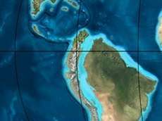
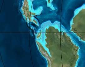
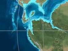
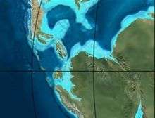
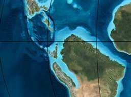 Paleogeography of Northern South America 90 Ma, by Ron Blakey | |
The Loma Gorda Formation (Spanish: Formación Loma Gorda, Kl, Kslg) is a fossiliferous geological formation of the Upper Magdalena Valley (VSM) and surrounding Central and Eastern Ranges of the Colombian Andes, extending from Cundinamarca in the north to Huila and easternmost Tolima in the south. The uppermost unit of the Güagüaquí Group, a sequence of laminated siltstones and shales, dates to the Late Cretaceous period; Turonian to Coniacian epochs, and has a maximum thickness of 167 metres (548 ft).
Etymology
The formation was named in 1966 by De Porta, named Loma Gorda ("Fat Hill") in Ricaurte, Cundinamarca.[1]
Description
Lithologies
The Loma Gorda Formation is characterised by laminated siltstones and shales with calcareous concretions.[2] The formation has provided fossils of Ankinatsytes venezolanus, Barroisiceras onilahyense, Codazziceras ospinae, Eulophoceras jacobi, Fagesia catinus, Hauericeras madagascarensis, Hoplitoides ingens, H. lagiraldae, Mitonia gracilis, Mytiloides kossmati, M. goppelnensis, M. scupini, Neoptychites cf. andinus, Paralenticeras sieversi, Paramammites sp., Peroniceras subtricarinatum, Prionocycloceras guayabanum, Reesidites subtuberculatum, Subprionotropis colombianus, Allocrioceras sp., Anagaudryceras sp., Anomia sp., Benueites sp., Choffaticeras sp., Dydimotis sp., Forresteria sp., Gauthiericeras sp., Morrowites sp., Nannovascoceras sp., and Quitmaniceras sp..[3]
Stratigraphy and depositional environment
The Loma Gorda Formation is the uppermost unit of the Güagüaquí Group.[1] It overlies the Hondita Formation and is overlain by the Oliní Group. The age has been estimated on the basis of ammonites to be ranging from Turonian to Coniacian.[2] Stratigraphically, the formation is time equivalent with the upper parts of the Chipaque, La Luna and La Frontera Formations.[4] The formation was deposited in a relative highstand sequence with an oceanic oxygen depletion event, sharply marked in Colombia and characterised by the appearance of calcareous concretions with a thick pyrite rim.[5]
Outcrops
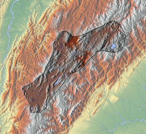
The type locality of the Loma Gorda Formation is located close to Loma Gorda in Ricaurte, Cundinamarca.[6] Other outcrops of the Loma Gorda Formation have been noted east of the Magdalena River northeast of Honda,[7] west of Nariño, [8] west across the Magdalena River in San Luis, Tolima,[9] between the Tetuán and Saldaña Rivers west of Coyaima and east and west of Ataco,[10] to the east of the Prado River reservoir,[11] north and west of Aipe,[12] surrounding Alpujarra, Tolima,[13] south of Palermo, Huila, displaced by the Baché Fault,[14] east of Iquira,[15] north of Yaguará,[16] south of La Plata where the formation is cut by the Itaibe Fault,[17] a small patch east of Gigante, Huila,[18] northwest and northeast of San Agustín,[19] and north of Timaná surrounding the Magdalena River.[20]
Regional correlations
See also
References
- 1 2 Acosta & Ulloa, 2002, p.23
- 1 2 Acosta & Ulloa, 2002, p.24
- ↑ Patarroyo, 2011
- ↑ Acosta & Ulloa, 2002, p.22
- ↑ Villamil, 2012, p.173
- ↑ Acosta & Ulloa, 2001, p.43
- ↑ Plancha 207, 2010
- ↑ Plancha 245, 1999
- ↑ Plancha 264, 2002
- ↑ Plancha 282, 1993
- ↑ Plancha 283, 2009
- ↑ Plancha 302, 1993
- ↑ Plancha 303, 2002
- ↑ Plancha 323, 1998
- ↑ Plancha 344, 1999
- ↑ Plancha 345, 1999
- ↑ Plancha 366, 1998
- ↑ Plancha 367, 2003
- ↑ Plancha 388, 2002
- ↑ Plancha 389, 2003
Bibliography
- Acosta, Jorge E., and Carlos E. Ulloa. 2002. Mapa geológico del Departamento de Cundinamarca 1:250,000 - Memoria Explicativa, 1–108. INGEOMINAS.
- Patarroyo, Pedro. 2011. Sucesión de Amonitas del Cretácico Superior (Cenomaniano-Coniaciano) de la parte más alta de la Formación Hondita y de la Formación Loma Gorda en la Quebrada Bambucá, Aipe - Huila (Colombia). Boletín de Geología, Universidad Nacional de Colombia 33. 69–92. Accessed 2017-03-31.
- Villamil, Tomas. 2012. Chronology Relative Sea Level History and a New Sequence Stratigraphic Model for Basinal Cretaceous Facies of Colombia, 161–216. Society for Sedimentary Geology (SEPM).
Maps
- Barrero L., Darío, and Carlos J. Vesga O. 2009. Plancha 188 - La Dorada - 1:100,000, 1. INGEOMINAS. Accessed 2017-06-06.
- Barrero, Darío, and Carlos J. Vesga. 2010. Plancha 207 - Honda - 1:100,000, 1. INGEOMINAS. Accessed 2017-06-06.
- Acosta, Jorge E.; Rafael Guatame; Oscar Torres, and Frank Solano. 1999. Plancha 245 - Girardot - 1:100,000, 1. INGEOMINAS. Accessed 2017-06-06.
- Calcedo, Juan Carlos, and Roberto Terraza. 2000. Plancha 264 - Espinal - 1:100,000, 1. INGEOMINAS. Accessed 2017-06-06.
- Carvajal, Cesar; Jaime Fuquen, and Luis Gómez. 1993. Plancha 282 - Chaparral - 1:100,000, 1. INGEOMINAS. Accessed 2017-06-06.
- Cossio, Ubaldo; Gabriel Rodríguez, and Miguel Rodríguez. 1995. Plancha 283 - Purificación - 1:100,000, 1. INGEOMINAS. Accessed 2017-06-06.
- Fuquen, Jaime; Gabriel Rodríguez; Ubaldo Cossio, and Alberto Núñez. 1993. Plancha 302 - Aipe - 1:100,000, 1. INGEOMINAS. Accessed 2017-06-06.
- Acosta, Jorge; Pablo Caro; Jaime Fuquen, and José Osorno. 2002. Plancha 303 - Colombia - 1:100,000, 1. INGEOMINAS.
- Ferreira, Paulina; Alberto Núñez, and Miguel Rodríguez. 1998. Plancha 323 - Neiva - 1:100,000, 1. INGEOMINAS. Accessed 2017-06-06.
- Marquínez, Germán; C. Morales, and Alberto Núñez. 1999. Plancha 344 - Tesalia - 1:100,000, 1. INGEOMINAS. Accessed 2017-06-06.
- Velandia, F.; C.J. Morales; J.C. Caicedo, and Alberto Núñez. 1999. Plancha 345 - Campoalegre - 1:100,000, 1. INGEOMINAS. Accessed 2017-06-06.
- Marquínez, Germán; Yohana Rodríguez; Roberto Terraza, and Mario Martínez. 2003. Plancha 365 - Coconuco - 1:100,000, 1. INGEOMINAS. Accessed 2017-06-06.
- Rodríguez, Gabriel; Paulina Ferreira; Francisco Velandia, and Alberto Núñez. 1998. Plancha 366 - Garzón - 1:100,000, 1. INGEOMINAS. Accessed 2017-06-06.
- Rodríguez, Gabriel; Gilberto Zapata, and M. Velázquez. 2003. Plancha 367 - Gigante - 1:100,000, 1. INGEOMINAS. Accessed 2017-06-06.
- Cárdenas, Jorge; Jaime Fuquen, and Alberto Núñez. 20002. Plancha 388 - Pitalito - 1:100,000, 1. INGEOMINAS. Accessed 2017-06-06.
- Rodríguez, Gabriel; Gilberto Zapata, and M. Velázquez. 2003. Plancha 389 - Timaná - 1:100,000, 1. INGEOMINAS. Accessed 2017-06-06.
External links
- Gómez, J.; N.E. Montes; Á. Nivia, and H. Diederix. 2015. Plancha 5-09 del Atlas Geológico de Colombia 2015 – escala 1:500,000, 1. Servicio Geológico Colombiano. Accessed 2017-03-16.