Villeta, Cundinamarca
| Villeta | |||
|---|---|---|---|
| Municipality and town | |||
 Bocatoma waterfall in Villeta | |||
| |||
 Location of Villeta in Cundinamarca | |||
 Villeta Location in Colombia | |||
| Coordinates: 5°0′29.91″N 74°28′25.61″W / 5.0083083°N 74.4737806°WCoordinates: 5°0′29.91″N 74°28′25.61″W / 5.0083083°N 74.4737806°W | |||
| Country |
| ||
| Department |
| ||
| Province | Gualivá | ||
| Founded | 29 September 1551 | ||
| Founded by | Alonso de Olalla & Hernando de Alcocer | ||
| Government | |||
| • Mayor |
Jhon Alexander Morera Gutiérrez (2016-2019) | ||
| Area | |||
| • Total | 140.7 km2 (54.3 sq mi) | ||
| Elevation | 850 m (2,790 ft) | ||
| Population (2015) | |||
| • Total | 25,164 | ||
| • Density | 180/km2 (460/sq mi) | ||
| Time zone | UTC-5 (Colombia Standard Time) | ||
| Website | Official website | ||
.svg.png)
Villeta is a municipality and town in Cundinamarca (Colombia), located in Gualivá Province, approximately 84 kilometres (52 mi) northwest of Bogota, considered the capital of the province. Its name means "Little Village". The municipality borders Quebradanegra and Nimaima in the north, Nocaima and Sasaima in the east, Albán and Vianí in the south and Guaduas in the west. It is situated at an altitude of 850 metres (2,790 ft) in the Eastern Ranges of the Colombian Andes[1]
History
The region of Villeta before the Spanish conquest was inhabited by the Panche. Modern Villeta was founded as Villa de San Miguel on September 29, 1551 by Alonso de Olalla and Hernando de Alcocer.[2]
Main economic activities in Villeta are related with sugar cane derivatives and as an important tourist center for people from Bogotá due to its warm climate, including ecologic trails, cascades and hotels.
Geology
The Villeta Group comprising the Conejo, La Frontera, Simijaca, Hiló, Capotes, Socotá, El Peñón and Trincheras Formations is named after Villeta.[3]
Gallery
 Old house
 Church interior
 Monument to the farmers
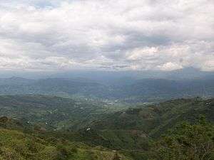 Landscape of Villeta
References
| Wikimedia Commons has media related to Villeta, Cundinamarca. |
- ↑ Official website Villeta
- ↑ History Villeta
- ↑ Acosta & Ulloa, 2001, p.39
Bibliography
- Acosta Garay, Jorge E., and Carlos E. Ulloa Melo. 2002. Mapa Geológico del Departamento de Cundinamarca - 1:250,000 - Memoria explicativa, 1–108. INGEOMINAS. Accessed 2017-04-26.
- Acosta Garay, Jorge, and Carlos E. Ulloa Melo. 2001. Geología de la Plancha 208 Villeta - 1:100,000, 1-84. INGEOMINAS. Accessed 2017-06-05.