Chiquinquirá
| Chiquinquirá | |||
|---|---|---|---|
| Municipality and town | |||
 View of Chiquinquirá | |||
| |||
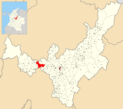 Location of the municipality and town of Chiquinquirá in the Boyacá Department of Colombia. | |||
 Chiquinquirá Location in Colombia | |||
| Coordinates: 5°37′08″N 73°49′12″W / 5.61889°N 73.82000°W | |||
| Country |
| ||
| Department | Boyacá Department | ||
| Province | Western Boyacá Province | ||
| Founded | never | ||
| Government | |||
| • Mayor |
Cesar Augusto Carrillo Ortegón (2016-2019) | ||
| Area | |||
| • Total | 133 km2 (51 sq mi) | ||
| Elevation | 2,556 m (8,386 ft) | ||
| Population (2015) | |||
| • Total | 72,274 | ||
| • Density | 540/km2 (1,400/sq mi) | ||
| Demonym(s) | Chiquinquireño | ||
| Time zone | UTC-5 (Colombia Standard Time) | ||
| Postal code | 154640-49 | ||
| Area code(s) | 57 + 8 | ||
| Website | Official website | ||


Chiquinquirá is a town and municipality in the Colombian Department of Boyacá,[1] part of the subregion of the Western Boyacá Province. Located some 115 km north of Bogotá, Chiquinquirá is 2,556 metres (8,386 ft) above sea level and has a yearly average temperature 58 °F (14 °C)
Etymology
The name Chiquinquirá comes from Chibcha and means "Place of swamps covered with fog".[2]
Geography and religion
Chiquinquirá is constituted by two zones: the urban zone or town which is formed by approximately 40 neighbourhoods between the strata 1 and 4, and the rural zone which is divided in 17 sub zones located around the city.
It is home to the Basílica de Chiquinquirá, which houses the image of the Virgen de Chiquinquirá, the patroness saint of Colombia. Chiquinquirá is a major point of religious pilgrimage (source: Colombia Lonely Planet Guide, 2nd Edition, 1995).
History
The area of Chiquinquirá used to be inhabited by the Muisca before the Spanish conquest and Chiquiquinrá was an important place in the Chiquinquirá Valley. It was ruled by an independent cacique within the Muisca Confederation. It was never properly founded as a municipality.[3]
In November, 1967, 81 people in Chiquinquirá, most of them children, were fatally poisoned and hundreds more became seriously ill after eating bread that had been made with flour that had been contaminated with a powdered insecticide. [4] [5]
Murder charges would later be filed against a Bogotá truck driver who had delivered the flour and the owner of the bakery that had baked and sold the bread to local residents. [6]
Geology
The Chiquinquirá Sandstone is named after the town.
Gallery
 Cultural centre
 David Guarín Park
 Church
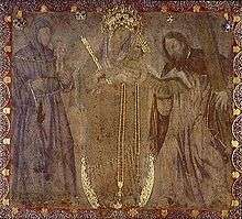 Painting of the Virgin Mary
References
- ↑ "Alcaldía de Chiquinquirá - Boyacá". Gobierno en Línea.net. Archived from the original on 15 May 2006. Retrieved 30 August 2011.
- ↑ (in Spanish) Etymology Chiquinquirá - Excelsio.net
- ↑ (in Spanish) Official website Chiquinquirá
- ↑ "Impure Bread Is Fatal to 75", Chicago Tribune, November 26, 1967, p1
- ↑ "74 Muertos en Chiquinquirá", El Tiempo (Bogotá), November 26, 1967, p1
- ↑ "Colombia Files Murder Charges in Poison Deaths", Star Tribune (Minneapolis, MN), December 10, 1967, p26B
Coordinates: 5°38′N 73°45′W / 5.633°N 73.750°W