Apulo
| Apulo | ||
|---|---|---|
| Municipality and town | ||
| ||
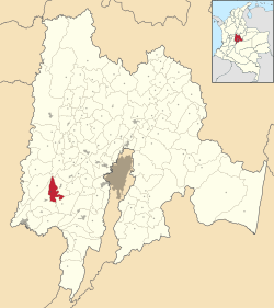 Location of the municipality and town inside Cundinamarca Department of Colombia | ||
 Apulo Location in Colombia | ||
| Coordinates: 4°31′15″N 74°35′55″W / 4.52083°N 74.59861°WCoordinates: 4°31′15″N 74°35′55″W / 4.52083°N 74.59861°W | ||
| Country |
| |
| Department |
| |
| Area | ||
| • Total | 122 km2 (47 sq mi) | |
| Elevation | 420 m (1,380 ft) | |
| Population (2015) | ||
| • Total | 7,812 | |
| • Density | 64/km2 (170/sq mi) | |
| Time zone | UTC-5 (Colombia Standard Time) | |
.svg.png)
Apulo (previously called Rafael Reyes Municipality) is a Colombian town and municipality in the Cundinamarca Department.
This article is issued from
Wikipedia.
The text is licensed under Creative Commons - Attribution - Sharealike.
Additional terms may apply for the media files.