Simijaca Formation
| Simijaca Formation Stratigraphic range: Cenomanian-Turonian ~100–90 Ma | |
|---|---|
| Type | Geological formation |
| Unit of | Villeta Group |
| Underlies | La Frontera Formation |
| Overlies | Chiquinquirá Sst., Churuvita Fm., Hiló Fm., Pacho Fm. |
| Thickness | up to 693 m (2,270 ft) |
| Lithology | |
| Primary | Mudstone |
| Other | Shale, sandstone, limestone |
| Location | |
| Coordinates | 5°29′15″N 73°50′55″W / 5.48750°N 73.84861°WCoordinates: 5°29′15″N 73°50′55″W / 5.48750°N 73.84861°W |
| Region |
Altiplano Cundiboyacense Eastern Ranges, Andes |
| Country |
|
| Type section | |
| Named for | Simijaca |
| Named by | Ulloa & Rodríguez |
| Location | South of Simijaca |
| Year defined | 1991 |
| Coordinates | 5°29′15″N 73°50′55″W / 5.48750°N 73.84861°W |
| Region | Cundinamarca, Boyacá |
| Country |
|
| Thickness at type section | 432 metres (1,420 ft) |
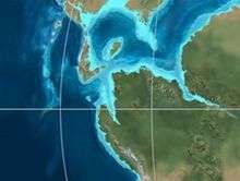
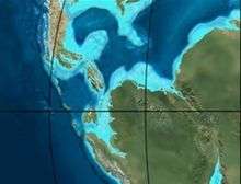
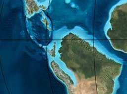 Paleogeography of Northern South America 90 Ma, by Ron Blakey | |
The Simijaca Formation (Spanish: Formación Simijaca, K2S, Kss) is a geological formation of the Altiplano Cundiboyacense, Eastern Ranges of the Colombian Andes. The predominantly mudstone formation dates to the Late Cretaceous period; Turonian and Cenomanian epochs, and has a maximum thickness of 693 metres (2,274 ft).
Etymology
The formation was defined and named in 1991 by Ulloa and Rodríguez after Simijaca, Cundinamarca.[1]
Description
Lithologies
The Simijaca Formation is characterised by a sequence of mudstones, grey and black shales with sandstone and limestone intercalations.[1][2]
Stratigraphy and depositional environment
The Simijaca Formation conformably overlies the Chiquinquirá Sandstone, and the Hiló and Pacho Formations, and is overlain by the La Frontera Formation.[3] The age has been estimated to be Turonian,[1] or Cenomanian.[4] Stratigraphically, the formation is time equivalent with the Chipaque Formation.[5] The formation has been deposited in an open marine platform setting.[6] The deposition is represented by a maximum flooding surface.[7]
Outcrops
The Simijaca Formation is apart from its type locality in the Quebrada Don Lope,[2] found at surface in the north of the Bogotá savanna, in the Tabio anticlinal, along the road Ubaté-Carmen de Carupa,[8] at the western and eastern flanks of the Aponsentos-Chiquinquirá Synclinal,[9] near Tena, south of Anolaima and Cachipay,[10] and between Anapoima and Granada.[11]
Regional correlations
See also
References
Bibliography
- Acosta Garay, Jorge, and Carlos E. Ulloa Melo. 2001. Geología de la Plancha 208 Villeta - 1:100,000, 1-84. INGEOMINAS. Accessed 2017-03-23.
- García González, Mario; Ricardo Mier Umaña; Luis Enrique Cruz Guevara, and Mauricio Vásquez. 2009. Informe Ejecutivo - evaluación del potencial hidrocarburífero de las cuencas colombianas, 1-219. Universidad Industrial de Santander.
- Montoya Arenas, Diana María, and Germán Alfonso Reyes Torres. 2005. Geología de la Sabana de Bogotá, 1–104. INGEOMINAS.
- Villamil, Tomas. 2012. Chronology Relative Sea Level History and a New Sequence Stratigraphic Model for Basinal Cretaceous Facies of Colombia, 161–216. Society for Sedimentary Geology (SEPM).
Maps
- Ulloa, Carlos E, and Erasmo Rodríguez. 2009. Plancha 170 - Vélez - 1:100,000, 1. INGEOMINAS. Accessed 2017-06-06.
- Fuquen M., Jaime A, and José F. Osorno M. 2009. Plancha 190 - Chiquinquirá - 1:100,000, 1. INGEOMINAS. Accessed 2017-06-06.
- Ulloa, Carlos, and Jorge Acosta. 1998. Plancha 208 - Villeta - 1:100,000, 1. INGEOMINAS. Accessed 2017-06-06.
- Montoya, Diana María, and Germán Reyes. 2009. Plancha 209 - Zipaquirá - 1:100,000, 1. INGEOMINAS. Accessed 2017-06-06.
- Ulloa, Carlos E; Erasmo Rodríguez, and Jorge E. Acosta. 1998. Plancha 227 - La Mesa - 1:100,000, 1. INGEOMINAS. Accessed 2017-06-06.
- Acosta, Jorge E., and Carlos E. Ulloa. 1998. Plancha 246 - Fusagasugá - 1:100,000, 1. INGEOMINAS. Accessed 2017-06-06.
External links
- Gómez, J.; N.E. Montes; Á. Nivia, and H. Diederix. 2015. Plancha 5-09 del Atlas Geológico de Colombia 2015 – escala 1:500,000, 1. Servicio Geológico Colombiano. Accessed 2017-03-23.