Las Juntas Formation
| Las Juntas Formation Stratigraphic range: Hauterivian ~132–130 Ma | |
|---|---|
| Type | Geological formation |
| Unit of | Cáqueza Group |
| Sub-units |
Arenisca de Almeida Mb. Lutitas Intermedias Mb. Arenisca de El Volador Mb. |
| Underlies | Fómeque Fm., Apón Fm. |
| Overlies | Macanal Formation |
| Thickness | up to 910 m (2,990 ft) |
| Lithology | |
| Primary | Sandstone |
| Other | Shale |
| Location | |
| Coordinates | 5°00′49″N 73°27′27″W / 5.01361°N 73.45750°WCoordinates: 5°00′49″N 73°27′27″W / 5.01361°N 73.45750°W |
| Region |
Altiplano Cundiboyacense & Tenza Valley Eastern Ranges Andes |
| Country |
|
| Type section | |
| Named for | Cerro Las Juntas |
| Named by | Rodríguez & Ulloa |
| Location | Guateque |
| Year defined | 1979 |
| Coordinates | 5°00′49″N 73°27′27″W / 5.01361°N 73.45750°W |
| Region | Boyacá |
| Country |
|
The Las Juntas Formation or Las Juntas Sandstone (Spanish: (Formación) Areniscas de Las Juntas, Kiaj, Kialj, K1j) is a geological formation of the Altiplano Cundiboyacense and Tenza Valley, Eastern Ranges of the Colombian Andes. The Las Juntas Formation is found in the departments Cundinamarca, Boyacá and Casanare. The predominantly sandstone formation dates to the Early Cretaceous period; Hauterivian epoch, and has a maximum thickness of 910 metres (2,990 ft).
Etymology
The formation was defined and named in 1979 by Rodríguez and Ulloa after Cerro Las Juntas, Guateque, Tenza Valley, Boyacá.[1][2]
Description
Lithologies
The Las Juntas Formation has a maximum thickness of 910 metres (2,990 ft) and is characterised by a sequence of sandstones with interbedded shales.[1]
Stratigraphy and depositional environment
The Las Juntas Formation, the uppermost unit of the Cáqueza Group, overlies the Macanal Formation and is overlain by the Fómeque Formation and the Apón Formation in the Sierra Nevada del Cocuy.[3] The formation is subdivided into three members, from old to younger; Arenisca de El Volador, Lutitas Intermedias and Arenisca de Almeida. The age has been estimated to be Hauterivian. The formation has been deposited in a near shore deltaic environment,[1][2] with as provenance areas the Santander High and the Guiana Shield.[4] The formation represents a regressive sequence in the present-day Eastern Ranges, as the Rosablanca Formation in the Middle Magdalena Valley.[5]
Outcrops
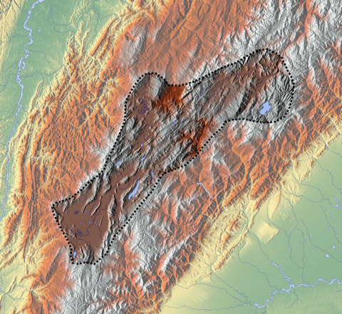
The Las Juntas Formation is apart from its type locality east of Guateque, found in Chingaza National Park,[1] in the El Cochal Synclinal east of the Ocetá Páramo,[6] between Lake Tota and Labranzagrande,[7] other parts of the Tenza Valley such as close to Macanal and Almeida.[8]
The Támara Fault thrusts the Las Juntas Formation southeastward on top of the Tertiary San Fernando and Diablo Formations,[9] and the Chámeza Fault thrusts the older Macanal Formation on top of the Las Juntas Formation around Chámeza, Casanare.[10]
Regional correlations
See also
References
Bibliography
- Acosta Garay, Jorge E., and Carlos E. Ulloa Melo. 2002. Mapa Geológico del Departamento de Cundinamarca - 1:250,000 - Memoria explicativa, 1–108. INGEOMINAS. Accessed 2017-04-26.
- Rodríguez Parra, Antonio José, and Orlando Solano Silva. 2000. Mapa Geológico del Departamento de Boyacá - 1:250,000 - Memoria explicativa, 1–120. INGEOMINAS.
- Villamil, Tomas. 2012. Chronology Relative Sea Level History and a New Sequence Stratigraphic Model for Basinal Cretaceous Facies of Colombia, 161–216. Society for Sedimentary Geology (SEPM).
Maps
- Ulloa, Carlos E.; Álvaro Guerra, and Ricardo Escovar. 1998. Plancha 172 - Paz de Río - 1:100,000, 1. INGEOMINAS. Accessed 2017-06-06.
- Ulloa, Carlos E.; Erasmo Rodríguez, and Ricardo Escovar. 1998. Plancha 192 - Laguna de Tota - 1:100,000, 1. INGEOMINAS. Accessed 2017-06-06.
- Renzoni, Giancarlo. 1992. Plancha 193 - Yopal - 1:100,000, 1. INGEOMINAS. Accessed 2017-06-06.
- Terraza, Roberto; Giovanni Moreno; José A. Buitrago; Adrián Pérez, and Diana María Montoya. 2010. Plancha 210 - Guateque - 1:100,000, 1. INGEOMINAS. Accessed 2017-06-06.
- Ulloa, Carlos, and Erasmo Rodríguez. 2009. Plancha 211 - Tauramena - 1:100,000, 1. INGEOMINAS. Accessed 2017-06-06.
- Buitrago, José Alberto; Roberto Terraza M., and Fernando Etayo. 1998. Plancha 228 - Santafé de Bogotá Noreste - 1:100,000, 1. INGEOMINAS. Accessed 2017-06-06.
External links
- Gómez, J.; N.E. Montes; Á. Nivia, and H. Diederix. 2015. Plancha 5-09 del Atlas Geológico de Colombia 2015 – escala 1:500,000, 1. Servicio Geológico Colombiano. Accessed 2017-03-16.
| Geology |
|  | |||
|---|---|---|---|---|---|
| History |
| ||||
| Main mining areas |
| ||||
| Individual mines | |||||
| Individual emeralds (ct) |
| ||||
| Related articles | |||||
| |||||