Rosablanca Formation
| Rosablanca Formation Stratigraphic range: Valanginian ~136–133 Ma | |
|---|---|
| Type | Geological formation |
| Underlies | Paja Fm., Ritoque Fm. |
| Overlies | Cumbres Fm., Girón Fm., Los Medios Fm. |
| Thickness | ~470 m (1,540 ft) |
| Lithology | |
| Primary | Sandstone |
| Other | Shale |
| Location | |
| Coordinates | 4°27′07″N 74°03′20″W / 4.45194°N 74.05556°WCoordinates: 4°27′07″N 74°03′20″W / 4.45194°N 74.05556°W |
| Region |
Altiplano Cundiboyacense Eastern Ranges, Andes |
| Country |
|
| Type section | |
| Named by | Wheeler |
| Location | Mesa de Los Santos |
| Year defined | 1929 |
| Coordinates | 4°27′07″N 74°03′20″W / 4.45194°N 74.05556°W |
| Region | Boyacá, Santander |
| Country |
|
The Rosablanca Formation (Spanish: Formación Rosablanca, Kir) is a geological formation of the Altiplano Cundiboyacense, Eastern Ranges of the Colombian Andes and the Middle Magdalena Basin. The formation consists of grey limestones, dolomites and shales with at the upper part sandstones. The formation dates to the Early Cretaceous period; Valanginian epoch and has a thickness of 425 metres (1,394 ft) in the valley of the Sogamoso River.
Definition
The formation was first defined by Wheeler in 1929.[1]
Description
Lithologies
The Rosablanca Formation is characterised by a sequence of grey limestones, dolomites and shales with a maximum thickness of 425 metres (1,394 ft) in the Sogamoso River valley.[1] Fossils of Diaulax rosablanca have been found in and named after the Rosablanca Formation.[2]
Stratigraphy and depositional environment
The Rosablanca Formation overlies the Arcabuco Formation and is overlain by the Ritoque Formation. The age has been estimated to be Valanginian. Stratigraphically, the formation is time equivalent with the Macanal Formation.[1]
Outcrops
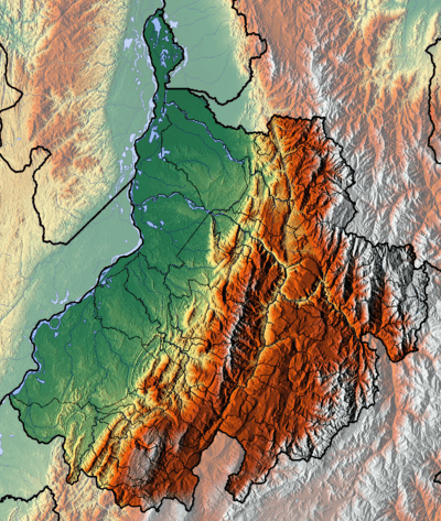
The Rosablanca Formation is found, apart from its type locality on the Mesa de Los Santos, Santander, in Boyacá and the Middle Magdalena Basin.
Regional correlations
See also
References
Bibliography
- Galvis Arenas, Beatriz Elena, and José Leonardo Valencia Escobar. 2009. Contribución en la determinación de los posibles paleoambientes de las rocas Cretáceas Tempranas sobre la vía Tunja-Villa de Leyva (entre Alto del Arrayán - Peaje Sáchica) y sectores aledaños, departamento de Boyacá, 1–127. Universidad de Caldas.
- Gómez Cruz, Arley de Jesús; Hermann D. Bermúdez, and Francisco J. Vega. 2015. A new species of Diaulax Bell, 1863 (Brachyura: Dialucidae) in the Early Cretaceous of the Rosablanca Formation, Colombia. Boletín de la Sociedad Geológica Mexicana 67. 103-112. Accessed 2017-04-04.
- Villamil, Tomas. 2012. Chronology Relative Sea Level History and a New Sequence Stratigraphic Model for Basinal Cretaceous Facies of Colombia, 161–216. Society for Sedimentary Geology (SEPM).
Maps
- Bernal Vargas, Luis Enrique, and Luis Carlos Mantilla Figueroa. 2006. Plancha 85 - Simití - 1:100,000, 1. INGEOMINAS. Accessed 2017-06-06.
- Bernal Vargas, Luis Enrique, and Luis Carlos Mantilla Figueroa. 2006. Plancha 96 - Bocas del Rosario - 1:100,000, 1. INGEOMINAS. Accessed 2017-06-06.
- Vargas, Rodrigo, and Alfonso Arias. 2009. Plancha 97 - Cáchira - 1:100,000, 1. INGEOMINAS. Accessed 2017-06-06.
- Beltrán, Alejandro, and Claudia I. Quintero. 2008. Plancha 119 - Barrancabermeja - 1:100,000, 1. INGEOMINAS. Accessed 2017-06-06.
- Ward, Dwight E.; Richard Goldsmith; Andrés Jimeno; Jaime Cruz; Hernán Restrepo, and Eduardo Gómez. 2010. Plancha 120 - Bucaramanga - 1:100,000, 1. INGEOMINAS. Accessed 2017-06-06.
- Beltrán, Alejandro; José Alfredo Lancheros; Carolina López; Claudia Chaquea; Alejandro Patiño; Angela Guerra; Julio C. Cabrera; Claudia I. Quintero, and Simón Emilio Molano. 2008. Plancha 134 - Puerto Parra - 1:100,000, 1. INGEOMINAS. Accessed 2017-06-06.
- Angarita, Leonidas; Víctor Carrillo; Alfonso Castro; Rommel Daconte; Mario Niño; Orlando G. Pulido; J. Antonio Rodríguez; José María Royero, and Rosalba Salinas, Carlos Ulloa and Rodrigo Vargas. 2009. Plancha 135 - San Gil - 1:100,000, 1. INGEOMINAS. Accessed 2017-06-06.
- Beltrán, Alejandro; José Alfredo Lancheros; Carolina López; Claudia Chaquea; Alejandro Patiño; Angela Guerra; Julio C. Cabrera; Claudia I. Quintero, and Simón Emilio Molano. 2008. Plancha 150 - Cimitarra - 1:100,000, 1. INGEOMINAS. Accessed 2017-06-06.
- Pulido González, Orlando. 2009. Plancha 151 - Charalá - 1:100,000, 1. INGEOMINAS. Accessed 2017-06-06.
- Ulloa, Carlos E, and Erasmo Rodríguez. 2009. Plancha 170 - Vélez - 1:100,000, 1. INGEOMINAS. Accessed 2017-06-06.
- Renzoni, Giancarlo, and Humberto Rosas. 2009. Plancha 171 - Duitama - 1:100,000, 1. INGEOMINAS. Accessed 2017-06-06.
- Fuquen M., Jaime A, and José F. Osorno M. 2009. Plancha 190 - Chiquinquirá - 1:100,000, 1. INGEOMINAS. Accessed 2017-06-06.
- Renzoni, Giancarlo; Humberto Rosas, and Fernando Etayo Serna. 1998. Plancha 191 - Tunja - 1:100,000, 1. INGEOMINAS. Accessed 2017-06-06.
External links
- Gómez, J.; N.E. Montes; Á. Nivia, and H. Diederix. 2015. Plancha 5-09 del Atlas Geológico de Colombia 2015 – escala 1:500,000, 1. Servicio Geológico Colombiano. Accessed 2017-03-16.
| Geology |
|  | |||
|---|---|---|---|---|---|
| History |
| ||||
| Main mining areas |
| ||||
| Individual mines | |||||
| Individual emeralds (ct) |
| ||||
| Related articles | |||||
| |||||