Une Formation
| Une Formation Stratigraphic range: Albian-Cenomanian ~105–97 Ma | |
|---|---|
| Type | Geological formation |
| Unit of | Villeta Group |
| Underlies | Chipaque Formation |
| Overlies | Fómeque Fm., Tibasosa Fm. |
| Thickness | up to 1,100 m (3,600 ft) |
| Lithology | |
| Primary | Sandstone |
| Location | |
| Coordinates | 4°27′07″N 74°03′20″W / 4.45194°N 74.05556°WCoordinates: 4°27′07″N 74°03′20″W / 4.45194°N 74.05556°W |
| Region |
Altiplano Cundiboyacense Eastern Ranges, Andes |
| Country |
|
| Type section | |
| Named for | Une |
| Named by | Hubach |
| Location | Une |
| Year defined | 1957 |
| Coordinates | 4°27′07″N 74°03′20″W / 4.45194°N 74.05556°W |
| Region | Cundinamarca, Boyacá |
| Country |
|
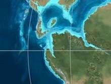
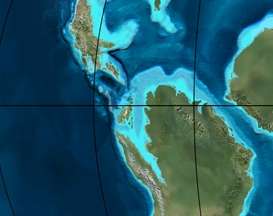 Paleogeography of Northern South America 105 Ma, by Ron Blakey | |
The Une Formation (Spanish: Formación Une, Kiu) is a geological formation of the Altiplano Cundiboyacense, Eastern Ranges of the Colombian Andes. The predominantly sandstone formation dates to the Middle Cretaceous period; Albian to Cenomanian epochs and has a maximum thickness of 1,100 metres (3,600 ft).
Etymology
The formation was defined in 1957 by Hubach after Une, Cundinamarca.[1]
Description
Lithologies
The Une Formation has a maximum thickness of 1,100 metres (3,600 ft) and is characterised by a sequence of sandstones.[2] Fossils of Heminautilus etheringtoni have been found in the Une Formation.[3]
Stratigraphy and depositional environment
The Une Formation, part of the Villeta Group, overlies the Fómeque Formation and is overlain by the Chipaque Formation. The age has been estimated to be Albian-Cenomanian. Stratigraphically, the formation is time equivalent with the Simijaca, Aguardiente, Caballos and Pacho Formations. The formation has been deposited in a near shore deltaic environment.[4]
Outcrops
The Une Formation is apart from its type locality, found on the Sumapaz Páramo.[2]
Regional correlations
See also
References
Bibliography
- Acosta Garay, Jorge E., and Carlos E. Ulloa Melo. 2002. Mapa Geológico del Departamento de Cundinamarca - 1:250,000 - Memoria explicativa, 1–108. INGEOMINAS. Accessed 2017-04-26.
- Badouin, Cyril; Gérard Delanoy; Josep Antón Moreno Bedmar; Antoine Pictet; Jean Vermeulen; Gabriel Conte; Roland Gonnet; Patrick Boselli, and Marc Bonelli. 2016. Revision of the Early Cretaceous genera Heminautilus SPATH, 1927, and Josanautilus MARTÍNEZ & GRAUGES, 2006 (Nautilida, Cenoceratidae). Carnets Geologicás 16. 61-212. Accessed 2017-01-20.
- García González, Mario; Ricardo Mier Umaña; Luis Enrique Cruz Guevara, and Mauricio Vásquez. 2009. Informe Ejecutivo - evaluación del potencial hidrocarburífero de las cuencas colombianas, 1-219. Universidad Industrial de Santander.
- Villamil, Tomas. 2012. Chronology Relative Sea Level History and a New Sequence Stratigraphic Model for Basinal Cretaceous Facies of Colombia, 161–216. Society for Sedimentary Geology (SEPM).
Maps
- Renzoni, Giancarlo, and Humberto Rosas. 2009. Plancha 171 - Duitama - 1:100,000, 1. INGEOMINAS. Accessed 2017-06-06.
- Ulloa, Carlos E.; Álvaro Guerra, and Ricardo Escovar. 1998. Plancha 172 - Paz de Río - 1:100,000, 1. INGEOMINAS. Accessed 2017-06-06.
- Renzoni, Giancarlo; Humberto Rosas, and Fernando Etayo Serna. 1998. Plancha 191 - Tunja - 1:100,000, 1. INGEOMINAS. Accessed 2017-06-06.
- Ulloa, Carlos E.; Erasmo Rodríguez, and Ricardo Escovar. 1998. Plancha 192 - Laguna de Tota - 1:100,000, 1. INGEOMINAS. Accessed 2017-06-06.
- Renzoni, Giancarlo. 1992. Plancha 193 - Yopal - 1:100,000, 1. INGEOMINAS. Accessed 2017-06-06.
- Montoya, Diana María, and Germán Reyes. 2009. Plancha 209 - Zipaquirá - 1:100,000, 1. INGEOMINAS. Accessed 2017-06-06.
- Terraza, Roberto; Giovanni Moreno; José A. Buitrago; Adrián Pérez, and Diana María Montoya. 2010. Plancha 210 - Guateque - 1:100,000, 1. INGEOMINAS. Accessed 2017-06-06.
- Ulloa, Carlos, and Erasmo Rodríguez. 2009. Plancha 211 - Tauramena - 1:100,000, 1. INGEOMINAS. Accessed 2017-06-06.
- Buitrago, José Alberto; Roberto Terraza M., and Fernando Etayo. 1998. Plancha 228 - Santafé de Bogotá Noreste - 1:100,000, 1. INGEOMINAS. Accessed 2017-06-06.
- Acosta, Jorge E., and Carlos E. Ulloa. 1998. Plancha 246 - Fusagasugá - 1:100,000, 1. INGEOMINAS. Accessed 2017-06-06.
- Acosta, Jorge; Juan Carlos Calcedo, and Carlos Ulloa. 1999. Plancha 265 - Icononzo - 1:100,000, 1. INGEOMINAS. Accessed 2017-06-06.
- Pulido, Orlando; Luz Stella Gómez, and Pedro Marín. 1998. Plancha 266 - Villavicencio - 1:100,000, 1. INGEOMINAS. Accessed 2017-06-06.
- Acosta, Jorge; Pablo Caro; Jaime Fuquen, and José Osorno. 2002. Plancha 303 - Colombia - 1:100,000, 1. INGEOMINAS.
External links
- Gómez, J.; N.E. Montes; Á. Nivia, and H. Diederix. 2015. Plancha 5-09 del Atlas Geológico de Colombia 2015 – escala 1:500,000, 1. Servicio Geológico Colombiano. Accessed 2017-03-16.